Still though this seems like they are giving it a much better chance than in other TWOs.wxman57 wrote:Just because the NHC might say this disturbance "could" become a TD doesn't mean there is a good chance of that. I "could" win the lottery tomorrow, but it's not likely. 99L looked pretty good to me this morning, but it's moving so darn fast now that the convection is dissipating. That's good news. No TD tonight or tomorrow, most certainly. Maybe if it slows down in a few days. But there may not be much left by then.
I can still see a spin near 8.5N/42W, by the way. But no convection around it to speak of. No LLC, most likely, either.
99L Invest E of Windwards,Comments,Sat Pics,Models Thread #2
Moderator: S2k Moderators
Forum rules
The posts in this forum are NOT official forecasts and should not be used as such. They are just the opinion of the poster and may or may not be backed by sound meteorological data. They are NOT endorsed by any professional institution or STORM2K. For official information, please refer to products from the National Hurricane Center and National Weather Service.
- Extremeweatherguy
- Category 5

- Posts: 11095
- Joined: Mon Oct 10, 2005 8:13 pm
- Location: Florida
0 likes
- vacanechaser
- Category 5

- Posts: 1461
- Joined: Wed Dec 03, 2003 9:34 pm
- Location: Portsmouth, Va
- Contact:
HurricaneHunter914 wrote:http://www.ssd.noaa.gov/goes/flt/t1/avn.jpg
Usually the convection should be increasing by now, but instead the convection is continuing a small decreasing trend
what makes you say that??? not sure why you ask... the convection does not follow a schedule or time frame.... just becasue we are into late evening, does not mean we would see an increase... sometimes, it passes the diurinal maximum and has little to no change....
Jesse V. Bass III
http://www.vastormphoto.com
Hurricane Intercept Research Team
0 likes
Derek Ortt wrote:No models showed Ivan coming within 300 miles of Grenada when it was at this latitude
Sometimes, all models tend to be wrong, and they tend to have a nroth bias for these waves at veyr low latitudes
That's interesting. When hurricanes track to the east coast (ga, sc nc) the track always seems to error to the south. Gosh, we evacuated numerous times only to have the storm track north ( Hugo, Bertha Fran, etc.) So, 12 hrs + out, if the storm is headed for my neck of the woods, I usually feel comfortable. Not one exception that I can remember tarcking south of prediction, although I think that the forcasting has certainly improved.
0 likes
- vacanechaser
- Category 5

- Posts: 1461
- Joined: Wed Dec 03, 2003 9:34 pm
- Location: Portsmouth, Va
- Contact:
boca wrote:The reason why I bring the track up is when Katrina was predicted to hit Southern Palm Beach County then took a SW track across the state due to strong high pressure forcing it that why. Why wouldn't 99L behave the same way if it developed?
it would have a lot to due with how deep the system is for starters... it would also depend on how strong or how weak the ridge is in conjunction with the strength of the storm.... a lot of times when a system develops further and becomes stronger it has a better chance to turn more northward due to changes in the upper level steering patterns... the placement of the ridge in the case of katrina may have helped lead to this... the NHC was missing data on the ridge if i remember correctly... so it did not pick up on the strength and the position of that ridge...
Jesse V. Bass III
http://www.vastormphoto.com
Hurricane Intercept Research Team
0 likes
-
HurricaneHunter914
- Category 5

- Posts: 4439
- Age: 32
- Joined: Fri Mar 10, 2006 7:36 pm
- Location: College Station, TX
vacanechaser wrote:HurricaneHunter914 wrote:http://www.ssd.noaa.gov/goes/flt/t1/avn.jpg
Usually the convection should be increasing by now, but instead the convection is continuing a small decreasing trend
what makes you say that??? not sure why you ask... the convection does not follow a schedule or time frame.... just becasue we are into late evening, does not mean we would see an increase... sometimes, it passes the diurinal maximum and has little to no change....
Jesse V. Bass III
http://www.vastormphoto.com
Hurricane Intercept Research Team
Sorry about that, I just got a little jumpy because today the convection has just slowly decreased and decreased.
0 likes
Personal Forecast Disclaimer:
The posts in this forum are NOT official forecast and should not be used as such. They are just the opinion of the poster and may or may not be backed by sound meteorological data. They are NOT endorsed by any professional institution or storm2k.org. For official information, please refer to the NHC and NWS products.
The posts in this forum are NOT official forecast and should not be used as such. They are just the opinion of the poster and may or may not be backed by sound meteorological data. They are NOT endorsed by any professional institution or storm2k.org. For official information, please refer to the NHC and NWS products.
For the first time TAFB shows possible Cyclone Formation.[/quote]
Yea luis. They are now analyzing a 1012MB Low. See my other thread.
Possible Cyclone Graphic
Yea luis. They are now analyzing a 1012MB Low. See my other thread.
Possible Cyclone Graphic
0 likes
- vacanechaser
- Category 5

- Posts: 1461
- Joined: Wed Dec 03, 2003 9:34 pm
- Location: Portsmouth, Va
- Contact:
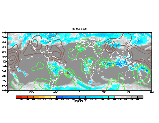
the mjo is in the gulf region now... not even in the atlantic yet... the green represents upward motion... or more favorable conditions for convection to increase in the atlantic...

Jesse V. Bass III
http://www.vastormphoto.com
Hurricane Intercept Research Team

Jesse V. Bass III
http://www.vastormphoto.com
Hurricane Intercept Research Team
0 likes
-
Matt-hurricanewatcher
-
Matt-hurricanewatcher
Cyclenall wrote:mike815 wrote:worlds smallest violin
Where did that come from?There are some people that need to apply for a job at the circus, because they sure know how to fold a tent.
Where did that come from!!
I was talking about everytime convection dies out a little some people want to kill the system ( fold the tent).
0 likes
Dvarak estimates are still too weak. However, they analyze the center at 8.5n and 42.8W.
http://www.ssd.noaa.gov/PS/TROP/positions.html
http://www.ssd.noaa.gov/PS/TROP/positions.html
0 likes
mobilebay wrote:I was talking about everytime convection dies out a little some people want to kill the system ( fold the tent).
I thought that's what you mean't. I never heard the expression "Fold the tent" before.
idk just thought u would like to hear the worlds smallest violin boohooo and i really dont know where it came from
0 likes
Who is online
Users browsing this forum: cycloneye, jconsor, Kingarabian, ljmac75 and 430 guests


