WPAC : TROPICAL DEPRESSION MIRINAE (23W)
Moderator: S2k Moderators
-
cycloneye

- Admin

- Posts: 149205
- Age: 69
- Joined: Thu Oct 10, 2002 10:54 am
- Location: San Juan, Puerto Rico
Re: WPAC : SEVERE TROPICAL STORM MIRINAE (23W)
I eco the above.I am glad that all ended fine under the circunstances and all our friends are safe and sound.Hopefully,this is the last threat of this year for that country.
0 likes
Visit the Caribbean-Central America Weather Thread where you can find at first post web cams,radars
and observations from Caribbean basin members Click Here
and observations from Caribbean basin members Click Here


-
oaba09
- S2K Supporter

- Posts: 1496
- Age: 39
- Joined: Thu Oct 01, 2009 10:02 am
- Location: Valenzuela, Philippines
- Contact:
Re:
leanne_uk wrote:Do you think this will head towards vietnam? My cousin is out there working for 6 weeks and i am a little worried:(
It seems to be heading there right now.....In a positive note, the land interaction it had w/ our country significantly weakened it........
0 likes


-
cycloneye
- Admin
- Posts: 149205
- Age: 69
- Joined: Thu Oct 10, 2002 10:54 am
- Location: San Juan, Puerto Rico
Re: WPAC : SEVERE TROPICAL STORM MIRINAE (23W)
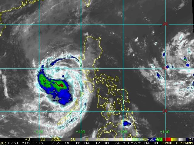
Jma 12:00 UTC Warning:
This is for leanne_uk to let him know about the latest forecast.The good news is that it wont be a strong system when it makes landfall in Vietnam.
STS 0921 (Mirinae)
Issued at 12:40 UTC, 31 October 2009
<Analyses at 31/12 UTC>
Scale -
Intensity -
Center position N14°10'(14.2°)
E117°50'(117.8°)
Direction and speed of movement W 20km/h(12kt)
Central pressure 985hPa
Maximum wind speed near the center 25m/s(50kt)
Maximum wind gust speed 35m/s(70kt)
Area of 30kt winds or more N300km(160NM)
S220km(120NM)
<Forecast for 01/12 UTC>
Intensity -
Center position of probability circle N13°40'(13.7°)
E112°50'(112.8°)
Direction and speed of movement W 20km/h(12kt)
Central pressure 985hPa
Maximum wind speed near the center 25m/s(50kt)
Maximum wind gust speed 35m/s(70kt)
Radius of probability circle 140km(75NM)
<Forecast for 02/12 UTC>
Intensity -
TD
Center position of probability circle N11°30'(11.5°)
E107°20'(107.3°)
Direction and speed of movement WSW 30km/h(15kt)
Central pressure 1002hPa
Radius of probability circle 300km(160NM)
0 likes
Visit the Caribbean-Central America Weather Thread where you can find at first post web cams,radars
and observations from Caribbean basin members Click Here
and observations from Caribbean basin members Click Here
-
metenthusiast

- Category 1

- Posts: 271
- Age: 48
- Joined: Sun Oct 18, 2009 1:09 am
- Location: Manila, Phllippines
- Contact:
Re:
drdavisjr wrote:Has anyone heard from metenthusiast?
Hello guys! Just finished from wallowing in frustration with Mirinae...
0 likes
-
cycloneye
- Admin
- Posts: 149205
- Age: 69
- Joined: Thu Oct 10, 2002 10:54 am
- Location: San Juan, Puerto Rico
Re: WPAC : SEVERE TROPICAL STORM MIRINAE (23W)
12:00Z JTWC Warning=50kts:
To leanne_uk,this the latest forecast and track from JTWC.
WTPN32 PGTW 311500
MSGID/GENADMIN/NAVMARFCSTCEN PEARL HARBOR HI/JTWC//
SUBJ/TROPICAL CYCLONE WARNING//
RMKS/
1. TROPICAL STORM 23W (MIRINAE) WARNING NR 023
01 ACTIVE TROPICAL CYCLONE IN NORTHWESTPAC
MAX SUSTAINED WINDS BASED ON ONE-MINUTE AVERAGE
WIND RADII VALID OVER OPEN WATER ONLY
---
WARNING POSITION:
311200Z --- NEAR 14.3N 117.8E
MOVEMENT PAST SIX HOURS - 270 DEGREES AT 11 KTS
POSITION ACCURATE TO WITHIN 060 NM
POSITION BASED ON CENTER LOCATED BY SATELLITE
PRESENT WIND DISTRIBUTION:
MAX SUSTAINED WINDS - 050 KT, GUSTS 065 KT
WIND RADII VALID OVER OPEN WATER ONLY
RADIUS OF 034 KT WINDS - 080 NM NORTHEAST QUADRANT
060 NM SOUTHEAST QUADRANT
055 NM SOUTHWEST QUADRANT
080 NM NORTHWEST QUADRANT
REPEAT POSIT: 14.3N 117.8E
---
FORECASTS:
12 HRS, VALID AT:
010000Z --- 14.1N 115.1E
MAX SUSTAINED WINDS - 050 KT, GUSTS 065 KT
WIND RADII VALID OVER OPEN WATER ONLY
RADIUS OF 034 KT WINDS - 075 NM NORTHEAST QUADRANT
060 NM SOUTHEAST QUADRANT
055 NM SOUTHWEST QUADRANT
075 NM NORTHWEST QUADRANT
VECTOR TO 24 HR POSIT: 260 DEG/ 13 KTS
---
24 HRS, VALID AT:
011200Z --- 13.7N 112.4E
MAX SUSTAINED WINDS - 050 KT, GUSTS 065 KT
WIND RADII VALID OVER OPEN WATER ONLY
RADIUS OF 034 KT WINDS - 075 NM NORTHEAST QUADRANT
060 NM SOUTHEAST QUADRANT
055 NM SOUTHWEST QUADRANT
075 NM NORTHWEST QUADRANT
VECTOR TO 36 HR POSIT: 255 DEG/ 13 KTS
---
36 HRS, VALID AT:
020000Z --- 13.1N 109.8E
MAX SUSTAINED WINDS - 045 KT, GUSTS 055 KT
WIND RADII VALID OVER OPEN WATER ONLY
RADIUS OF 034 KT WINDS - 050 NM NORTHEAST QUADRANT
045 NM SOUTHEAST QUADRANT
045 NM SOUTHWEST QUADRANT
055 NM NORTHWEST QUADRANT
VECTOR TO 48 HR POSIT: 255 DEG/ 13 KTS
---
EXTENDED OUTLOOK:
48 HRS, VALID AT:
021200Z --- 12.3N 107.2E
MAX SUSTAINED WINDS - 020 KT, GUSTS 030 KT
WIND RADII VALID OVER OPEN WATER ONLY
DISSIPATED AS A SIGNIFICANT TROPICAL CYCLONE OVER LAND
---
REMARKS:
311500Z POSITION NEAR 14.3N 117.1E.
TROPICAL STORM 23W (MIRINAE), LOCATED APPROXIMATELY 690 NM EAST-
NORTHEAST OF HO CHI MINH, VIETNAM, HAS TRACKED WESTWARD AT 11 KNOTS
OVER THE PAST SIX HOURS. MAXIMUM SIGNIFICANT WAVE HEIGHT AT 311200Z
IS 14 FEET. NEXT WARNINGS AT 312100Z, 010300Z, 010900Z AND 011500Z.//
NNNN
0 likes
Visit the Caribbean-Central America Weather Thread where you can find at first post web cams,radars
and observations from Caribbean basin members Click Here
and observations from Caribbean basin members Click Here
-
Typhoon Hunter
- WesternPacificWeather.com

- Posts: 1222
- Joined: Wed Oct 11, 2006 11:37 am
- Location: Tokyo
- Contact:
Re: WPAC : SEVERE TROPICAL STORM MIRINAE (23W)
Video I shot with Jim Edds from around the Laguna de Bay area:
http://www.youtube.com/watch?v=Kx7_Qiy7Lok
http://www.youtube.com/watch?v=Kx7_Qiy7Lok
0 likes
-
oaba09
- S2K Supporter
- Posts: 1496
- Age: 39
- Joined: Thu Oct 01, 2009 10:02 am
- Location: Valenzuela, Philippines
- Contact:
Re: WPAC : SEVERE TROPICAL STORM MIRINAE (23W)
Typhoon Hunter wrote:Video I shot with Jim Edds from around the Laguna de Bay area:
http://www.youtube.com/watch?v=Kx7_Qiy7Lok
Great video...it shows how powerful this typhoon was even at it's weakened state...
0 likes
-
cycloneye
- Admin
- Posts: 149205
- Age: 69
- Joined: Thu Oct 10, 2002 10:54 am
- Location: San Juan, Puerto Rico
Re: WPAC : SEVERE TROPICAL STORM MIRINAE (23W)
Jim,were you ok after that fall there? That video is good showing all the details of the winds and surf.Also some of those people in those swamps would haved been swept away by that surf,thankfully nothing occured.
0 likes
Visit the Caribbean-Central America Weather Thread where you can find at first post web cams,radars
and observations from Caribbean basin members Click Here
and observations from Caribbean basin members Click Here
Re: WPAC : SEVERE TROPICAL STORM MIRINAE (23W)
Thanks for posting that! WOW at the young folks out playing around by the sea in those winds!!
0 likes

Re: WPAC : SEVERE TROPICAL STORM MIRINAE (23W)
breeze wrote:Thanks for posting that! WOW at the young folks out playing around by the sea in those winds!!
Yes, that was risky. It's a great video.
0 likes
-
cycloneye
- Admin
- Posts: 149205
- Age: 69
- Joined: Thu Oct 10, 2002 10:54 am
- Location: San Juan, Puerto Rico
Re: WPAC : SEVERE TROPICAL STORM MIRINAE (23W)
Sad News=7 dead,5 are missing
Despite this system not being a strong typhoon,it has left its sad mark.
http://www.msnbc.msn.com/id/33562352/ns/weather/
MANILA, Philippines - A typhoon battered the Philippine capital and surrounding provinces still reeling from recent flooding, sending residents of one town clambering onto rooftops Saturday to escape rising waters. At least seven people died and at least five were missing.
Typhoon Mirinae was the fourth storm to lash the northern Philippines since late September and brought new hardship to areas still struggling in the wake of the previous disasters. Nearly 95,000 people who fled during two prior storms were still living in temporary shelters when Mirinae struck, the national disaster agency said.
Saturday's storm headed out to sea in the afternoon and weakened into a tropical storm. It appeared to be heading toward Vietnam.
As Mirinae slammed into Quezon province northeast of Manila around midnight Friday, Philippine authorities evacuated more than 115,000 people in nine provinces east and south of the capital in the storm's path on main Luzon island, the National Disaster Coordinating Council reported. At its height, its winds were blowing 93 miles per hour and gusting up to 115 mph.
One river in Laguna province, south of Manila, overflowed, washing away a bridge and flooding most of lakeside Santa Cruz town. Residents clambered onto roofs to escape the waters, said Mayor Ariel Magcalas.
"We cannot move, this is no joke. The water is high. We need help," Magcalas said in a public address on Radio DZBB early Saturday.
The muddy floodwater receded as rains eased later in the day, but was still chest-high in some communities.
In Manila, residents hunkered down in their homes overnight as rains beat down on dark, deserted streets. Mirinae passed south of the city of 12 million. The sprawling metropolis saw its worst flooding in 40 years in late September when Tropical Storm Ketsana hit the capital and nearby provinces. In many suburban communities, the floodwaters had still not receded when Mirinae struck.
0 likes
Visit the Caribbean-Central America Weather Thread where you can find at first post web cams,radars
and observations from Caribbean basin members Click Here
and observations from Caribbean basin members Click Here
-
cycloneye
- Admin
- Posts: 149205
- Age: 69
- Joined: Thu Oct 10, 2002 10:54 am
- Location: San Juan, Puerto Rico
Re: WPAC : SEVERE TROPICAL STORM MIRINAE (23W)
JMA downgrades to Tropical Storm.
TS 0921 (Mirinae)
Issued at 18:40 UTC, 31 October 2009
<Analyses at 31/18 UTC>
Scale -
Intensity -
Center position N14°00'(14.0°)
E116°35'(116.6°)
Direction and speed of movement W 20km/h(11kt)
Central pressure 990hPa
Maximum wind speed near the center 23m/s(45kt)
Maximum wind gust speed 35m/s(65kt)
Area of 30kt winds or more W300km(160NM)
E220km(120NM)
<Forecast for 01/18 UTC>
Intensity -
Center position of probability circle N12°55'(12.9°)
E111°30'(111.5°)
Direction and speed of movement W 25km/h(13kt)
Central pressure 990hPa
Maximum wind speed near the center 23m/s(45kt)
Maximum wind gust speed 35m/s(65kt)
Radius of probability circle 140km(75NM)
<Forecast for 02/18 UTC>
Intensity -
TD
Center position of probability circle N10°35'(10.6°)
E106°10'(106.2°)
Direction and speed of movement WSW 25km/h(14kt)
Central pressure 1002hPa
Radius of probability circle 330km(180NM)
0 likes
Visit the Caribbean-Central America Weather Thread where you can find at first post web cams,radars
and observations from Caribbean basin members Click Here
and observations from Caribbean basin members Click Here


-
cycloneye
- Admin
- Posts: 149205
- Age: 69
- Joined: Thu Oct 10, 2002 10:54 am
- Location: San Juan, Puerto Rico
Re: WPAC : TROPICAL STORM MIRINAE (23W)
18:00Z JTWC Warning=45kts.
WTPN32 PGTW 312100
MSGID/GENADMIN/NAVMARFCSTCEN PEARL HARBOR HI/JTWC//
SUBJ/TROPICAL CYCLONE WARNING//
RMKS/
1. TROPICAL STORM 23W (MIRINAE) WARNING NR 024
01 ACTIVE TROPICAL CYCLONE IN NORTHWESTPAC
MAX SUSTAINED WINDS BASED ON ONE-MINUTE AVERAGE
WIND RADII VALID OVER OPEN WATER ONLY
---
WARNING POSITION:
311800Z --- NEAR 14.1N 116.2E
MOVEMENT PAST SIX HOURS - 265 DEGREES AT 16 KTS
POSITION ACCURATE TO WITHIN 060 NM
POSITION BASED ON CENTER LOCATED BY SATELLITE
PRESENT WIND DISTRIBUTION:
MAX SUSTAINED WINDS - 045 KT, GUSTS 055 KT
WIND RADII VALID OVER OPEN WATER ONLY
RADIUS OF 034 KT WINDS - 080 NM NORTHEAST QUADRANT
060 NM SOUTHEAST QUADRANT
055 NM SOUTHWEST QUADRANT
080 NM NORTHWEST QUADRANT
REPEAT POSIT: 14.1N 116.2E
---
FORECASTS:
12 HRS, VALID AT:
010600Z --- 13.8N 113.5E
MAX SUSTAINED WINDS - 040 KT, GUSTS 050 KT
WIND RADII VALID OVER OPEN WATER ONLY
RADIUS OF 034 KT WINDS - 075 NM NORTHEAST QUADRANT
060 NM SOUTHEAST QUADRANT
055 NM SOUTHWEST QUADRANT
075 NM NORTHWEST QUADRANT
VECTOR TO 24 HR POSIT: 260 DEG/ 13 KTS
---
24 HRS, VALID AT:
011800Z --- 13.3N 110.9E
MAX SUSTAINED WINDS - 040 KT, GUSTS 050 KT
WIND RADII VALID OVER OPEN WATER ONLY
RADIUS OF 034 KT WINDS - 060 NM NORTHEAST QUADRANT
050 NM SOUTHEAST QUADRANT
045 NM SOUTHWEST QUADRANT
065 NM NORTHWEST QUADRANT
VECTOR TO 36 HR POSIT: 255 DEG/ 14 KTS
---
36 HRS, VALID AT:
020600Z --- 12.6N 108.2E
MAX SUSTAINED WINDS - 020 KT, GUSTS 030 KT
WIND RADII VALID OVER OPEN WATER ONLY
DISSIPATED AS A SIGNIFICANT TROPICAL CYCLONE OVER LAND
---
REMARKS:
312100Z POSITION NEAR 14.0N 115.5E.
TROPICAL STORM 23W (MIRINAE), LOCATED APPROXIMATELY 590 NM EAST-
NORTHEAST OF HO CHI MINH, VIETNAM, HAS TRACKED WESTWARD AT 16 KNOTS
OVER THE PAST SIX HOURS. ANIMATED INFRARED SATELLITE IMAGERY SHOWS
THAT CONVECTION HAS CONTINUED TO DIMINISH OVER THE PAST SIX HOURS
ALONG THE SOUTHERN HALF OF MIRINAE. A 311059Z QUIKSCAT PASS SHOWED
THAT THE LOW LEVEL CIRCULATION CENTER (LLCC) HAS MAINTAINED A
SYMMETRICAL STRUCTURE WITH UNFLAGGED 45 KNOT WINDS PRESENT. THE
STRONG NORTHEASTERLY COLD SURGE FROM THE NORTHEAST IS ALSO READILY
APPARENT ON THE NORTHWESTERN QUADRANT OF TS 23W, AND IS EXPECTED TO
CONTINUE WEAKENING THE LLCC WITH DRY AIR ENTRAINMENT AND INCREASING
VERTICAL WIND SHEAR. THE CURRENT FORECAST REMAINS CONSISTENT WITH
THE PREVIOUS FORECAST PHILOSOPHY, AS THE SYSTEM CONTINUES TO TRACK
TOWARDS CENTRAL VIETNAM, STEADILY WEAKENING. LANDFALL IS EXPECTED TO
OCCUR AROUND TAU 30 WITH COMPLETE DISSIPATION BY TAU 36. MAXIMUM
SIGNIFICANT WAVE HEIGHT AT 311800Z IS 14 FEET. NEXT WARNINGS AT
010300Z, 010900Z, 011500Z AND 012100Z.//
NNNN
0 likes
Visit the Caribbean-Central America Weather Thread where you can find at first post web cams,radars
and observations from Caribbean basin members Click Here
and observations from Caribbean basin members Click Here
-
ozonepete
- Professional-Met

- Posts: 4743
- Joined: Mon Sep 07, 2009 3:23 pm
- Location: From Ozone Park, NYC / Now in Brooklyn, NY
Re: WPAC : SEVERE TROPICAL STORM MIRINAE (23W)
Typhoon Hunter wrote:Video I shot with Jim Edds from around the Laguna de Bay area:
http://www.youtube.com/watch?v=Kx7_Qiy7Lok
Great video, guys. What was that floating vegetation that they were trying to save?
0 likes
-
vbhoutex

- Storm2k Executive
- Posts: 29143
- Age: 74
- Joined: Wed Oct 09, 2002 11:31 pm
- Location: Cypress, TX
- Contact:
Re: WPAC : SEVERE TROPICAL STORM MIRINAE (23W)
ozonepete wrote:Typhoon Hunter wrote:Video I shot with Jim Edds from around the Laguna de Bay area:
http://www.youtube.com/watch?v=Kx7_Qiy7Lok
Great video, guys. What was that floating vegetation that they were trying to save?
I think they were trying to save the board debris and not the plants. They probably can use it for their homes or maybe to sell. JMHO.
0 likes
Skywarn, C.E.R.T.
Please click below to donate to STORM2K to help with the expenses of keeping the site going:

Please click below to donate to STORM2K to help with the expenses of keeping the site going:
Who is online
Users browsing this forum: No registered users and 20 guests