ATL: BERYL - Post-Tropical
Moderator: S2k Moderators
-
dexterlabio
- Category 5

- Posts: 3503
- Joined: Sat Oct 24, 2009 11:50 pm
Re: ATL: BERYL - Tropical Depression
well i'm quite impressed how Beryl stays as a depression inland and didn't degenerate back into a tropical disturbance.
0 likes
Personal Forecast Disclaimer:
The posts in this forum are NOT official forecast and should not be used as such. They are just the opinion of the poster and may or may not be backed by sound meteorological data. They are NOT endorsed by any professional institution or storm2k.org. For official information, please refer to the NHC and NWS products.
The posts in this forum are NOT official forecast and should not be used as such. They are just the opinion of the poster and may or may not be backed by sound meteorological data. They are NOT endorsed by any professional institution or storm2k.org. For official information, please refer to the NHC and NWS products.
-
tolakram
- Admin

- Posts: 20179
- Age: 62
- Joined: Sun Aug 27, 2006 8:23 pm
- Location: Florence, KY (name is Mark)
Re: ATL: BERYL - Tropical Depression
0 likes
M a r k
- - - - -
Join us in chat: Storm2K Chatroom Invite. Android and IOS apps also available.
The posts in this forum are NOT official forecasts and should not be used as such. Posts are NOT endorsed by any professional institution or STORM2K.org. For official information and forecasts, please refer to NHC and NWS products.
-
WilmingtonSandbar
- S2K Supporter

- Posts: 505
- Joined: Sun Aug 29, 2010 12:11 pm
- Location: Southport, NC
-
Riptide

- Category 2

- Posts: 753
- Age: 34
- Joined: Fri Jul 23, 2010 3:33 pm
- Location: Cape May, New Jersey
- Contact:
Re: ATL: BERYL - Tropical Depression
Getting rain from Beryl right now, it has been quite dry.
0 likes
-
WilmingtonSandbar
- S2K Supporter
- Posts: 505
- Joined: Sun Aug 29, 2010 12:11 pm
- Location: Southport, NC
-
wxman57

- Moderator-Pro Met

- Posts: 23172
- Age: 68
- Joined: Sat Jun 21, 2003 8:06 pm
- Location: Houston, TX (southwest)
Re: ATL: BERYL - Tropical Depression
Don't know if Beryl will be upgraded to a TS today. Problem is, it's losing tropical characteristics already. Possibly an STS again as it heads out to sea.
0 likes
-
mf_dolphin

- Category 5
- Posts: 17758
- Age: 69
- Joined: Tue Oct 08, 2002 2:05 pm
- Location: St Petersburg, FL
- Contact:

Re: ATL: BERYL - Tropical Depression
tornado touch down in carteret co homes destroyed...so far have not heard of any one hurt...poring rain side ways at times....more tornado warnings coming out for surrounding area
0 likes
CARTERET COUNTY NC
-
Dave

- Retired Staff

- Posts: 13442
- Age: 75
- Joined: Tue Aug 01, 2006 3:57 pm
- Location: Milan Indiana
- Contact:
Put Beryl in the books...Recon missions are cancelled.
WEATHER RECONNAISSANCE FLIGHTS
CARCAH, NATIONAL HURRICANE CENTER, MIAMI, FL.
0815 AM EDT WED 30 MAY 2012
SUBJECT: TROPICAL CYCLONE PLAN OF THE DAY (TCPOD)
VALID 31/1100Z MAY TO 01/1100Z JUN 2012
TCPOD NUMBER.....12-012
I. ATLANTIC REQUIREMENTS
1. NEGATIVE RECONNAISSANCE REQUIREMENTS.
2. OUTLOOK FOR SUCCEEDING DAY.....NEGATIVE.
3. REMARKS: MISSION ON TD BERYL FOR 30/1800Z
AND 31/0000Z CANCELED BY NHC AT 30/1200Z.
RE: SYSTEM OVERLAND, HAS NO CORE AND IS
BECOMING EXTRATROPICAL.
II. PACIFIC REQUIREMENTS
1. NEGATIVE RECONNAISSANCE REQUIREMENTS.
2. SUCCEEDING DAY OUTLOOK.....NEGATIVE.
JWP
0 likes
This post is NOT AN OFFICIAL FORECAST and should not be used as such. It is just the opinion of the poster and may or may not be backed by sound meteorological data. It is NOT endorsed by any professional institution including storm2k.org. For Official Information please refer to the NHC and NWS products.
-
Dave
- Retired Staff
- Posts: 13442
- Age: 75
- Joined: Tue Aug 01, 2006 3:57 pm
- Location: Milan Indiana
- Contact:
For an update, the leak in our friends brain sealed early Monday morning and as of today, he can lift and move his arm & legs and is awake joking with the nurses. He does have some damage to his vision and a few other things that will require rehab but so far it looks much better than before. He did have a massive stroke but his recovery is remarkable to this point. He is still in ICU but from the doctors & specialists, they feel he's made it past the most critical times at this point. All Bart wants to do is come HOME! <<< his exact words to his youngest son this morning. Thanks for all the prayers and everything guys/gals...nice to be a part of a family that cares like you all do....means a lot!
0 likes
This post is NOT AN OFFICIAL FORECAST and should not be used as such. It is just the opinion of the poster and may or may not be backed by sound meteorological data. It is NOT endorsed by any professional institution including storm2k.org. For Official Information please refer to the NHC and NWS products.
-
TeamPlayersBlue

- Category 5
- Posts: 3529
- Joined: Tue Feb 02, 2010 1:44 am
- Location: Denver/Applewood, CO
It will get TS status i think when it is offshore. Might get up to 50 MPH
edit by tolakram: added disclaimer
Personal Forecast Disclaimer:
The posts in this forum are NOT official forecast and should not be used as such. They are just the opinion of the poster and may or may not be backed by sound meteorological data. They are NOT endorsed by any professional institution or storm2k.org. For official information, please refer to the NHC and NWS products.
edit by tolakram: added disclaimer
0 likes
Personal Forecast Disclaimer:
The posts in this forum are NOT official forecast and should not be used as such. They are just the opinion of the poster and may or may not be backed by sound meteorological data. They are NOT endorsed by any professional institution or storm2k.org. For official information, please refer to the NHC and NWS products.
The posts in this forum are NOT official forecast and should not be used as such. They are just the opinion of the poster and may or may not be backed by sound meteorological data. They are NOT endorsed by any professional institution or storm2k.org. For official information, please refer to the NHC and NWS products.
-
TropicalAnalystwx13

- Category 5
- Posts: 2109
- Age: 28
- Joined: Tue Jul 19, 2011 8:20 pm
- Location: Wilmington, NC
- Contact:

-
cycloneye

- Admin
- Posts: 149275
- Age: 69
- Joined: Thu Oct 10, 2002 10:54 am
- Location: San Juan, Puerto Rico
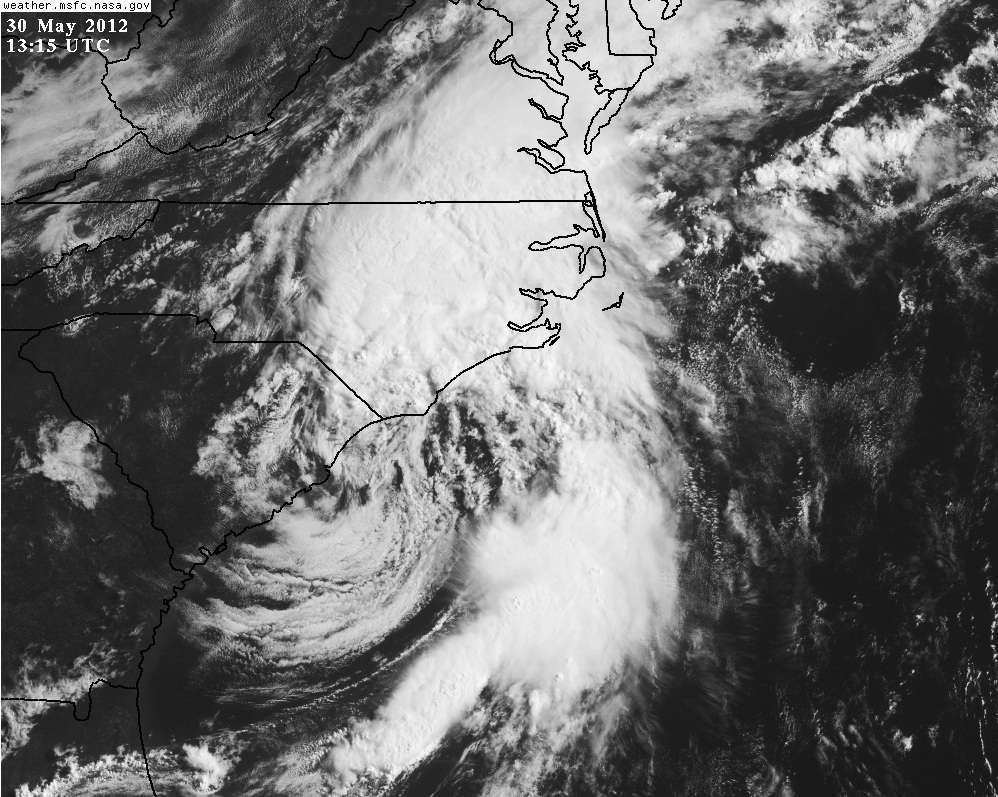
Re: ATL: BERYL - Tropical Depression
It was a good system to watch before June 1rst that almost turned into a hurricane,but it all has to end. Maybe an upgrade to hurricane on post season report?
30/1745 UTC 33.9N 77.1W EXTRATROPICAL BERYL -- Atlantic
http://www.ssd.noaa.gov/PS/TROP/tdpositions.html
30/1745 UTC 33.9N 77.1W EXTRATROPICAL BERYL -- Atlantic
http://www.ssd.noaa.gov/PS/TROP/tdpositions.html
0 likes
Visit the Caribbean-Central America Weather Thread where you can find at first post web cams,radars
and observations from Caribbean basin members Click Here
and observations from Caribbean basin members Click Here
-
seahawkjd
- S2K Supporter
- Posts: 632
- Joined: Wed Sep 10, 2003 4:12 pm
- Location: Morehead City, NC
- Contact:
Re: ATL: BERYL - Tropical Depression
http://www2.wnct.com/news/weather/2012/ ... r-2308538/
Police are reporting 5 homes destroyed 40-50 damaged.
Police are reporting 5 homes destroyed 40-50 damaged.
0 likes
Gloria, Hugo, Emily, Bertha, Bonnie, Dennis (twice), Fran, Floyd, Isabel, Irene, Arthur, Matthew, Florence, Dorian (and many tropical storms and nor'easters).

-
cycloneye
- Admin
- Posts: 149275
- Age: 69
- Joined: Thu Oct 10, 2002 10:54 am
- Location: San Juan, Puerto Rico
Re: ATL: BERYL - Advisories
Last Written Advisory
BULLETIN
POST-TROPICAL CYCLONE BERYL ADVISORY NUMBER 20
NWS NATIONAL HURRICANE CENTER MIAMI FL AL022012
500 PM EDT WED MAY 30 2012
...BERYL IS NOW A POST-TROPICAL CYCLONE...THIS IS THE LAST
ADVISORY...
SUMMARY OF 500 PM EDT...2100 UTC...INFORMATION
----------------------------------------------
LOCATION...34.9N 76.1W
ABOUT 40 MI...65 KM WSW OF CAPE HATTERAS NORTH CAROLINA
MAXIMUM SUSTAINED WINDS...40 MPH...65 KM/H
PRESENT MOVEMENT...ENE OR 60 DEGREES AT 21 MPH...33 KM/H
MINIMUM CENTRAL PRESSURE...998 MB...29.47 INCHES
WATCHES AND WARNINGS
--------------------
THERE ARE NO COASTAL TROPICAL CYCLONE WATCHES OR WARNINGS IN EFFECT.
FOR STORM INFORMATION SPECIFIC TO YOUR AREA...PLEASE MONITOR
PRODUCTS ISSUED BY YOUR LOCAL NATIONAL WEATHER SERVICE FORECAST
OFFICE.
DISCUSSION AND 48-HOUR OUTLOOK
------------------------------
AT 500 PM EDT...2100 UTC...THE CENTER OF POST-TROPICAL CYCLONE BERYL
WAS ESTIMATED NEAR LATITUDE 34.9 NORTH...LONGITUDE 76.1 WEST. THE
POST-TROPICAL CYCLONE IS MOVING NORTHEASTWARD AT 21 MPH...33 KM/H.
A GENERAL NORTHEASTWARD OR EAST-NORTHEASTWARD MOTION WITH AN
INCREASE IN FORWARD SPEED IS EXPECTED DURING THE NEXT COUPLE OF
DAYS.
MAXIMUM SUSTAINED WINDS HAVE INCREASED AND ARE NOW NEAR 40 MPH...65
KM/H...WITH HIGHER GUSTS. SOME ADDITIONAL STRENGTHENING OF THE
POST-TROPICAL CYCLONE IS EXPECTED OVER THE NEXT DAY OR TWO.
GALE-FORCE WINDS EXTEND OUTWARD UP TO 105 MILES...165 KM MAINLY EAST
AND SOUTH OF THE CENTER.
ESTIMATED MINIMUM CENTRAL PRESSURE IS 998 MB...29.47 INCHES.
HAZARDS AFFECTING LAND
----------------------
WIND...GALE-FORCE WIND GUSTS ARE POSSIBLE ALONG THE COAST OF NORTH
CAROLINA THROUGH TONIGHT.
SURF...DANGEROUS SURF CONDITIONS...INCLUDING RIP CURRENTS...ARE
POSSIBLE ALONG THE COASTS OF NORTH CAROLINA AND SOUTHEASTERN
VIRGINIA THIS EVENING.
RAINFALL...BERYL IS EXPECTED TO PRODUCE TOTAL RAIN ACCUMULATIONS
OF 2 TO 4 INCHES OVER EXTREME NORTHEASTERN NORTH CAROLINA...AND 1 TO
3 INCHES OVER EXTREME SOUTHEASTERN VIRGINIA. ISOLATED MAXIMUM
AMOUNTS OF 10 TO 12 INCHES ARE POSSIBLE ACROSS PORTIONS OF FAR
NORTHEASTERN NORTH CAROLINA.
NEXT ADVISORY
-------------
THIS IS THE LAST PUBLIC ADVISORY ISSUED BY THE NATIONAL HURRICANE
CENTER ON THIS SYSTEM. ADDITIONAL INFORMATION ON THIS SYSTEM CAN BE
FOUND IN HIGH SEAS FORECASTS ISSUED BY THE NATIONAL WEATHER
SERVICE...UNDER AWIPS HEADER NFDHSFAT1 AND WMO HEADER FZNT01 KWBC.
$$
FORECASTER CANGIALOSI/FRANKLIN
POST-TROPICAL CYCLONE BERYL DISCUSSION NUMBER 20
NWS NATIONAL HURRICANE CENTER MIAMI FL AL022012
500 PM EDT WED MAY 30 2012
THE ORGANIZATION OF BERYL HAS DEGRADED THIS AFTERNOON...TO THE POINT
WHERE IT IS DIFFICULT TO STILL CLASSIFY IT AS A TROPICAL CYCLONE.
THE CONVECTIVE BAND TO THE SOUTHEAST OF THE CENTER HAS DISSIPATED...
LEAVING A CLOUD PATTERN THAT MORE RESEMBLES AN EXTRATROPICAL
CYCLONE...AND SATELLITE CLASSIFICATIONS FROM TAFB AND SAB AT 18Z
WERE T1.0 OR LESS. SURFACE OBSERVATIONS INDICATE THAT THE
LOW-LEVEL SURFACE CENTER/PRESSURE MINIMUM OF BERYL HAS BECOME
ELONGATED ALONG A SW/NE AXIS AS THE CYCLONE APPROACHES A COASTAL
TROUGH TO ITS NORTH. AS A RESULT OF THESE STRUCTURAL CHANGES...BERYL
IS CONSIDERED POST-TROPICAL...AND ADVISORIES ARE BEING DISCONTINUED
AT THIS TIME.
BERYL HAS ACCELERATED NORTHEASTWARD TODAY AS A MID-LEVEL SHORT-WAVE
TROUGH OVERTOOK THE CYCLONE...AND THE INITIAL MOTION IS 060/18.
DESPITE THE LOSS OF TROPICAL CHARACTERISTICS...OR PERHAPS BECAUSE
OF THEM...THE CYCLONE HAS DEEPENED TODAY. SOME ADDITIONAL
STRENGTHENING IS POSSIBLE OVER THE NEXT FEW DAYS AS THE CYCLONE
MOVES QUICKLY NORTHEASTWARD OR EAST-NORTHEASTWARD OVER THE
WESTERN AND CENTRAL ATLANTIC. SEVERAL OF THE MODELS SHOW THE
POST-TROPICAL CYCLONE BECOMING ABSORBED BY A MUCH LARGER LOW OVER
THE NORTH ATLANTIC IN ABOUT FOUR DAYS.
EVEN THOUGH BERYL HAS BECOME A POST-TROPICAL CYCLONE...HEAVY
RAINFALL...GUSTY WINDS...OCCASIONALLY TO GALE FORCE...AND HIGH SURF
ARE LIKELY OVER PORTIONS OF EASTERN NORTH CAROLINA AND SOUTHEASTERN
VIRGINIA THROUGH TONIGHT. PLEASE SEE STATEMENTS FROM YOUR LOCAL
NATIONAL WEATHER SERVICE FORECAST OFFICE FOR INFORMATION SPECIFIC
TO YOUR AREA. MARINE INTERESTS SHOULD CONSULT HIGH SEAS FORECASTS
ISSUED BY THE NATIONAL WEATHER SERVICE...UNDER AWIPS HEADER
NFDHSFAT1 AND WMO HEADER FZNT01 KWBC.
FORECAST POSITIONS AND MAX WINDS
INIT 30/2100Z 34.9N 76.1W 35 KT 40 MPH...POST-TROPICAL
12H 31/0600Z 36.2N 73.2W 40 KT 45 MPH...POST-TROPICAL
24H 31/1800Z 37.8N 68.5W 40 KT 45 MPH...POST-TROPICAL
36H 01/0600Z 39.1N 63.1W 40 KT 45 MPH...POST-TROP/EXTRATROP
48H 01/1800Z 39.3N 57.5W 45 KT 50 MPH...POST-TROP/EXTRATROP
72H 02/1800Z 39.0N 44.5W 45 KT 50 MPH...POST-TROP/EXTRATROP
96H 03/1800Z...DISSIPATED
$$
FORECASTER CANGIALOSI/FRANKLIN
0 likes
Visit the Caribbean-Central America Weather Thread where you can find at first post web cams,radars
and observations from Caribbean basin members Click Here
and observations from Caribbean basin members Click Here


Re: ATL: BERYL - Post-Tropical
Good riddance Beryl.

Had enough rain, not as bad as Fay, but some impressive amounts still.
Had enough rain, not as bad as Fay, but some impressive amounts still.
0 likes
-
weatherSnoop

- S2K Supporter
- Posts: 702
- Age: 63
- Joined: Wed Oct 09, 2002 10:06 pm
- Location: Tampa, FL
- Contact:
Re:
Dave wrote:For an update, the leak in our friends brain sealed early Monday morning and as of today, he can lift and move his arm & legs and is awake joking with the nurses. He does have some damage to his vision and a few other things that will require rehab but so far it looks much better than before. He did have a massive stroke but his recovery is remarkable to this point. He is still in ICU but from the doctors & specialists, they feel he's made it past the most critical times at this point. All Bart wants to do is come HOME! <<< his exact words to his youngest son this morning. Thanks for all the prayers and everything guys/gals...nice to be a part of a family that cares like you all do....means a lot!
So happy to hear this, Dave!
I know you are quite relieved. Hope for the continued remarkable recovery
0 likes
Re: ATL: BERYL - Post-Tropical
You are in NE Florida & have had enough rain? Where pray tell? We are said to have received 4 inches in two + days here, outside JAX, and it is all soaked in; the ground isn't dry, but there are no pools standing. Beryl may have saved the Osceola from a major fire, for a little while at least.
0 likes
-
WilmingtonSandbar
- S2K Supporter
- Posts: 505
- Joined: Sun Aug 29, 2010 12:11 pm
- Location: Southport, NC
Who is online
Users browsing this forum: No registered users and 85 guests