ATL: BERYL - Post-Tropical - Discussion
Moderator: S2k Moderators
-
tropicwatch

- Category 5

- Posts: 3427
- Age: 62
- Joined: Sat Jun 02, 2007 10:01 am
- Location: The Villages, Florida
- Contact:
Re: ATL: BERYL - Hurricane - Discussion
Wow, that is amazing due to its satellite presentation not looking as healthy as it use too.
1 likes
Tropicwatch
Agnes 72', Eloise 75, Elena 85', Kate 85', Charley 86', Florence 88', Beryl 94', Dean 95', Erin 95', Opal 95', Earl 98', Georges 98', Ivan 2004', Arlene 2005', Dennis 2005', Ida 2009' Debby 2012' Irma 2017' Michael 2018'
Agnes 72', Eloise 75, Elena 85', Kate 85', Charley 86', Florence 88', Beryl 94', Dean 95', Erin 95', Opal 95', Earl 98', Georges 98', Ivan 2004', Arlene 2005', Dennis 2005', Ida 2009' Debby 2012' Irma 2017' Michael 2018'
Re: ATL: BERYL - Hurricane - Discussion
tropicwatch wrote:Wow, that is amazing due to its satellite presentation not looking as healthy as it use too.
As I have read here...beryl is entering a more hostile environment?...thus some gradual weakening is beginning to occur?....of course I'm paying attention to beryl...jus like everyone else native to the gulf coast...who understand these storms come with a degree of uncertainty....right now I'm thinking about Jamaica and the yucatan....
1 likes
-
USTropics
- Professional-Met

- Posts: 2741
- Joined: Sun Aug 12, 2007 3:45 am
- Location: Florida State University
Re: ATL: BERYL - Hurricane - Discussion
I've outlined the TUTT here in pink and the low-level flow from the trade winds in orange. This will begin to impart westerly shear on Beryl later today as the system progresses westward:

If we look at the GFS model for tonight at 00z, we can see how this begins to interact with the core of the system and displaces the convection from the LLC (essentially the low-level center begins to outrun the convection and the system is no longer vertically stacked):

I've highlighted this change in wind speed in the GFS sounding for the same time as well:

If we look at the GFS model for tonight at 00z, we can see how this begins to interact with the core of the system and displaces the convection from the LLC (essentially the low-level center begins to outrun the convection and the system is no longer vertically stacked):
I've highlighted this change in wind speed in the GFS sounding for the same time as well:
12 likes

Re: ATL: BERYL - Hurricane - Discussion
Recon just measured 153 kt FL winds and 148 kt SFMR in the so far unsampled NW quadrant. 939.3 mb extrapolated and not yet at the center. Not sure how but it seems Beryl is still at 145 kt.
1 likes
-
toad strangler

- S2K Supporter

- Posts: 4546
- Joined: Sun Jul 28, 2013 3:09 pm
- Location: Earth
- Contact:
Re: ATL: BERYL - Hurricane - Discussion
NHC saw this coming and it showed significantly in their wording when Beryl was a wee wave. The atmospheric pattern out ahead was even more favorably anomalous than even the high anomalous SST's. Perfect set up.
6 likes
My Weather Station
https://www.wunderground.com/dashboard/pws/KFLPORTS603
https://www.wunderground.com/dashboard/pws/KFLPORTS603

Re: ATL: BERYL - Hurricane - Discussion
USTropics wrote:I've outlined the TUTT here in pink and the low-level flow from the trade winds in orange. This will begin to impart westerly shear on Beryl later today as the system progresses westward:
https://i.imgur.com/GfLeWUC.png
If we look at the GFS model for tonight at 00z, we can see how this begins to interact with the core of the system and displaces the convection from the LLC (essentially the low-level center begins to outrun the convection and the system is no longer vertically stacked):
https://i.imgur.com/2OFIcC8.png
I've highlighted this change in wind speed in the GFS sounding for the same time as well:
https://i.imgur.com/I75ByUh.png
Isn’t that shear moving west in tandem with Beryl? That’s what it looked like on the water vapor loop.
1 likes
The posts or stuff said are NOT an official forecast. Please look to the NHC and NWS for official forecasts and products.
Floyd-1999, Frances-2004, Jeanne-2004, Fay-2008, Beryl-2012, Debby-2012, Colin-2016, Hermine-2016, Julia-2016, Matthew-2016, Irma-2017, Elsa-2021, Idalia-2023, Debby-2024, Helene-2024.
Go Gators! Go Jags!
Floyd-1999, Frances-2004, Jeanne-2004, Fay-2008, Beryl-2012, Debby-2012, Colin-2016, Hermine-2016, Julia-2016, Matthew-2016, Irma-2017, Elsa-2021, Idalia-2023, Debby-2024, Helene-2024.
Go Gators! Go Jags!

Re: ATL: BERYL - Hurricane - Discussion
toad strangler wrote:NHC saw this coming and it showed significantly in their wording when Beryl was a wee wave. The atmospheric pattern out ahead was even more favorably anomalous than even the high anomalous SST's. Perfect set up.
The NHC has handled Beryl's forecast incredibly well, despite the subpar model performances. And to think I was surprised by their first advisory showing a cat 2 peak!
3 likes
Igor 2010, Sandy 2012, Fay 2014, Gonzalo 2014, Joaquin 2015, Nicole 2016, Humberto 2019, Imelda 2025
I am only a tropical weather enthusiast. My predictions are not official and may or may not be backed by sound meteorological data. For official information, please refer to the NHC and NWS products.
I am only a tropical weather enthusiast. My predictions are not official and may or may not be backed by sound meteorological data. For official information, please refer to the NHC and NWS products.

-
xtyphooncyclonex

- Category 5
- Posts: 3899
- Age: 24
- Joined: Sat Dec 08, 2012 9:07 am
- Location: Cebu City
- Contact:
Re: ATL: BERYL - Hurricane - Discussion
In comparison to the 29/2100z forecast when Beryl first became a hurricane, the NHC has largely been spot on with track but 40 kts too conservative with peak (145 kts vs 105 kts) -- which some said was too bullish at the time.
4 likes
REMINDER: My opinions that I, or any other NON Pro-Met in this forum, are unofficial. Please do not take my opinions as an official forecast and warning. I am NOT a meteorologist. Following my forecasts blindly may lead to false alarm, danger and risk if official forecasts from agencies are ignored.
-
TallyTracker
- Category 2

- Posts: 787
- Joined: Thu Oct 11, 2018 2:46 pm
Re: ATL: BERYL - Hurricane - Discussion
I’m rather concerned that the intensity of Beryl may reduce the shear impacts somewhat since the outflow could redirect some shear around the storm. I believe it will weaken; however, I’m not sure the weakening will be fast enough to save Jamaica from a major hurricane brush or hit. The EWRC that occurred yesterday morning stabilized the storms core and increased the size making it more resilient to shear impacts.
2 likes
Fran '96, Georges '98, Gordon '00, Gabrielle '01, Charley '04, Frances '04, Jeanne '04, Barry '07, Fay '08, Debby '12, Matthew '16, Emily '17, Irma '17, Michael ‘18, Elsa ‘21, Fred ‘21, Mindy ‘21, Nicole ‘22, Idalia ‘23, Debby ‘24, Helene ‘24

Re: ATL: BERYL - Hurricane - Discussion
texsn95 wrote:How are the GoM conditions looking for the weekend?
Supposed to be unfavorable for development.
0 likes
Re: ATL: BERYL - Hurricane - Discussion
USTropics wrote:I've outlined the TUTT here in pink and the low-level flow from the trade winds in orange. This will begin to impart westerly shear on Beryl later today as the system progresses westward:
https://i.imgur.com/GfLeWUC.png
If we look at the GFS model for tonight at 00z, we can see how this begins to interact with the core of the system and displaces the convection from the LLC (essentially the low-level center begins to outrun the convection and the system is no longer vertically stacked):
https://i.imgur.com/2OFIcC8.png
I've highlighted this change in wind speed in the GFS sounding for the same time as well:
https://i.imgur.com/I75ByUh.png
It has been retrograding about at the same speed as Beryl. You can step through the frames on the CIMSS site. More stationary to the north but Beryl is on more of a WNW path now. Not saying the GFS is wrong, but in needs to verify.
2 likes
Re: ATL: BERYL - Hurricane - Discussion
Gums wrote:Salute from the Panhandle, aka Baja Alabama!
What's the feeling of those here with actual meteorology jobs/degees and long time victims/witnesses?
My theory has always been that early and especially strong storms reduce the energy content of the ocean or gulf by transfering that heat up into the stratosphere and or reducing the water temperature. For example, this very strong, well-developed thing should mitigate the new invest behind it, huh?
Of course El Nino conditions seem to reduce the number of storms and especially "major" ones, but we have seen that when having very high ocean temperatures and so-called climate change. But what's the feeling here aongst we storm folks.
Gums sends...
This is what I was thinking too!
Isn't Beryl having an effect on the ocean 96L is finding itself churning through?
Isn't there some "upwelling" that has cooled the ocean somewhat from Beryl's wake?
0 likes
Cleo - 1964, Betsy - 1965, David - 1979, Andrew - 1992, Charlie (Francis, Ivan, Jeanne) - 2004, Irma - 2017, Ian - 2022, Milton - 2024
-
ScottNAtlanta

- Category 5
- Posts: 2535
- Joined: Sat May 25, 2013 3:11 pm
- Location: Atlanta, GA
Re: ATL: BERYL - Hurricane - Discussion
Looking at satellite this morning, Beryl might be starting a new EWRC. Hurricanes that undergo EWRCs generally keep having them. Some storms (Laura comes to mind) never do, but once one occurs it's pretty certain another will down the road.
Last edited by ScottNAtlanta on Tue Jul 02, 2024 9:23 am, edited 1 time in total.
1 likes
The posts in this forum are NOT official forecast and should not be used as such. They are just the opinion of the poster and may or may not be backed by sound meteorological data. They are NOT endorsed by any professional institution or storm2k.org. For official information, please refer to the NHC and NWS products.
-
Sciencerocks
- Category 5
- Posts: 10193
- Age: 40
- Joined: Thu Jul 06, 2017 1:51 am

-
cheezyWXguy

- Category 5
- Posts: 6282
- Joined: Mon Feb 13, 2006 12:29 am
- Location: Dallas, TX
Re: ATL: BERYL - Hurricane - Discussion
TallyTracker wrote:I’m rather concerned that the intensity of Beryl may reduce the shear impacts somewhat since the outflow could redirect some shear around the storm. I believe it will weaken; however, I’m not sure the weakening will be fast enough to save Jamaica from a major hurricane brush or hit. The EWRC that occurred yesterday morning stabilized the storms core and increased the size making it more resilient to shear impacts.
I said last night that I would be genuinely surprised if this was still a cat5 this morning and I really am. That ewrc could not have been more favorably timed or executed to provide a maximally resistant core structure
3 likes
Re: ATL: BERYL - Hurricane - Discussion
Beryl has done everything no one expected it to do. In that same breath, I don' t see the storm weakening that significantly. She may come down a couple categories, but I think she's going to shrug off the anticipated shear. Just as climate change is altering the behavior of these tropical systems and creating super storms, I think climatology needs to change in our thought processes in how we think the storms will perform/behave. It is a fascinating thing to watch as nature does it's thing and how we try to predict and anticipate it's next move based on historical trends and data.
6 likes
-
USTropics
- Professional-Met
- Posts: 2741
- Joined: Sun Aug 12, 2007 3:45 am
- Location: Florida State University
Re: ATL: BERYL - Hurricane - Discussion
USTropics wrote:I've outlined the TUTT here in pink and the low-level flow from the trade winds in orange. This will begin to impart westerly shear on Beryl later today as the system progresses westward:
https://i.imgur.com/GfLeWUC.png
If we look at the GFS model for tonight at 00z, we can see how this begins to interact with the core of the system and displaces the convection from the LLC (essentially the low-level center begins to outrun the convection and the system is no longer vertically stacked):
https://i.imgur.com/2OFIcC8.png
I've highlighted this change in wind speed in the GFS sounding for the same time as well:
https://i.imgur.com/I75ByUh.png
Piggy backing off my previous post, how much degradation/weakening can we expect from Beryl? First, we have two types of shear: (1) speed shear and (2) directional shear. In this instance, since the relative flow is still from the east throughout the lower-upper levels but there is an evident decrease in wind speed in the wind barbs, this is known as speed shear. While still detrimental to a tropical cyclone, it's not a death sentence in and of itself (like directional shear can be):

Let's theoretically say Beryl doesn't have significant land interaction with Jamaica that further disrupts the low-level circulation, or a track similar to the 00z HWRF. If the core is able to stay relatively intact, this could stave off against any dry air intrusions. Last night's 00z HWRF run that shows a strong hurricane on approach to the Yucatan peninsula is a good example of this:

However, jump to the most current run of the HWRF that gets a little closer to the coast of Jamaica, and we can begin to see how shear + dry air entrainment is extremely detrimental. For the same time frame, the model is now showing the system 15mb weaker in pressure:

While all of this is occurring, radial outflow from Beryl is working to thin out the TUTT, which decreases shear in front of the system. After Beryl clears Jamaica, there remains a window on approach to the Yucatan where the system can then restrengthen some:

So the keys here to how much Beryl weakens is (1) can the system combat the increased westerly shear and not become significantly tilted, (2) can Beryl avoid major land interaction with Jamaica, and (3) can the core eyewall remain intact to stave off against dry air intrusions. If the system remains relatively strong after clearing Jamaica, radial outflow can further decrease shear and there remains a window for Beryl to restrengthen on approach to the Yucatan Peninsula. If the storm is severely disrupted, that time will likely be committed to a reorganization process (essentially the system has to build an entirely new inner core), and Beryl may struggle to maintain even hurricane strength.
Last edited by USTropics on Tue Jul 02, 2024 9:46 am, edited 1 time in total.
8 likes
Re: ATL: BERYL - Hurricane - Discussion
CE?....looking at satellite imagery of Beryl....looks like a healthy band of weather over yall there in Puerto Rico....is that tropical storm conditions?...it looks like Beryl is moving a bit more north than previously?...
1 likes

Re: ATL: BERYL - Hurricane - Discussion
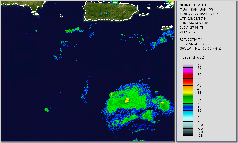
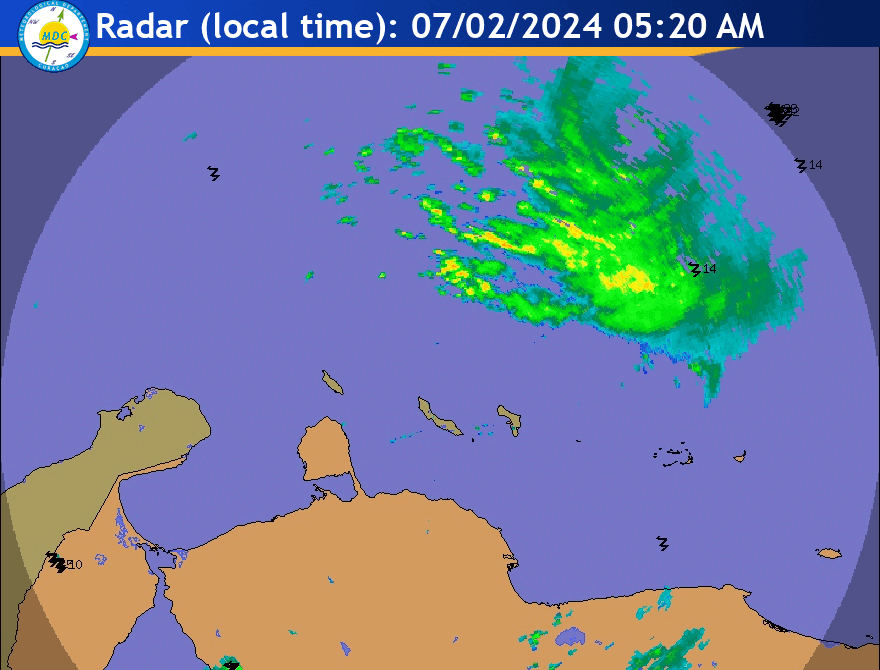
Beryl's eye is visible (though just barely) on Puerto Rico radar and Curacao radar, as per Brian McNoldy's radar loops page. The first two links are auto-updated with the latest imagery. Here are the loops as of writing:
1 likes
TC naming lists: retirements and intensity
Most aggressive Advisory #1's in North Atlantic (cr. kevin for starting the list)
Most aggressive Advisory #1's in North Atlantic (cr. kevin for starting the list)
Who is online
Users browsing this forum: No registered users and 50 guests