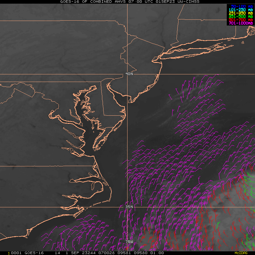
ATL: IDALIA - Post-Tropical - Discussion

Moderator: S2k Moderators

Message
Author
User avatar
TreasureIslandFLGal
S2K Supporter
S2K Supporter
Posts: 1581
Age: 57
Joined: Sun Aug 15, 2004 6:16 pm
Location: Clearwater, Florida ~3 miles from the coast now. We finally moved safely off the barrier island!

Re: ATL: IDALIA - Tropical Storm - Discussion

#1721 Postby TreasureIslandFLGal » Mon Aug 28, 2023 10:03 pm

eastcoastFL wrote:https://tropic.ssec.wisc.edu/real-time/archerOnline/cyclones/2023_10L/web/track.png


3 days of just hanging around. I wonder how bad the weather has been for people living in Cuba and Mexico


My friend in Cancun has said that the weather has been really stuffy for the last few days. Loads of rain and frequent bands coming through at all times vs. their typical summer pattern. He's over it.

.
1 likes   
Chrissy & Ligeia
:flag:

bjackrian
S2K Supporter
S2K Supporter
Posts: 156
Joined: Wed Aug 17, 2005 12:41 pm
Location: Denver, CO

Re: ATL: IDALIA - Tropical Storm - Discussion

#1722 Postby bjackrian » Mon Aug 28, 2023 10:08 pm

I'm curious what people make of the second blob of convection at about 19.5N/85W. Is that "stealing" energy from the CDO or is it unrelated?
0 likes   

User avatar
Teban54
Category 5
Category 5
Posts: 3208
Joined: Sat May 19, 2018 1:19 pm

Re: ATL: IDALIA - Tropical Storm - Discussion

#1723 Postby Teban54 » Mon Aug 28, 2023 10:13 pm

Are the pink pixels on IR showing the developing eyewall?
Image
1 likes   

User avatar
Bocadude85
Category 5
Category 5
Posts: 2991
Age: 38
Joined: Mon Apr 18, 2005 2:20 pm
Location: Honolulu,Hi

Re: ATL: IDALIA - Tropical Storm - Discussion

#1724 Postby Bocadude85 » Mon Aug 28, 2023 10:15 pm

Bocadude85 wrote:Sure seems to be a East of North movement on the Cuban radar, not sure if my eyes are playing tricks on me or what but I’ve been watching that radar for awhile.


Ok so my eyes were not playing tricks on me, she has been moving east of north. Confirmed by the NHC.
1 likes   

User avatar
tropicwatch
Category 5
Category 5
Posts: 3389
Age: 61
Joined: Sat Jun 02, 2007 10:01 am
Location: Panama City Florida
Contact:

Re: ATL: IDALIA - Tropical Storm - Discussion

#1725 Postby tropicwatch » Mon Aug 28, 2023 10:16 pm

Teban54 wrote:Are the pink pixels on IR showing the developing eyewall?
https://i.postimg.cc/QCR2N1v9/goes16-ir-10-L-202308290127.gif


Looks like the center is getting close to where the HH flew north of its center. So maybe they can make a pass through before they head to the barn.
0 likes   
Tropicwatch


Agnes 72', Eloise 75, Elena 85', Kate 85', Charley 86', Florence 88', Beryl 94', Dean 95', Erin 95', Opal 95', Earl 98', Georges 98', Ivan 2004', Arlene 2005', Dennis 2005', Ida 2009' Debby 2012' Irma 2017' Michael 2018'

User avatar
tropicwatch
Category 5
Category 5
Posts: 3389
Age: 61
Joined: Sat Jun 02, 2007 10:01 am
Location: Panama City Florida
Contact:

Re: ATL: IDALIA - Tropical Storm - Discussion

#1726 Postby tropicwatch » Mon Aug 28, 2023 10:18 pm

Nevermind they are ascending and looks like they are headed towards Puerto Rico.
0 likes   
Tropicwatch


Agnes 72', Eloise 75, Elena 85', Kate 85', Charley 86', Florence 88', Beryl 94', Dean 95', Erin 95', Opal 95', Earl 98', Georges 98', Ivan 2004', Arlene 2005', Dennis 2005', Ida 2009' Debby 2012' Irma 2017' Michael 2018'

User avatar
eastcoastFL
Category 5
Category 5
Posts: 3901
Age: 43
Joined: Thu Apr 12, 2007 12:29 pm
Location: Palm City, FL

Re: ATL: IDALIA - Tropical Storm - Discussion

#1727 Postby eastcoastFL » Mon Aug 28, 2023 10:20 pm

Looks like track shifted slightly back to the east at 11pm

Image
1 likes   
Personal Forecast Disclaimer:
The posts in this forum are NOT official forecast and should not be used as such. They are just the opinion of the poster and may or may not be backed by sound meteorological data. They are NOT endorsed by any professional institution or storm2k.org. For official information, please refer to the NHC and NWS products.

Poonwalker
Category 1
Category 1
Posts: 270
Joined: Tue Sep 20, 2022 11:12 am

Re: ATL: IDALIA - Tropical Storm - Discussion

#1728 Postby Poonwalker » Mon Aug 28, 2023 10:21 pm

This is one of those storms where they fly back with sub hurricane wind data and by the time they land the thing blows up with an eye on IR.
3 likes   

User avatar
Jr0d
S2K Supporter
S2K Supporter
Posts: 1409
Joined: Tue Aug 27, 2019 10:52 am
Location: Cayo Hueso

Re: ATL: IDALIA - Tropical Storm - Discussion

#1729 Postby Jr0d » Mon Aug 28, 2023 10:23 pm

Bocadude85 wrote:
Bocadude85 wrote:Sure seems to be a East of North movement on the Cuban radar, not sure if my eyes are playing tricks on me or what but I’ve been watching that radar for awhile.


Ok so my eyes were not playing tricks on me, she has been moving east of north. Confirmed by the NHC.


Tough to tell from Cuba's radar, not enough frames.
http://www.insmet.cu/asp/genesis.asp?TB ... AXw01a.gif

It does seem like land interaction with Cuba could cause an eastern wobble from land interaction and friction pulls the storm right. Doubtful if this is supported by actual meteorological science, however storm centers have done wierd stuff near landmasses
0 likes   

User avatar
eastcoastFL
Category 5
Category 5
Posts: 3901
Age: 43
Joined: Thu Apr 12, 2007 12:29 pm
Location: Palm City, FL

Re: ATL: IDALIA - Tropical Storm - Discussion

#1730 Postby eastcoastFL » Mon Aug 28, 2023 10:24 pm

It’s sure become a lot more symmetrical throughout the day and ya it’s also back to the east of 85W

Image
0 likes   
Personal Forecast Disclaimer:
The posts in this forum are NOT official forecast and should not be used as such. They are just the opinion of the poster and may or may not be backed by sound meteorological data. They are NOT endorsed by any professional institution or storm2k.org. For official information, please refer to the NHC and NWS products.

User avatar
tropicwatch
Category 5
Category 5
Posts: 3389
Age: 61
Joined: Sat Jun 02, 2007 10:01 am
Location: Panama City Florida
Contact:

Re: ATL: IDALIA - Tropical Storm - Discussion

#1731 Postby tropicwatch » Mon Aug 28, 2023 10:24 pm

Poonwalker wrote:This is one of those storms where they fly back with sub hurricane wind data and by the time they land the thing blows up with an eye on IR.

The next scheduled AF flight is scheduled to take off around 4:30am CDT.
0 likes   
Tropicwatch


Agnes 72', Eloise 75, Elena 85', Kate 85', Charley 86', Florence 88', Beryl 94', Dean 95', Erin 95', Opal 95', Earl 98', Georges 98', Ivan 2004', Arlene 2005', Dennis 2005', Ida 2009' Debby 2012' Irma 2017' Michael 2018'

User avatar
cycloneye
Admin
Admin
Posts: 145459
Age: 68
Joined: Thu Oct 10, 2002 10:54 am
Location: San Juan, Puerto Rico

Re: ATL: IDALIA - Tropical Storm - Discussion

#1732 Postby cycloneye » Mon Aug 28, 2023 10:25 pm

0 likes   
Visit the Caribbean-Central America Weather Thread where you can find at first post web cams,radars
and observations from Caribbean basin members Click Here

User avatar
Bocadude85
Category 5
Category 5
Posts: 2991
Age: 38
Joined: Mon Apr 18, 2005 2:20 pm
Location: Honolulu,Hi

Re: ATL: IDALIA - Tropical Storm - Discussion

#1733 Postby Bocadude85 » Mon Aug 28, 2023 10:32 pm

Jr0d wrote:
Bocadude85 wrote:
Bocadude85 wrote:Sure seems to be a East of North movement on the Cuban radar, not sure if my eyes are playing tricks on me or what but I’ve been watching that radar for awhile.


Ok so my eyes were not playing tricks on me, she has been moving east of north. Confirmed by the NHC.


Tough to tell from Cuba's radar, not enough frames.
http://www.insmet.cu/asp/genesis.asp?TB ... AXw01a.gif

It does seem like land interaction with Cuba could cause an eastern wobble from land interaction and friction pulls the storm right. Doubtful if this is supported by actual meteorological science, however storm centers have done wierd stuff near landmasses


NHC confirmed the east of north movement in the latest discussion.

WTNT45 KNHC 290258
TCDAT5

Tropical Storm Idalia Discussion Number 10
NWS National Hurricane Center Miami FL AL102023
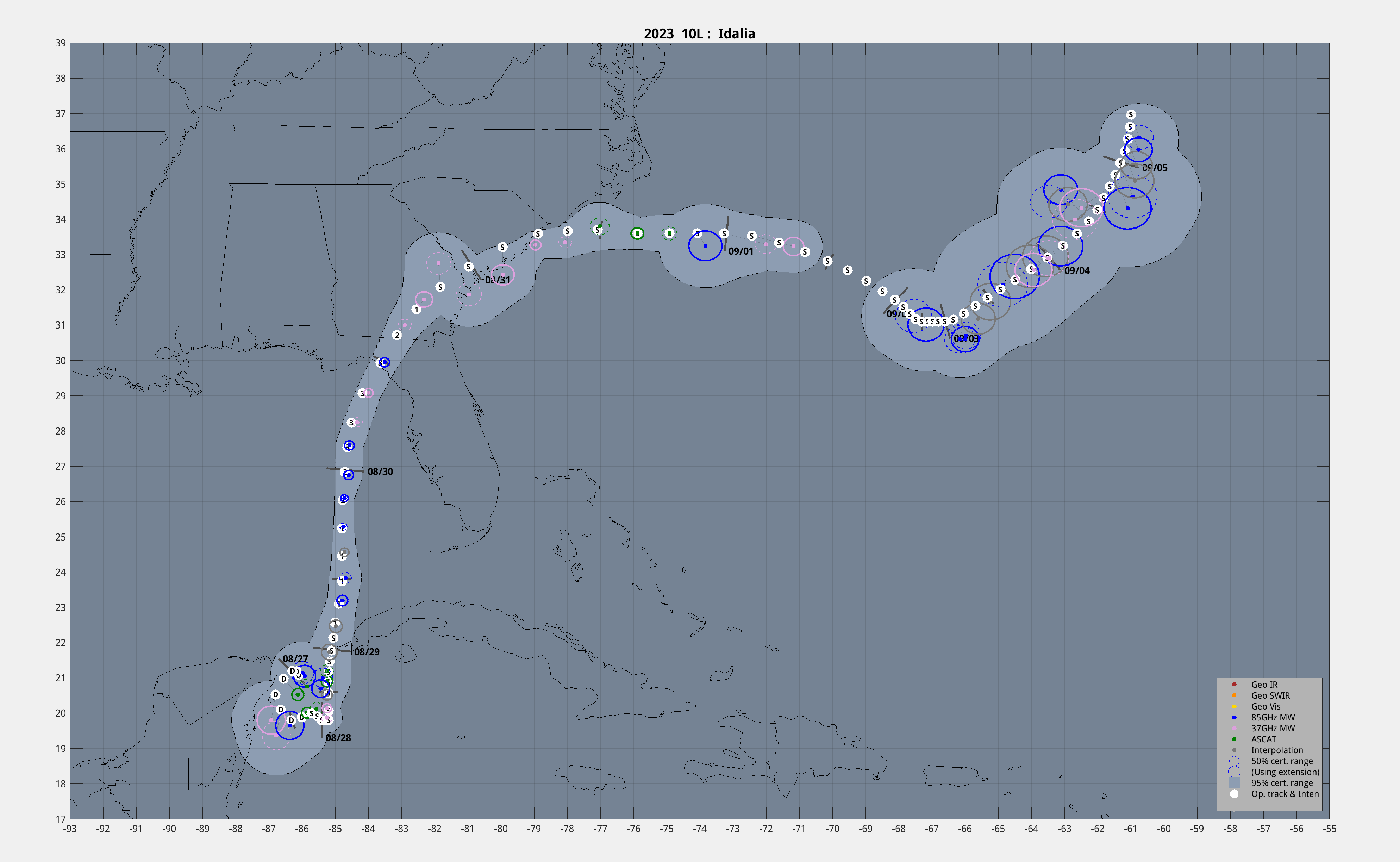
1000 PM CDT Mon Aug 28 2023

The system has moved a bit slower than earlier today with an initial motion estimate of just slightly east of due north at around 7 kt. Idalia should be steered northward along the western side of a mid-level ridge and then turn north-northeastward due to a trough to its northwest. This track will take the center across the northeastern Gulf coast on Wednesday morning, and over northern Florida and southeastern Georgia thereafter. In 2 to 3 days, a mid-tropospheric trough moving off the eastern U.S. coast will likely cause the tropical cyclone to turn northeastward to eastward off the coast of the Carolinas. The official track forecast for this advisory is essentially the same as the previous one. This is near the middle of the track guidance, which are fairly tightly clustered, with the GFS on the left side and the ECMWF on the right side.
0 likes   

User avatar
FLpanhandle91
Category 5
Category 5
Posts: 1033
Age: 34
Joined: Mon Sep 13, 2010 3:50 pm
Location: Fort Walton Beach, FL

Re: ATL: IDALIA - Tropical Storm - Discussion

#1734 Postby FLpanhandle91 » Mon Aug 28, 2023 10:33 pm

Robust northern eyewall has formed and is visible from IR and radar. This has now moved off the northern coast of Cuba.

Image

AF recon looks to be making a pass since the center is offshore.
5 likes   

User avatar
tropicwatch
Category 5
Category 5
Posts: 3389
Age: 61
Joined: Sat Jun 02, 2007 10:01 am
Location: Panama City Florida
Contact:

Re: ATL: IDALIA - Tropical Storm - Discussion

#1735 Postby tropicwatch » Mon Aug 28, 2023 10:37 pm

FLpanhandle91 wrote:Robust northern eyewall has formed and is visible from IR and radar. This has now moved off the northern coast of Cuba.

https://i.imgur.com/XLmc22R.jpg

AF recon looks to be making a pass since the center is offshore.


Surprised they turned around.
0 likes   
Tropicwatch


Agnes 72', Eloise 75, Elena 85', Kate 85', Charley 86', Florence 88', Beryl 94', Dean 95', Erin 95', Opal 95', Earl 98', Georges 98', Ivan 2004', Arlene 2005', Dennis 2005', Ida 2009' Debby 2012' Irma 2017' Michael 2018'

User avatar
chaser1
S2K Supporter
S2K Supporter
Posts: 5475
Age: 64
Joined: Sat Oct 15, 2005 5:59 pm
Location: Longwood, Fl

Re: ATL: IDALIA - Tropical Storm - Discussion

#1736 Postby chaser1 » Mon Aug 28, 2023 10:38 pm

Teban54 wrote:Are the pink pixels on IR showing the developing eyewall?
https://i.postimg.cc/QCR2N1v9/goes16-ir-10-L-202308290127.gif


I had mistakenly thought the same thing. At least with this particular storm, it appears that these uber-cold cloud tops merely represent the highest/coldest tops essentially being exhausted out to the southeast in part due to the westerly shear hampering the storm. Whats interesting to me is, while this itself does not necessarily represent true forward motion of the storm, it does perhaps point to the location of the mid to upper level tilted well to the right of the LLC. Whats interesting to me is that I would perceive that greater northeast tilt to at least induce the LLC to pull itself under and it is that function that may be responsible for the slighr east of north motion we have been noticing. Honestly if I were folks in Tampa, i'd probably be rooting for this storm to get its act together as quick as possible. I can only see any ongoing misalignment as a result of (upper OR undercutting) shear as a potential cause for Idalia's track to "lean" more to the right. The last thing that the broad Tampa Bay region want to see is any track that might bring a major hurricane wind and storm surge threat closer to their coastline.
3 likes   
Andy D

(For official information, please refer to the NHC and NWS products.)

User avatar
TreasureIslandFLGal
S2K Supporter
S2K Supporter
Posts: 1581
Age: 57
Joined: Sun Aug 15, 2004 6:16 pm
Location: Clearwater, Florida ~3 miles from the coast now. We finally moved safely off the barrier island!

Re: ATL: IDALIA - Tropical Storm - Discussion

#1737 Postby TreasureIslandFLGal » Mon Aug 28, 2023 10:41 pm

How long do we have to wait for the model runs that will include all of the synoptic flight samplings that they were getting earlier tonight? Really interested in seeing those, along with a proper initialization!
0 likes   
Chrissy & Ligeia
:flag:

PavelGaborik10
Category 1
Category 1
Posts: 455
Joined: Tue Sep 04, 2018 3:23 pm

Re: ATL: IDALIA - Tropical Storm - Discussion

#1738 Postby PavelGaborik10 » Mon Aug 28, 2023 10:44 pm

Core is coming together nicely these last couple of hours, convective burst also sticking around, outflow improving.

Shear is beginning to lessen.
0 likes   

IcyTundra
Category 5
Category 5
Posts: 1205
Joined: Mon Jun 07, 2021 9:32 pm
Location: Dickinson, Texas

Re: ATL: IDALIA - Tropical Storm - Discussion

#1739 Postby IcyTundra » Mon Aug 28, 2023 10:44 pm

TreasureIslandFLGal wrote:How long do we have to wait for the model runs that will include all of the synoptic flight samplings that they were getting earlier tonight? Really interested in seeing those, along with a proper initialization!


06Z runs should have the latest recon data from the plane currently in the storm right now.
1 likes   

Hugo1989
Tropical Storm
Tropical Storm
Posts: 147
Joined: Mon Jun 14, 2010 9:09 am

Re: ATL: IDALIA - Tropical Storm - Discussion

#1740 Postby Hugo1989 » Mon Aug 28, 2023 10:45 pm

Special advisory in the next hour or so? What you’ll think?
0 likes   


Return to “2023”

Who is online

Users browsing this forum: No registered users and 2 guests