Low Pressure in Gulf of Mexico

This is the general tropical discussion area. Anyone can take their shot at predicting a storms path.

Moderator: S2k Moderators

Forum rules

The posts in this forum are NOT official forecasts and should not be used as such. They are just the opinion of the poster and may or may not be backed by sound meteorological data. They are NOT endorsed by any professional institution or STORM2K. For official information, please refer to products from the National Hurricane Center and National Weather Service.

Help Support Storm2K
Message
Author
User avatar
TropicalWXMA
Tropical Storm
Tropical Storm
Posts: 114
Joined: Wed May 18, 2005 9:22 pm
Location: Boston, MA
Contact:

Re: Low Pressure at Eastern Gulf of Mexico / Model runs

#181 Postby TropicalWXMA » Wed May 20, 2009 8:24 pm

CMC:
Image

GFS:
Image

CMC:
Image

GFS:
Image
0 likes   

User avatar
HURAKAN
Professional-Met
Professional-Met
Posts: 46086
Age: 38
Joined: Thu May 20, 2004 4:34 pm
Location: Key West, FL
Contact:

#182 Postby HURAKAN » Wed May 20, 2009 10:30 pm

Image
0 likes   

User avatar
ROCK
Category 5
Category 5
Posts: 9484
Age: 54
Joined: Tue Aug 17, 2004 7:30 am
Location: Kemah, Texas

Re: Low Pressure at Eastern Gulf of Mexico

#183 Postby ROCK » Wed May 20, 2009 11:06 pm

looks like the low is trending a more westward solution in the latest GFS run, NOGAPS has followed suit. Let see if the Euro jumps tonight...
0 likes   

User avatar
MGC
S2K Supporter
S2K Supporter
Posts: 5899
Joined: Sun Mar 23, 2003 9:05 pm
Location: Pass Christian MS, or what is left.

Re: Low Pressure at Eastern Gulf of Mexico

#184 Postby MGC » Wed May 20, 2009 11:57 pm

Very limited convection near the low centers tonight....dry air abounds. Little chance if any of development......MGC
0 likes   

User avatar
tailgater
S2K Supporter
S2K Supporter
Posts: 3339
Joined: Sun Jul 11, 2004 9:13 pm
Location: St. Amant La.

Re: Low Pressure at Eastern Gulf of Mexico

#185 Postby tailgater » Thu May 21, 2009 3:23 am

Conditions at 42003 as of
(2:50 am CDT)
0750 GMT on 05/21/2009: Unit of Measure: English Metric Time Zone: Station Local Time Greenwich Mean Time [GMT] British Summer Time [GMT+1] Eastern Greenland [GMT-1] Azores [GMT-2] Western Greenland [GMT-3] Atlantic Standard [GMT-4] US/Eastern Standard US/Central Standard US/Mountain Standard US/Pacific Standard Alaska Standard [GMT-9] Hawaii-Aleutian Standard [GMT-10] Samoa Standard [GMT-11] International Date Line West [GMT-12] Western European [GMT+0] Central European [GMT+1] Eastern European [GMT+2] Moscow [GMT+3] USSR Zone 3 [GMT+4] USSR Zone 4 [GMT+5] USSR Zone 5 [GMT+6] USSR Zone 6 [GMT+7] China Coast [GMT+8] Japan Standard [GMT+9] Guam Standard [GMT+10] GMT+11 International Date Line East [GMT+12]
Click on the graph icon in the table below to see a time series plot of the last five days of that observation.

Wind Direction (WDIR): ESE ( 110 deg true )
Wind Speed (WSPD): 6.0 m/s
Wind Gust (GST): 7.0 m/s
Wave Height (WVHT): 2.2 m
Dominant Wave Period (DPD): 8 sec
Average Period (APD): 6.5 sec
Mean Wave Direction (MWD): N ( 10 deg true )
Atmospheric Pressure (PRES): 1005.9 mb
Pressure Tendency (PTDY): -1.4 mb ( Falling )

Air Temperature (ATMP): 24.0 °C
Water Temperature (WTMP): 26.6 °C
Dew Point (DEWP): 23.9 °C
0 likes   

User avatar
HURAKAN
Professional-Met
Professional-Met
Posts: 46086
Age: 38
Joined: Thu May 20, 2004 4:34 pm
Location: Key West, FL
Contact:

Re: Low Pressure in Gulf of Mexico

#186 Postby HURAKAN » Thu May 21, 2009 6:53 am

Image
0 likes   

User avatar
HURAKAN
Professional-Met
Professional-Met
Posts: 46086
Age: 38
Joined: Thu May 20, 2004 4:34 pm
Location: Key West, FL
Contact:

#187 Postby HURAKAN » Thu May 21, 2009 7:26 am

Image

Nothing close to a tropical or subtropical storm but I have to say that it has improved.
0 likes   

User avatar
Evil Jeremy
S2K Supporter
S2K Supporter
Posts: 5463
Age: 32
Joined: Mon Apr 10, 2006 2:10 pm
Location: Los Angeles, CA

Re: Low Pressure in Gulf of Mexico

#188 Postby Evil Jeremy » Thu May 21, 2009 7:28 am

If this system continues on this track, I would not be surprised to see this Invested by the end of the week or early weekend.
0 likes   

User avatar
cycloneye
Admin
Admin
Posts: 145631
Age: 68
Joined: Thu Oct 10, 2002 10:54 am
Location: San Juan, Puerto Rico

Re: Low Pressure in Gulf of Mexico

#189 Postby cycloneye » Thu May 21, 2009 7:37 am

You want a more closeup pic?

Image
0 likes   

User avatar
Evil Jeremy
S2K Supporter
S2K Supporter
Posts: 5463
Age: 32
Joined: Mon Apr 10, 2006 2:10 pm
Location: Los Angeles, CA

Re: Low Pressure in Gulf of Mexico

#190 Postby Evil Jeremy » Thu May 21, 2009 8:00 am

So now there is a giant line of rain with this system that is hugging the Florida (east) coastline. As this system moves west, will it drag all that rain over (S)FL?
0 likes   

User avatar
cycloneye
Admin
Admin
Posts: 145631
Age: 68
Joined: Thu Oct 10, 2002 10:54 am
Location: San Juan, Puerto Rico

Re: Low Pressure in Gulf of Mexico

#191 Postby cycloneye » Thu May 21, 2009 8:56 am

Dr Jeff Masters latest update=Low more organized

Gulf of Mexico low growing more organized


Posted by: JeffMasters, 1:51 PM GMT on May 21, 2009

The large extratropical storm that has been drenching Florida over the past few days continues to pour rain on the state as it treks slowly west-northwestward over the Gulf of Mexico. Rainfall amounts as high as 23.75 inches have been measured in Northern Florida at the Flagler County Fairgrounds over the past four days, and Daytona Beach has seen over 14 inches, forcing closure of numerous roads. Another 1 - 3 inches are expected in Northeast Florida today from the storm, along with beach erosion, 7 - 10 foot waves, and tides 2 - 3 feet above normal. The bad weather in Northeast Florida should gradually subside Friday and the rains should diminish substantially on Saturday, when the center of the storm is expected to move ashore over Louisiana.

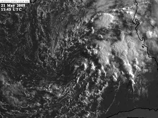
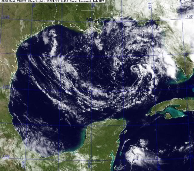
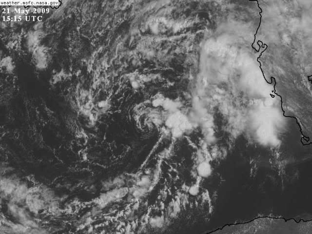
Latest visible satellite loops show that the circulation of the low has grown more circular and better defined, and heavy thunderstorm activity is starting to build off the Gulf Coast of Florida on the low's east side. These thunderstorms are beginning to form spiral bands characteristic of a developing tropical depression. Water vapor satellite imagery shows that the low is moving into an area of dry continental air, though, and this dry air will slow development. Wind shear is about 20 knots, which is low enough to allow development. While none of the computer models develop the storm, they generally predict the storm should move northwestwards towards Louisiana over the next two days, and the shear is lower to the north. The low is currently over Sea Surface Temperatures (SSTs) of about 27°C in the Loop Current, which is about 1°C (1.8°F) warmer than average. SSTs of at least 26°C are typically needed to support a tropical storm, so I expect the low will continue to develop through Friday. By Friday night, the low will be approaching the Louisiana coast, and SSTs will cool to 26°C. Still, with wind shear expected to drop, this low has a medium (30 - 50%) chance of developing into a subtropical or tropical depression before its expected landfall Saturday over Louisiana. Since there will be strong winds from the west creating wind shear over the storm, plus dry air to the storm's west, most of the heavy rain should be confined to the east of the storm's center, along a stretch of coast from New Orleans to Pensacola. Rainfall totals of 3 - 6 inches can be expected.
0 likes   

User avatar
BigA
Professional-Met
Professional-Met
Posts: 1317
Joined: Sun Jul 24, 2005 10:56 pm

Re: Low Pressure in Gulf of Mexico

#192 Postby BigA » Thu May 21, 2009 9:07 am

This little guy certainly has a well-defined circulation, though still a paucity of convection. Won't be surprised to see it make a run at subtropical status in the next 48 hours.
0 likes   

Stormcenter
S2K Supporter
S2K Supporter
Posts: 6684
Joined: Wed Sep 03, 2003 11:27 am
Location: Houston, TX

Re: Low Pressure in Gulf of Mexico

#193 Postby Stormcenter » Thu May 21, 2009 9:14 am

I'm not impressed but hey it's still May so it should be expected.
As I said several days ago a sub-tropical depression (maybe storm) is not out of the
question but anything else is extremely unlikely.
Last edited by Stormcenter on Thu May 21, 2009 10:06 am, edited 1 time in total.
0 likes   

User avatar
HURAKAN
Professional-Met
Professional-Met
Posts: 46086
Age: 38
Joined: Thu May 20, 2004 4:34 pm
Location: Key West, FL
Contact:

#194 Postby HURAKAN » Thu May 21, 2009 9:55 am

0 likes   

Aric Dunn
Category 5
Category 5
Posts: 21238
Age: 42
Joined: Sun Sep 19, 2004 9:58 pm
Location: Ready for the Chase.
Contact:

#195 Postby Aric Dunn » Thu May 21, 2009 10:10 am

yeah has a much better appearance this morning ... lot of dry air but compared to the other day its moderated a lot and continues to so ..will see what happens.. interesting to note the convection is trying to build closer to the center.
0 likes   

User avatar
HURAKAN
Professional-Met
Professional-Met
Posts: 46086
Age: 38
Joined: Thu May 20, 2004 4:34 pm
Location: Key West, FL
Contact:

#196 Postby HURAKAN » Thu May 21, 2009 10:14 am

0 likes   

User avatar
HURAKAN
Professional-Met
Professional-Met
Posts: 46086
Age: 38
Joined: Thu May 20, 2004 4:34 pm
Location: Key West, FL
Contact:

#197 Postby HURAKAN » Thu May 21, 2009 10:36 am

Image
0 likes   

Stormcenter
S2K Supporter
S2K Supporter
Posts: 6684
Joined: Wed Sep 03, 2003 11:27 am
Location: Houston, TX

Re: Low Pressure in Gulf of Mexico

#198 Postby Stormcenter » Thu May 21, 2009 10:41 am

To my untrained eye it looks like its maybe taken a slight more
west-northerwestly track and just drifting. I know we all see things differently
but it really doesn't "look" that much better then yesterday. There
is still no deep convection around the "center" area. JMHO

http://www.ssd.noaa.gov/goes/east/gmex/loop-avn.html

http://www.ssd.noaa.gov/goes/east/gmex/loop-vis.html
0 likes   

User avatar
boca
Category 5
Category 5
Posts: 6368
Age: 60
Joined: Mon Dec 15, 2003 8:49 am
Location: Boca Raton,FL

Re: Low Pressure in Gulf of Mexico

#199 Postby boca » Thu May 21, 2009 10:43 am

As this system moves farther west I'm wondering if that heavy band of rain over the Bahamas will shift west in tantem with this slow moving low causing more rain in S FL.
0 likes   

Ed Mahmoud

Re: Low Pressure in Gulf of Mexico

#200 Postby Ed Mahmoud » Thu May 21, 2009 11:00 am

0 likes   


Return to “Talkin' Tropics”

Who is online

Users browsing this forum: jconsor, Ulf and 55 guests