WPAC: UTOR - Post-Tropical

Moderator: S2k Moderators

Message
Author
vrif
Category 1
Category 1
Posts: 282
Joined: Sun Jun 09, 2013 10:51 pm

Re: WPAC: UTOR - Typhoon (Labuyo PAGASA)

#181 Postby vrif » Sat Aug 10, 2013 8:41 pm

Image

WTPQ20 RJTD 110000
RSMC TROPICAL CYCLONE ADVISORY
NAME TY 1311 UTOR (1311)
ANALYSIS
PSTN 110000UTC 14.5N 125.9E GOOD
MOVE WNW 11KT
PRES 955HPA
MXWD 080KT
GUST 115KT
50KT 70NM
30KT 150NM
FORECAST
24HF 120000UTC 16.9N 122.1E 75NM 70%
MOVE WNW 12KT
PRES 940HPA
MXWD 085KT
GUST 120KT
48HF 130000UTC 19.1N 117.8E 140NM 70%
MOVE WNW 12KT
PRES 945HPA
MXWD 085KT
GUST 120KT
72HF 140000UTC 20.9N 113.8E 160NM 70%
MOVE WNW 10KT
PRES 940HPA
MXWD 085KT
GUST 120KT =
0 likes   

Alyono
Professional-Met
Professional-Met
Posts: 6961
Joined: Fri Apr 26, 2013 3:52 pm
Location: Texas Coast

#182 Postby Alyono » Sat Aug 10, 2013 8:45 pm

JMA track STILL well north. They keep forecasting an immediate turn and that turn is not happening
0 likes   

vrif
Category 1
Category 1
Posts: 282
Joined: Sun Jun 09, 2013 10:51 pm

Re: WPAC: UTOR - Typhoon (Labuyo PAGASA)

#183 Postby vrif » Sat Aug 10, 2013 9:01 pm

Image
0 likes   

User avatar
xtyphooncyclonex
Category 5
Category 5
Posts: 3861
Age: 23
Joined: Sat Dec 08, 2012 9:07 am
Location: Cebu City
Contact:

#184 Postby xtyphooncyclonex » Sat Aug 10, 2013 9:05 pm

Upgraded to Category 3, same strength as 2006's Typhoon Utor.

But the ACE Level:
Western Pacific
37.28 [Normal: 92]

We're still very far, but we're catching up faster!
UTOR - 100 kts (185.2 km/h) - 3.5475
0 likes   
REMINDER: My opinions that I, or any other NON Pro-Met in this forum, are unofficial. Please do not take my opinions as an official forecast and warning. I am NOT a meteorologist. Following my forecasts blindly may lead to false alarm, danger and risk if official forecasts from agencies are ignored.

Typhoon Hunter
WesternPacificWeather.com
Posts: 1221
Joined: Wed Oct 11, 2006 11:37 am
Location: Tokyo
Contact:

Re:

#185 Postby Typhoon Hunter » Sat Aug 10, 2013 9:18 pm

Alyono wrote:JMA track STILL well north. They keep forecasting an immediate turn and that turn is not happening


Looks like it's started to gain some latitude over the last 2 hours per visible MTSAT imagery on CWB website. We'll need to wait a few more hours to see if this is the turn or just a temporary jog.
0 likes   
James - Documenting tropical cyclones...

http://www.youtube.com/TyphoonHunter

vrif
Category 1
Category 1
Posts: 282
Joined: Sun Jun 09, 2013 10:51 pm

Re: WPAC: UTOR - Typhoon (Labuyo PAGASA)

#186 Postby vrif » Sat Aug 10, 2013 9:38 pm

HKO's newest track, favouring a hook to the north like most agencies are predicting.

Image

Forecast Positions and Intensities
Date time Position Classification Maximum sustained wind near centre
08:00 HKT 12 August 2013 16.4 N 122.6 E Severe Typhoon 175 km/h
08:00 HKT 13 August 2013 18.8 N 116.8 E Typhoon 140 km/h
08:00 HKT 14 August 2013 19.8 N 113.3 E Typhoon 145 km/h
0 likes   

RobWESTPACWX
WestPACMet
WestPACMet
Posts: 1616
Joined: Fri Sep 17, 2010 2:26 am
Location: Tokyo, Japan
Contact:

#187 Postby RobWESTPACWX » Sat Aug 10, 2013 9:46 pm

Hey all, James and I will be doing a live cast in 10min

you can watch and comment if you want at this link

http://www.westernpacificweather.com/cu ... orm-track/

or on youtube

http://www.youtube.com/watch?v=aFmqo_rg ... e=youtu.be
0 likes   
Satellites, Charts and Forecasting tools for East Asia at WESTERNPACIFICWEATHER.COM

oaba09
S2K Supporter
S2K Supporter
Posts: 1496
Age: 38
Joined: Thu Oct 01, 2009 10:02 am
Location: Valenzuela, Philippines
Contact:

WPAC: UTOR - Typhoon (Labuyo PAGASA)

#188 Postby oaba09 » Sat Aug 10, 2013 9:56 pm

The finals between the philippines and iran is later tonight...I hope we don't lose electricity....not looking good though since Im up north right now(nueva ecija)


Sent from my iPad mini using Tapatalk
0 likes   

oaba09
S2K Supporter
S2K Supporter
Posts: 1496
Age: 38
Joined: Thu Oct 01, 2009 10:02 am
Location: Valenzuela, Philippines
Contact:

WPAC: UTOR - Typhoon (Labuyo PAGASA)

#189 Postby oaba09 » Sat Aug 10, 2013 9:56 pm

The finals between the philippines and iran is later tonight...I hope we don't lose electricity....not looking good though since Im up north right now(nueva ecija)


Sent from my iPad mini using Tapatalk
0 likes   

Alyono
Professional-Met
Professional-Met
Posts: 6961
Joined: Fri Apr 26, 2013 3:52 pm
Location: Texas Coast

Re: Re:

#190 Postby Alyono » Sat Aug 10, 2013 9:58 pm

Typhoon Hunter wrote:
Alyono wrote:JMA track STILL well north. They keep forecasting an immediate turn and that turn is not happening


Looks like it's started to gain some latitude over the last 2 hours per visible MTSAT imagery on CWB website. We'll need to wait a few more hours to see if this is the turn or just a temporary jog.


even with the turn, its still a bit south of their forecasts
0 likes   

User avatar
xtyphooncyclonex
Category 5
Category 5
Posts: 3861
Age: 23
Joined: Sat Dec 08, 2012 9:07 am
Location: Cebu City
Contact:

Re: WPAC: UTOR - Typhoon (Labuyo PAGASA)

#191 Postby xtyphooncyclonex » Sat Aug 10, 2013 10:02 pm

UTOR really looking impressive as of now.

Image
0 likes   
REMINDER: My opinions that I, or any other NON Pro-Met in this forum, are unofficial. Please do not take my opinions as an official forecast and warning. I am NOT a meteorologist. Following my forecasts blindly may lead to false alarm, danger and risk if official forecasts from agencies are ignored.

euro6208

Re: WPAC: UTOR - Typhoon (Labuyo PAGASA)

#192 Postby euro6208 » Sat Aug 10, 2013 10:03 pm

100 knots seems reasonable...However, given the small size of the eye (pinhole), i suspect this is a bit stronger than indicated...Dvorak ALWAYS have a hard time with powerful storms especially with small eyes...

Current Intensity is probrably somewhere in the neighborhood of 125-150 knots...


The posts in this forum are NOT official forecast and should not be used as such. They are just the opinion of the poster and may or may not be backed by sound meteorological data. They are NOT endorsed by any professional institution or storm2k.org. For official information, please refer to the JTWC and JMA products.
0 likes   

euro6208

Re: WPAC: UTOR - Typhoon (Labuyo PAGASA)

#193 Postby euro6208 » Sat Aug 10, 2013 10:08 pm

WDPN31 PGTW 110300
MSGID/GENADMIN/JOINT TYPHOON WRNCEN PEARL HARBOR HI//
SUBJ/PROGNOSTIC REASONING FOR TYPHOON 11W (UTOR) WARNING NR 10//
RMKS//
1. FOR METEOROLOGISTS.
2. 6 HOUR SUMMARY AND ANALYSIS.
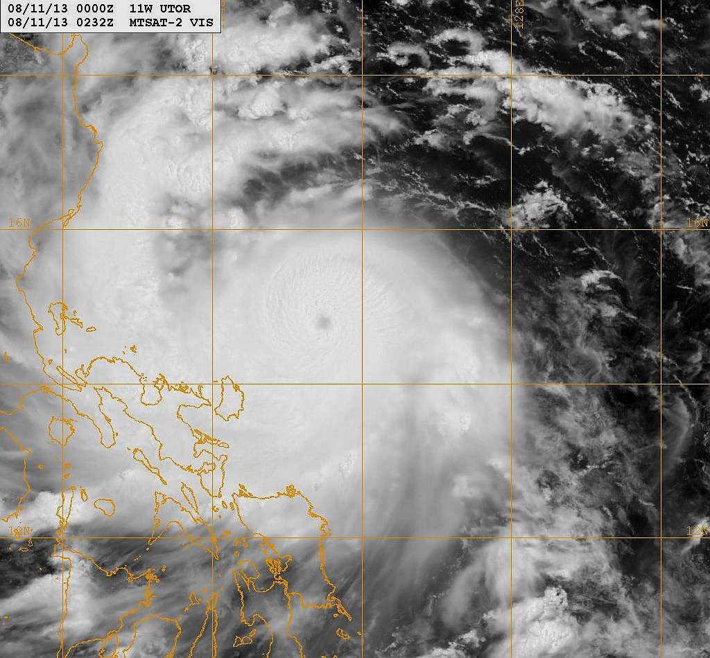
TYPHOON 11W (UTOR), LOCATED APPROXIMATELY 285 NM EASTWARD OF
MANILA, PHILIPPINES, HAS TRACKED WESTWARD AT 12 KNOTS OVER THE PAST
SIX HOURS. ANIMATED MULTISPECTRAL SATELLITE IMAGERY (MSI) DEPICTS A
STEADY EXPANSION OF THE CENTRAL CONVECTION OVER THE PAST SIX HOURS,
AS WELL AS WHAT APPEARS TO BE A RE-FORMATION OF THE PIN-HOLE EYE.
THE CURRENT POSITION IS BASED ON THE AFOREMENTIONED MSI AND POSITION
FIXES FROM PGTW AND RJTD WITH HIGH CONFIDENCE. THE CURRENT
INTENSITY IS ASSESSED AT 100 KNOTS, BASED ON THE PGTW DVORAK
ESTIMATE OF 102 KNOTS, AND TAKING INTO ACCOUNT THE IMPROVEMENT IN
THE SATELLITE PRESENTATION. UPPER LEVEL ANALYSIS INDICATES TY 11W
REMAINS IN A FAVORABLE ENVIRONMENT, WITH DIFFLUENCE ALOFT, LOW TO
MODERATE (10-15 KNOTS) VERTICAL WIND SHEAR (VWS), AND GOOD RADIAL
OUTFLOW WHICH IS BEING ENHANCED THROUGH INTERACTION WITH A TROPICAL
UPPER TROPOSPHERIC TROUGH (TUTT) CELL TO THE NORTHWEST. TY 11W IS
TRACKING WESTWARD ALONG THE SOUTHERN PERIPHERY OF A SUBTROPICAL
RIDGE (STR) TO THE NORTH.
3. FORECAST REASONING.
A. THERE IS NO CHANGE TO THE FORECAST PHILOSOPHY SINCE THE
PREVIOUS PROGNOSTIC REASONING MESSAGE.
B. TY 11W WILL CONTINUE TRACKING WESTWARD TO WEST-NORTHWESTWARD
ALONG THE SOUTHERN PERIPHERY OF THE CURRENT STEERING RIDGE THROUGH
TAU 72. GIVEN THE FAVORABLE ENVIRONMENT, STEADY INTENSIFICATION TO A
PEAK NEAR 110 KNOTS IS FORECAST FOR THE NEXT APPROXIMATELY 18 HOURS,
PRIOR TO LANDFALL OVER LUZON. WHILE TRACKING OVER LUZON, TERRAIN AND
FRICTIONAL EFFECTS WILL WEAKEN THE SYSTEM CONSIDERABLY. ONCE TY 11W
RE-EMERGES IN THE SOUTH CHINA SEA, GENERALLY FAVORABLE CONDITIONS
SHOULD ALLOW FOR GRADUAL RE-INTENSIFICATION THROUGH TAU 72.
DYNAMICAL MODELS REMAIN IN GOOD AGREEMENT THROUGH TAU 72, WITH THE
EXCEPTION OF THE JAPANESE ENSEMBLE MEAN WHICH IS A SIGNIFICANT
EASTWARD OUTLIER. THE CURRENT FORECAST LIES CLOSE TO THE MULTI-MODEL
CONSENSUS AND PRIOR FORECASTS. GIVEN A STRAIGHTFORWARD STEERING
ENVIRONMENT AND GOOD MODEL AGREEMENT, FORECAST TRACK CONFIDENCE IS
HIGH IN THE NEAR TO MEDIUM TERM.
C. IN THE EXTENDED PERIOD, DYNAMICAL MODELS HAVE COME INTO MUCH
BETTER AGREEMENT ON A MORE WESTWARD TRACK, CONSISTENT WITH JTWC
TRACK FORECAST PHILOSOPHY. WITH THE EXCEPTION OF THE JAPANESE
ENSEMBLE MEAN, THE DYNAMICAL MODELS INDICATE THAT THE APPROACHING
SHORTWAVE TROUGH WILL NOT SIGNIFICANTLY ALTER THE STRENGTH OR
ORIENTATION OF THE STEERING STR. THE JTWC FORECAST LIES SLIGHTLY
EQUATORWARD OF THE MULTI-MODEL CONSENSUS IN THE EXTENDED PERIOD TO
OFFSET THE IMPACT OF THE OUTLIER ON THE CONSENSUS, AND IS LAID
ALMOST DIRECTLY OVER THE PREVIOUS FORECAST TRACK. AROUND TAU 72,
DECREASING SEA SURFACE TEMPERATURES AND INCREASING VWS WILL BEGIN TO
WEAKEN THE SYSTEM OVER WATER, WITH RAPID DISSIPATION AFTER LANDFALL
OVER SOUTHERN CHINA. DUE TO IMPROVED AGREEMENT AMONG THE JTWC
CONSENSUS MODELS, FORECAST TRACK CONFIDENCE IN THE TAU 72 TO 120
PERIOD IS NOW HIGH.//
NNNN
0 likes   

User avatar
xtyphooncyclonex
Category 5
Category 5
Posts: 3861
Age: 23
Joined: Sat Dec 08, 2012 9:07 am
Location: Cebu City
Contact:

Re: WPAC: UTOR - Typhoon (Labuyo PAGASA)

#194 Postby xtyphooncyclonex » Sat Aug 10, 2013 10:09 pm

euro6208 wrote:100 knots seems reasonable...However, given the small size of the eye (pinhole), i suspect this is a bit stronger than indicated...Dvorak ALWAYS have a hard time with powerful storms especially with small eyes...

Current Intensity is probrably somewhere in the neighborhood of 125-150 knots...


The posts in this forum are NOT official forecast and should not be used as such. They are just the opinion of the poster and may or may not be backed by sound meteorological data. They are NOT endorsed by any professional institution or storm2k.org. For official information, please refer to the JTWC and JMA products.

I agree, but 125-150 kts is too strong. I think this is about 115 kts.

The posts in this forum are NOT official forecast and should not be used as such. They are just the opinion of the poster and may or may not be backed by sound meteorological data. They are NOT endorsed by any professional institution or storm2k.org. For official information, please refer to the JTWC and JMA products.
0 likes   
REMINDER: My opinions that I, or any other NON Pro-Met in this forum, are unofficial. Please do not take my opinions as an official forecast and warning. I am NOT a meteorologist. Following my forecasts blindly may lead to false alarm, danger and risk if official forecasts from agencies are ignored.

User avatar
senorpepr
Military Met/Moderator
Posts: 12542
Age: 43
Joined: Fri Aug 22, 2003 9:22 pm
Location: Mackenbach, Germany
Contact:

#195 Postby senorpepr » Sat Aug 10, 2013 10:14 pm

Sunday morning video update:
[youtube]http://www.youtube.com/watch?v=r8tUNcLCdfI[/youtube]
0 likes   

tolakram
Admin
Admin
Posts: 20009
Age: 62
Joined: Sun Aug 27, 2006 8:23 pm
Location: Florence, KY (name is Mark)

Re: WPAC: UTOR - Typhoon (Labuyo PAGASA)

#196 Postby tolakram » Sat Aug 10, 2013 10:21 pm

0 likes   
M a r k
- - - - -
Join us in chat: Storm2K Chatroom Invite. Android and IOS apps also available.

The posts in this forum are NOT official forecasts and should not be used as such. Posts are NOT endorsed by any professional institution or STORM2K.org. For official information and forecasts, please refer to NHC and NWS products.

tolakram
Admin
Admin
Posts: 20009
Age: 62
Joined: Sun Aug 27, 2006 8:23 pm
Location: Florence, KY (name is Mark)

Re: WPAC: UTOR - Typhoon (Labuyo PAGASA)

#197 Postby tolakram » Sat Aug 10, 2013 10:33 pm

Latest, adjusted brightness to try and fix MTSAT over exposure issues.

Beautiful, and scary.

Image
0 likes   
M a r k
- - - - -
Join us in chat: Storm2K Chatroom Invite. Android and IOS apps also available.

The posts in this forum are NOT official forecasts and should not be used as such. Posts are NOT endorsed by any professional institution or STORM2K.org. For official information and forecasts, please refer to NHC and NWS products.

stormstrike
Tropical Storm
Tropical Storm
Posts: 159
Joined: Thu Nov 29, 2012 12:37 am

Re: WPAC: UTOR - Typhoon (Labuyo PAGASA)

#198 Postby stormstrike » Sat Aug 10, 2013 10:34 pm

I just noticed that Utor is.... bouncing? :lol:
Anyway, yeah the pinhole eye is back!

Image
0 likes   

RL3AO
Moderator-Pro Met
Moderator-Pro Met
Posts: 16308
Joined: Thu Jun 14, 2007 10:03 pm
Location: NC

#199 Postby RL3AO » Sat Aug 10, 2013 10:40 pm

Starting to look like a 110-115kt storm.
0 likes   

vrif
Category 1
Category 1
Posts: 282
Joined: Sun Jun 09, 2013 10:51 pm

Re: WPAC: UTOR - Typhoon (Labuyo PAGASA)

#200 Postby vrif » Sat Aug 10, 2013 10:47 pm

Also, CMA upgraded Utor to a STY
edit: Same with HKO

Image
WTPQ20 RJTD 110300
RSMC TROPICAL CYCLONE ADVISORY
NAME TY 1311 UTOR (1311)
ANALYSIS
PSTN 110300UTC 14.8N 125.4E GOOD
MOVE WNW 11KT
PRES 955HPA
MXWD 080KT
GUST 115KT
50KT 70NM
30KT 150NM
FORECAST
24HF 120300UTC 17.3N 121.3E 75NM 70%
MOVE WNW 11KT
PRES 945HPA
MXWD 085KT
GUST 120KT
45HF 130000UTC 19.1N 117.8E 140NM 70%
MOVE WNW 12KT
PRES 945HPA
MXWD 085KT
GUST 120KT
69HF 140000UTC 20.9N 113.8E 160NM 70%
MOVE WNW 10KT
PRES 940HPA
MXWD 085KT
GUST 120KT =
Last edited by vrif on Sat Aug 10, 2013 11:02 pm, edited 1 time in total.
0 likes   


Return to “2013”

Who is online

Users browsing this forum: No registered users and 9 guests