
ATL: GONZALO - Post-Tropical - Discussion
Moderator: S2k Moderators
-
cycloneye

- Admin

- Posts: 149508
- Age: 69
- Joined: Thu Oct 10, 2002 10:54 am
- Location: San Juan, Puerto Rico
Re: ATL: GONZALO - Tropical Storm - Discussion
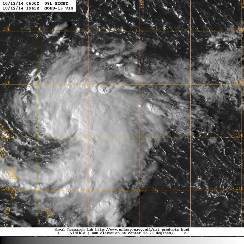
Here is another visible image with the wind directions in the islands. Impressive I have to say.
0 likes
Visit the Caribbean-Central America Weather Thread where you can find at first post web cams,radars
and observations from Caribbean basin members Click Here
and observations from Caribbean basin members Click Here


Looks very good on satellite to me. Certainly a case of "be ready for a category or two higher than forecast" here.
Personal Forecast Disclaimer:
The posts in this forum are NOT official forecast and should not be used as such. They are just the opinion of the poster and may or may not be backed by sound meteorological data. They are NOT endorsed by any professional institution or storm2k.org. For official information, please refer to the NHC and NWS products.
0 likes
Re: ATL: GONZALO - Tropical Storm - Discussion
I don't get it, if the forecast path shows a hurricane about to make landfall on PR/Western VI, why is it only a tropical storm watch there now?
Last edited by BobHarlem on Sun Oct 12, 2014 3:08 pm, edited 1 time in total.
0 likes


Re: ATL: GONZALO - Tropical Storm - Discussion
BobHarlem wrote:I don't get it, if the forecast path shows a hurricane about to make landfall on PR/Western VI, why is it only a tropical storm watch there now?
Never mind... 5PM
"A HURRICANE WATCH AND A TROPICAL STORM WARNING HAVE BEEN ISSUED FOR
PUERTO RICO...VIEQUES...CULEBRA...AND THE U.S. VIRGIN ISLANDS.
THE GOVERNMENT OF ANTIGUA AND BARBUDA HAS ISSUED A HURRICANE WATCH
AND A TROPICAL STORM WARNING FOR THE BRITISH VIRGIN ISLANDS."
0 likes
-
cycloneye
- Admin
- Posts: 149508
- Age: 69
- Joined: Thu Oct 10, 2002 10:54 am
- Location: San Juan, Puerto Rico
Re: ATL: GONZALO - Tropical Storm - Discussion

0 likes
Visit the Caribbean-Central America Weather Thread where you can find at first post web cams,radars
and observations from Caribbean basin members Click Here
and observations from Caribbean basin members Click Here
-
Gustywind

- Category 5

- Posts: 12334
- Joined: Mon Sep 03, 2007 7:29 am
- Location: Baie-Mahault, GUADELOUPE
Gonzalo's pressures down to 1004 mb now... while at 130 PM pressure was at 1009 mb.
BULLETIN
TROPICAL STORM GONZALO ADVISORY NUMBER 2
NWS NATIONAL HURRICANE CENTER MIAMI FL AL082014
500 PM AST SUN OCT 12 2014
...GONZALO STRENGTHENING EAST OF THE LEEWARD ISLANDS...
...HURRICANE WATCH AND TROPICAL STORM WARNING ISSUED...
SUMMARY OF 500 PM AST...2100 UTC...INFORMATION
----------------------------------------------
LOCATION...16.4N 59.5W
ABOUT 125 MI...205 KM E OF GUADELOUPE
ABOUT 160 MI...255 KM ESE OF ANTIGUA
MAXIMUM SUSTAINED WINDS...45 MPH...75 KM/H
PRESENT MOVEMENT...W OR 270 DEGREES AT 12 MPH...19 KM/H
MINIMUM CENTRAL PRESSURE...1004 MB...29.65 INCHES
0 likes


Re: ATL: GONZALO - Tropical Storm - Discussion
cycloneye wrote:
That's a pretty abrupt turn there.
0 likes
Re: ATL: GONZALO - Tropical Storm - Discussion
The 5pm discussion mentions a 10nm "primitive eye", which tells me that the advisory windspeed of 45MPH may be way on the low side. I hope this doesn't catch people blindsided in the islands. I wouldn't be shocked to wake up to a hurricane tomorrow if that continues.
0 likes
-
cycloneye
- Admin
- Posts: 149508
- Age: 69
- Joined: Thu Oct 10, 2002 10:54 am
- Location: San Juan, Puerto Rico
Re: ATL: GONZALO - Tropical Storm - Discussion
This sentence opened my eyes. 
Although occasional intrusions of dry mid-level air could briefly
disrupt the strengthening process, those occurrences should
generally be short-lived due to the strong instability conditions
that will be present. In fact, rapid intensification is a very
distinct possibility,
Although occasional intrusions of dry mid-level air could briefly
disrupt the strengthening process, those occurrences should
generally be short-lived due to the strong instability conditions
that will be present. In fact, rapid intensification is a very
distinct possibility,
0 likes
Visit the Caribbean-Central America Weather Thread where you can find at first post web cams,radars
and observations from Caribbean basin members Click Here
and observations from Caribbean basin members Click Here

-
TARHEELPROGRAMMER
If I was in PR or the USVI, I would ask myself "am I ready for a category 3 hurricane"?
Personal Forecast Disclaimer:
The posts in this forum are NOT official forecast and should not be used as such. They are just the opinion of the poster and may or may not be backed by sound meteorological data. They are NOT endorsed by any professional institution or storm2k.org. For official information, please refer to the NHC and NWS products.
0 likes
-
SeGaBob

Re: ATL: GONZALO - Tropical Storm - Discussion
Hmmm...colder than normal upper tropospheric temps, low forward speed, warm SSTs, strong vertical upward motion, and low shear. If there's a case for RI, this is it!
Last edited by ronjon on Sun Oct 12, 2014 5:01 pm, edited 1 time in total.
0 likes
Who is online
Users browsing this forum: No registered users and 40 guests