ATL: IDA - Remnants - Discussion

Moderator: S2k Moderators

Message
Author
User avatar
cheezyWXguy
Category 5
Category 5
Posts: 6108
Joined: Mon Feb 13, 2006 12:29 am
Location: Dallas, TX

Re: ATL: INVEST 99L - Discussion - Central Caribbean

#181 Postby cheezyWXguy » Wed Aug 25, 2021 3:14 pm

ConvergenceZone wrote:
Weather Dude wrote:
ConvergenceZone wrote:
Still, I think the lightning fast speed will be an inhibitor to significant strengthening. Just like we've seen with many past systems.....

Probably not if the conditions are favorable which it looks like they will be. Micheal landfalled as a Cat 5 three days after it formed. So I don't think forward speed will hurt it. Only things I can see that could keep somewhat of a lid on it are 95E (if it gets strong), or if 99L remains broad


Are you 100% sure that Michael was moving as fast as this is forecasted to move?


I don’t understand why you are so dead set on this. Drawing a line from Galveston (current TVCN projected landfall location) to the current location is about 1550 miles. Over the course of roughly 150 hours until landfall, that averages to hardly more than 10mph.
8 likes   

User avatar
Steve
S2K Supporter
S2K Supporter
Posts: 9620
Joined: Sat Apr 05, 2003 11:41 pm
Location: Not a state-caster

Re: ATL: INVEST 99L - Discussion - Central Caribbean

#182 Postby Steve » Wed Aug 25, 2021 3:16 pm

lrak wrote:Goofy question, do the forum sayings "weak means west" and "right biased models" only apply to certain environmental conditions? Like the massive high pressure we've had this summer?


Yes and not necessarily. Hey Karl.
4 likes   

User avatar
ConvergenceZone
Category 5
Category 5
Posts: 5194
Joined: Fri Jul 29, 2005 1:40 am
Location: Northern California

Re: ATL: INVEST 99L - Discussion - Central Caribbean

#183 Postby ConvergenceZone » Wed Aug 25, 2021 3:18 pm

cheezyWXguy wrote:
ConvergenceZone wrote:
Weather Dude wrote:Probably not if the conditions are favorable which it looks like they will be. Micheal landfalled as a Cat 5 three days after it formed. So I don't think forward speed will hurt it. Only things I can see that could keep somewhat of a lid on it are 95E (if it gets strong), or if 99L remains broad


Are you 100% sure that Michael was moving as fast as this is forecasted to move?


I don’t understand why you are so dead set on this. Drawing a line from Galveston (current TVCN projected landfall location) to the current location is about 1550 miles. Over the course of roughly 150 hours until landfall, that averages to hardly more than 10mph.


Fair Enough.... Regardless, I still think a Tuesday landfall is more likely...
0 likes   

User avatar
Kohlecane
Category 2
Category 2
Posts: 593
Age: 33
Joined: Sun Jul 31, 2011 11:03 pm
Location: Beaufort, SC

Re: ATL: INVEST 99L - Discussion - Central Caribbean

#184 Postby Kohlecane » Wed Aug 25, 2021 3:24 pm

ConvergenceZone wrote:
cheezyWXguy wrote:
ConvergenceZone wrote:
Are you 100% sure that Michael was moving as fast as this is forecasted to move?


I don’t understand why you are so dead set on this. Drawing a line from Galveston (current TVCN projected landfall location) to the current location is about 1550 miles. Over the course of roughly 150 hours until landfall, that averages to hardly more than 10mph.


Fair Enough.... Regardless, I still think a Tuesday landfall is more likely...

Image 
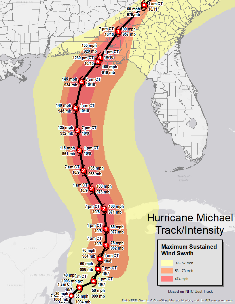
I don't have time for calculations lol waiting in line! but here you go :lol: sorry mods but it is useful to depict in the right environment and what seems to be be fast speed RI is achievable 8-)
5 likes   
Once I see the REDS and GREENS Converge on a Base Velocity. ... I'm There!!

This is NOT an Official Forecast....Just my Opinion. For official information, please refer to the NHC and NWS products.
HIGHLIGHTS : '13 El Reno Tornado : 2013 Storm Chaser Tour, Joaquin; SC flood event, Matthew '16, Lowcountry Snow storm Jan '18

floridasun78
Category 5
Category 5
Posts: 3755
Joined: Sun May 17, 2009 10:16 pm
Location: miami fl

Re: ATL: INVEST 99L - Discussion - Central Caribbean

#185 Postby floridasun78 » Wed Aug 25, 2021 3:46 pm

hope all in path are safe no one want see cat 4 hurr let hope not strong as models are saying we see alot stift models from now to landfall so be safe all in path dont go cazy with early models runs
4 likes   

grapealcoholic
Category 2
Category 2
Posts: 684
Joined: Tue Aug 10, 2021 3:26 pm

Re: ATL: INVEST 99L - Discussion - Central Caribbean

#186 Postby grapealcoholic » Wed Aug 25, 2021 3:52 pm

If advisories were being put out by the NHC right now, it would show a major hurricane landfalling in Houston.
5 likes   

User avatar
Kohlecane
Category 2
Category 2
Posts: 593
Age: 33
Joined: Sun Jul 31, 2011 11:03 pm
Location: Beaufort, SC

Re: ATL: INVEST 99L - Discussion - Central Caribbean

#187 Postby Kohlecane » Wed Aug 25, 2021 3:57 pm

grapealcoholic wrote:If advisories were being put out by the NHC right now, it would show a major hurricane landfalling in Houston.

Not to sure about that, they can always move up intensity as the day and advisories go on. Very rarely do they ever throw the M on there right off the bat, I could be wrong but not from what I can recall with a highly likely LF storm, seen it with OTS and MDR storms though of of first advisories with a cone!
0 likes   
Once I see the REDS and GREENS Converge on a Base Velocity. ... I'm There!!

This is NOT an Official Forecast....Just my Opinion. For official information, please refer to the NHC and NWS products.
HIGHLIGHTS : '13 El Reno Tornado : 2013 Storm Chaser Tour, Joaquin; SC flood event, Matthew '16, Lowcountry Snow storm Jan '18

grapealcoholic
Category 2
Category 2
Posts: 684
Joined: Tue Aug 10, 2021 3:26 pm

Re: ATL: INVEST 99L - Discussion - Central Caribbean

#188 Postby grapealcoholic » Wed Aug 25, 2021 4:03 pm

Kohlecane wrote:
grapealcoholic wrote:If advisories were being put out by the NHC right now, it would show a major hurricane landfalling in Houston.

Not to sure about that, they can always move up intensity as the day and advisories go on. Very rarely do they ever throw the M on there right off the bat, I could be wrong but not from what I can recall with a highly likely LF storm, seen it with OTS and MDR storms though of of first advisories with a cone!

Maybe not quite an M with the first advisory, but certainly a hurricane -- and Houston is currently the bullseye.
1 likes   


Senobia
Category 1
Category 1
Posts: 278
Joined: Sat Aug 05, 2006 2:59 pm
Location: Somewhere over the rainbow

Re: ATL: INVEST 99L - Discussion - Central Caribbean

#190 Postby Senobia » Wed Aug 25, 2021 4:08 pm

ConvergenceZone wrote:Someone correct me if I'm wrong or just explain how the heck the system suppose to be that strong when it's moving that fast? I'm seeing a system in the central Carib on Wednesday Afternoon and it may hit the gulf coast in only 5 days???? How the heck does it suppose to get that strong if the models have it moving that fast? Haven't we seen in the past that systems that move this fast usually take quite a bit of time to get strong, if they ever do at all?? Prior to me saying this, I had originally thought that the system would be entering the southern Gulf on Monday, as opposed to being way up in the North Gulf landfalling.... Thoughts on this??


Yep, I've been wondering the same thing.
0 likes   

grapealcoholic
Category 2
Category 2
Posts: 684
Joined: Tue Aug 10, 2021 3:26 pm

Re: ATL: INVEST 99L - Discussion - Central Caribbean

#191 Postby grapealcoholic » Wed Aug 25, 2021 4:11 pm

Senobia wrote:
ConvergenceZone wrote:Someone correct me if I'm wrong or just explain how the heck the system suppose to be that strong when it's moving that fast? I'm seeing a system in the central Carib on Wednesday Afternoon and it may hit the gulf coast in only 5 days???? How the heck does it suppose to get that strong if the models have it moving that fast? Haven't we seen in the past that systems that move this fast usually take quite a bit of time to get strong, if they ever do at all?? Prior to me saying this, I had originally thought that the system would be entering the southern Gulf on Monday, as opposed to being way up in the North Gulf landfalling.... Thoughts on this??


Yep, I've been wondering the same thing.

It doesn't seem to be moving that fast though?
0 likes   

User avatar
ElectricStorm
Category 5
Category 5
Posts: 5042
Age: 24
Joined: Tue Aug 13, 2019 11:23 pm
Location: Skiatook, OK / Norman, OK

Re: ATL: INVEST 99L - Discussion - Central Caribbean

#192 Postby ElectricStorm » Wed Aug 25, 2021 4:11 pm

TD14E in the EPAC is currently forecast to peak as a Cat 1 hurricane. As long as that one stays far enough away from Mexico, maybe it can overperform and move some shear over 99L. That and slow consolidation are about the only things that will be able to prevent RI in the gulf.

My guess is 14E/Nora won't hurt 99L much and this will be a big problem. Hopefully I'm wrong.
3 likes   
B.S Meteorology, University of Oklahoma '25

Please refer to the NHC, NWS, or SPC for official information.

User avatar
lrak
S2K Supporter
S2K Supporter
Posts: 1770
Age: 58
Joined: Thu Jun 21, 2007 2:48 pm
Location: Corpus Christi, TX

Re: ATL: INVEST 99L - Discussion - Central Caribbean

#193 Postby lrak » Wed Aug 25, 2021 4:12 pm

Steve wrote:
lrak wrote:Goofy question, do the forum sayings "weak means west" and "right biased models" only apply to certain environmental conditions? Like the massive high pressure we've had this summer?


Yes and not necessarily. Hey Karl.


Hi Steve...check your messages :spam:
1 likes   
AKA karl

Also
Personal Forecast Disclaimer:
My posts on this forum are NOT official forecast and should not be used as such. My posts are my basic observations and are definitely not backed by any "well some" meteorological knowledge. For official information, please refer to the NHC and NWS products.

CrazyC83
Professional-Met
Professional-Met
Posts: 34002
Joined: Tue Mar 07, 2006 11:57 pm
Location: Deep South, for the first time!

Re: ATL: INVEST 99L - Discussion - Central Caribbean

#194 Postby CrazyC83 » Wed Aug 25, 2021 4:21 pm

grapealcoholic wrote:
Kohlecane wrote:
grapealcoholic wrote:If advisories were being put out by the NHC right now, it would show a major hurricane landfalling in Houston.

Not to sure about that, they can always move up intensity as the day and advisories go on. Very rarely do they ever throw the M on there right off the bat, I could be wrong but not from what I can recall with a highly likely LF storm, seen it with OTS and MDR storms though of of first advisories with a cone!

Maybe not quite an M with the first advisory, but certainly a hurricane -- and Houston is currently the bullseye.


What is the strongest the NHC has ever forecast within 5 days on advisory #1?
1 likes   

xironman
S2K Supporter
S2K Supporter
Posts: 2522
Joined: Sun Jun 10, 2007 4:53 pm
Location: NoVA

Re: ATL: INVEST 99L - Discussion - Central Caribbean

#195 Postby xironman » Wed Aug 25, 2021 4:32 pm

So anybody playing at home. I would go north and east because that seems like it is where it wants to set up.

Image
1 likes   

User avatar
galaxy401
Category 5
Category 5
Posts: 2419
Age: 30
Joined: Sat Aug 25, 2012 9:04 pm
Location: Casa Grande, Arizona

Re: ATL: INVEST 99L - Discussion - Central Caribbean

#196 Postby galaxy401 » Wed Aug 25, 2021 4:35 pm

If the more northern part ends up developing, there's a serious chance it could miss the Yucatan entirely. Some of the models, such as the ICON, have it missing the peninsula. That could make for a stronger system...
0 likes   
Got my eyes on moving right into Hurricane Alley: Florida.

User avatar
MGC
S2K Supporter
S2K Supporter
Posts: 5896
Joined: Sun Mar 23, 2003 9:05 pm
Location: Pass Christian MS, or what is left.

Re: ATL: INVEST 99L - Discussion - Central Caribbean

#197 Postby MGC » Wed Aug 25, 2021 4:36 pm

Starting to get that tumbleweed look. Could be a long week ahead for folks on the gulf coast of Texas and Louisiana......MGC
1 likes   

User avatar
kevin
Category 5
Category 5
Posts: 2586
Age: 26
Joined: Wed Aug 28, 2019 4:35 am

Re: ATL: INVEST 99L - Discussion - Central Caribbean

#198 Postby kevin » Wed Aug 25, 2021 4:37 pm

CrazyC83 wrote:
grapealcoholic wrote:
Kohlecane wrote:Not to sure about that, they can always move up intensity as the day and advisories go on. Very rarely do they ever throw the M on there right off the bat, I could be wrong but not from what I can recall with a highly likely LF storm, seen it with OTS and MDR storms though of of first advisories with a cone!

Maybe not quite an M with the first advisory, but certainly a hurricane -- and Houston is currently the bullseye.


What is the strongest the NHC has ever forecast within 5 days on advisory #1?


I think Teddy was the strongest advisory #1, I remember people talking about it when the 1st advisory was released.

Edit: I guess I was mistaken, just checked it and the first advisory only had 80 kts. I do still clearly remember a relatively recent storm getting 95 kts in its 1st advisory, but I'm not sure which one.
Last edited by kevin on Wed Aug 25, 2021 4:41 pm, edited 1 time in total.
0 likes   

emings
Tropical Low
Tropical Low
Posts: 34
Joined: Mon Jun 18, 2018 3:16 pm

Re: ATL: INVEST 99L - Discussion - Central Caribbean

#199 Postby emings » Wed Aug 25, 2021 4:37 pm

CrazyC83 wrote:
grapealcoholic wrote:
Kohlecane wrote:Not to sure about that, they can always move up intensity as the day and advisories go on. Very rarely do they ever throw the M on there right off the bat, I could be wrong but not from what I can recall with a highly likely LF storm, seen it with OTS and MDR storms though of of first advisories with a cone!

Maybe not quite an M with the first advisory, but certainly a hurricane -- and Houston is currently the bullseye.


What is the strongest the NHC has ever forecast within 5 days on advisory #1?


Hurricane Delta last year went from a Tropical Depression to a Category 4 Storm in less than 36 hours. Fastest one I remember was Humberto back in 2007 went from a tropical depression to a Hurricane in 12 Hours.
0 likes   
Personal Forecast Disclaimer:
The posts in this forum are NOT official forecast and should not be used as such. They are just the opinion of the poster and may or may not be backed by sound meteorological data. They are NOT endorsed by any professional institution or storm2k.org. For official information, please refer to the NHC and NWS products.

User avatar
abajan
S2K Supporter
S2K Supporter
Posts: 4230
Joined: Sun Sep 07, 2003 5:10 am
Location: Barbados

Re: ATL: INVEST 99L - Discussion - Central Caribbean

#200 Postby abajan » Wed Aug 25, 2021 4:38 pm

[youtube]https://youtu.be/UzhXcGc2tuM[/youtube]
1 likes   


Return to “2021”

Who is online

Users browsing this forum: No registered users and 0 guests