ATL: HELENE - Post-Tropical - Discussion

Moderator: S2k Moderators

Message
Author
User avatar
cycloneye
Admin
Admin
Posts: 145296
Age: 68
Joined: Thu Oct 10, 2002 10:54 am
Location: San Juan, Puerto Rico

Re: ATL: INVEST 97L - Discussion

#181 Postby cycloneye » Mon Sep 23, 2024 6:35 am

8 AM: PTC at 11 AM EDT.

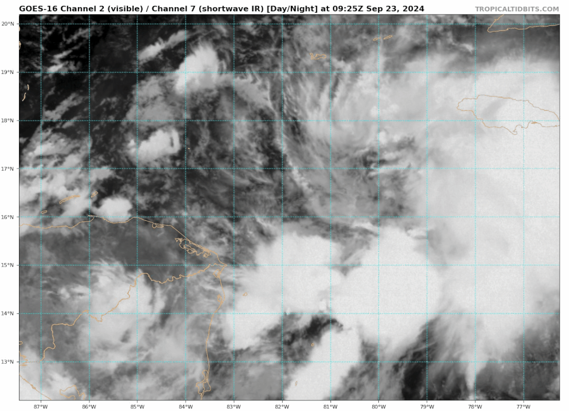
Northwestern Caribbean Sea and Gulf of Mexico (AL97):
Showers and thunderstorms are gradually becoming better organized in
association with a broad area of low pressure located over the
northwestern Caribbean Sea. Environmental conditions appear
favorable for further development of this system. A tropical
depression or storm is likely to form within the next day or two as
the system moves northward across the northwestern Caribbean Sea and
into the southeastern Gulf of Mexico, where additional development
is expected.

1. Regardless of development, this system is expected to produce heavy
rains over portions of Central America during the next several days.
Interests in the northwestern Caribbean, the Yucatan Peninsula of
Mexico, and western Cuba should closely monitor the progress of this
system, as watches or warnings will likely be required later
this morning for portions of these areas. Later this week, the
system is forecast to move generally northward across the eastern
Gulf of Mexico, and interests along the northern and northeastern
Gulf Coast should also closely monitor the progress of this system.
* Formation chance through 48 hours...high...80 percent.
* Formation chance through 7 days...high...90 percent.
0 likes   
Visit the Caribbean-Central America Weather Thread where you can find at first post web cams,radars
and observations from Caribbean basin members Click Here

Stormlover70
Tropical Storm
Tropical Storm
Posts: 175
Age: 55
Joined: Fri Jun 21, 2024 5:31 am
Location: New port richey

Re: ATL: INVEST 97L - Discussion

#182 Postby Stormlover70 » Mon Sep 23, 2024 6:36 am

wxman57 wrote:For now, I have landfall northern Apalachee Bay Thursday afternoon. Moving north at 20 kts at landfall. Lots of SW shear across northern Gulf. Initial forecast has 75 kts at landfall. Large wind field, particularly east of the center. Could produce tides 5-10 ft into Tampa - higher if the track shifts any east.
finally the voice of reason. Welcome back. I hope you enjoyed your time off
Albeit a few days.
0 likes   

User avatar
ouragans
Category 1
Category 1
Posts: 490
Age: 53
Joined: Sun Jun 12, 2011 12:09 pm
Location: Abymes, Guadeloupe F.W.I
Contact:

Re: ATL: INVEST 97L - Discussion

#183 Postby ouragans » Mon Sep 23, 2024 6:37 am

Interests in the northwestern Caribbean, the Yucatan Peninsula of Mexico, and western Cuba should closely monitor the progress of this system, as watches or warnings will likely be required later this morning for portions of these areas.


We should have a PTC at 15z
Last edited by ouragans on Mon Sep 23, 2024 6:39 am, edited 1 time in total.
1 likes   
Personal forecast disclaimer
This post is a personal point of view, not an information. Please refer to official statements for life-threatening decisions.

David '79, Frederic '79, Hugo '89, Iris, Luis & Marilyn '95, Georges '98, Lenny '99, Dean '07, Irma '17, Maria '17, Fiona '22, Philippe '23, Tammy '23
16°13'33.3,"6N -61°36'39.5"W

User avatar
Hypercane_Kyle
Category 5
Category 5
Posts: 3352
Joined: Sat Mar 07, 2015 7:58 pm
Location: Cape Canaveral, FL

Re: ATL: INVEST 97L - Discussion

#184 Postby Hypercane_Kyle » Mon Sep 23, 2024 6:37 am

Either outflow from TS John or displacement of the ULAC appears to be causing 97L to form more east than expected. This is why the GFS/Euro has shifted east. Tampa needs to be on alert for these trends to continue.
4 likes   
My posts are my own personal opinion, defer to the National Hurricane Center (NHC) and other NOAA products for decision making during hurricane season.

User avatar
GCANE
S2K Supporter
S2K Supporter
Posts: 11496
Joined: Mon Oct 22, 2007 8:03 am

Re: ATL: INVEST 97L - Discussion

#185 Postby GCANE » Mon Sep 23, 2024 6:38 am

Looking at the latest GFS, once this passes the Yucatan Channel it will be under a minor ARWB created by the trof.
Looks like it will be able to strengthen during a good portion of its trek in the GoM due to the ARWB and a very strong high TPW feed from the EPAC.
Shear will pickup as it closes into the trof and landfall.
Last edited by GCANE on Mon Sep 23, 2024 6:49 am, edited 1 time in total.
3 likes   

User avatar
aspen
Category 5
Category 5
Posts: 8818
Joined: Sat Oct 12, 2019 7:10 pm
Location: Connecticut, USA

Re: ATL: INVEST 97L - Discussion

#186 Postby aspen » Mon Sep 23, 2024 6:39 am

Hypercane_Kyle wrote:Either outflow from TS John or displacement of the ULAC appears to be causing 97L to form more east than expected. This is why the GFS/Euro has shifted east. Tampa needs to be on alert for these trends to continue.

I’m willing to bet it’s from John, because the HWRF-P 200mb flow does show a little bit of John’s outflow intersecting 97L/Helene at some point during the next 2 days.
0 likes   
Irene '11 Sandy '12 Hermine '16 5/15/2018 Derecho Fay '20 Isaias '20 Elsa '21 Henri '21 Ida '21

I am only a meteorology enthusiast who knows a decent amount about tropical cyclones. Look to the professional mets, the NHC, or your local weather office for the best information.

xironman
S2K Supporter
S2K Supporter
Posts: 2522
Joined: Sun Jun 10, 2007 4:53 pm
Location: NoVA

Re: ATL: INVEST 97L - Discussion

#187 Postby xironman » Mon Sep 23, 2024 6:51 am

aspen wrote:
Hypercane_Kyle wrote:Either outflow from TS John or displacement of the ULAC appears to be causing 97L to form more east than expected. This is why the GFS/Euro has shifted east. Tampa needs to be on alert for these trends to continue.

I’m willing to bet it’s from John, because the HWRF-P 200mb flow does show a little bit of John’s outflow intersecting 97L/Helene at some point during the next 2 days.


The upper trough over the Yucatan channel is probably contributing to.

Image
1 likes   

User avatar
wxman57
Moderator-Pro Met
Moderator-Pro Met
Posts: 22978
Age: 67
Joined: Sat Jun 21, 2003 8:06 pm
Location: Houston, TX (southwest)

Re: ATL: INVEST 97L - Discussion

#188 Postby wxman57 » Mon Sep 23, 2024 6:53 am

Stormlover70 wrote:
wxman57 wrote:For now, I have landfall northern Apalachee Bay Thursday afternoon. Moving north at 20 kts at landfall. Lots of SW shear across northern Gulf. Initial forecast has 75 kts at landfall. Large wind field, particularly east of the center. Could produce tides 5-10 ft into Tampa - higher if the track shifts any east.
finally the voice of reason. Welcome back. I hope you enjoyed your time off
Albeit a few days.


Yes, I enjoyed the last 4 days off.

Note that large upper-level low positioned over Arkansas this week. That's why all the models are in very good agreement on an east FL Panhandle hit. Very strong SW wind aloft across central to northern Gulf should cause most strong wind and squalls to be positioned east of the track. Watch out west coast of FL Peninsula.
5 likes   

User avatar
chris_fit
Category 5
Category 5
Posts: 3222
Age: 42
Joined: Wed Sep 10, 2003 11:58 pm
Location: Tampa Bay Area, FL

Re: ATL: INVEST 97L - Discussion= 8 AM TWO= PTC at 11 AM EDT

#189 Postby chris_fit » Mon Sep 23, 2024 6:53 am

@WXMAN57 - Thoughts on Tampa Area for severe impacts? Should we be worried here? I know you've said many times "they always go right of track" - Is the setup the same where this would apply? (Charley, Ian, Irma) or is this more of an Idalia event where I believe it went a little West of track?
1 likes   

underthwx
Category 5
Category 5
Posts: 2360
Joined: Sat Jul 30, 2011 2:14 pm
Location: Brazoria County Texas

Re: ATL: INVEST 97L - Discussion

#190 Postby underthwx » Mon Sep 23, 2024 7:03 am

wxman57 wrote:
Stormlover70 wrote:
wxman57 wrote:For now, I have landfall northern Apalachee Bay Thursday afternoon. Moving north at 20 kts at landfall. Lots of SW shear across northern Gulf. Initial forecast has 75 kts at landfall. Large wind field, particularly east of the center. Could produce tides 5-10 ft into Tampa - higher if the track shifts any east.
finally the voice of reason. Welcome back. I hope you enjoyed your time off
Albeit a few days.


Yes, I enjoyed the last 4 days off.

Note that large upper-level low positioned over Arkansas this week. That's why all the models are in very good agreement on an east FL Panhandle hit. Very strong SW wind aloft across central to northern Gulf should cause most strong wind and squalls to be positioned east of the track. Watch out west coast of FL Peninsula.

Good morning Xman....the low you mention over Arkanasas....is 97L actually going to keep that low positioned where it is?....if I understand this correctly...the low over Arkansas is the main force that is pulling 97L Northward?.....i read this excerpt from Houston/Galveston forecast discussion..."The upper level pattern gets a bit messy by the end of the week.
That closed low that stalls over the Mississippi Valley ends up
retrograding back westward Friday and into the weekend. This is due
to a tropical system (currently Invest 97L in the western Caribbean,
but likely a named tropical system by midweek) moving through the
eastern Gulf of Mexico effectively blocking the movement of the
upper level low. So, as this system moves back westward, so does the
moisture associated with it. The wrap around moisture may bring
scattered showers and storms to our area Friday into the weekend -
but confidence is not exactly high as it will be determined where
exactly the upper level low retrogrades to and how it interacts with
the tropical system. That upper level low ends up sticking around
through much of the weekend before finally moving off east late
Sunday into Monday".....is this the low you mention?.....many thanks...
Last edited by underthwx on Mon Sep 23, 2024 7:07 am, edited 1 time in total.
0 likes   

User avatar
Blown Away
S2K Supporter
S2K Supporter
Posts: 10145
Joined: Wed May 26, 2004 6:17 am

Re: ATL: INVEST 97L - Discussion= 8 AM TWO= PTC at 11 AM EDT

#191 Postby Blown Away » Mon Sep 23, 2024 7:05 am

Image

Some bubbling occurring near the rotation @17N/80.5W…
1 likes   
Hurricane Eye Experience: David 79, Irene 99, Frances 04, Jeanne 04, Wilma 05... EYE COMING MY WAY IN 2024…
Hurricane Brush Experience: Andrew 92, Erin 95, Floyd 99, Matthew 16, Irma 17, Ian 22, Nicole 22…

User avatar
StPeteMike
Category 2
Category 2
Posts: 631
Joined: Thu Jun 07, 2018 11:26 pm

Re: ATL: INVEST 97L - Discussion= 8 AM TWO= PTC at 11 AM EDT

#192 Postby StPeteMike » Mon Sep 23, 2024 7:09 am

Blown Away wrote:[url]https://i.postimg.cc/V66SGtYW/goes16-vis-swir-97-L-202409230925.gif [/url]

Some bubbling occurring near the rotation @17N/80.5W…

Yep! She’ll likely fill herself in with convection the rest of the morning and afternoon. We shall see what she looks like around 1700 eastern.
1 likes   
The above post is not official and should not be used as such. It is the opinion of the poster and may or may not be backed by sound meteorological data. It is not endorsed by any professional institution or storm2k.org. For official information, please refer to the NHC and NWS products.

DunedinDave
Tropical Storm
Tropical Storm
Posts: 227
Joined: Fri Aug 25, 2023 10:31 am

Re: ATL: INVEST 97L - Discussion= 8 AM TWO= PTC at 11 AM EDT

#193 Postby DunedinDave » Mon Sep 23, 2024 7:11 am

Blown Away wrote:[url]https://i.postimg.cc/V66SGtYW/goes16-vis-swir-97-L-202409230925.gif [/url]

Some bubbling occurring near the rotation @17N/80.5W…

Definitely a spin there. Wow that’s way east. Kudos to GFS…they caught on to that and factored it into their latest model run (hence the east shift).
1 likes   

User avatar
wxman57
Moderator-Pro Met
Moderator-Pro Met
Posts: 22978
Age: 67
Joined: Sat Jun 21, 2003 8:06 pm
Location: Houston, TX (southwest)

Re: ATL: INVEST 97L - Discussion= 8 AM TWO= PTC at 11 AM EDT

#194 Postby wxman57 » Mon Sep 23, 2024 7:21 am

The ICON has done very well with Gulf storms this year. The main steering factor will be a large and strong upper-level low over Arkansas. This will keep "Helene" out of the NW Gulf. As for questions about Tampa - yes, there is a better chance of the storm tracking closer to Tampa. As it stands now, we're looking at a 5-8 ft surge into Tampa, even with the storm passing well to the west. The 20kt northerly forward speed across the NE Gulf is a testament to the well-established steering flow.

https://www.tropicaltidbits.com/analysis/models/icon/2024092306/icon_z500_vort_watl_30.png
8 likes   

psyclone
S2K Supporter
S2K Supporter
Posts: 4762
Joined: Wed Aug 24, 2005 9:04 pm
Location: palm harbor fl

Re: ATL: INVEST 97L - Discussion= 8 AM TWO= PTC at 11 AM EDT

#195 Postby psyclone » Mon Sep 23, 2024 7:27 am

That's a very vigorous spin. This thing is going to take off soon and fast. PTC designation won't be needed long on this one. This current look reminds me of Ian before it went nuts. Let's hope this one under shoots that one by a lot. Very surge prone coast around Tampa bay. I'm right at the top of the bay...thankfully on high ground but close to very vulnerable areas.
5 likes   

User avatar
cycloneye
Admin
Admin
Posts: 145296
Age: 68
Joined: Thu Oct 10, 2002 10:54 am
Location: San Juan, Puerto Rico

Re: ATL: INVEST 97L - Discussion= 8 AM TWO= PTC at 11 AM EDT

#196 Postby cycloneye » Mon Sep 23, 2024 7:28 am

2 likes   
Visit the Caribbean-Central America Weather Thread where you can find at first post web cams,radars
and observations from Caribbean basin members Click Here

User avatar
boca
Category 5
Category 5
Posts: 6367
Age: 60
Joined: Mon Dec 15, 2003 8:49 am
Location: Boca Raton,FL

Re: ATL: INVEST 97L - Discussion= 8 AM TWO= PTC at 11 AM EDT

#197 Postby boca » Mon Sep 23, 2024 7:29 am

Blown Away wrote:[url]https://i.postimg.cc/V66SGtYW/goes16-vis-swir-97-L-202409230925.gif [/url]

Some bubbling occurring near the rotation @17N/80.5W…


If that becomes the center the SE coast of Florida might be getting alittle more action than just rain showers .
2 likes   

underthwx
Category 5
Category 5
Posts: 2360
Joined: Sat Jul 30, 2011 2:14 pm
Location: Brazoria County Texas

Re: ATL: INVEST 97L - Discussion= 8 AM TWO= PTC at 11 AM EDT

#198 Postby underthwx » Mon Sep 23, 2024 7:32 am

psyclone wrote:That's a very vigorous spin. This thing is going to take off soon and fast. PTC designation won't be needed long on this one. This current look reminds me of Ian before it went nuts. Let's hope this one under shoots that one by a lot. Very surge prone coast around Tampa bay. I'm right at the top of the bay...thankfully on high ground but close to very vulnerable areas.

I wish you...and all yall in potential impact areas...the best....this is shaping up to be an event that will affect millions along the coast of Florida and points northward.....lets get this system outta here quickly....
1 likes   

User avatar
WaveBreaking
Category 2
Category 2
Posts: 578
Joined: Sun Jun 30, 2024 11:33 am
Location: US

Re: ATL: INVEST 97L - Discussion= 8 AM TWO= PTC at 11 AM EDT

#199 Postby WaveBreaking » Mon Sep 23, 2024 7:32 am

Convection firing closer to the vortmax.

Image
2 likes   
I am NOT a professional meteorologist, so take all of my posts with a grain of salt. My opinions are mine and mine alone.

User avatar
cycloneye
Admin
Admin
Posts: 145296
Age: 68
Joined: Thu Oct 10, 2002 10:54 am
Location: San Juan, Puerto Rico

Re: ATL: INVEST 97L - Discussion= 8 AM TWO= PTC at 11 AM EDT

#200 Postby cycloneye » Mon Sep 23, 2024 7:41 am

12z Best Track:

AL, 97, 2024092312, , BEST, 0, 172N, 818W, 25, 1004, DB
1 likes   
Visit the Caribbean-Central America Weather Thread where you can find at first post web cams,radars
and observations from Caribbean basin members Click Here


Return to “2024”

Who is online

Users browsing this forum: No registered users and 7 guests