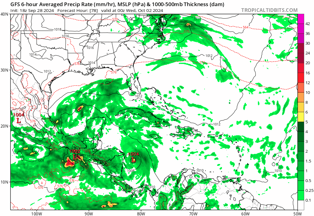
Possible development in the Gulf of Mexico (Is Invest 92L)

This is the general tropical discussion area. Anyone can take their shot at predicting a storms path.

Moderator: S2k Moderators

Forum rules

The posts in this forum are NOT official forecasts and should not be used as such. They are just the opinion of the poster and may or may not be backed by sound meteorological data. They are NOT endorsed by any professional institution or STORM2K. For official information, please refer to products from the National Hurricane Center and National Weather Service.

Help Support Storm2K
Message
Author
jlauderdal
S2K Supporter
S2K Supporter
Posts: 7182
Joined: Wed May 19, 2004 5:46 am
Location: NE Fort Lauderdale
Contact:

Re: Possible development in the Western Caribbean (0/50)

#181 Postby jlauderdal » Sun Sep 29, 2024 5:42 am

mantis83 wrote:6Z gfs has this a weak stretched out mess like the euro now......

Yes, similar idea albeit more organized than the euro but certainly nothing impressive. We saw windshiled wiper effects with Helene, this may be the same. Will follow ensembles more for now.
1 likes   

User avatar
cycloneye
Admin
Admin
Posts: 145296
Age: 68
Joined: Thu Oct 10, 2002 10:54 am
Location: San Juan, Puerto Rico

Re: Possible development in the Western Caribbean (0/50)

#182 Postby cycloneye » Sun Sep 29, 2024 6:56 am

8 AM:

Western Caribbean Sea and Gulf of Mexico:
A broad area of low pressure located over the western Caribbean Sea
is producing disorganized showers and thunderstorms. Environmental
conditions appear to be conducive for gradual development, and a
tropical depression could form around the middle part of this week
while the disturbance meanders towards the west-northwest. This
system is then expected to move northwestward into the Gulf of
Mexico during the latter portion of this week, and interests in the
northwestern Caribbean Sea and along the U.S. Gulf Coast should
monitor its progress.
* Formation chance through 48 hours...low...near 0 percent.
* Formation chance through 7 days...medium...50 percent.
0 likes   
Visit the Caribbean-Central America Weather Thread where you can find at first post web cams,radars
and observations from Caribbean basin members Click Here

User avatar
SFLcane
S2K Supporter
S2K Supporter
Posts: 10163
Age: 47
Joined: Sat Jun 05, 2010 1:44 pm
Location: Lake Worth Florida

Re: Possible development in the Western Caribbean (0/50)

#183 Postby SFLcane » Sun Sep 29, 2024 7:25 am

1 likes   

User avatar
wxman57
Moderator-Pro Met
Moderator-Pro Met
Posts: 22978
Age: 67
Joined: Sat Jun 21, 2003 8:06 pm
Location: Houston, TX (southwest)

Re: Possible development in the Western Caribbean (0/50)

#184 Postby wxman57 » Sun Sep 29, 2024 7:43 am

Even the 6Z GFS is coming around to the ICON's solution of a weak low along a cold front. Let's hope that's the case.
7 likes   

underthwx
Category 5
Category 5
Posts: 2360
Joined: Sat Jul 30, 2011 2:14 pm
Location: Brazoria County Texas

Re: Possible development in the Western Caribbean (0/50)

#185 Postby underthwx » Sun Sep 29, 2024 8:03 am

wxman57 wrote:Even the 6Z GFS is coming around to the ICON's solution of a weak low along a cold front. Let's hope that's the case.

I second that.....nobody needs another storm.....btw...yall check out this mornings Hou/Galveston forecast discussion....its a tribute to national coffee day!....coffee is on me!....
2 likes   

User avatar
SFLcane
S2K Supporter
S2K Supporter
Posts: 10163
Age: 47
Joined: Sat Jun 05, 2010 1:44 pm
Location: Lake Worth Florida

Re: Possible development in the Western Caribbean (0/50)

#186 Postby SFLcane » Sun Sep 29, 2024 9:23 am

Trend overnight is for some rain for Florida which is certainly a great thing. Still many in northern FL without power.
0 likes   

Senobia
Category 1
Category 1
Posts: 278
Joined: Sat Aug 05, 2006 2:59 pm
Location: Somewhere over the rainbow

Re: Possible development in the Western Caribbean (0/50)

#187 Postby Senobia » Sun Sep 29, 2024 9:28 am

gatorcane wrote:The entire 18Z GFS track shifted to the right quite a bit this run, and while it landfalls in the panhandle (at almost 200 hours which is still far out, plenty of shifting to still happen), that hook to the right is definitely something to keep an eye on because this could end up easily being a storm that hits the west coast of Florida from the Central Gulf on an ENE track.

https://i.postimg.cc/G27ftMsv/gfs-mslp-pcpn-watl-fh78-216.gif


What's that spin up into the Texas coast October 3-5?
0 likes   

User avatar
Kingarabian
S2K Supporter
S2K Supporter
Posts: 15980
Joined: Sat Aug 08, 2009 3:06 am
Location: Honolulu, Hawaii

Re: Possible development in the Western Caribbean (0/50)

#188 Postby Kingarabian » Sun Sep 29, 2024 9:55 am

It looks like the model runs with a stronger GOM system, the modeled EPAC system off of Mexico is much weaker. And vice versa. So I would pay attention to what happens in the EPAC in regards to the future of this system.
2 likes   
RIP Kobe Bryant

User avatar
ConvergenceZone
Category 5
Category 5
Posts: 5194
Joined: Fri Jul 29, 2005 1:40 am
Location: Northern California

Re: Possible development in the Western Caribbean (0/50)

#189 Postby ConvergenceZone » Sun Sep 29, 2024 10:23 am

wxman57 wrote:Even the 6Z GFS is coming around to the ICON's solution of a weak low along a cold front. Let's hope that's the case.


That's great news. It definitely doesn't look at all like the beefy setup we had with Helene. Hopefully the Low will move out quickly and not cause too much rain.
0 likes   

Michele B
S2K Supporter
S2K Supporter
Posts: 1114
Joined: Thu Aug 25, 2016 8:08 am
Location: SWFL

Re: Possible development in the Western Caribbean (0/50)

#190 Postby Michele B » Sun Sep 29, 2024 10:41 am

tiger_deF wrote:Worth pointing out that the GFS has trackeable vorticity and cyclogenesis in 2-3 days. Considering that we were tracking the potential of Helene for over a week and a half, this one feels like it just snuck up on us.


Maybe it just seems that way because we were so focused on what Helene was doing and where she was going.
1 likes   
Cleo - 1964, Betsy - 1965, David - 1979, Andrew - 1992, Charlie (Francis, Ivan, Jeanne) - 2004, Irma - 2017, Ian - 2022

underthwx
Category 5
Category 5
Posts: 2360
Joined: Sat Jul 30, 2011 2:14 pm
Location: Brazoria County Texas

Re: Possible development in the Western Caribbean (0/50)

#191 Postby underthwx » Sun Sep 29, 2024 11:12 am

This is an excerpt from NWS Atlanta morning forecast discussion referring to possible tropical development later next week in the Gulf of Mexico.......

"By next weekend there is a potential for tropical development yet
again in Gulf of Mexico or Caribbean Sea. The GFS has been wanting to develop a low pressure system in this region for a couple of model runs now. More concerning though is that a considerable chunk of EPS and GEFS members (> 50%) are also showing low pressure development. Any tropical activity that develops would likely move into the Gulf, where upper level ridging over the western Atlantic may eventually funnel it towards the north. The National Hurricane Center is giving this region a 50% chance of tropical development over the next 7 days."....

I think this will translate into what Xman57 has noted in earlier posts.....its looking as though at a minimum...deeper tropical moisture may possibly plague that region with unwanted rainfall...as our friends in the southeast... work to recover from the damage brought by Hurricane Helene....I hope that blue skies will prevail!...
0 likes   

User avatar
Jr0d
S2K Supporter
S2K Supporter
Posts: 1409
Joined: Tue Aug 27, 2019 10:52 am
Location: Cayo Hueso

Re: Possible development in the Western Caribbean (0/50)

#192 Postby Jr0d » Sun Sep 29, 2024 11:19 am

Michele B wrote:
tiger_deF wrote:Worth pointing out that the GFS has trackeable vorticity and cyclogenesis in 2-3 days. Considering that we were tracking the potential of Helene for over a week and a half, this one feels like it just snuck up on us.


Maybe it just seems that way because we were so focused on what Helene was doing and where she was going.


I noticed it starting to show up almost a week ago. Wednesday at work a few excited people were trying to tell me we have another hurricane coming next week...of course I tried to explain to them that far out computer models are just a guess and there is no system yet so its a bit premature to get excited about a computer simulated storm.

As we get closer to the potential genesis point of this one, the trend is a good one. Hopefully it will just be a frontal low that quickly exits to northeast and hopefully have little if any impact on the clean up and rebuilding efforts in the southeast states.

I do think the West Caribbean, southeast Gulf of Mexico still could give us another significant storm. I dont think 90L will be it.
4 likes   

Frank P
S2K Supporter
S2K Supporter
Posts: 2776
Joined: Fri Aug 29, 2003 10:52 am
Location: Biloxi Beach, Ms
Contact:

Re: Possible development in the Western Caribbean (0/50)

#193 Postby Frank P » Sun Sep 29, 2024 12:15 pm

GFS 12z model run says what cold front? More GFS shenanigans me thinks!
Image
0 likes   

canes92
Tropical Storm
Tropical Storm
Posts: 127
Age: 32
Joined: Tue Mar 06, 2018 1:51 pm

Re: Possible development in the Western Caribbean (0/50)

#194 Postby canes92 » Sun Sep 29, 2024 12:16 pm

Jr0d wrote:
Michele B wrote:
tiger_deF wrote:Worth pointing out that the GFS has trackeable vorticity and cyclogenesis in 2-3 days. Considering that we were tracking the potential of Helene for over a week and a half, this one feels like it just snuck up on us.


Maybe it just seems that way because we were so focused on what Helene was doing and where she was going.


I noticed it starting to show up almost a week ago. Wednesday at work a few excited people were trying to tell me we have another hurricane coming next week...of course I tried to explain to them that far out computer models are just a guess and there is no system yet so its a bit premature to get excited about a computer simulated storm.

As we get closer to the potential genesis point of this one, the trend is a good one. Hopefully it will just be a frontal low that quickly exits to northeast and hopefully have little if any impact on the clean up and rebuilding efforts in the southeast states.

I do think the West Caribbean, southeast Gulf of Mexico still could give us another significant storm. I dont think 90L will be it.


What? These folks want damage, flooding, and increased home owners insurance rates??
0 likes   

otowntiger
Category 5
Category 5
Posts: 1921
Joined: Tue Aug 31, 2004 7:06 pm

Re: Possible development in the Western Caribbean (0/50)

#195 Postby otowntiger » Sun Sep 29, 2024 12:32 pm


The good thing is all, or the vast majority appear to be pretty weak- i.e. weak TS’s or TD’s. Just a couple seem to make it to cat 1 status, if I’m not mistaken.
0 likes   

hurricanehunter69
Category 1
Category 1
Posts: 343
Joined: Sun May 16, 2010 5:21 pm
Location: New Orleans

Re: Possible development in the Western Caribbean (0/50)

#196 Postby hurricanehunter69 » Sun Sep 29, 2024 12:34 pm

I don't see a cold front passing through the N gulf coast anytime soon either, whilst looking at Mimic TPW. The NHC has been insistent on a NW to North track with this thing. Not buying a hard right turn to Florida. If I lived in Mississippi and or Alabama I'd be paying close attention. Can't tell you how many arguments at work about it NOT going to Texas. As for intensity....we don't have a summer environment here on the N gulf coast but we don't have a Fall environment either...
0 likes   

User avatar
cycloneye
Admin
Admin
Posts: 145296
Age: 68
Joined: Thu Oct 10, 2002 10:54 am
Location: San Juan, Puerto Rico

Re: Possible development in the Western Caribbean (0/50)

#197 Postby cycloneye » Sun Sep 29, 2024 12:58 pm

2 PM:

Western Caribbean Sea and Gulf of Mexico:
A broad area of low pressure located over the western Caribbean Sea
is producing disorganized showers and thunderstorms. Environmental
conditions appear to be conducive for gradual development, and a
tropical depression could form around the middle part of this week
while the disturbance meanders towards the west-northwest. This
system is then expected to move northwestward into the Gulf of
Mexico during the latter portion of this week, and interests in the
northwestern Caribbean Sea and along the U.S. Gulf Coast should
monitor its progress.
* Formation chance through 48 hours...low...near 0 percent.
* Formation chance through 7 days...medium...50 percent.
0 likes   
Visit the Caribbean-Central America Weather Thread where you can find at first post web cams,radars
and observations from Caribbean basin members Click Here

Frank P
S2K Supporter
S2K Supporter
Posts: 2776
Joined: Fri Aug 29, 2003 10:52 am
Location: Biloxi Beach, Ms
Contact:

Re: Possible development in the Western Caribbean (0/50)

#198 Postby Frank P » Sun Sep 29, 2024 1:18 pm

Moisture building in the extreme SW Caribbean.
Image
2 likes   

User avatar
toad strangler
S2K Supporter
S2K Supporter
Posts: 4543
Joined: Sun Jul 28, 2013 3:09 pm
Location: Earth
Contact:

Re: Possible development in the Western Caribbean (0/50)

#199 Postby toad strangler » Sun Sep 29, 2024 1:52 pm

SFLcane wrote:Trend overnight is for some rain for Florida which is certainly a great thing. Still many in northern FL without power.


Rain without wind and surge would be a tremendous thing. Especially since wet season end looms in a couple to few weeks. I’ll take a good rain on the peninsula for a thousand Ken.
1 likes   

User avatar
ConvergenceZone
Category 5
Category 5
Posts: 5194
Joined: Fri Jul 29, 2005 1:40 am
Location: Northern California

Re: Possible development in the Western Caribbean (0/50)

#200 Postby ConvergenceZone » Sun Sep 29, 2024 3:23 pm

This is all great news. So glad that models have backed off a bit. Florida doesn't need another hurricane. I think we've had enough landfalling hurricanes for the season.
0 likes   


Return to “Talkin' Tropics”

Who is online

Users browsing this forum: Kingarabian and 43 guests