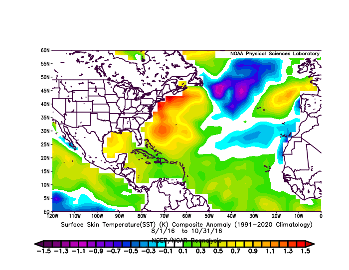
Andy has as analog 2001 based on the pressures and subtropical ssta's warmer than MDR.
https://x.com/AndyHazelton/status/1919381222024765578
2025 Indicators: SST's, MSLP, Shear, SAL, Steering, Instability (Day 16+ Climate Models)
Moderator: S2k Moderators
Forum rules

The posts in this forum are NOT official forecasts and should not be used as such. They are just the opinion of the poster and may or may not be backed by sound meteorological data. They are NOT endorsed by any professional institution or STORM2K. For official information, please refer to products from the National Hurricane Center and National Weather Service.
-
cycloneye

- Admin

- Posts: 149712
- Age: 69
- Joined: Thu Oct 10, 2002 10:54 am
- Location: San Juan, Puerto Rico
Re: 2025 Indicators: SST's, MSLP, Shear, SAL, Steering, Instability (Day 16+ Climate Models)
0 likes
Visit the Caribbean-Central America Weather Thread where you can find at first post web cams,radars
and observations from Caribbean basin members Click Here
and observations from Caribbean basin members Click Here
-
cycloneye
- Admin
- Posts: 149712
- Age: 69
- Joined: Thu Oct 10, 2002 10:54 am
- Location: San Juan, Puerto Rico
Re: 2025 Indicators: SST's, MSLP, Shear, SAL, Steering, Instability (Day 16+ Climate Models)
There has been warming at MDR in the past few days.
Coral Reef data

OISST data

CDAS data

Coral Reef data
OISST data
CDAS data
1 likes
Visit the Caribbean-Central America Weather Thread where you can find at first post web cams,radars
and observations from Caribbean basin members Click Here
and observations from Caribbean basin members Click Here
-
AnnularCane

- S2K Supporter

- Posts: 2964
- Joined: Thu Jun 08, 2006 9:18 am
- Location: Wytheville, VA
Re: 2025 Indicators: SST's, MSLP, Shear, SAL, Steering, Instability (Day 16+ Climate Models)
Is it just me or does there seem to be some disagreement on the MDR? Or is it just finally warming up as some predicted?
0 likes
"But it never rained rain. It never snowed snow. And it never blew just wind. It rained things like soup and juice. It snowed mashed potatoes and green peas. And sometimes the wind blew in storms of hamburgers." -- Judi Barrett, Cloudy with a Chance of Meatballs
-
WeatherBoy2000
- Category 1

- Posts: 463
- Joined: Mon Apr 10, 2023 9:29 am
Re: 2025 Indicators: SST's, MSLP, Shear, SAL, Steering, Instability (Day 16+ Climate Models)
AnnularCane wrote:Is it just me or does there seem to be some disagreement on the MDR? Or is it just finally warming up as some predicted?
According to the Coral reef data, the mdr is currently warming up at a rapid pace:

4 likes

Re: 2025 Indicators: SST's, MSLP, Shear, SAL, Steering, Instability (Day 16+ Climate Models)
AnnularCane wrote:Is it just me or does there seem to be some disagreement on the MDR? Or is it just finally warming up as some predicted?
I'm with you regarding some of these early MDR SST year comparisons. Atm, I see a slightly cool E. Atlantic and an adequately warm tropical Atlantic/Caribbean. Outside of crazy excessive condition anomalies, I think there are other more important factors that ultimately determine the character of each hurricane season. Sure, a cooler Eastern Atlantic in July/August/September may well retard Cape Verde long trackers and cumulative seasonal ACE. That may or may not have implications resulting in further west developing or tracking storm tracks. As for season analogs?? I think some forcasters draw way too much weight from this type of SST analysis when you consider that
1) we're still in early May, and
2) its overly simplistic to consider seasonal outcome and frequency with the focus narrowly considering a year with excessive high SST's verses a year depicting just "warm anomalies".
3) ENSO conditions are essentially neutral and W Atlantic SST's appear forecast to be adequately warm.
Bottom line, I think it's a stretch to draw too much from this alone. I have to believe that one or two more important factors will play a bigger role toward this season's activity being suppressed or excessive.... OR simply average.
8 likes
Andy D
(For official information, please refer to the NHC and NWS products.)
(For official information, please refer to the NHC and NWS products.)
-
Category5Kaiju

- Category 5

- Posts: 4345
- Joined: Thu Dec 24, 2020 12:45 pm
- Location: Seattle during the summer, Phoenix during the winter
Re: 2025 Indicators: SST's, MSLP, Shear, SAL, Steering, Instability (Day 16+ Climate Models)
chaser1 wrote:AnnularCane wrote:Is it just me or does there seem to be some disagreement on the MDR? Or is it just finally warming up as some predicted?
I'm with you regarding some of these early MDR SST year comparisons. Atm, I see a slightly cool E. Atlantic and an adequately warm tropical Atlantic/Caribbean. Outside of crazy excessive condition anomalies, I think there are other more important factors that ultimately determine the character of each hurricane season. Sure, a cooler Eastern Atlantic in July/August/September may well retard Cape Verde long trackers and cumulative seasonal ACE. That may or may not have implications resulting in further west developing or tracking storm tracks. As for season analogs?? I think some forcasters draw way too much weight from this type of SST analysis when you consider that
1) we're still in early May, and
2) its overly simplistic to consider seasonal outcome and frequency with the focus narrowly considering a year with excessive high SST's verses a year depicting just "warm anomalies".
3) ENSO conditions are essentially neutral and W Atlantic SST's appear forecast to be adequately warm.
Bottom line, I think it's a stretch to draw too much from this alone. I have to believe that one or two more important factors will play a bigger role toward this season's activity being suppressed or excessive.... OR simply average.
So, remember last year? Yes, when August and early September were eerily quiet and people began doubting the season? The tropical Atlantic was scorching, but the upper level patterns/conditions simply weren't conducive to cyclone formation. Or the times when Florence, Michael, and Lorenzo attained peak intensity over waters that were in the low 80s F? And Pablo 2019 and Epsilon 2020 becoming hurricanes over waters below 80 F?
You can have boiling waters, but if there's a lot of shear and dry air, you're not going to get anything. You can have rather chilly waters, but if the upper level conditions are favorable, you'll get something. And remember, on a sst anomaly map, when you see white or pale blue in the tropics during hurricane season, that likely would still imply waters that are in the low 80s, meaning enough to support TCs, even powerful ones. Yes, warm ssts are absolutely a good thing for TCs. But they're not the entire picture.
10 likes
Unless explicitly stated, all information in my posts is based on my own opinions and observations. Tropical storms and hurricanes can be extremely dangerous. Refer to an accredited weather research agency or meteorologist if you need to make serious decisions regarding an approaching storm.

Re: 2025 Indicators: SST's, MSLP, Shear, SAL, Steering, Instability (Day 16+ Climate Models)
Category5Kaiju wrote:chaser1 wrote:AnnularCane wrote:Is it just me or does there seem to be some disagreement on the MDR? Or is it just finally warming up as some predicted?
I'm with you regarding some of these early MDR SST year comparisons. Atm, I see a slightly cool E. Atlantic and an adequately warm tropical Atlantic/Caribbean. Outside of crazy excessive condition anomalies, I think there are other more important factors that ultimately determine the character of each hurricane season. Sure, a cooler Eastern Atlantic in July/August/September may well retard Cape Verde long trackers and cumulative seasonal ACE. That may or may not have implications resulting in further west developing or tracking storm tracks. As for season analogs?? I think some forcasters draw way too much weight from this type of SST analysis when you consider that
1) we're still in early May, and
2) its overly simplistic to consider seasonal outcome and frequency with the focus narrowly considering a year with excessive high SST's verses a year depicting just "warm anomalies".
3) ENSO conditions are essentially neutral and W Atlantic SST's appear forecast to be adequately warm.
Bottom line, I think it's a stretch to draw too much from this alone. I have to believe that one or two more important factors will play a bigger role toward this season's activity being suppressed or excessive.... OR simply average.
So, remember last year? Yes, when August and early September were eerily quiet and people began doubting the season? The tropical Atlantic was scorching, but the upper level patterns/conditions simply weren't conducive to cyclone formation. Or the times when Florence, Michael, and Lorenzo attained peak intensity over waters that were in the low 80s F? And Pablo 2019 and Epsilon 2020 becoming hurricanes over waters below 80 F?
You can have boiling waters, but if there's a lot of shear and dry air, you're not going to get anything. You can have rather chilly waters, but if the upper level conditions are favorable, you'll get something. And remember, on a sst anomaly map, when you see white or pale blue in the tropics during hurricane season, that likely would still imply waters that are in the low 80s, meaning enough to support TCs, even powerful ones. Yes, warm ssts are absolutely a good thing for TCs. But they're not the entire picture.
You're right. But 2024 was a season that the MJO mattered and was a strong signal. Unfavorable MJO during the peak was the reason. Otherwise, as you said, you can have a lot of things in place but end up with nothing.
2 likes
-
cycloneye
- Admin
- Posts: 149712
- Age: 69
- Joined: Thu Oct 10, 2002 10:54 am
- Location: San Juan, Puerto Rico
Re: 2025 Indicators: SST's, MSLP, Shear, SAL, Steering, Instability (Day 16+ Climate Models)
4 likes
Visit the Caribbean-Central America Weather Thread where you can find at first post web cams,radars
and observations from Caribbean basin members Click Here
and observations from Caribbean basin members Click Here

Re: 2025 Indicators: SST's, MSLP, Shear, SAL, Steering, Instability (Day 16+ Climate Models)
Honestly, we've been on a streak of "above-average" seasons (in activity, impact or both) for so long, that it's hard to imagine actually having an average or below-average season.
Among 9 consecutive seasons since 2016, only one would be classified as near-average by ACE: 2022. Even that season didn't feel near-normal after the fact, due to the destruction from Fiona and Ian. All other 8 seasons met the above-average ACE threshold of 126.1, with many being just as bad in human impacts.
Crucially, this "near-streak" happened despite all kinds of negative conditions that (some) people expect to lead to inactive seasons:
Below is a GIF loop of Aug-Oct SSTAs in these years. In my amateur eyes, very few of these SSTA profiles would scream above-average by itself, in view of the negative factors that are often thrown around. The closest self-evident ones are probably 2017, 2023 and 2024, but each of their SSTA profiles has arguments against high activity, including the El Nino for 2023.
(Note that these plots use 1991-2020 climo, which is higher than the 1981-2020 that's still used on a few sites, including Tropical Tidbits.
(As part of what I was suggesting, I'd really appreciate some more clarity on how "warm subtropics" is actually defined. There's a clear-cut definition for the tropics/MDR, but it seems that people have used the "warm subtropics" term to describe either 20N-30N, 30N-40N or even further north, and either the western or eastern halves of the basin. I would have expected different effects from each of these regions, and IIRC people had discussed effects of "western subtropics" vs. "eastern subtropics" before. As it is, though, everything seems to be lumped together, inviting critics of warm subtropics pretty much every year except 2023.)
Among 9 consecutive seasons since 2016, only one would be classified as near-average by ACE: 2022. Even that season didn't feel near-normal after the fact, due to the destruction from Fiona and Ian. All other 8 seasons met the above-average ACE threshold of 126.1, with many being just as bad in human impacts.
Crucially, this "near-streak" happened despite all kinds of negative conditions that (some) people expect to lead to inactive seasons:
- El Nino years: 2016, 2018, 2023
- Cold MDR SSTs: 2018, 2021, arguably even 2020?
- Warm subtropics that often outshined deep tropics (which people always say leads to stability issues nowadays): 2016, 2018, 2019, 2020, 2022 (& arguably 2021 and 2024)
- Cold Canary Current: 2018, 2022 (& arguably 2020 and 2021)
- Cold waters right off the coast of Africa (which some Twitter mets suspected to be the reason for Sep 2024's inactivity): 2018, 2019, 2021, 2022, 2024
Below is a GIF loop of Aug-Oct SSTAs in these years. In my amateur eyes, very few of these SSTA profiles would scream above-average by itself, in view of the negative factors that are often thrown around. The closest self-evident ones are probably 2017, 2023 and 2024, but each of their SSTA profiles has arguments against high activity, including the El Nino for 2023.
(Note that these plots use 1991-2020 climo, which is higher than the 1981-2020 that's still used on a few sites, including Tropical Tidbits.
(As part of what I was suggesting, I'd really appreciate some more clarity on how "warm subtropics" is actually defined. There's a clear-cut definition for the tropics/MDR, but it seems that people have used the "warm subtropics" term to describe either 20N-30N, 30N-40N or even further north, and either the western or eastern halves of the basin. I would have expected different effects from each of these regions, and IIRC people had discussed effects of "western subtropics" vs. "eastern subtropics" before. As it is, though, everything seems to be lumped together, inviting critics of warm subtropics pretty much every year except 2023.)
Last edited by Teban54 on Thu May 08, 2025 12:44 am, edited 1 time in total.
8 likes
TC naming lists: retirements and intensity
Most aggressive Advisory #1's in North Atlantic (cr. kevin for starting the list)
Most aggressive Advisory #1's in North Atlantic (cr. kevin for starting the list)
-
cycloneye
- Admin
- Posts: 149712
- Age: 69
- Joined: Thu Oct 10, 2002 10:54 am
- Location: San Juan, Puerto Rico
Re: 2025 Indicators: SST's, MSLP, Shear, SAL, Steering, Instability (Day 16+ Climate Models)
More closer to land developments than long trackers CV ones according to this.
https://x.com/BenNollWeather/status/1919893114535477342
https://x.com/BenNollWeather/status/1919893114535477342
0 likes
Visit the Caribbean-Central America Weather Thread where you can find at first post web cams,radars
and observations from Caribbean basin members Click Here
and observations from Caribbean basin members Click Here
-
julius davis
- Tropical Wave

- Posts: 7
- Joined: Sun May 04, 2025 12:11 pm
Re: 2025 Indicators: SST's, MSLP, Shear, SAL, Steering, Instability (Day 16+ Climate Models)
cycloneye wrote:More closer to land developments than long trackers CV ones according to this.
https://x.com/BenNollWeather/status/1919893114535477342
how do you post maps and photos on storm2k?
0 likes
-
cycloneye
- Admin
- Posts: 149712
- Age: 69
- Joined: Thu Oct 10, 2002 10:54 am
- Location: San Juan, Puerto Rico
Re: 2025 Indicators: SST's, MSLP, Shear, SAL, Steering, Instability (Day 16+ Climate Models)
The NMME may forecast is not bullish noy only for the NATL.
https://x.com/AndyHazelton/status/1920133584146354231
https://x.com/AndyHazelton/status/1920133584146354231
0 likes
Visit the Caribbean-Central America Weather Thread where you can find at first post web cams,radars
and observations from Caribbean basin members Click Here
and observations from Caribbean basin members Click Here
-
cycloneye
- Admin
- Posts: 149712
- Age: 69
- Joined: Thu Oct 10, 2002 10:54 am
- Location: San Juan, Puerto Rico
Re: 2025 Indicators: SST's, MSLP, Shear, SAL, Steering, Instability (Day 16+ Climate Models)
julius davis wrote:cycloneye wrote:More closer to land developments than long trackers CV ones according to this.
https://x.com/BenNollWeather/status/1919893114535477342
how do you post maps and photos on storm2k?
Where you see the img tool, put the link at the middle.
0 likes
Visit the Caribbean-Central America Weather Thread where you can find at first post web cams,radars
and observations from Caribbean basin members Click Here
and observations from Caribbean basin members Click Here
-
julius davis
- Tropical Wave
- Posts: 7
- Joined: Sun May 04, 2025 12:11 pm
Re: 2025 Indicators: SST's, MSLP, Shear, SAL, Steering, Instability (Day 16+ Climate Models)
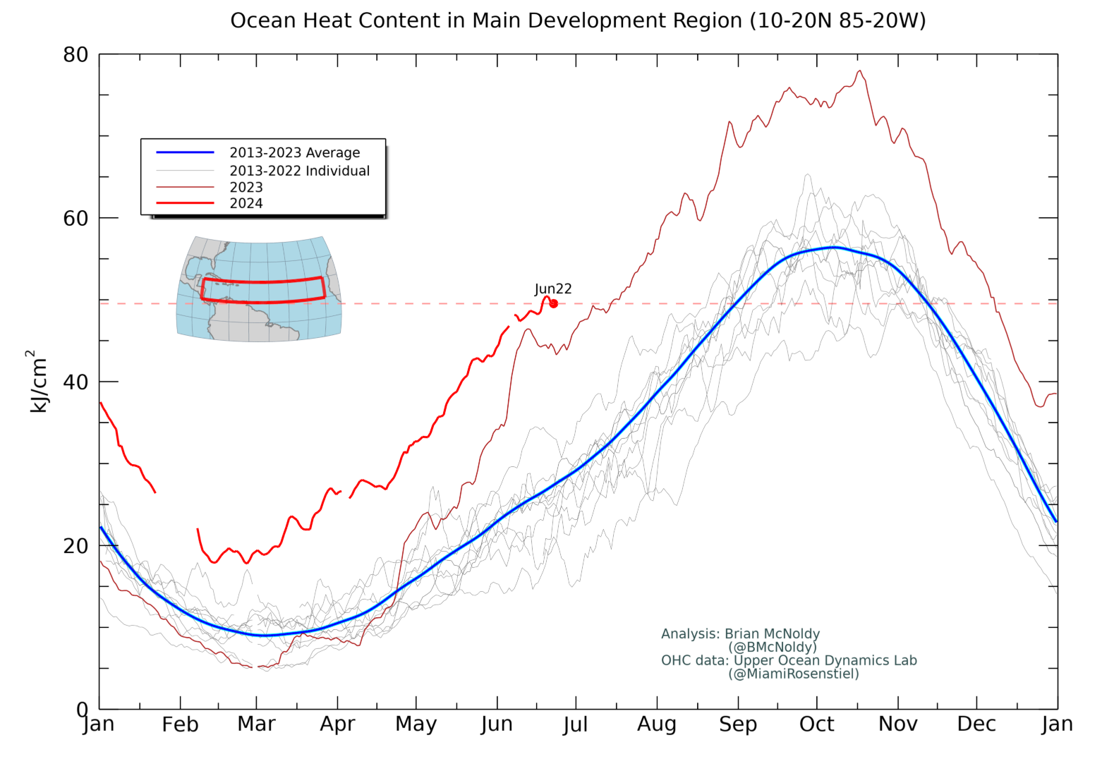
 OHC is running well above average
5 likes
-
julius davis
- Tropical Wave
- Posts: 7
- Joined: Sun May 04, 2025 12:11 pm
-
DorkyMcDorkface

- Category 5
- Posts: 1043
- Age: 28
- Joined: Mon Sep 30, 2019 1:32 pm
- Location: Mid-Atlantic
Re: 2025 Indicators: SST's, MSLP, Shear, SAL, Steering, Instability (Day 16+ Climate Models)
A "mixed signal" in the truest sense of the word...
https://x.com/AndyHazelton/status/1920591119026729175
https://x.com/AndyHazelton/status/1920591119026729175
1 likes
Please note the thoughts expressed by this account are solely those of the user and are from a hobbyist perspective. For more comprehensive analysis, consult an actual professional meteorologist or meteorological agency.
Floyd 1999 | Isabel 2003 | Hanna 2008 | Irene 2011 | Sandy 2012 | Isaias 2020
-
cycloneye
- Admin
- Posts: 149712
- Age: 69
- Joined: Thu Oct 10, 2002 10:54 am
- Location: San Juan, Puerto Rico
Re: 2025 Indicators: SST's, MSLP, Shear, SAL, Steering, Instability (Day 16+ Climate Models)
@DerekOrtt
This is not what we want to see. This is full on 2023 May warming
https://x.com/DerekOrtt/status/1920710002274177332
This is not what we want to see. This is full on 2023 May warming
https://x.com/DerekOrtt/status/1920710002274177332
0 likes
Visit the Caribbean-Central America Weather Thread where you can find at first post web cams,radars
and observations from Caribbean basin members Click Here
and observations from Caribbean basin members Click Here

Re: 2025 Indicators: SST's, MSLP, Shear, SAL, Steering, Instability (Day 16+ Climate Models)
Category5Kaiju wrote:chaser1 wrote:AnnularCane wrote:Is it just me or does there seem to be some disagreement on the MDR? Or is it just finally warming up as some predicted?
I'm with you regarding some of these early MDR SST year comparisons. Atm, I see a slightly cool E. Atlantic and an adequately warm tropical Atlantic/Caribbean. Outside of crazy excessive condition anomalies, I think there are other more important factors that ultimately determine the character of each hurricane season. Sure, a cooler Eastern Atlantic in July/August/September may well retard Cape Verde long trackers and cumulative seasonal ACE. That may or may not have implications resulting in further west developing or tracking storm tracks. As for season analogs?? I think some forcasters draw way too much weight from this type of SST analysis when you consider that
1) we're still in early May, and
2) its overly simplistic to consider seasonal outcome and frequency with the focus narrowly considering a year with excessive high SST's verses a year depicting just "warm anomalies".
3) ENSO conditions are essentially neutral and W Atlantic SST's appear forecast to be adequately warm.
Bottom line, I think it's a stretch to draw too much from this alone. I have to believe that one or two more important factors will play a bigger role toward this season's activity being suppressed or excessive.... OR simply average.
So, remember last year? Yes, when August and early September were eerily quiet and people began doubting the season? The tropical Atlantic was scorching, but the upper level patterns/conditions simply weren't conducive to cyclone formation. Or the times when Florence, Michael, and Lorenzo attained peak intensity over waters that were in the low 80s F? And Pablo 2019 and Epsilon 2020 becoming hurricanes over waters below 80 F?
You can have boiling waters, but if there's a lot of shear and dry air, you're not going to get anything. You can have rather chilly waters, but if the upper level conditions are favorable, you'll get something. And remember, on a sst anomaly map, when you see white or pale blue in the tropics during hurricane season, that likely would still imply waters that are in the low 80s, meaning enough to support TCs, even powerful ones. Yes, warm ssts are absolutely a good thing for TCs. But they're not the entire picture.
Yes, I remember last year when we had an early hurricane Beryl and reminded my area that we need to prepared much earlier than normal.
0 likes
Alicia, Rita, Ike, Harvey and Beryl...moved to Splendora lol
-
tolakram
- Admin
- Posts: 20186
- Age: 62
- Joined: Sun Aug 27, 2006 8:23 pm
- Location: Florence, KY (name is Mark)
Re: 2025 Indicators: SST's, MSLP, Shear, SAL, Steering, Instability (Day 16+ Climate Models)
Oh, is there a spring barrier this year? Apologies for the sarcasm, but every May we seem to go through this shock and awe. 
1 likes
M a r k
- - - - -
Join us in chat: Storm2K Chatroom Invite. Android and IOS apps also available.
The posts in this forum are NOT official forecasts and should not be used as such. Posts are NOT endorsed by any professional institution or STORM2K.org. For official information and forecasts, please refer to NHC and NWS products.
Who is online
Users browsing this forum: AnnularCane and 216 guests