2020 Global Model Runs Discussion (Out thru day 16)

This is the general tropical discussion area. Anyone can take their shot at predicting a storms path.

Moderator: S2k Moderators

Forum rules

The posts in this forum are NOT official forecasts and should not be used as such. They are just the opinion of the poster and may or may not be backed by sound meteorological data. They are NOT endorsed by any professional institution or STORM2K. For official information, please refer to products from the National Hurricane Center and National Weather Service.

Help Support Storm2K
Message
Author
xironman
S2K Supporter
S2K Supporter
Posts: 2522
Joined: Sun Jun 10, 2007 4:53 pm
Location: NoVA

Re: 2020 Global Model Runs Discussion (Out thru day 16)

#1841 Postby xironman » Tue Sep 01, 2020 4:30 pm

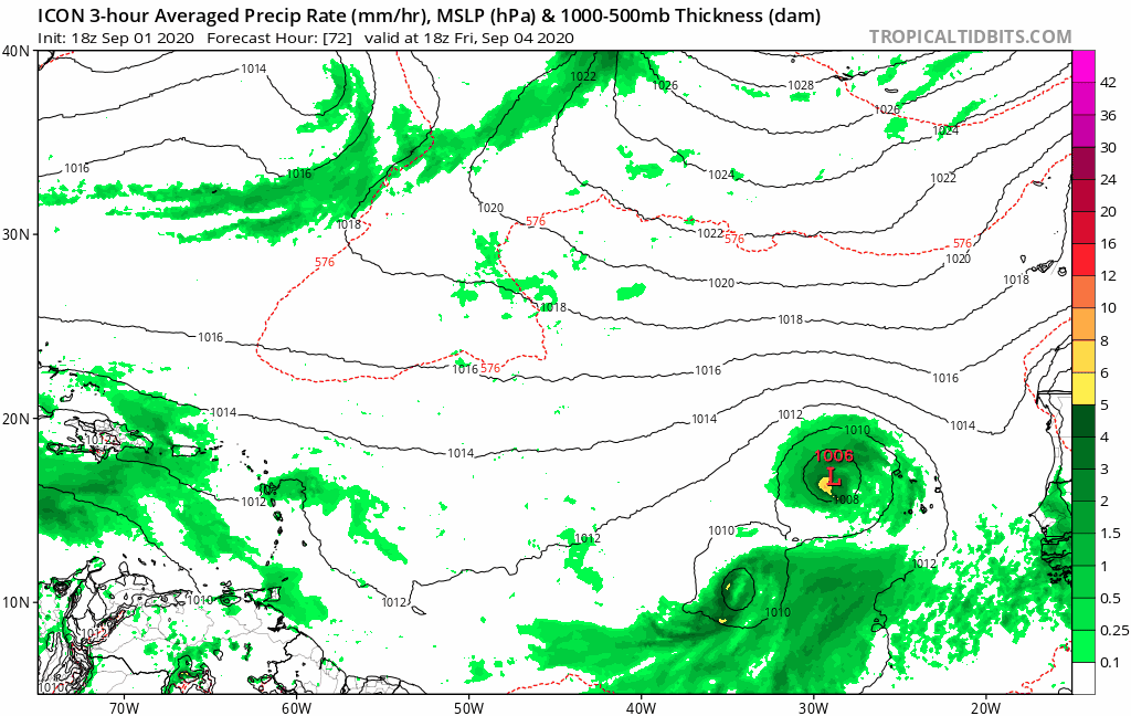
Frank2 wrote:I'm going with the GFS showing a very active trough pattern over the next few weeks. I know two Canadians who live near Calgary and Yellowknife - both live in rural areas and said the cold is already making itself felt, so perhaps sign of an early Winter and per the GFS it seems the first fronts are coming south in the next few weeks. That pattern often results in a shortened tropical cyclone season.

Frank


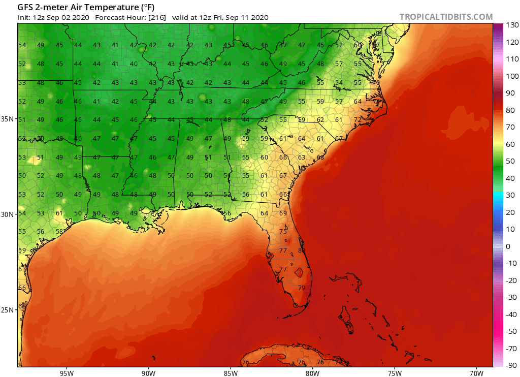
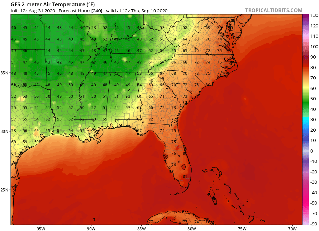
Today is the start of meteorological fall so it is good they feel the change. I am getting sick of the heat.
1 likes   

LarryWx
S2K Supporter
S2K Supporter
Posts: 6319
Joined: Sun Sep 07, 2003 2:04 pm
Location: GA

Re: 2020 Global Model Runs Discussion (Out thru day 16)

#1842 Postby LarryWx » Tue Sep 01, 2020 4:32 pm

SFLcane wrote:
LarryWx wrote:Continuing further out on the 12Z EPS from what NDG just posted: suggests the CONUS, Bahamas, and Bermuda should be wary about midmonth from the wave coming off the African coast about now:

https://i.imgur.com/F2SeZ4A.png


EPS trended a bit SW from 00z but still implying a potential threat to Bermuda.


Yeah because the WAR as I assume you realize is further west on the 12Z vs the 0Z EPS. As often occurs with ensemble means due to often going back and forth, the WAR may very well go back east on the next run and reduce the threat to the CONUS and Bahamas back down to where it was. But that remains to be seen. If instead 0Z holds serve or goes even further west with the WAR, that could mean trouble for CONUS/Bahamas. (Bermuda at risk, regardless imo).

I'm a bit worried it will remain or maybe come even further west because we're in La Nina and also because the last few years due to very warm Indonesian waters have lead to a further west WAR/SE ridge/warmer SE even in El Nino. It has been relentless and has really weakened our winters.
1 likes   
Personal Forecast Disclaimer:
The posts in this forum are NOT official forecasts and should not be used as such. They are just the opinion of the poster and may or may not be backed by sound meteorological data. They are NOT endorsed by any professional institution or storm2k.org. For official information, please refer to the NHC and NWS products.

lovingseason2013
Tropical Depression
Tropical Depression
Posts: 71
Joined: Sat Oct 12, 2013 7:54 am
Location: Pensacola, FL

Re: 2020 Global Model Runs Discussion (Out thru day 16)

#1843 Postby lovingseason2013 » Tue Sep 01, 2020 5:15 pm

gatorcane wrote:If the GFS trough verifies, and that is a big if, looks like we could see some of the SSTs cool down along the northern Gulf coast with lows in the mid 50s:

https://i.postimg.cc/X7KHchxf/gfs-T2m-seus-41.png


I dont think this is going to verify. It is blazing hot and has to be warming up those upwelled waters from Marco and Laura.
1 likes   

User avatar
NDG
S2K Supporter
S2K Supporter
Posts: 15446
Joined: Sun Jul 09, 2006 10:14 pm
Location: Orlando, FL

Re: 2020 Global Model Runs Discussion (Out thru day 16)

#1844 Postby NDG » Tue Sep 01, 2020 6:41 pm

TheStormExpert wrote:
NDG wrote:Euro ensembles show potentially 2-3 systems at the same time over in the Atlantic basin during the peak of the season.

https://i.imgur.com/LSAtgYI.png

Besides the current two?


Yes, besides the current two.
This is when I start believing its 7-10 day range of development east of the Lesser Antilles because the SAL starts subsiding like it usually does this time of the year. There is still some forecasted to come out in between AEWs but nothing like in July-August.
1 likes   

User avatar
1900hurricane
Category 5
Category 5
Posts: 6059
Age: 34
Joined: Fri Feb 06, 2015 12:04 pm
Location: Houston, TX
Contact:

Re: 2020 Global Model Runs Discussion (Out thru day 16)

#1845 Postby 1900hurricane » Tue Sep 01, 2020 7:05 pm

These guidance freakouts remind me of jumbo monsoon trough setups from the WPac. It just becomes so hard to model once the entire thing goes into barotropic breakdown.
0 likes   
Contract Meteorologist. TAMU & MSST. Fiercely authentic, one of a kind. We are all given free will, so choose a life meant to be lived. We are the Masters of our own Stories.
Opinions expressed are mine alone.

Follow me on Twitter at @1900hurricane : Read blogs at https://1900hurricane.wordpress.com/

USTropics
Professional-Met
Professional-Met
Posts: 2659
Joined: Sun Aug 12, 2007 3:45 am
Location: Florida State University

Re: 2020 Global Model Runs Discussion (Out thru day 16)

#1846 Postby USTropics » Tue Sep 01, 2020 7:30 pm

Chances of TC genesis has increased to nearly 90% (consensus of CMC/UKMET) in the next 5 days:
Image

ECMWF ensembles are also starting to pickup on a few systems coming out of the deep MDR:
Image
0 likes   

User avatar
SFLcane
S2K Supporter
S2K Supporter
Posts: 10163
Age: 47
Joined: Sat Jun 05, 2010 1:44 pm
Location: Lake Worth Florida

Re: 2020 Global Model Runs Discussion (Out thru day 16)

#1847 Postby SFLcane » Tue Sep 01, 2020 7:35 pm

Image
3 likes   

User avatar
ElectricStorm
Category 5
Category 5
Posts: 5049
Age: 24
Joined: Tue Aug 13, 2019 11:23 pm
Location: Skiatook, OK / Norman, OK

Re: 2020 Global Model Runs Discussion (Out thru day 16)

#1848 Postby ElectricStorm » Tue Sep 01, 2020 7:38 pm

5 likes   
B.S Meteorology, University of Oklahoma '25

Please refer to the NHC, NWS, or SPC for official information.

User avatar
aspen
Category 5
Category 5
Posts: 8818
Joined: Sat Oct 12, 2019 7:10 pm
Location: Connecticut, USA

Re: 2020 Global Model Runs Discussion (Out thru day 16)

#1849 Postby aspen » Tue Sep 01, 2020 7:42 pm

The 18z GFS is slightly better with showing TC development. The 10/60 wave develops into a weak TC that becomes a hurricane in the super long range, the following wave becomes a quickly recurving hurricane, and it even shows something trying to form in the Gulf at the end of the run just like the GFS-Para.
0 likes   
Irene '11 Sandy '12 Hermine '16 5/15/2018 Derecho Fay '20 Isaias '20 Elsa '21 Henri '21 Ida '21

I am only a meteorology enthusiast who knows a decent amount about tropical cyclones. Look to the professional mets, the NHC, or your local weather office for the best information.

User avatar
toad strangler
S2K Supporter
S2K Supporter
Posts: 4543
Joined: Sun Jul 28, 2013 3:09 pm
Location: Earth
Contact:

Re: 2020 Global Model Runs Discussion (Out thru day 16)

#1850 Postby toad strangler » Tue Sep 01, 2020 7:48 pm


Verbatim on this ICON run it happens WAY out East but ya, noticed it.
0 likes   

User avatar
blp
Category 5
Category 5
Posts: 2840
Age: 46
Joined: Thu Sep 09, 2004 7:51 pm
Location: Miami, FL
Contact:

Re: 2020 Global Model Runs Discussion (Out thru day 16)

#1851 Postby blp » Tue Sep 01, 2020 9:22 pm

Is it me or is there some agreement here one run finally. Probably won't last.

12z Euro
Image

18z GFS Para
Image
8 likes   
The following post is NOT an official forecast and should not be used as such. It is just the opinion of the poster and may or may not be backed by sound meteorological data. It is NOT endorsed by any professional institution including storm2k.org For Official Information please refer to the NHC and NWS products.

St0rmTh0r
Category 1
Category 1
Posts: 369
Joined: Tue Jul 14, 2020 8:04 pm

Re: 2020 Global Model Runs Discussion (Out thru day 16)

#1852 Postby St0rmTh0r » Tue Sep 01, 2020 10:47 pm

blp wrote:Is it me or is there some agreement here one run finally. Probably won't last.

12z Euro
https://i.ibb.co/NyxqXMP/ecmwf-uv850-vort-eatl-11.png

18z GFS Para
https://www.tropicaltidbits.com/analysis/models/gfsp/2020090118/gfsp_z850_vort_eatl_41.png

One thing is for sure theres about to be some insane activity in the coming weeks
0 likes   

User avatar
chaser1
S2K Supporter
S2K Supporter
Posts: 5475
Age: 64
Joined: Sat Oct 15, 2005 5:59 pm
Location: Longwood, Fl

Re: 2020 Global Model Runs Discussion (Out thru day 16)

#1853 Postby chaser1 » Tue Sep 01, 2020 10:51 pm

blp wrote:Is it me or is there some agreement here one run finally. Probably won't last.

12z Euro
https://i.ibb.co/NyxqXMP/ecmwf-uv850-vort-eatl-11.png

18z GFS Para
https://www.tropicaltidbits.com/analysis/models/gfsp/2020090118/gfsp_z850_vort_eatl_41.png


That's a little scary, ESPECIALLY during a year where even singular model support has been largely absent. It goes without saying that this may be a code-red in the making.
0 likes   
Andy D

(For official information, please refer to the NHC and NWS products.)

supercane4867
Category 5
Category 5
Posts: 4966
Joined: Wed Nov 14, 2012 10:43 am

Re: 2020 Global Model Runs Discussion (Out thru day 16)

#1854 Postby supercane4867 » Wed Sep 02, 2020 5:51 am

06z GFS thinks we will have Teddy by September 10

Image
0 likes   

User avatar
NDG
S2K Supporter
S2K Supporter
Posts: 15446
Joined: Sun Jul 09, 2006 10:14 pm
Location: Orlando, FL

Re: 2020 Global Model Runs Discussion (Out thru day 16)

#1855 Postby NDG » Wed Sep 02, 2020 6:05 am

Big differences continue between the GFS/GFS-Para and Euro on troughiness next week.
GFS still shows quite a strong and deep trough coming down the plains into the MS river valley with strong westerly UL winds all the way down to the GOM, while the Euro show a much weaker trough digging down towards the Rockies then cutting off near the Four Corners with strong ridging remaining over the SE US.
The CMC is similar to the Euro.
I rather go with a combination of the EPS & GEFS Ensembles when it comes to a sypnotic set up in that range.

Image
Image
Image
Image
Image
0 likes   

User avatar
northjaxpro
S2K Supporter
S2K Supporter
Posts: 8900
Joined: Mon Sep 27, 2010 11:21 am
Location: Jacksonville, FL

Re: 2020 Global Model Runs Discussion (Out thru day 16)

#1856 Postby northjaxpro » Wed Sep 02, 2020 6:17 am

:uarrow: With a solid +NAO signal being forecast up through to about mid-September, I would put my money on the EPS ensembles at this juncture.
7 likes   
NEVER, EVER SAY NEVER in the tropics and weather in general, and most importantly, with life itself!!

________________________________________________________________________________________

Fay 2008 Beryl 2012 Debby 2012 Colin 2016 Hermine 2016 Julia 2016 Matthew 2016 Irma 2017 Dorian 2019

User avatar
aspen
Category 5
Category 5
Posts: 8818
Joined: Sat Oct 12, 2019 7:10 pm
Location: Connecticut, USA

Re: 2020 Global Model Runs Discussion (Out thru day 16)

#1857 Postby aspen » Wed Sep 02, 2020 10:08 am

Today's 00z Euro run has one hell of a wave train over the next 9 days. Nothing too strong, but then again, the Euro isn't great with intensity forecasts, and the fact that it's showing this much is impressive, given its poor track record this year.
Image
Image
Image
Image
Image
Image
Image

The 06z GFS shows a similar solution as the Euro next Wednesday.
Image
7 likes   
Irene '11 Sandy '12 Hermine '16 5/15/2018 Derecho Fay '20 Isaias '20 Elsa '21 Henri '21 Ida '21

I am only a meteorology enthusiast who knows a decent amount about tropical cyclones. Look to the professional mets, the NHC, or your local weather office for the best information.

User avatar
NDG
S2K Supporter
S2K Supporter
Posts: 15446
Joined: Sun Jul 09, 2006 10:14 pm
Location: Orlando, FL

Re: 2020 Global Model Runs Discussion (Out thru day 16)

#1858 Postby NDG » Wed Sep 02, 2020 11:34 am

12z GFS says hello Fall goodbye peak of the hurricane season. :lol:

Image
1 likes   

User avatar
gatorcane
S2K Supporter
S2K Supporter
Posts: 23691
Age: 47
Joined: Sun Mar 13, 2005 3:54 pm
Location: Boca Raton, FL

Re: 2020 Global Model Runs Discussion (Out thru day 16)

#1859 Postby gatorcane » Wed Sep 02, 2020 11:37 am

NDG wrote:12z GFS says hello Fall goodbye peak of the hurricane season. :lol:

https://i.imgur.com/WVbTNDj.png


You beat me to it, shows 40s down to the northern Gulf coast :cold: :eek:

Image
0 likes   

User avatar
NDG
S2K Supporter
S2K Supporter
Posts: 15446
Joined: Sun Jul 09, 2006 10:14 pm
Location: Orlando, FL

Re: 2020 Global Model Runs Discussion (Out thru day 16)

#1860 Postby NDG » Wed Sep 02, 2020 11:47 am

GFS says the GOM closed for tropical business next week, even into parts of the Caribbean, it will either an epic failure or a king among models. Time will tell, but it has surely been persistent on it.

Image
0 likes   


Return to “Talkin' Tropics”

Who is online

Users browsing this forum: TampaWxLurker and 35 guests