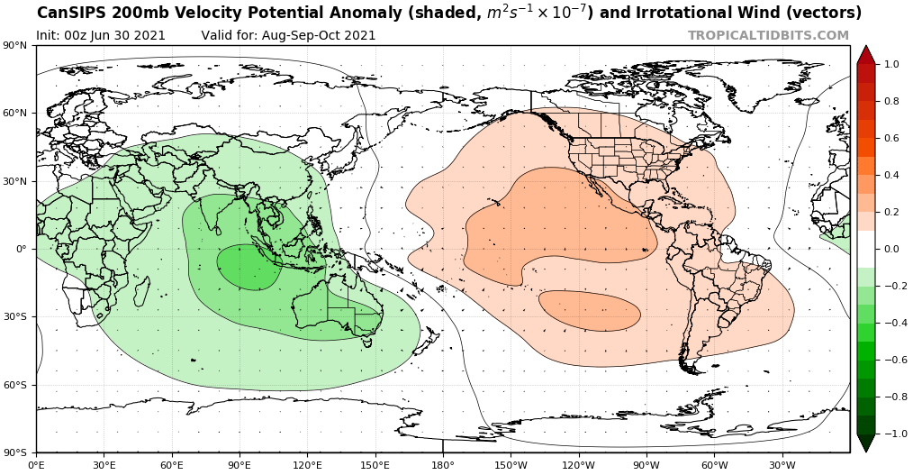
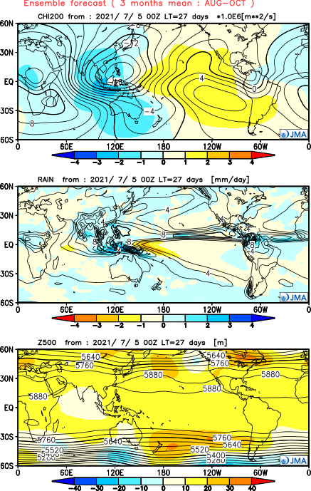
AlphaToOmega wrote:Come peak season, the EPAC cell is going to be non-existent.
https://i.postimg.cc/kg1w0nwY/cansips-chi200-Mean-month-global-2.png
https://i.postimg.cc/JhsKm92r/Y202107-D0500-gl0.png
Those forecasts are a month old.
Moderator: S2k Moderators


AlphaToOmega wrote:Come peak season, the EPAC cell is going to be non-existent.
https://i.postimg.cc/kg1w0nwY/cansips-chi200-Mean-month-global-2.png
https://i.postimg.cc/JhsKm92r/Y202107-D0500-gl0.png


cycloneye wrote:This from CPC global hazards:Only the OLR anomalies are less consistent with a canonical major MJO event, as much of the enhanced convection is currently developing away from the Equator across the Monsoon regions of South and Southeast Asia and over the Northwest Pacific. A time-longitude analysis of the OLR field shows a robust Kelvin wave crossing the East Pacific, which is currently still near the leading edge of the MJO enhanced convective envelope but will soon separate. As this occurs, the strong projections on the MJO indices may begin to weaken due to the destructive interference. Additionally, an evolving SST-driven low-frequency state across the Pacific favors suppressed convection, which may also be limiting the extent of the MJO enhanced phase. Accordingly, dynamical model RMM-index forecasts all show a weakening signal, with most models depicting a rapid jump towards the Indian Ocean as the Kelvin wave becomes the more prominent feature while the slower evolving MJO weakens over the Pacific. Therefore, as the forecast lead time increases, the role of the MJO in the evolution of the tropical convective pattern becomes more uncertain. Dynamical models do show an enhancement of the North Pacific ITCZ which will likely tie into increased tropical cyclone activity. Any MJO influence on Atlantic tropical cyclone activity would largely occur near the end of or beyond the Week-2 period, if at all.
https://www.cpc.ncep.noaa.gov/products/ ... /ghazards/
aspen wrote:cycloneye wrote:This from CPC global hazards:Only the OLR anomalies are less consistent with a canonical major MJO event, as much of the enhanced convection is currently developing away from the Equator across the Monsoon regions of South and Southeast Asia and over the Northwest Pacific. A time-longitude analysis of the OLR field shows a robust Kelvin wave crossing the East Pacific, which is currently still near the leading edge of the MJO enhanced convective envelope but will soon separate. As this occurs, the strong projections on the MJO indices may begin to weaken due to the destructive interference. Additionally, an evolving SST-driven low-frequency state across the Pacific favors suppressed convection, which may also be limiting the extent of the MJO enhanced phase. Accordingly, dynamical model RMM-index forecasts all show a weakening signal, with most models depicting a rapid jump towards the Indian Ocean as the Kelvin wave becomes the more prominent feature while the slower evolving MJO weakens over the Pacific. Therefore, as the forecast lead time increases, the role of the MJO in the evolution of the tropical convective pattern becomes more uncertain. Dynamical models do show an enhancement of the North Pacific ITCZ which will likely tie into increased tropical cyclone activity. Any MJO influence on Atlantic tropical cyclone activity would largely occur near the end of or beyond the Week-2 period, if at all.
https://www.cpc.ncep.noaa.gov/products/ ... /ghazards/
So this MJO won’t help the Atlantic get out of the suppressed MJO phase?
It’s so odd to see a season with an early July MDR/ECar hurricane and the earliest 5th named storm on record have such a long gap with the MJO just not helping at all.
MarioProtVI wrote:Shell Mound wrote:USTropics wrote:Definitely has a very monsoonal look, here is total precip for the entire 12z ECMWF run:
https://i.imgur.com/hnH14I1.png
This pattern is virtually identical to last year’s and also contributed to an underwhelming season in the MDR, as most AEWs were too broad and disorganised for most of their trek westward across the MDR, prior to reaching the Lesser Antilles. Currently the C/EPAC look to generate at least two major hurricanes within the next few weeks, along with two or more additional systems. As long as the C/EPAC continue to behave as though we were in +PMM/+PDO/+ENSO the active African monsoon could actually prevent a more active Atlantic season, as systems that would initially struggle to consolidate would then encounter strong VWS over the Caribbean, thanks to the active C/EPAC convection. Sprawling waves that take time to consolidate over the MDR would end up facing shear over the western part of the Atlantic basin. So I disagree with people who say that an active MDR would be better for the islands and other land-masses, given that the MDR tends to produce the majority of upper-end MH landfalls. Currently I am still rather bearish about the prospects of this season, given the fact that the CFSv2 seems to be handling the amplitude and progression of the MJO better than the EPS, while the Atlantic still retains a persistently residual -AMM/-AMO (look at the coolish Canary Current and its refusal to warm up).
A very telling comparison: the WPAC-style monsoonal trough in the Atlantic does practically nothing, while the EPAC monsoon generates multiple hurricanes:
https://twitter.com/AndyHazelton/status/1420509220366168072
https://twitter.com/AndyHazelton/status/1420458814395060226
https://twitter.com/AndyHazelton/status/1420509430450475008
All in all, the indicators suggest that the rising cell over the C/EPAC is going to be more persistent and stronger than many people might expect.
Not buying into the GFS’s EPac major spam. ... The monsoon trough setup could easily fix itself by late August and still contribute to a decent MDR season. Finally, the -AMO look is complete crap...
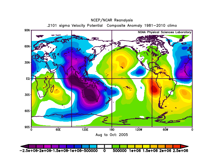
AlphaToOmega wrote:Neither the CanSIPS nor the JMA suggest a -VP EPac cell for ASO, but if one somehow formed, it would not mean much. This is the VP anomaly map for ASO 2005; notice the -VP anomalies in the EPac
https://i.postimg.cc/kGvTvyd6/9r-Svt-H4ev4.png
SFLcane wrote:AlphaToOmega wrote:Neither the CanSIPS nor the JMA suggest a -VP EPac cell for ASO, but if one somehow formed, it would not mean much. This is the VP anomaly map for ASO 2005; notice the -VP anomalies in the EPac
https://i.postimg.cc/kGvTvyd6/9r-Svt-H4ev4.png
Atlantic cell is way stronger though.
aspen wrote:SFLcane wrote:AlphaToOmega wrote:Neither the CanSIPS nor the JMA suggest a -VP EPac cell for ASO, but if one somehow formed, it would not mean much. This is the VP anomaly map for ASO 2005; notice the -VP anomalies in the EPac
https://i.postimg.cc/kGvTvyd6/9r-Svt-H4ev4.png
Atlantic cell is way stronger though.
Isn’t that also the case this year? The EPac cell is so small compared to what the Atlantic/African cell is modeled to be.
SFLcane wrote:Oh! Was not expecting this so now the JMA is shearing the Atlantic to. Hate to say it but it’s good news we could be looking at a rather hostile Atlantic if the CFS and JMA are correct.
I’ll say it 2013 v2.0.
All jokes aside I just don’t know anymore but as always be prepared.
https://twitter.com/bennollweather/status/1420753479908343808
AlphaToOmega wrote:Neither the CanSIPS nor the JMA suggest a -VP EPac cell for ASO
SFLcane wrote:Oh! Was not expecting this so now the JMA is shearing the Atlantic for August. Hate to say it but it’s good news we could be looking at a rather hostile Atlantic if the CFS and JMA are correct.
I just don’t know anymore but as always be prepared
https://twitter.com/bennollweather/status/1420753479908343808
Shell Mound wrote:AlphaToOmega wrote:Neither the CanSIPS nor the JMA suggest a -VP EPac cell for ASO[/url]
Actually, they do, at least early on. Please check the charts. Also, note that the JMA shows below-average MSLP over the EPAC through the end of August.
AlphaToOmega wrote:Come peak season, the EPAC cell is going to be non-existent.
https://i.postimg.cc/kg1w0nwY/cansips-chi200-Mean-month-global-2.png
https://i.postimg.cc/JhsKm92r/Y202107-D0500-gl0.png
SFLcane wrote:Oh! Was not expecting this so now the JMA is shearing the Atlantic for August. Hate to say it but it’s good news we could be looking at a rather hostile Atlantic if the CFS and JMA are correct.
I just don’t know anymore but as always be prepared
https://twitter.com/bennollweather/stat ... 9908343808
AlphaToOmega wrote:Shell Mound wrote:AlphaToOmega wrote:Neither the CanSIPS nor the JMA suggest a -VP EPac cell for ASO[/url]
Actually, they do, at least early on. Please check the charts. Also, note that the JMA shows below-average MSLP over the EPAC through the end of August.AlphaToOmega wrote:Come peak season, the EPAC cell is going to be non-existent.
https://i.postimg.cc/kg1w0nwY/cansips-chi200-Mean-month-global-2.png
https://i.postimg.cc/JhsKm92r/Y202107-D0500-gl0.png
Shell Mound wrote:AlphaToOmega wrote:Shell Mound wrote:Actually, they do, at least early on. Please check the charts. Also, note that the JMA shows below-average MSLP over the EPAC through the end of August.AlphaToOmega wrote:Come peak season, the EPAC cell is going to be non-existent.
https://i.postimg.cc/kg1w0nwY/cansips-chi200-Mean-month-global-2.png
https://i.postimg.cc/JhsKm92r/Y202107-D0500-gl0.png
Current trends favour a strong and dominant -VP signature over the EPAC through the end of August that induces a strong TUTT over most of the Atlantic.
aspen wrote:SFLcane wrote:Oh! Was not expecting this so now the JMA is shearing the Atlantic for August. Hate to say it but it’s good news we could be looking at a rather hostile Atlantic if the CFS and JMA are correct.
I just don’t know anymore but as always be prepared
https://twitter.com/bennollweather/status/1420753479908343808
A developing La Niña…but with reduced shear in the tropical East Pacific and enhanced shear in the tropical Atlantic.
This season has so many mixed signals and strange model outputs it’s just ridiculous.

Users browsing this forum: Kingarabian, Ulf, USTropics and 303 guests
