From the HGX NWS AFD at 2 pm...this snippet
The deterministic run of the GFS is still the most aggressive with
bringing showers, and dare I mention some freezing/frozen
precipitation Wednesday ahead of another fast moving weather system.
This is a bit of an outlier from the other ensemble members, as well
as the ECMWF which keeps this system much farther south. Far too
uncertain to include any mention of this in the forecast, but the
possibility is non-zero for sure- especially across the north.
Global models often underdo the arctic air (speed, depth and
magnitude), so there is still a lot to play out. Thus, we can`t
just completely discount the few models bringing more snow/ice into
the forecast mid week. At this point, we just need to stay tuned!
Texas Winter 2024-2025
Moderator: S2k Moderators
Forum rules
 The posts in this forum are NOT official forecast and should not be used as such. They are just the opinion of the poster and may or may not be backed by sound meteorological data. They are NOT endorsed by any professional institution or STORM2K.

The posts in this forum are NOT official forecast and should not be used as such. They are just the opinion of the poster and may or may not be backed by sound meteorological data. They are NOT endorsed by any professional institution or STORM2K.
-
Tireman4

- S2K Supporter

- Posts: 5903
- Age: 60
- Joined: Fri Jun 30, 2006 1:08 pm
- Location: Humble, Texas
- Contact:
Re: Texas Winter 2024-2025
2 likes
-
Stratton23
- Category 5

- Posts: 3482
- Joined: Fri Jul 21, 2023 10:59 pm
- Location: Katy, Tx
Re: Texas Winter 2024-2025
Not sure why they said the op GFS is an outlier from its ensemble, it definitely is not
3 likes
-
HockeyTx82
- S2K Supporter
- Posts: 2774
- Joined: Tue Oct 27, 2009 11:17 am
- Location: Ponder, TX
Re: Texas Winter 2024-2025
566
FXUS64 KFWD 022148
AFDFWD
Area Forecast Discussion
National Weather Service Fort Worth TX
348 PM CST Thu Jan 2 2025
...New Long Term...
.KEY MESSAGES...
- Near to above-normal temperatures will continue through the
remainder of the week.
- A strong cold front will arrive on Sunday, increasing the
potential for showers with an isolated storm or two possible.
- Arctic air will arrive on Sunday, ushering in the coldest air
of the season thus far. Widespread lows in the 20s are expected
most nights next week.
- Although precipitation chances remain low, confidence has
increased slightly in the winter precipitation potential for mid
next week.
&&
.SHORT TERM... /Issued 1242 PM CST Thu Jan 2 2025/
/Through Friday/
A cool and relatively benign weather regime will persist over
North Texas this afternoon through Friday as a dry upper level
northwesterly flow pattern dominates the region. Weak southerly
surface flow will continue through this evening, but a backing of
the winds to an east and northeast direction can be expected later
tonight, as a weak cold front pushes through the area. The weak
cold advection associated with the passage of this boundary will
retard Friday`s highs slightly, compared with today`s values.
A substantial mass of low clouds covers the southern portion of
the forecast area at midday, owing to a pool of high moisture in
the lower portion of the atmosphere, and some weak isentropic
ascent. Portions of this mass will thin out and mix just a bit
this afternoon, yielding partly sunny conditions over Central
Texas after 3-4 pm. Areas of stratus are likely to redevelop and
expand across much of the area early tomorrow morning, and this
will persist through most of the morning. Elsewhere, sunny skies
should prevail Friday. Generally seasonable temperatures will
continue through Friday.
Bradshaw
&&
.LONG TERM... /NEW/
/Friday Night Onward/
A challenging weather forecast lies ahead for North and Central
Texas as we continue to focus on the impending arctic cold air.
Prior to the front`s arrival, Saturday is looking more dreary
with on and off light drizzle for areas along and east of I-35.
This light drizzle will eventually transition to light rain
showers Saturday night as a cold front slides closer our region.
By Sunday morning, the cold front will be racing to the southeast
and likely clear all of our Central Texas counties by noon. Rain
showers will precede the cold front across East Texas with a
minimal potential for a storm or two.
As the front moves through our region, temperatures will quickly
plummet with Sunday`s highs occurring early in the morning. A
downward temperature trend is expected so make sure to bundle up
as wind chills by sunset Sunday will be in the 20s and 30s.
Cold air will settle across North and Central Texas next week,
yielding not only cold actual temperatures but wind chills in the
teens at night and below 35 degrees each day. There is
relatively high confidence that temperatures Monday and Tuesday
will struggle to make it out of the 30s in North Texas and 40s
across Central Texas. For those that will have kids returning to
school after the holiday break, prepare for wind chills Monday
and Tuesday morning to be in the 10-20 degree range during bus
pickup. Thankfully, precipitation is highly unlikely during the
Monday-Tuesday timeframe.
As we approach the middle of the week, confidence has slightly
increased that wintry precipitation may unfold somewhere across
our region. There are still differing model solutions that largely
cluster around two scenarios; either a transient, quick moving
trough or a cut-off low across Baja California. So you might ask
yourself...what has changed if models remain split on potential
solutions?
The main change in the latest guidance is that regardless of
which scenario occurs, a few more ensemble members have trended
upwards in the potential for precipitation. Even with the upward
trend in precipitation potential, the overall chance for
precipitation chances remain low. Although we are still 6-7 days
out from the potential wintry precipitation, the latest guidance
does favor Central Texas for low chances of travel impacts. Those
across North Texas will still want to monitor the forecast,
however, the impact potential remains lower than across Central
Texas.
Going forward, the challenge will continue to be the evolution of
the trough during the middle of the week. If the trough becomes
cut-off and retreats toward the Baja California peninsula, weak
impulses are more likely to advance toward our region and could
lead to a higher potential for wintry precipitation. If the low
remains transient, wintry precipitation can still occur, however,
much lighter precipitation would lead to no or very low impacts.
Beyond 7 days, model consensus favors a gradual warming trend
with highs in the 50s as we approach next weekend. There is a
subset of guidance (less than 25%) that keeps highs below 35
degrees through the weekend. Until we`re able to iron out the next
7 days with more confidence, the forecast for next weekend will
remain highly variable with each suite of model runs. Make sure to
remain up to date with the latest weather information as we
continue to refine the forecast through the next several days.
Hernandez
3 likes
Don't hold me accountable for anything I post on this forum. Leave the real forecasting up to the professionals.
Location: Ponder, TX (all observation posts are this location unless otherwise noted)
Location: Ponder, TX (all observation posts are this location unless otherwise noted)
-
HockeyTx82
- S2K Supporter
- Posts: 2774
- Joined: Tue Oct 27, 2009 11:17 am
- Location: Ponder, TX
Re: Texas Winter 2024-2025
Well it seems they are taking notice of what we have been tracking.
3 likes
Don't hold me accountable for anything I post on this forum. Leave the real forecasting up to the professionals.
Location: Ponder, TX (all observation posts are this location unless otherwise noted)
Location: Ponder, TX (all observation posts are this location unless otherwise noted)
-
Ralph's Weather
- S2K Supporter
- Posts: 3371
- Age: 38
- Joined: Fri Dec 13, 2013 11:55 am
- Location: Lindale, TX
- Contact:
Re: Texas Winter 2024-2025
NWS SHV starting to talk about snow in their discussion and they are including snow in their forecast south of I-20. Not often you get NWS around here going snow at Day 6/7.
5 likes
Follow on Facebook at Ralph's Weather.


Re: Texas Winter 2024-2025
Can we all sit back and appreciate for a moment all this potential was out 300+ hours and is still a threat? That's a very long way out.
13 likes
The above post and any post by Ntxw is NOT an official forecast and should not be used as such. It is just the opinion of the poster and may or may not be backed by sound meteorological data. It is NOT endorsed by any professional institution including Storm2k. For official information, please refer to NWS products.
Help support Storm2K!
-
Brandon8181
- S2K Supporter
- Posts: 431
- Age: 42
- Joined: Tue Jan 04, 2011 4:52 pm
- Location: Tyler, TX
- Contact:
Re: Texas Winter 2024-2025
Ntxw wrote:Can we all sit back and appreciate for a moment all this potential was out 300+ hours and is still a threat? That's a very long way out.
Pretty cool. I certainly don't want to jump the gun, but it is exciting that the GFS was hinting at something so far away...even though it wobbled a bit, and now here we are within a week
2 likes
I am not a meteorologist. Any post from me should be taken as hobby or fun educational information, but not an accurate source for weather information. Please, refer to your local weather station or National Weather Service for the most up to date information. 

Re: Texas Winter 2024-2025
Ntxw wrote:Can we all sit back and appreciate for a moment all this potential was out 300+ hours and is still a threat? That's a very long way out.
Absolutely.
1 likes
-
HockeyTx82
- S2K Supporter
- Posts: 2774
- Joined: Tue Oct 27, 2009 11:17 am
- Location: Ponder, TX
Re: Texas Winter 2024-2025
Ntxw wrote:Can we all sit back and appreciate for a moment all this potential was out 300+ hours and is still a threat? That's a very long way out.
I think we should also take a moment for how many times we had people completely jump ship and lose it over every little model run, and yet here we are and it might still just happen, think about all that wasted emotion.
6 likes
Don't hold me accountable for anything I post on this forum. Leave the real forecasting up to the professionals.
Location: Ponder, TX (all observation posts are this location unless otherwise noted)
Location: Ponder, TX (all observation posts are this location unless otherwise noted)
Re: Texas Winter 2024-2025
Ntxw wrote:Can we all sit back and appreciate for a moment all this potential was out 300+ hours and is still a threat? That's a very long way out.
Amen. It's never easy and won't be until we see cold and flakes. Emotional rollercoasters are much easier to predict. Happens every year. Let's enjoy the next week.
1 likes
Re: Texas Winter 2024-2025
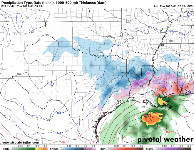
Big winter storm on 18z GFS.
6 likes
The above post and any post by Ntxw is NOT an official forecast and should not be used as such. It is just the opinion of the poster and may or may not be backed by sound meteorological data. It is NOT endorsed by any professional institution including Storm2k. For official information, please refer to NWS products.
Help support Storm2K!
Help support Storm2K!
-
Iceresistance

- Category 5
- Posts: 9565
- Age: 22
- Joined: Sat Oct 10, 2020 9:45 am
- Location: Tecumseh, OK/Norman, OK
Re: Texas Winter 2024-2025
Ntxw wrote:Big winter storm on 18z GFS.
And yet I get missed from both storms
EDIT: Of course I speak too soon!
Last edited by Iceresistance on Thu Jan 02, 2025 5:20 pm, edited 1 time in total.
2 likes
Bill 2015 & Beta 2020
Winter 2020-2021
All observations are in Tecumseh, OK unless otherwise noted.
Winter posts are focused mainly for Oklahoma & Texas.
Take any of my forecasts with a grain of salt, refer to the NWS, SPC, and NHC for official information
Never say Never with weather! Because ANYTHING is possible!
Winter 2020-2021
All observations are in Tecumseh, OK unless otherwise noted.
Winter posts are focused mainly for Oklahoma & Texas.
Take any of my forecasts with a grain of salt, refer to the NWS, SPC, and NHC for official information
Never say Never with weather! Because ANYTHING is possible!
-
Brandon8181
- S2K Supporter
- Posts: 431
- Age: 42
- Joined: Tue Jan 04, 2011 4:52 pm
- Location: Tyler, TX
- Contact:
Re: Texas Winter 2024-2025
HockeyTx82 wrote:Ntxw wrote:Can we all sit back and appreciate for a moment all this potential was out 300+ hours and is still a threat? That's a very long way out.
I think we should also take a moment for how many times we had people completely jump ship and lose it over every little model run, and yet here we are and it might still just happen, think about all that wasted emotion.
We always have to remember when its beyond 10 days...its generally about the "trend". Colder/Hotter/wetter, etc.... and then locations is very generalized at that point.
1 likes
I am not a meteorologist. Any post from me should be taken as hobby or fun educational information, but not an accurate source for weather information. Please, refer to your local weather station or National Weather Service for the most up to date information.
-
UTSARoadrunner4
- Category 1

- Posts: 264
- Age: 29
- Joined: Wed Aug 26, 2020 11:19 pm
Re: Texas Winter 2024-2025
[xpost] https://x.com/chrissuchanwoai/status/18 ... 7t10NsZo2Q[/xpost]
As of right now, at least 1 San Antonio meteorologist is starting to become “intrigued”…
As of right now, at least 1 San Antonio meteorologist is starting to become “intrigued”…
0 likes
-
Iceresistance
- Category 5
- Posts: 9565
- Age: 22
- Joined: Sat Oct 10, 2020 9:45 am
- Location: Tecumseh, OK/Norman, OK
Re: Texas Winter 2024-2025
3 likes
Bill 2015 & Beta 2020
Winter 2020-2021
All observations are in Tecumseh, OK unless otherwise noted.
Winter posts are focused mainly for Oklahoma & Texas.
Take any of my forecasts with a grain of salt, refer to the NWS, SPC, and NHC for official information
Never say Never with weather! Because ANYTHING is possible!
Winter 2020-2021
All observations are in Tecumseh, OK unless otherwise noted.
Winter posts are focused mainly for Oklahoma & Texas.
Take any of my forecasts with a grain of salt, refer to the NWS, SPC, and NHC for official information
Never say Never with weather! Because ANYTHING is possible!
-
Brandon8181
- S2K Supporter
- Posts: 431
- Age: 42
- Joined: Tue Jan 04, 2011 4:52 pm
- Location: Tyler, TX
- Contact:
Re: Texas Winter 2024-2025
Ntxw wrote:Big winter storm on 18z GFS.
You are under doing it. That one is freaking huge lol
3 likes
I am not a meteorologist. Any post from me should be taken as hobby or fun educational information, but not an accurate source for weather information. Please, refer to your local weather station or National Weather Service for the most up to date information.
-
bubba hotep

- S2K Supporter
- Posts: 6011
- Joined: Wed Dec 28, 2016 1:00 am
- Location: Collin County Texas
Re: Texas Winter 2024-2025
Oh good grief
0 likes
Winter time post are almost exclusively focused on the DFW area.
Re: Texas Winter 2024-2025
Brandon8181 wrote:Ntxw wrote:Big winter storm on 18z GFS.
You are under doing it. That one is freaking huge lol
Yeah it's a full neg tilt trough coming out. It's just one run.
2 likes
The above post and any post by Ntxw is NOT an official forecast and should not be used as such. It is just the opinion of the poster and may or may not be backed by sound meteorological data. It is NOT endorsed by any professional institution including Storm2k. For official information, please refer to NWS products.
Help support Storm2K!
Help support Storm2K!


-
Iceresistance
- Category 5
- Posts: 9565
- Age: 22
- Joined: Sat Oct 10, 2020 9:45 am
- Location: Tecumseh, OK/Norman, OK
Re: Texas Winter 2024-2025
4 likes
Bill 2015 & Beta 2020
Winter 2020-2021
All observations are in Tecumseh, OK unless otherwise noted.
Winter posts are focused mainly for Oklahoma & Texas.
Take any of my forecasts with a grain of salt, refer to the NWS, SPC, and NHC for official information
Never say Never with weather! Because ANYTHING is possible!
Winter 2020-2021
All observations are in Tecumseh, OK unless otherwise noted.
Winter posts are focused mainly for Oklahoma & Texas.
Take any of my forecasts with a grain of salt, refer to the NWS, SPC, and NHC for official information
Never say Never with weather! Because ANYTHING is possible!
Who is online
Users browsing this forum: No registered users and 191 guests