I'm not the only one remembering Irma.
https://twitter.com/pppapin/status/1420765493401726976
2021 Indicators: SST's / SAL / MSLP / Shear / Steering / Instability / Sat Images
Moderator: S2k Moderators
Forum rules

The posts in this forum are NOT official forecasts and should not be used as such. They are just the opinion of the poster and may or may not be backed by sound meteorological data. They are NOT endorsed by any professional institution or STORM2K. For official information, please refer to products from the National Hurricane Center and National Weather Service.
-
tolakram
- Admin

- Posts: 20186
- Age: 62
- Joined: Sun Aug 27, 2006 8:23 pm
- Location: Florence, KY (name is Mark)
Re: 2021 Indicators: SST's / SAL / MSLP / Shear / Steering / Instability / Sat Images
3 likes
M a r k
- - - - -
Join us in chat: Storm2K Chatroom Invite. Android and IOS apps also available.
The posts in this forum are NOT official forecasts and should not be used as such. Posts are NOT endorsed by any professional institution or STORM2K.org. For official information and forecasts, please refer to NHC and NWS products.

Re: 2021 Indicators: SST's / SAL / MSLP / Shear / Steering / Instability / Sat Images
tolakram wrote:Ouch.
2017 indicators thread, Aug 7th: http://www.storm2k.org/phpbb2/viewtopic.php?f=31&t=118642&start=1240
Irma was a cat 3 by Sept 1st.
This aged as well as a bowl of old milk sitting out in the Sun:
https://mobile.twitter.com/MJVentrice/s ... 4123187200
Harvey became a Cat 4 in the Gulf during the last week of August, Irma became a ridiculously high ACE major during the first week of September, and then Jose nearly became the first ever consecutive Atlantic Cat 5 in the following week. That’s quite the opposite of a shutdown lol
8 likes
Irene '11 Sandy '12 Hermine '16 5/15/2018 Derecho Fay '20 Isaias '20 Elsa '21 Henri '21 Ida '21
I am only a meteorology enthusiast who knows a decent amount about tropical cyclones. Look to the professional mets, the NHC, or your local weather office for the best information.
I am only a meteorology enthusiast who knows a decent amount about tropical cyclones. Look to the professional mets, the NHC, or your local weather office for the best information.
-
Category5Kaiju

- Category 5

- Posts: 4334
- Joined: Thu Dec 24, 2020 12:45 pm
- Location: Seattle and Phoenix
Re: 2021 Indicators: SST's / SAL / MSLP / Shear / Steering / Instability / Sat Images
aspen wrote:tolakram wrote:Ouch.
2017 indicators thread, Aug 7th: http://www.storm2k.org/phpbb2/viewtopic.php?f=31&t=118642&start=1240
Irma was a cat 3 by Sept 1st.
This aged as well as a bowl of old milk sitting out in the Sun:
https://mobile.twitter.com/MJVentrice/s ... 4123187200
Harvey became a Cat 4 in the Gulf during the last week of August, Irma became a ridiculously high ACE major during the first week of September, and then Jose nearly became the first ever consecutive Atlantic Cat 5 in the following week. That’s quite the opposite of a shutdown lol
Don't forget Maria, and then Nate, and then Ophelia. Almost seems like 2017 really got pissed off with all of those early August season cancel posts so it decided to go into explosive overdrive and generated 10 hurricanes straight.
1 likes
Unless explicitly stated, all info in my posts is based on my own opinions and observations. Tropical storms and hurricanes can be extremely dangerous. Refer to an accredited weather research agency or meteorologist if you need to make serious decisions regarding an approaching storm.
-
tolakram
- Admin
- Posts: 20186
- Age: 62
- Joined: Sun Aug 27, 2006 8:23 pm
- Location: Florence, KY (name is Mark)
Re: 2021 Indicators: SST's / SAL / MSLP / Shear / Steering / Instability / Sat Images
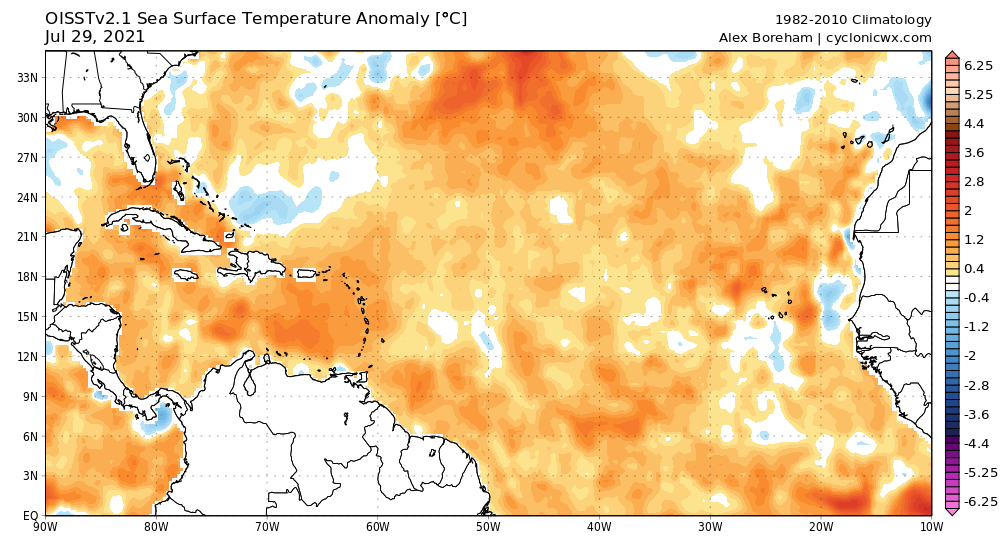
Current SST anomalies.

5 likes
M a r k
- - - - -
Join us in chat: Storm2K Chatroom Invite. Android and IOS apps also available.
The posts in this forum are NOT official forecasts and should not be used as such. Posts are NOT endorsed by any professional institution or STORM2K.org. For official information and forecasts, please refer to NHC and NWS products.
- - - - -
Join us in chat: Storm2K Chatroom Invite. Android and IOS apps also available.
The posts in this forum are NOT official forecasts and should not be used as such. Posts are NOT endorsed by any professional institution or STORM2K.org. For official information and forecasts, please refer to NHC and NWS products.
-
Category5Kaiju
- Category 5
- Posts: 4334
- Joined: Thu Dec 24, 2020 12:45 pm
- Location: Seattle and Phoenix
Re: 2021 Indicators: SST's / SAL / MSLP / Shear / Steering / Instability / Sat Images
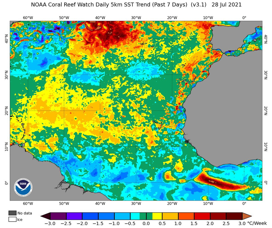
Atlantic seems to be warming up very nicely; I think this is the first time as of recently that there are very scant regions of blue (which have mainly disappeared and been replaced with white, if not yellow). You can also see the equatorial EPAC cooling off too with those "blue wave" patterns (not sure if there is a specific term for that, but that's what I personally call them).
Also, what the heck is going on with the Sea of Japan???
0 likes
Unless explicitly stated, all info in my posts is based on my own opinions and observations. Tropical storms and hurricanes can be extremely dangerous. Refer to an accredited weather research agency or meteorologist if you need to make serious decisions regarding an approaching storm.
-
ScottNAtlanta

- Category 5
- Posts: 2535
- Joined: Sat May 25, 2013 3:11 pm
- Location: Atlanta, GA
Re: 2021 Indicators: SST's / SAL / MSLP / Shear / Steering / Instability / Sat Images
There is a very fine line between a shearing TUTT and one that can ventilate a storm to allow it to bomb out. Irma is an excellent example of that. Many times you get a hurricane that alters the synoptic pattern to just push the shear out of the way...Laura did just that, Marco, neither being very large or intense didn't. Last year was a very good lesson on this type of pattern. We saw it happen several times. Predicted shear just got nudged far enough away to create excellent ventilation for some storms.
8 likes
The posts in this forum are NOT official forecast and should not be used as such. They are just the opinion of the poster and may or may not be backed by sound meteorological data. They are NOT endorsed by any professional institution or storm2k.org. For official information, please refer to the NHC and NWS products.
-
ScottNAtlanta
- Category 5
- Posts: 2535
- Joined: Sat May 25, 2013 3:11 pm
- Location: Atlanta, GA
Re: 2021 Indicators: SST's / SAL / MSLP / Shear / Steering / Instability / Sat Images
Category5Kaiju wrote:
Atlantic seems to be warming up very nicely; I think this is the first time as of recently that there are very scant regions of blue (which have mainly disappeared and been replaced with white, if not yellow). You can also see the equatorial EPAC cooling off too with those "blue wave" patterns (not sure if there is a specific term for that, but that's what I personally call them).
Also, what the heck is going on with the Sea of Japan???
Especially with all the rain and flooding all over the region of China that borders that area. Wouldn't that have a cooling effect?
Perhaps I need to go back to Geography 101 because the Red area borders Russia not China...the area off the Chinese coast is indeed cool...ooops
Last edited by ScottNAtlanta on Thu Jul 29, 2021 12:21 pm, edited 1 time in total.
0 likes
The posts in this forum are NOT official forecast and should not be used as such. They are just the opinion of the poster and may or may not be backed by sound meteorological data. They are NOT endorsed by any professional institution or storm2k.org. For official information, please refer to the NHC and NWS products.
-
AlphaToOmega
- Category 5
- Posts: 1448
- Joined: Sat Jun 26, 2021 10:51 am
- Location: Somewhere in Massachusetts
Re: 2021 Indicators: SST's / SAL / MSLP / Shear / Steering / Instability / Sat Images
Updated my spreadsheet to include data from 1967 to 2020
1 likes
-
Deshaunrob17
- Tropical Storm

- Posts: 211
- Joined: Tue Aug 18, 2020 7:49 am
Re: 2021 Indicators: SST's / SAL / MSLP / Shear / Steering / Instability / Sat Images
Category5Kaiju wrote:tolakram wrote:About this time last year. Different year, but still cancel season. Rather than call out anyone, just review what was being said and determine if anything stands out as maybe spotting an indicator, or didn't matter at all. There's nothing wrong with being wrong, but I would hope that we all can learn year to year what to look for, and maybe what to ignore. This single page doesn't have any smoking guns, but it does have the familiar angst that conditions aren't perfect.
http://www.storm2k.org/phpbb2/viewtopic.php?f=31&t=120763&start=1940
I'm also trying to find the chatter just before Irma came through. A very large TUTT was dominant in the Caribbean until it wasn't.
Wasn't personally lurking on this forum back then, but yeah, you are absolutely right. It does seem like there's a general occasional pattern of some hurricane enthusiasts getting nervous that conditions may not be as conducive as expected for the Atlantic when in reality such worries did not really pan out to be legitimate worries. In the end, 2020 saw 30 NSs and did become a hyperactive season, contrary to what some talks at least at the time of your posted link to the 2020 indicators thread mentioned.
Edit: Just went through your link to the 2017 season; I personally did not know people were canceling the season in August of 2017 to that level, wow. What an unexpected turn.
Ohh yes!! 2017 was my first year tracking, so I remember exactly how things went.. We had 2 MDR storms before August, which signaled active season ahead. After Bret formed, many started making comparisons to 2005 and expected July to produce a Dennis/ Emily like system. Never happened!! we only had Don and Emily which were weak and short lived. After Emily on August 1st, season cancelled posts was at it's peak. Many thought the season would be one for just weak and short-lived storms.
However, the parade of hurricanes started a week after Emily.
The rest is history q
1 likes
-
AutoPenalti
- Category 5
- Posts: 4091
- Age: 29
- Joined: Mon Aug 17, 2015 4:16 pm
- Location: Ft. Lauderdale, Florida
Re: 2021 Indicators: SST's / SAL / MSLP / Shear / Steering / Instability / Sat Images
tolakram wrote:Ouch.
2017 indicators thread, Aug 7th: http://www.storm2k.org/phpbb2/viewtopic.php?f=31&t=118642&start=1240
Irma was a cat 3 by Sept 1st.
To be fair, that initially started by a poster who is infamously known to say that.
1 likes
The posts in this forum are NOT official forecasts and should not be used as such. They are just the opinion of the poster and may or may not be backed by sound meteorological data. They are NOT endorsed by any professional institution or STORM2K. For official information, please refer to products from the NHC and NWS.
Model Runs Cheat Sheet:
GFS (5:30 AM/PM, 11:30 AM/PM)
HWRF, GFDL, UKMET, NAVGEM (6:30-8:00 AM/PM, 12:30-2:00 AM/PM)
ECMWF (1:45 AM/PM)
TCVN is a weighted averaged
-
SFLcane

- S2K Supporter

- Posts: 10281
- Age: 48
- Joined: Sat Jun 05, 2010 1:44 pm
- Location: Lake Worth Florida
Re: 2021 Indicators: SST's / SAL / MSLP / Shear / Steering / Instability / Sat Images
Now that’s what i call rapid warming. 
Last edited by SFLcane on Thu Jul 29, 2021 12:30 pm, edited 1 time in total.
6 likes
-
Category5Kaiju
- Category 5
- Posts: 4334
- Joined: Thu Dec 24, 2020 12:45 pm
- Location: Seattle and Phoenix
Re: 2021 Indicators: SST's / SAL / MSLP / Shear / Steering / Instability / Sat Images
I know I've joked about it before, but imho a season that is cancel-proof would literally have a June major hurricane and like three majors in July. It's unreasonable and highly unlikely, I know, but it almost seems like some people would only be convinced that a season will be active if powerful storms appear in the June-very early August months, when literally 99% of all seasons (I will discount 2005 for obvious reasons) in the recorded past did not feature anything close to this.
0 likes
Unless explicitly stated, all info in my posts is based on my own opinions and observations. Tropical storms and hurricanes can be extremely dangerous. Refer to an accredited weather research agency or meteorologist if you need to make serious decisions regarding an approaching storm.
-
SFLcane
- S2K Supporter
- Posts: 10281
- Age: 48
- Joined: Sat Jun 05, 2010 1:44 pm
- Location: Lake Worth Florida
Re: 2021 Indicators: SST's / SAL / MSLP / Shear / Steering / Instability / Sat Images
Looks like some of the Atlantic Nino warmth came north.
2 likes
-
Stormybajan

- Category 1

- Posts: 453
- Joined: Thu May 20, 2021 3:21 pm
- Location: Windward Islands
Re: 2021 Indicators: SST's / SAL / MSLP / Shear / Steering / Instability / Sat Images
Category5Kaiju wrote:
Atlantic seems to be warming up very nicely; I think this is the first time as of recently that there are very scant regions of blue (which have mainly disappeared and been replaced with white, if not yellow). You can also see the equatorial EPAC cooling off too with those "blue wave" patterns (not sure if there is a specific term for that, but that's what I personally call them).
Also, what the heck is going on with the Sea of Japan???
Think those are called Instability Waves
0 likes
Sad West Indies and Manchester United fan ⚽️
-
AnnularCane

- S2K Supporter
- Posts: 2962
- Joined: Thu Jun 08, 2006 9:18 am
- Location: Wytheville, VA
Re: 2021 Indicators: SST's / SAL / MSLP / Shear / Steering / Instability / Sat Images
tolakram wrote:Ouch.
2017 indicators thread, Aug 7th: http://www.storm2k.org/phpbb2/viewtopic.php?f=31&t=118642&start=1240
Irma was a cat 3 by Sept 1st.
I think the 2017 thread was brought out before, maybe a couple years ago? It's probably good that we still have that thread on hand for such purposes. I wouldn't be surprised if it were brought up again in future seasons.
Am I correct that the MJO phases are less influential on the tropics during the peak months (except maybe during El Niño years)?
1 likes
"But it never rained rain. It never snowed snow. And it never blew just wind. It rained things like soup and juice. It snowed mashed potatoes and green peas. And sometimes the wind blew in storms of hamburgers." -- Judi Barrett, Cloudy with a Chance of Meatballs
-
Category5Kaiju
- Category 5
- Posts: 4334
- Joined: Thu Dec 24, 2020 12:45 pm
- Location: Seattle and Phoenix
Re: 2021 Indicators: SST's / SAL / MSLP / Shear / Steering / Instability / Sat Images
Just for funsies, let me bring up this Tweet from the 2017 season right before it exploded into action. I think it also would apply quite well to this year as always.
https://twitter.com/webberweather/status/899427722367315968
https://twitter.com/webberweather/status/899427722367315968
9 likes
Unless explicitly stated, all info in my posts is based on my own opinions and observations. Tropical storms and hurricanes can be extremely dangerous. Refer to an accredited weather research agency or meteorologist if you need to make serious decisions regarding an approaching storm.
-
captainbarbossa19

- Professional-Met

- Posts: 1094
- Age: 27
- Joined: Wed Aug 21, 2019 11:09 pm
- Location: Beaumont, TX
Re: 2021 Indicators: SST's / SAL / MSLP / Shear / Steering / Instability / Sat Images
I think that part of what might be going on with these shear forecasts for August is that they are showing an average for the whole month. It is quite possible that shear could be higher than normal in the Caribbean for a large section of August. However, there is a good chance towards the middle and end of the month, conditions could rapidly change and become more favorable for development.
Also, another possibility is that the models are not handling the transition of the MJO very well. It really seems like models often have trouble with this and how it changes the overall environment of basins as it progresses.
Also, another possibility is that the models are not handling the transition of the MJO very well. It really seems like models often have trouble with this and how it changes the overall environment of basins as it progresses.
7 likes

Re: 2021 Indicators: SST's / SAL / MSLP / Shear / Steering / Instability / Sat Images
1 likes
Andy D
(For official information, please refer to the NHC and NWS products.)
(For official information, please refer to the NHC and NWS products.)
-
AlphaToOmega
- Category 5
- Posts: 1448
- Joined: Sat Jun 26, 2021 10:51 am
- Location: Somewhere in Massachusetts
Re: 2021 Indicators: SST's / SAL / MSLP / Shear / Steering / Instability / Sat Images
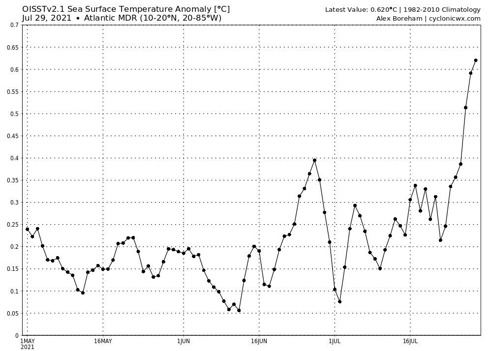
The MDR is 0.62 C above-average.
0 likes
Re: 2021 Indicators: SST's / SAL / MSLP / Shear / Steering / Instability / Sat Images
AlphaToOmega wrote:The MDR is 0.62 C above-average.
https://i.postimg.cc/X72Yj09y/ssta-graph-atlmdr.png
The OISST seems to have a warm bias. On the CRW map, it’s 0.24C above average. Both agree that the Gulf is roughly 0.55-0.65C warmer that normal, but are very different with the Caribbean: +0.81C (OISST) vs +0.39C (CRW). Regardless, everything is running warmer than average now.
The mean SSTs in the Gulf have risen to 30.01C. This combined with the extra-warm Loop Current really make me concerned about something going bonkers in the Gulf, if it’s given the optimal moisture and shear/UL setup.
6 likes
Irene '11 Sandy '12 Hermine '16 5/15/2018 Derecho Fay '20 Isaias '20 Elsa '21 Henri '21 Ida '21
I am only a meteorology enthusiast who knows a decent amount about tropical cyclones. Look to the professional mets, the NHC, or your local weather office for the best information.
I am only a meteorology enthusiast who knows a decent amount about tropical cyclones. Look to the professional mets, the NHC, or your local weather office for the best information.
Who is online
Users browsing this forum: WaveBreaking, wwizard and 251 guests