Texas Fall 2018

U.S. & Caribbean Weather Discussions and Severe Weather Events

Moderator: S2k Moderators

Forum rules

The posts in this forum are NOT official forecast and should not be used as such. They are just the opinion of the poster and may or may not be backed by sound meteorological data. They are NOT endorsed by any professional institution or STORM2K.

Help Support Storm2K
Message
Author
User avatar
Ntxw
Storm2k Moderator
Storm2k Moderator
Posts: 22784
Joined: Wed Oct 21, 2009 6:34 pm
Location: DFW, Texas

Re: Texas Fall 2018

#1921 Postby Ntxw » Wed Nov 21, 2018 9:27 am

rolldamntoad wrote:
Ntxw wrote:How much of that is terrain also? I would imagine that for somewhere like Atlanta or Birmingham, the cold air has to make it past the Ozarks and parts of the Smokies. Here, east of the Rockies, there's little but prairie for the cold air to pass over.


It's definitely all about terrain and geography. From the Northwest Canada to Texas is mostly downhill. While it is prairie and plains, the northern and central plains are higher than us. For example most of western Kansas is 2-3k feet up despite being flat. So if you can imagine the cold air just oozing slowly down a slope.
1 likes   
The above post and any post by Ntxw is NOT an official forecast and should not be used as such. It is just the opinion of the poster and may or may not be backed by sound meteorological data. It is NOT endorsed by any professional institution including Storm2k. For official information, please refer to NWS products.

  Help support Storm2K!
Help Support Storm2K

User avatar
bubba hotep
S2K Supporter
S2K Supporter
Posts: 5837
Joined: Wed Dec 28, 2016 1:00 am
Location: Collin County Texas

Re: Texas Fall 2018

#1922 Postby bubba hotep » Wed Nov 21, 2018 10:07 am

orangeblood wrote:
TeamPlayersBlue wrote:Did someone say, stepping down? Early December looks fun!


I'd say more like stepping up into the money phases of the MJO....which, btw, we should see a lot of this winter - amped up 8-1!!! :jacket:

http://www.cpc.ncep.noaa.gov/products/precip/CWlink/MJO/diagram_40days_forecast_GEFS_member.gif


The +ENSO MJO composites for Dec are not actually that cold looking, which isn't surprising given that Dec is traditionally a warmer month during +ENSO events. The Euro isn't as amped and is faster, a blend of the Euro and GFS probably gets you close to what we have been seeing out of the MJO.

Image

Both the Euro and GFS MJO forecast tend to favor a -NAO with the more amped up GFS tending to more strongly favor a -NAO.
0 likes   
Winter time post are almost exclusively focused on the DFW area.

User avatar
Ntxw
Storm2k Moderator
Storm2k Moderator
Posts: 22784
Joined: Wed Oct 21, 2009 6:34 pm
Location: DFW, Texas

Re: Texas Fall 2018

#1923 Postby Ntxw » Wed Nov 21, 2018 10:22 am

I'm going to make a quick counter argument to the December Nino climo. I made a composite of all +ENSO in the new ONI subset (minus 1963 and 2009 being extreme cold outliers) and the 500mb pattern below.

Note your typical +ENSO Decembers do not feature a -NAO, in fact the opposite. A strong Alaskan trough and +NAO is favored in that climo. This December is likely to feature a negative NAO and AO unlike those years.

Image
Here are the two very cold 1963 and 2009 Decembers.

Image

So in conclusion, with the albeit small sample size, a -NAO/-AO in December during an El Nino is not very common.
3 likes   
The above post and any post by Ntxw is NOT an official forecast and should not be used as such. It is just the opinion of the poster and may or may not be backed by sound meteorological data. It is NOT endorsed by any professional institution including Storm2k. For official information, please refer to NWS products.


  Help support Storm2K!

Help Support Storm2K


orangeblood
S2K Supporter
S2K Supporter
Posts: 3714
Joined: Tue Dec 15, 2009 6:14 pm
Location: Fort Worth, TX

Re: Texas Fall 2018

#1924 Postby orangeblood » Wed Nov 21, 2018 10:31 am

bubba hotep wrote:
orangeblood wrote:
TeamPlayersBlue wrote:Did someone say, stepping down? Early December looks fun!


I'd say more like stepping up into the money phases of the MJO....which, btw, we should see a lot of this winter - amped up 8-1!!! :jacket:

http://www.cpc.ncep.noaa.gov/products/precip/CWlink/MJO/diagram_40days_forecast_GEFS_member.gif


The +ENSO MJO composites for Dec are not actually that cold looking, which isn't surprising given that Dec is traditionally a warmer month during +ENSO events. The Euro isn't as amped and is faster, a blend of the Euro and GFS probably gets you close to what we have been seeing out of the MJO.


Both the Euro and GFS MJO forecast tend to favor a -NAO with the more amped up GFS tending to more strongly favor a -NAO.


But I've noticed lately, the Euro MJO forecasts have often been too fast and dampened...GEFS has led the way!!
1 likes   

rwfromkansas
Category 5
Category 5
Posts: 2627
Joined: Sat Aug 27, 2005 12:47 am
Location: North Fort Worth

Re: Texas Fall 2018

#1925 Postby rwfromkansas » Wed Nov 21, 2018 10:35 am

Cpv17 wrote:
Ntxw wrote:
Cpv17 wrote:This is a very good looking trough to give us at least a good shot at some rain is it not? Does it need to dig more? You would think there would be a lot of precipitation over us with this setup.

https://www.tropicaltidbits.com/analysis/models/gfs/2018112018/gfs_z500a_us_41.png


It's a decent trough, but on this run it is diving southeast from the mountain west in a positive tilt before rounding the base. The jet is split ahead east of us. To get a good soaker we need something to dig down California and into NW Mexico and really pump up Pacific moisture.


I understand what you’re saying now. And also I went and Googled some climo maps of precipitation after what you said about the climo being much wetter east of us. Yeah it’s no comparison. Living about 100 miles west of 35 seems pretty boring.

https://d32ogoqmya1dw8.cloudfront.net/images/eslabs/weather/us_ppt_1971-2000_456.png


I lived in the area of darker orange for six years. So friggin dry.

The only good thing? More ice and snow on average than here since the cold goes south faster, but still not often...I was too far south in Midland. If I was in Lubbock it would have been better.

I like it in DFW since I grew up in KS with roughly the same rainfall and climate, aside from the average 20 inches of snow and more winter cold.
0 likes   

rwfromkansas
Category 5
Category 5
Posts: 2627
Joined: Sat Aug 27, 2005 12:47 am
Location: North Fort Worth

Re: Texas Fall 2018

#1926 Postby rwfromkansas » Wed Nov 21, 2018 10:41 am

Ntxw wrote:
rolldamntoad wrote:
Ntxw wrote:How much of that is terrain also? I would imagine that for somewhere like Atlanta or Birmingham, the cold air has to make it past the Ozarks and parts of the Smokies. Here, east of the Rockies, there's little but prairie for the cold air to pass over.


It's definitely all about terrain and geography. From the Northwest Canada to Texas is mostly downhill. While it is prairie and plains, the northern and central plains are higher than us. For example most of western Kansas is 2-3k feet up despite being flat. So if you can imagine the cold air just oozing slowly down a slope.


You don’t need a 540 thickness in higher areas for snow either. IIRC when I lived in Midland 536-38 or so would do it often.
0 likes   

User avatar
bubba hotep
S2K Supporter
S2K Supporter
Posts: 5837
Joined: Wed Dec 28, 2016 1:00 am
Location: Collin County Texas

Re: Texas Fall 2018

#1927 Postby bubba hotep » Wed Nov 21, 2018 10:43 am

Ntxw wrote:DFW had another low deep in the 30s this morning at 34. While 30s may seem insignificant that is running -10F below the normal lows and we have been doing it on a consistent basis adding to the monthly departure. And for the past 12 days only 2 nights were close to normal and above 40, the rest were below 40. That's an amazing feat given urban heat island!


The avgs for this time of year at DFW are 65/44 and the 00z Euro EPS only shows 2 days that are avg or above avg over the next two weeks. This has been a solid cold snap since things flipped in mid-October.
2 likes   
Winter time post are almost exclusively focused on the DFW area.

User avatar
Ntxw
Storm2k Moderator
Storm2k Moderator
Posts: 22784
Joined: Wed Oct 21, 2009 6:34 pm
Location: DFW, Texas

Re: Texas Fall 2018

#1928 Postby Ntxw » Wed Nov 21, 2018 10:53 am

Jamstec seasonal forecast for winter (November's data) is out and it is the coldest forecast it's had for DJF since 2009 for the US. It's been decent. It had one fatal flaw year being 2015 and went overly with Nino climo, but that was a Super event and can be forgiven anomaly.

Image
2 likes   
The above post and any post by Ntxw is NOT an official forecast and should not be used as such. It is just the opinion of the poster and may or may not be backed by sound meteorological data. It is NOT endorsed by any professional institution including Storm2k. For official information, please refer to NWS products.


  Help support Storm2K!

Help Support Storm2K


User avatar
South Texas Storms
Professional-Met
Professional-Met
Posts: 4226
Joined: Thu Jun 24, 2010 12:28 am
Location: Houston, TX

Re: Texas Fall 2018

#1929 Postby South Texas Storms » Wed Nov 21, 2018 10:58 am

:uarrow:
Yep I was just discussing that with my long range coworker. We looked at the 500mb height anomalies, and it's textbook for cold across much of the country. The model shows consistent major blocking across northern Canada and the North Pole this winter.
3 likes   

hamburgerman7070
Category 1
Category 1
Posts: 253
Joined: Sat Dec 02, 2017 7:39 pm
Location: Jonesboro ar

Re: Texas Fall 2018

#1930 Postby hamburgerman7070 » Wed Nov 21, 2018 10:58 am

Ntxw, would you agree that the pattern may support more ice and sleet over snow if we see a winter storm later on? Sw flow over cold air. I guess isentropic lift? I thought I saw the gefs going into phase 1 pretty strong with mjo beginning of December
0 likes   

User avatar
Ntxw
Storm2k Moderator
Storm2k Moderator
Posts: 22784
Joined: Wed Oct 21, 2009 6:34 pm
Location: DFW, Texas

Re: Texas Fall 2018

#1931 Postby Ntxw » Wed Nov 21, 2018 11:00 am

hamburgerman7070 wrote:Ntxw, would you agree that the pattern may support more ice and sleet over snow if we see a winter storm later on? Sw flow over cold air. I guess isentropic lift? I thought I saw the gefs going into phase 1 pretty strong with mjo beginning of December


I'd make the argument it favors snow over sleet and ice. It's going to be all or nothing type winter rain to snow. 500mb heights are below normal across the south-central and southeastern US meaning air is colder up above than usual. It's the same reason storms are amplifying vs shearing out in a higher 500mb height regime. We may see several events this winter where above is colder and the surface is barely scratching 32-34F.
3 likes   
The above post and any post by Ntxw is NOT an official forecast and should not be used as such. It is just the opinion of the poster and may or may not be backed by sound meteorological data. It is NOT endorsed by any professional institution including Storm2k. For official information, please refer to NWS products.


  Help support Storm2K!

Help Support Storm2K


User avatar
Haris
Category 5
Category 5
Posts: 1810
Joined: Mon Nov 27, 2017 8:19 pm
Location: ( Bee Cave) West Austin, Texas

Re: Texas Fall 2018

#1932 Postby Haris » Wed Nov 21, 2018 11:14 am

Image

This is quite cool!
1 likes   
Weather geek and a storm spotter in West Austin. Not a degreed meteorologist. Big snow fan. Love rain and cold! Despise heat!

User avatar
bubba hotep
S2K Supporter
S2K Supporter
Posts: 5837
Joined: Wed Dec 28, 2016 1:00 am
Location: Collin County Texas

Re: Texas Fall 2018

#1933 Postby bubba hotep » Wed Nov 21, 2018 11:32 am

Ntxw wrote:I'm going to make a quick counter argument to the December Nino climo. I made a composite of all +ENSO in the new ONI subset (minus 1963 and 2009 being extreme cold outliers) and the 500mb pattern below.

Note your typical +ENSO Decembers do not feature a -NAO, in fact the opposite. A strong Alaskan trough and +NAO is favored in that climo. This December is likely to feature a negative NAO and AO unlike those years.

https://images2.imgbox.com/92/d1/UheMj5AG_o.jpg
Here are the two very cold 1963 and 2009 Decembers.

https://images2.imgbox.com/0e/40/Bv79w2Fv_o.jpg

So in conclusion, with the albeit small sample size, a -NAO/-AO in December during an El Nino is not very common.


'63 and '09 both ended up West based but they both had cold anomalies in the NE Pacific. The warm anomalies in the NE Pacific this year resemble '14 and it looks like '18 will continue to be West based +ENSO. There are no early winter SSW events in the ESRL data set for '63 or '09 but '09 saw increased 100mb poleward heat flux, similar to what we have seen so far in '18.
0 likes   
Winter time post are almost exclusively focused on the DFW area.

User avatar
bubba hotep
S2K Supporter
S2K Supporter
Posts: 5837
Joined: Wed Dec 28, 2016 1:00 am
Location: Collin County Texas

Re: Texas Fall 2018

#1934 Postby bubba hotep » Wed Nov 21, 2018 11:36 am

Looks like we are headed for 100 pages in the Fall thread! :)
4 likes   
Winter time post are almost exclusively focused on the DFW area.

User avatar
Ntxw
Storm2k Moderator
Storm2k Moderator
Posts: 22784
Joined: Wed Oct 21, 2009 6:34 pm
Location: DFW, Texas

Re: Texas Fall 2018

#1935 Postby Ntxw » Wed Nov 21, 2018 11:48 am

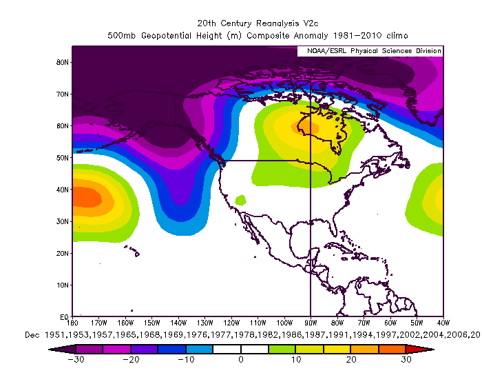
bubba hotep wrote:'63 and '09 both ended up West based but they both had cold anomalies in the NE Pacific. The warm anomalies in the NE Pacific this year resemble '14 and it looks like '18 will continue to be West based +ENSO. There are no early winter SSW events in the ESRL data set for '63 or '09 but '09 saw increased 100mb poleward heat flux, similar to what we have seen so far in '18.


2014 is a poor solar match though being maximum and the +PDO was very extreme. 2014 is also basically an early start to the bigger continuous Nino of 2015 and 2016, it was a very ++NAO winter overall. Really it was the Pacific that saved that winter late.

Image

PDO values from JISAO, it is warmer but not at 2014 levels.

Code: Select all

2009**  -1.40  -1.55  -1.59  -1.65  -0.88  -0.31  -0.53   0.09   0.52   0.27  -0.40   0.08
2010**   0.83   0.82   0.44   0.78   0.62  -0.22  -1.05  -1.27  -1.61  -1.06  -0.82  -1.21
2011**  -0.92  -0.83  -0.69  -0.42  -0.37  -0.69  -1.86  -1.74  -1.79  -1.34  -2.33  -1.79
2012**  -1.38  -0.85  -1.05  -0.27  -1.26  -0.87  -1.52  -1.93  -2.21  -0.79  -0.59  -0.48
2013**  -0.13  -0.43  -0.63  -0.16   0.08  -0.78  -1.25  -1.04  -0.48  -0.87  -0.11  -0.41
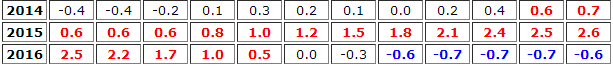
2014**   0.30   0.38   0.97   1.13   1.80   0.82   0.70   0.67   1.08   1.49   1.72   2.51
2015**   2.45   2.30   2.00   1.44   1.20   1.54   1.84   1.56   1.94   1.47   0.86   1.01
2016**   1.53   1.75   2.40   2.62   2.35   2.03   1.25   0.52   0.45   0.56   1.88   1.17
2017**   0.77   0.70   0.74   1.12   0.88   0.79   0.10   0.09   0.32   0.05   0.15   0.50
2018**   0.70   0.37  -0.05   0.11   0.11  -0.04   0.11   0.18   0.09


Another little tid bit is that the Atlantic hurricane season is very busy this year, unusual for any El Nino. 1963 fits that bill most with similar ACE as this year. I've always believed the multiyear NAO tends to follow the fluxes of the solar cycles. We have a tendency to hit +NAO during maximum and -NAO during minimums. It's not a 1:1 correlation but I'll have to dig for papers that suggest such.
2 likes   
The above post and any post by Ntxw is NOT an official forecast and should not be used as such. It is just the opinion of the poster and may or may not be backed by sound meteorological data. It is NOT endorsed by any professional institution including Storm2k. For official information, please refer to NWS products.


  Help support Storm2K!

Help Support Storm2K


DonWrk
Category 1
Category 1
Posts: 488
Age: 37
Joined: Mon Jan 03, 2011 11:54 pm
Location: Collinsville, TX

Re: Texas Fall 2018

#1936 Postby DonWrk » Wed Nov 21, 2018 12:02 pm

Hope this doesn’t make y’all jealous! On the honeymoon in Steamboat Springs balcony view!

(hope the image isn’t too massive in the post, was having heck trying to upload and post on my mobile)

Image
6 likes   

User avatar
South Texas Storms
Professional-Met
Professional-Met
Posts: 4226
Joined: Thu Jun 24, 2010 12:28 am
Location: Houston, TX

Re: Texas Fall 2018

#1937 Postby South Texas Storms » Wed Nov 21, 2018 1:37 pm

The end of the 12z FV3-GFS shows a classic TX snowstorm developing. Cold air is in place across the state with a deep low pressure system approaching from Mexico.

The 12z GFS looks nothing like it. :lol:
3 likes   

User avatar
cheezyWXguy
Category 5
Category 5
Posts: 6108
Joined: Mon Feb 13, 2006 12:29 am
Location: Dallas, TX

Re: Texas Fall 2018

#1938 Postby cheezyWXguy » Wed Nov 21, 2018 2:11 pm

South Texas Storms wrote:The end of the 12z FV3-GFS shows a classic TX snowstorm developing. Cold air is in place across the state with a deep low pressure system approaching from Mexico.

The 12z GFS looks nothing like it. :lol:

lol and neither does the 6z FV3

EDIT: the last 3 runs of the regular GFS do seem to show western trough pattern showing up in the long range though.
2 likes   

User avatar
bubba hotep
S2K Supporter
S2K Supporter
Posts: 5837
Joined: Wed Dec 28, 2016 1:00 am
Location: Collin County Texas

Re: Texas Fall 2018

#1939 Postby bubba hotep » Wed Nov 21, 2018 3:26 pm

Maybe the first significant system for Texas in a while? The last few runs of the Euro have been digging a system into the SW with decent opportunity for moisture return across Texas before the system kicks out across the state.

Image
2 likes   
Winter time post are almost exclusively focused on the DFW area.

User avatar
TeamPlayersBlue
Category 5
Category 5
Posts: 3445
Joined: Tue Feb 02, 2010 1:44 am
Location: Denver/Applewood, CO

Re: Texas Fall 2018

#1940 Postby TeamPlayersBlue » Wed Nov 21, 2018 4:49 pm

I know -EPO is great for arctic blasts, but how is the -PNA/-AO combo for us? Would that be promising? As said above, a trough digging west of texas that tracks across the state would be the best orientation for moisture.
0 likes   
Personal Forecast Disclaimer:
The posts in this forum are NOT official forecast and should not be used as such. They are just the opinion of the poster and may or may not be backed by sound meteorological data. They are NOT endorsed by any professional institution or storm2k.org. For official information, please refer to the NHC and NWS products.


Return to “USA & Caribbean Weather”

Who is online

Users browsing this forum: No registered users and 10 guests