NATL: MELISSA - Aftermath - Discussion: Josh Morgerman video of Melissa is up

Moderator: S2k Moderators

Message
Author
User avatar
Hurricane2022
Category 5
Category 5
Posts: 1957
Joined: Tue Aug 23, 2022 11:38 pm
Location: Araçatuba, Brazil

Re: NATL: MELISSA - Hurricane - Discussion

#1941 Postby Hurricane2022 » Mon Oct 27, 2025 9:50 pm

cycloneye wrote:
InfernoFlameCat wrote:When is the next plane?


4 AM NOAA.

From cyclonicwx:
Depart time: 28/0800Z (5 hours and 15 minutes from now)

Entry time: 28/1000Z

Fix time: 28/1200Z


This plane will depart from Meli at 0530z, so we still have two more penetrations, if the aircraft remains well.
Last edited by Hurricane2022 on Mon Oct 27, 2025 9:51 pm, edited 1 time in total.
1 likes   
Sorry for the bad English sometimes...!
For reliable and detailed information for any meteorological phenomenon, please consult the National Hurricane Center, Joint Typhoon Warning Center , or your local Meteo Center.

--------

ECCE OMNIA NOVA FACIAM (Ap 21,5).

Keldeo1997
Category 2
Category 2
Posts: 688
Joined: Fri Oct 11, 2019 11:35 pm

Re: NATL: MELISSA - Hurricane - Discussion

#1942 Postby Keldeo1997 » Mon Oct 27, 2025 9:51 pm

Image

Image

Hmm there is no Double wind max
Last edited by Keldeo1997 on Mon Oct 27, 2025 9:51 pm, edited 1 time in total.
4 likes   

User avatar
Teban54
Category 5
Category 5
Posts: 3787
Joined: Sat May 19, 2018 1:19 pm

Re: NATL: MELISSA - Hurricane - Discussion

#1943 Postby Teban54 » Mon Oct 27, 2025 9:51 pm

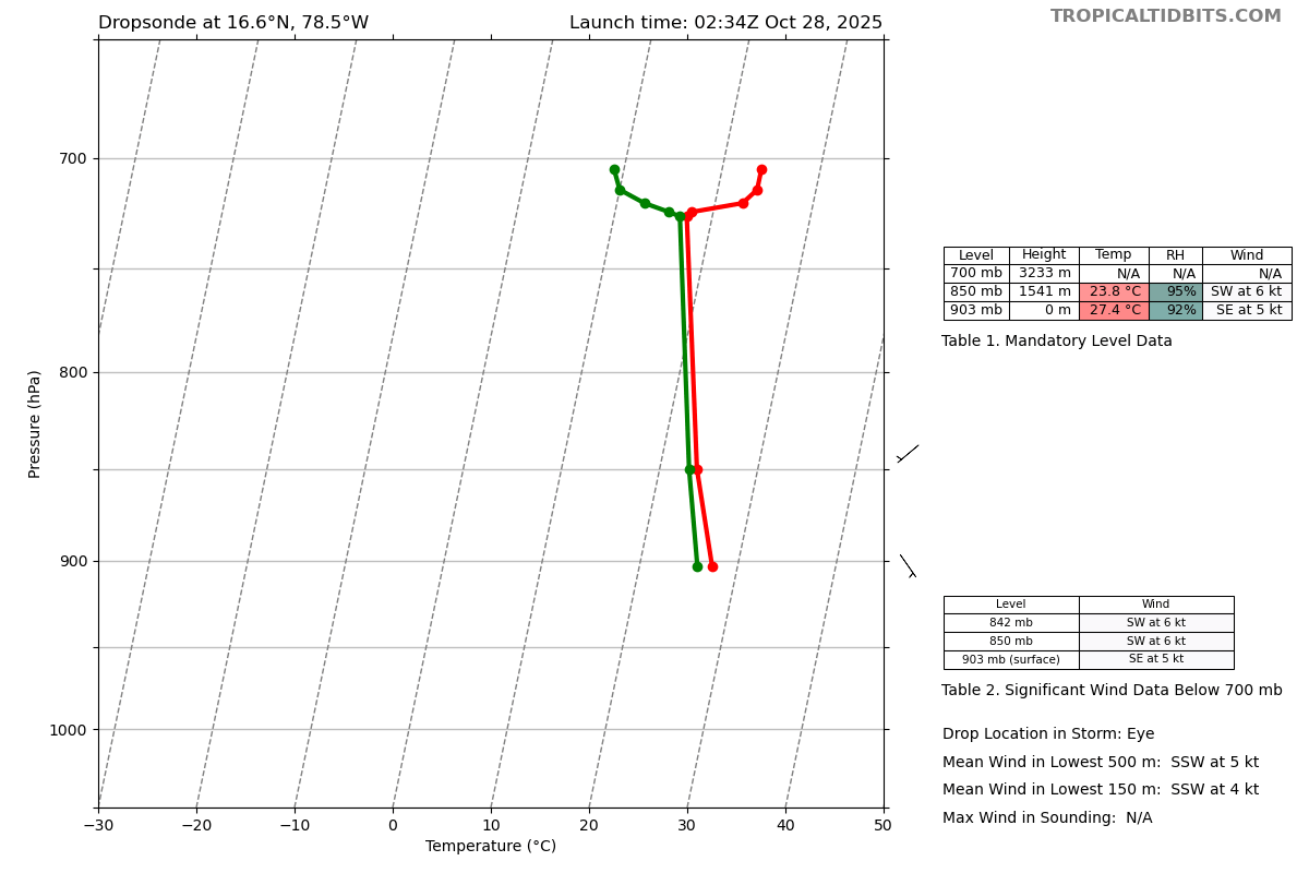
Here's the eye drop:

Image
0 likes   

Fancy1002
Category 1
Category 1
Posts: 322
Joined: Sun Dec 25, 2022 3:47 pm

Re: NATL: MELISSA - Hurricane - Discussion

#1944 Postby Fancy1002 » Mon Oct 27, 2025 9:51 pm

zzzh wrote:
972
UZNT13 KNHC 280247
XXAA 78038 99166 70785 04468 99903 27415 14505 00/// ///// /////
92/// ///// ///// 85541 23808 22006 70233 ///// 88999 77999
31313 09608 80234
61616 AF301 2213A MELISSA OB 22
62626 CENTER MBL WND 20505 AEV 40002 DLM WND 21005 903842 WL150 2
0504 080 REL 1660N07854W 023616 SPG 1660N07854W 023706 =
XXBB 78038 99166 70785 04468 00903 27415 11850 23808 22726 17407
33724 17823 44720 22860 55714 24064 66705 24065
21212 00903 14505 11850 22006 22842 23006
31313 09608 80234
61616 AF301 2213A MELISSA OB 22
62626 CENTER MBL WND 20505 AEV 40002 DLM WND 21005 903842 WL150 2
0504 080 REL 1660N07854W 023616 SPG 1660N07854W 023706 =
;

dropsonde 903mb

It seems like it broke and didn’t reach the surface.
1 likes   

User avatar
Hypercane_Kyle
Category 5
Category 5
Posts: 3465
Joined: Sat Mar 07, 2015 7:58 pm
Location: Cape Canaveral, FL

Re: NATL: MELISSA - Hurricane - Discussion

#1945 Postby Hypercane_Kyle » Mon Oct 27, 2025 9:52 pm

I'd go with 180mph, 902mb based on that last pass and dropsonde data.
11 likes   
My posts are my own personal opinion, defer to the National Hurricane Center (NHC) and other NOAA products for decision making during hurricane season.

wx98
Category 5
Category 5
Posts: 1396
Joined: Sat Aug 25, 2018 9:24 pm

Re: NATL: MELISSA - Hurricane - Discussion

#1946 Postby wx98 » Mon Oct 27, 2025 9:53 pm

Teban54 wrote:
Travorum wrote:
Teban54 wrote:Keep in mind that this AF plane's extrap pressure on the last pass was too low: it was extrapolating 903 mb, when two dropsonades from different aircraft confirmed 907 mb.

So hold your breath once you see the pressure, until the dropsonade confirms it.


Or the AF plane could just not broadcast extrap pressure and we can wait for the dropsonde apparently.

:lol: :lol: :lol:

Anyway, NE quad has 162 kt FL, similar to SW. Some other recent passes also had surprisingly high FL winds in the SW quad as well.


The system is barely moving, so, theoretically, winds should be similar in all quads with lack of forward motion.
3 likes   

User avatar
Jr0d
S2K Supporter
S2K Supporter
Posts: 1471
Joined: Tue Aug 27, 2019 10:52 am
Location: Cayo Hueso

Re: NATL: MELISSA - Hurricane - Discussion

#1947 Postby Jr0d » Mon Oct 27, 2025 9:53 pm

Teban54 wrote:
cycloneye wrote:
InfernoFlameCat wrote:When is the next plane?


4 AM NOAA.

The current AF plane has an exit time of 0530z (1:30 am EDT) for a 6-hour-long mission, so it should do a few more passes (if I understood it correctly).


If so, I hope they can get their surface pressure data back online. Also I am sure the crew and plane have taken a beating so making the full 6 hours will be one hell of an accomplishment for the crew, the plane and those maintaining the WC-130s.
4 likes   

CrazyC83
Professional-Met
Professional-Met
Posts: 34308
Joined: Tue Mar 07, 2006 11:57 pm
Location: Deep South, for the first time!

Re: NATL: MELISSA - Hurricane - Discussion

#1948 Postby CrazyC83 » Mon Oct 27, 2025 9:54 pm

Welcome to the Top 10, Melissa.

That reading would place it at either a tie for 8th or sole possession of 9th all-time.
13 likes   

User avatar
ScottNAtlanta
Category 5
Category 5
Posts: 2535
Joined: Sat May 25, 2013 3:11 pm
Location: Atlanta, GA

Re: NATL: MELISSA - Hurricane - Discussion

#1949 Postby ScottNAtlanta » Mon Oct 27, 2025 9:54 pm

lol...time to start hitting refresh on the NHC site
9 likes   
The posts in this forum are NOT official forecast and should not be used as such. They are just the opinion of the poster and may or may not be backed by sound meteorological data. They are NOT endorsed by any professional institution or storm2k.org. For official information, please refer to the NHC and NWS products.

dukeblue219
S2K Supporter
S2K Supporter
Posts: 556
Joined: Fri Sep 30, 2016 3:52 pm

Re: NATL: MELISSA - Hurricane - Discussion

#1950 Postby dukeblue219 » Mon Oct 27, 2025 9:54 pm

Fancy1002 wrote:
It seems like it broke and didn’t reach the surface.

Based on?
0 likes   

User avatar
abajan
S2K Supporter
S2K Supporter
Posts: 4305
Age: 61
Joined: Sun Sep 07, 2003 5:10 am
Location: Barbados

Re: NATL: MELISSA - Hurricane - Discussion

#1951 Postby abajan » Mon Oct 27, 2025 9:57 pm

Preparations for Melissa in Jamaica earlier today:


Link: https://youtu.be/NSV8Lx20fH8

My apologies if this has already been shared but with almost 100 pages of comments, duplicate content can easily be missed.
2 likes   

User avatar
Hurricane2022
Category 5
Category 5
Posts: 1957
Joined: Tue Aug 23, 2022 11:38 pm
Location: Araçatuba, Brazil

Re: NATL: MELISSA - Hurricane - Discussion

#1952 Postby Hurricane2022 » Mon Oct 27, 2025 9:57 pm

NHC 150 903
0 likes   
Sorry for the bad English sometimes...!
For reliable and detailed information for any meteorological phenomenon, please consult the National Hurricane Center, Joint Typhoon Warning Center , or your local Meteo Center.

--------

ECCE OMNIA NOVA FACIAM (Ap 21,5).

CrazyC83
Professional-Met
Professional-Met
Posts: 34308
Joined: Tue Mar 07, 2006 11:57 pm
Location: Deep South, for the first time!

Re: NATL: MELISSA - Hurricane - Discussion

#1953 Postby CrazyC83 » Mon Oct 27, 2025 9:58 pm

The top 10 most intense storms now:

1) Wilma - 882
2) Gilbert - 888
3) 1935 Labor Day - 892
4) Milton - 895
4) Rita - 895
6) Allen - 899
7) Camille - 900
8) Katrina - 902
9) Melissa - 903
10) Dean - 905
10) Mitch - 905
9 likes   

User avatar
Travorum
Category 2
Category 2
Posts: 623
Joined: Tue Sep 05, 2023 9:36 am
Location: Dunedin, FL

Re: NATL: MELISSA - Hurricane - Discussion

#1954 Postby Travorum » Mon Oct 27, 2025 9:58 pm

150kts/903mb at 11pm, Melissa is #9 of all time by intensity
2 likes   

User avatar
Teban54
Category 5
Category 5
Posts: 3787
Joined: Sat May 19, 2018 1:19 pm

Re: NATL: MELISSA - Hurricane - Discussion

#1955 Postby Teban54 » Mon Oct 27, 2025 9:59 pm

CrazyC83 wrote:The top 10 most intense storms now:

1) Wilma - 882
2) Gilbert - 888
3) 1935 Labor Day - 892
4) Milton - 895
4) Rita - 895
6) Allen - 899
7) Camille - 900
8) Katrina - 902
9) Melissa - 903
10) Dean - 905
10) Mitch - 905

We're at the point where, if the current trend continues, every recon pass can shake off one or a few more storms from the list.
7 likes   

User avatar
Category5Kaiju
Category 5
Category 5
Posts: 4305
Joined: Thu Dec 24, 2020 12:45 pm
Location: Seattle and Phoenix

Re: NATL: MELISSA - Hurricane - Discussion

#1956 Postby Category5Kaiju » Mon Oct 27, 2025 9:59 pm

There's a very real possibility that Melissa's minimum core pressure will be lower than Mitch's and Dean's; the significant of this is that future Atlantic hurricanes would need to have a core pressure of LESS THAN 905 MBAR to even crack the top 10 most intense in history.

And, assuming we continue to get storms like Dorian, Milton, or Melissa in future seasons, then I do believe there will come a point when the top 10 most intense Atlantic hurricane list will solely consist of sub-900 members.

Edit: confirmed.
Last edited by Category5Kaiju on Mon Oct 27, 2025 10:00 pm, edited 1 time in total.
6 likes   
Unless explicitly stated, all info in my posts is based on my own opinions and observations. Tropical storms and hurricanes can be extremely dangerous. Refer to an accredited weather research agency or meteorologist if you need to make serious decisions regarding an approaching storm.

User avatar
aspen
Category 5
Category 5
Posts: 9042
Joined: Sat Oct 12, 2019 7:10 pm
Location: Connecticut, USA

Re: NATL: MELISSA - Hurricane - Discussion

#1957 Postby aspen » Mon Oct 27, 2025 9:59 pm

Odd eyewall drop. Winds drop from 140 kt to 122 kt right above the surface, then pick up to 160+ kt by the 919mb level.
0 likes   
Irene '11 Sandy '12 Hermine '16 5/15/2018 Derecho Fay '20 Isaias '20 Elsa '21 Henri '21 Ida '21

I am only a meteorology enthusiast who knows a decent amount about tropical cyclones. Look to the professional mets, the NHC, or your local weather office for the best information.

User avatar
zal0phus
Tropical Storm
Tropical Storm
Posts: 200
Age: 25
Joined: Mon Jan 07, 2019 8:32 am
Location: St. Louis
Contact:

Re: NATL: MELISSA - Hurricane - Discussion

#1958 Postby zal0phus » Mon Oct 27, 2025 10:00 pm

Another top-ten hurricane. What a terrible yet astounding two years it's been
4 likes   
Do not take anything I say seriously as a form of meteorological prediction. I am not a meteorologist; I don't think being in law school translates to any special knowledge. I am just a somewhat bullish amateur watcher.

User avatar
Teban54
Category 5
Category 5
Posts: 3787
Joined: Sat May 19, 2018 1:19 pm

Re: NATL: MELISSA - Hurricane - Discussion

#1959 Postby Teban54 » Mon Oct 27, 2025 10:01 pm

NHC no longer forecasts any weakening before landfall, and has 150 kt for the next forecast point. (I believe that the "inland" and "over water" were labeled on the wrong lines.)

FORECAST POSITIONS AND MAX WINDS

INIT 28/0300Z 16.6N 78.5W 150 KT 175 MPH
12H 28/1200Z 17.5N 78.3W 150 KT 175 MPH

24H 29/0000Z 18.8N 77.4W 120 KT 140 MPH
36H 29/1200Z 20.7N 76.0W 90 KT 105 MPH...INLAND
48H 30/0000Z 23.0N 74.3W 85 KT 100 MPH...OVER WATER
60H 30/1200Z 25.8N 72.0W 80 KT 90 MPH
72H 31/0000Z 29.8N 68.2W 75 KT 85 MPH
96H 01/0000Z 38.9N 56.5W 60 KT 70 MPH
120H 02/0000Z 47.5N 40.0W 50 KT 60 MPH...POST-TROP/EXTRATROP

$$
Forecaster Pasch
5 likes   

User avatar
xtyphooncyclonex
Category 5
Category 5
Posts: 3889
Age: 24
Joined: Sat Dec 08, 2012 9:07 am
Location: Cebu City
Contact:

Re: NATL: MELISSA - Hurricane - Discussion

#1960 Postby xtyphooncyclonex » Mon Oct 27, 2025 10:02 pm

CrazyC83 wrote:The top 10 most intense storms now:

1) Wilma - 882
2) Gilbert - 888
3) 1935 Labor Day - 892
4) Milton - 895
4) Rita - 895
6) Allen - 899
7) Camille - 900
8) Katrina - 902
9) Melissa - 903
10) Dean - 905
10) Mitch - 905


Crazy how we have two "M" storms from two years in a row making the list. Guess the M curse is a thing
6 likes   
REMINDER: My opinions that I, or any other NON Pro-Met in this forum, are unofficial. Please do not take my opinions as an official forecast and warning. I am NOT a meteorologist. Following my forecasts blindly may lead to false alarm, danger and risk if official forecasts from agencies are ignored.


Return to “2025”

Who is online

Users browsing this forum: No registered users and 29 guests