I can't see it going subtropical or tropical, but while rare, it is certainly not impossible...
It would be quite something for me to travel down there for the first time - in April of all months - and have a tropical storm sitting right next to me...
CMC Develops a Sub-Tropical(?) Low by Thursday
Moderator: S2k Moderators
Forum rules

The posts in this forum are NOT official forecasts and should not be used as such. They are just the opinion of the poster and may or may not be backed by sound meteorological data. They are NOT endorsed by any professional institution or STORM2K. For official information, please refer to products from the National Hurricane Center and National Weather Service.

Re: CMC Develops a Sub-Tropical(?) Low by Thursday
Duddy wrote:So at what point do each of you guys start to take the CMC seriously?
1. The day Wxman57 says "this time the CMC is absolutely right."
2. Whenever it shows a major hitting here. Unfortunately it does that all the time. Still it's hard to ignore animations of Cat 3-4-5s hitting South Florida. Even if you know "it's just a movie," it's still scary.
0 likes
-
Category 5

- Category 5

- Posts: 10074
- Age: 36
- Joined: Sun Feb 11, 2007 10:00 pm
- Location: New Brunswick, NJ
- Contact:
Re: CMC Develops a Sub-Tropical(?) Low by Thursday
Duddy wrote:So at what point do each of you guys start to take the CMC seriously?
When Cyclone1 learns how to type.
Seriously though, the CMC couldn't predict YESTERDAY'S weather.
0 likes
-
Tampa Bay Hurricane

- Category 5
- Posts: 5597
- Age: 38
- Joined: Fri Jul 22, 2005 7:54 pm
- Location: St. Petersburg, FL
Re: CMC Develops a Sub-Tropical(?) Low by Thursday
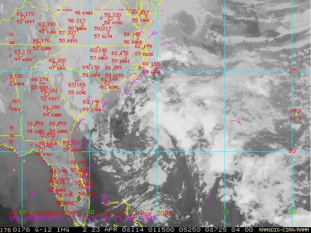
There is a very interesting spin. It is the upper level low moving
down from the Carolinas. It is probably an upper level low with a
potent circulation. It looks fascinating. Perhaps if it gets south
over warm water it would have a shot, but right now it is over
cold water.
down from the Carolinas. It is probably an upper level low with a
potent circulation. It looks fascinating. Perhaps if it gets south
over warm water it would have a shot, but right now it is over
cold water.
0 likes
-
Ed Mahmoud
Re: CMC Develops a Sub-Tropical(?) Low by Thursday
Tampa Bay Hurricane wrote:There is a very interesting spin. It is the upper level low moving
down from the Carolinas. It is probably an upper level low with a
potent circulation. It looks fascinating. Perhaps if it gets south
over warm water it would have a shot, but right now it is over
cold water.
It has something of a surface circulation, judging from the visible loop, but it doesn't look tropical or even sub-tropical.
0 likes

-
Meso

- Category 5
- Posts: 1609
- Age: 39
- Joined: Mon Aug 09, 2004 12:14 pm
- Location: South Africa
- Contact:
Yeah,the models show the one on the right slipping NE through a gap in the ridge and strengthening as it moves out and the one of the left is the one the CMC showed getting trapped by the high and staying fairly south.While it will be a rainy and windy area,that's likely about all,it appears...Soon though.. soon
0 likes


-
HURAKAN

- Professional-Met

- Posts: 46084
- Age: 39
- Joined: Thu May 20, 2004 4:34 pm
- Location: Key West, FL
- Contact:
Re:
KWT wrote:Hmm it does look a little like Andrea with that pop-corn like convection around the low but still doesn't look subtropical in nature yet anyway!
Yep. The pop-corn convection and the location just says Andrea. Nothing about subtropical development yet. We will have to see how long it stays over the Gulf Stream and how bad shear gets to be.
0 likes


Re: CMC Develops a Sub-Tropical(?) Low by Thursday
Andrea was the coolest looking STS I had ever seen. It would be cool if this developed a bit more.
0 likes
-
JonathanBelles
- Professional-Met
- Posts: 11430
- Age: 35
- Joined: Sat Dec 24, 2005 9:00 pm
- Location: School: Florida State University (Tallahassee, FL) Home: St. Petersburg, Florida
- Contact:
-
tolakram
- Admin

- Posts: 20186
- Age: 62
- Joined: Sun Aug 27, 2006 8:23 pm
- Location: Florence, KY (name is Mark)
Re: CMC Develops a Sub-Tropical(?) Low by Thursday
This low passed right over Cincinnati on it's round about path to the coast. So if it does develop, and I doubt it will, I'm going to claim I was in it. 
0 likes
-
Ed Mahmoud
Re: CMC Develops a Sub-Tropical(?) Low by Thursday
tolakram wrote:This low passed right over Cincinnati on it's round about path to the coast. So if it does develop, and I doubt it will, I'm going to claim I was in it.
I was living in LFT in 1997, and I was in the MCS that eventually became Hurricane Danny. That was quite a lightning producer.
0 likes

-
Tampa Bay Hurricane
- Category 5
- Posts: 5597
- Age: 38
- Joined: Fri Jul 22, 2005 7:54 pm
- Location: St. Petersburg, FL
Re: CMC Develops a Sub-Tropical(?) Low by Thursday
It looks much better this evening on the satellite shot (the north carolina
low). The Bahamas Low looks very nice as well and appears to have a circulation.
However, both circulations seem to be mid to upper level to my untrained eye.
It is interesting to watch, but nothing quite tropical yet.
Newest shot- looking a bit less healthy with the decrease in convection.
COULD we have 2 subtropical systems forming??
0 likes
-
Tampa Bay Hurricane
- Category 5
- Posts: 5597
- Age: 38
- Joined: Fri Jul 22, 2005 7:54 pm
- Location: St. Petersburg, FL
Who is online
Users browsing this forum: WaveBreaking and 264 guests