ARABIAN SEA - DEEP DEPRESSION (03A)

Moderator: S2k Moderators

Message
Author
User avatar
salmon123
Tropical Storm
Tropical Storm
Posts: 100
Age: 44
Joined: Mon Apr 28, 2008 1:56 pm
Location: karachi pakistan
Contact:

Re: Arabian Sea - Invest 94A

#21 Postby salmon123 » Mon May 31, 2010 3:00 am

WTIO21 PGTW 310730
MSGID/GENADMIN/NAVMARFCSTCEN PEARL HARBOR HI/JTWC//
SUBJ/TROPICAL CYCLONE FORMATION ALERT//
RMKS/
1. FORMATION OF A SIGNIFICANT TROPICAL CYCLONE IS POSSIBLE WITHIN
105 NM EITHER SIDE OF A LINE FROM 17.3N 64.6E TO 14.1N 64.3E
WITHIN THE NEXT 12 TO 24 HOURS. AVAILABLE DATA DOES NOT JUSTIFY
ISSUANCE OF NUMBERED TROPICAL CYCLONE WARNINGS AT THIS TIME.
WINDS IN THE AREA ARE ESTIMATED TO BE 25 TO 30 KNOTS. METSAT IM-
AGERY AND SYNOPTIC DATA AT 310600Z INDICATE THAT A CIRCULATION
CENTER IS LOCATED NEAR 14.9N 64.1E. THE SYSTEM IS MOVING NORTH-
NORTHWESTWARD AT 04 KNOTS.
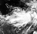
2. REMARKS: THE AREA OF CONVECTION PREVIOUSLY LOCATED NEAR 14.4N
64.2E, IS NOW LOCATED NEAR 14.9N 64.1E, APPROXIMATELY 545 NM WEST-
SOUTHWEST OF MUMBAI, INDIA. ANIMATED MULTISPECTRAL AND INFRARED
SATELLITE IMAGERY SHOW CONTINUED CONSOLIDATION OF THE LOW LEVEL
CIRCULATION CENTER (LLCC) WITH INCREASED DEEP CONVECTION BUILDING IN
THE VICINITY OF THE LLCC. UPPER LEVEL ANALYSIS INDICATES AN ANTI-
CYCLONE LOCATED OVER THE NORTHERN ARABIAN SEA IS PROVIDING FAVORABLE
EQUATORWARD OUTFLOW AND CREATING A MODERATE VERTICAL WIND SHEAR ENVI-
RONMENT FOR THE LLCC. SURFACE CONDITIONS ARE FAVORABLE WITH SEA SUR-
FACE TEMPERATURES AROUND 31 CELSIUS BASED ON RECENT BUOY AND SHIP
OBSERVATIONS. MAXIMUM SUSTAINED SURFACE WINDS ARE ESTIMATED AT 25 TO
30 KNOTS. THIS IS SUPPORTED BY A 310507Z ASCAT SCATTEROMETRY IMAGE
AND A SHIP OBSERVATION JUST TO THE WEST OF THE LLCC. MINIMUM SEA
LEVEL PRESSURE IS ESTIMATED TO BE NEAR 1005 MB. BASED ON BUILDING
DEEP CONVECTION AND FAVORABLE SURFACE CONDITIONS, THE POTENTIAL FOR
THE DEVELOPMENT OF A SIGNIFICANT TROPICAL CYCLONE WITHIN THE NEXT 24
HOURS IS UPGRADED TO GOOD.
3. THIS ALERT WILL BE REISSUED, UPGRADED TO WARNING OR CANCELED BY
010730Z.//
NNNN

Image
0 likes   

User avatar
Chacor
Category 5
Category 5
Posts: 10229
Joined: Mon Oct 02, 2006 10:43 pm
Location: Singapore

#22 Postby Chacor » Mon May 31, 2010 3:28 am

IMD: A LOW PRESSURE AREA LIES OVER EASTCENTRAL AND ADJOINING WESTCENTRAL ARABIAN SEA. ACCORDING TO INSAT IMAGERY, THE ASSOCIATED VORTEX T1.0 IS CENTRED NEAR LAT. 14.7°N LONG. 64.5°E. NUMERICAL WEATHER PREDICTION MODELS AND CURRENT METEOROLOGICAL CONDITIONS SUGGEST THAT THE LOW WOULD CONCENTRATE INTO A DEPRESSION DURING NEXT 24 HOURS.
0 likes   

User avatar
Crostorm
Category 5
Category 5
Posts: 2060
Age: 50
Joined: Mon Dec 25, 2006 3:51 pm
Location: Croatia-Europe
Contact:

Re: Arabian Sea - Invest 94A

#23 Postby Crostorm » Mon May 31, 2010 3:42 am

30 kts

Image
0 likes   

ugaap
Tropical Depression
Tropical Depression
Posts: 72
Joined: Tue Apr 29, 2008 3:10 am
Location: India
Contact:

Re: Arabian Sea - Invest 94A

#24 Postby ugaap » Mon May 31, 2010 6:22 am

ARB 02/2010/01 Dated: 31.05.2010

Time of issue: 1330 hours IST


Sub: Depression over eastcentral and adjoining westcentral Arabian Sea


Latest satellite imageries and surface observations indicate that a depression has formed over eastcentral and adjoining westcentral Arabian Sea and lay centred at 1130 hrs IST of today, the 31st May 2010 near latitude 15.00N and 64.00E, about 1050 km southwest of Mumbai, 1050 km south-southwest of Naliya and 1200 km south-southwest of Karachi.

The current environmental condition and numerical weather prediction (NWP) models suggest that the system would intensify gradually into a cyclonic storm and move initially in a northwesterly direction for next 48 hours and then recurve northeastwards towards Gujarat and adjoining Pakistan coast.

Under the influence of this system, fairly widespread rainfall with isolated heavy to very heavy falls would commence over coastal areas of Gujarat from 3rd June 2010. Squally winds with speed reaching 45-55 kmph would commence along and off Gujarat coast from 2nd June 2010.

Sea condition will be rough to very rough along and off Gujarat coast from 2nd June 2010. Fishermen are advised not venture into the sea during that period.

The system is under constant watch and concerned state Govts are being informed accordingly.

Next bulletin will be issued at 2030 hrs IST of 31ST May 2010.
0 likes   

ugaap
Tropical Depression
Tropical Depression
Posts: 72
Joined: Tue Apr 29, 2008 3:10 am
Location: India
Contact:

Re: Arabian Sea - Invest 94A

#25 Postby ugaap » Mon May 31, 2010 6:31 am

RSMC New Delhi

Tropical weather outlook for north Indian ocean (The bay of Bengal and Arabian sea) valid for next 24 hours issued at 0900 utc OF 31 May, 2010 based on 0600 UTC of 31 may, 2010 (.)


LATEST SATELLITE IMAGERY INDICATES THAT A DEPRESSION HAS FORMED OVER EAST CENTRAL AND ADJOINING WEST CENTRAL ARABIAN SEA AND LAY CENTRED AT 0600 UTC OF TODAY, THE 31ST MAY 2010 NEAR LAT. 15.00 N AND LONG. 64.00 E, ABOUT 1050 KM SOUTHWEST OF MUMBAI, 1050 KM SOUTH-SOUTHWEST OF NALIYA AND 1200 KM SOUTH-SOUTHWEST OF KARACHI.

SUSTAINED MAXIMUM SURFACE WIND SPEED IS ESTIMATED TO BE ABOUT 25 KNOTS. WINDS ARE STRONGER OVER THE SOUTHERN PART UNDER THE INFLUENCE OF THE MONSOON SURGE. THE STATE OF THE SEA IS ROUGH TO VERY ROUGH AROUND THE SYSTEM CENTRE. THE ESTIMATED CENTRAL PRESSURE IS ABOUT 1001 HPA.

SATELLITE IMAGERY INDICATES GRADUAL ORGANISATION OF CONVECTION DURING PAST TWELVE HOURS. THE INTENSITY OF THE SYSTEM IS T1.5. ASSOCIATED BROKEN INTENSE TO VERY INTENSE CONVECTION OBSERVED OVER AREA BETWEEN LAT. 10.00 N TO 18.00 N AND LONG. 57.00 TO 67.00 E. THE LOWEST CLOUD TOP TEMPERATURE (CTT) DUE TO CONVECTION IS AROUND -750C IN ASSOCIATION WITH THE SYSTEM.

VERTICAL WIND SHEAR OF HORIZONTAL WIND OVER THE REGION IS LOW TO MODERATE (10-20 KNOTS). THE SYSTEM LIES TO THE SOUTH OF TROPOSPHERIC RIDGE, WHICH ROUGHLY RUNS ALONG 170N. SEA SURFACE TEMPERATURE IS ALSO FAVOURABLE FOR INTENSIFICATION AS IT IS 300-320 C OVER THE REGION. THE DEPTH OF 26 DEG C SOTHERM IS MORE THAN 100 M OVER THE REGION. THE OCEAN HEAT CONTENT AS A RESULT IS MORE THAN 100 KJ/CM2 OVER THE REGION. THE RELATIVE VORTICITY AT 850 HPA LEVEL AND UPPER LEVEL DIVERGENCE ARE ALSO FAVOURABLE FOR INTENSIFICATION, AS THEY HAVE INCREASED DURING PAST 12 HRS. THERE IS AN UPPER AIR ANTI-CYCLONIC CIRCULATION TO THE NORTH OF THE SYSTEM, WHICH IS HELPING IN PROVIDING THE UPPER LEVEL DIVERGENCE AND POLEWARD OUTFLOW.

THE MJO IS EXPECTED TO BE IN INDIAN OCEAN DURING THIS WEEK, BUT WITH LOWER AMPLITUDE (<1), ACCORDING TO BOTH STATISTICAL AND DYNAMICAL FORECASTS. IT IS FAVOURABLE FOR INTENSIFICATION OF THE SYSTEM

THOUGH THE SYSTEM WOULD MOVE NORTHWESTWARDS INITIALLY, THE RECURVATURE IS EXPECTED AFTER 48 HRS UNDER THE INFLUENCE OF THE APPROACHING TROUGH IN MID-LATITUDE WESTERLIES AT 500 HPA LEVEL.

CONSIDERING ALL THE ABOVE AND NUMERICAL WEATHER PREDICTION (NWP) MODELS GUIDANCE, THE SYSTEM IS LIKELY TO INTENSIFY GRADUALLY INTO A CYCLONIC STORM AND MOVE INITIALLY IN A NORTHWESTERLY DIRECTION DURING NEXT 48 HRS AND THEN RECURVE NORTHEASTWARDS TOWARDS GUJARAT AND ADJOINING PAKISTAN COAST.
0 likes   

harith
Tropical Low
Tropical Low
Posts: 23
Joined: Mon May 31, 2010 8:00 am

Re: Arabian Sea - Invest 94A

#26 Postby harith » Mon May 31, 2010 8:15 am

Hello

I am from the Sultanate of Oman

A question for the experts
Will it affect the hurricane on the Sultanate of Oman??

Because it is very close to us

And you said that you will move towards the northwest for 48 hours

Please respond
0 likes   

User avatar
Iune
Category 1
Category 1
Posts: 291
Joined: Mon Aug 04, 2008 12:23 pm
Location: New York City

Re: Arabian Sea - Invest 94A

#27 Postby Iune » Mon May 31, 2010 8:36 am

harith wrote:Hello

I am from the Sultanate of Oman

A question for the experts
Will it affect the hurricane on the Sultanate of Oman??

Because it is very close to us

And you said that you will move towards the northwest for 48 hours

Please respond

It is currently predicted to move towards Gujarat/Pakistan but there is always a chance it might affect Oman.
0 likes   
Floyd 1999 · Irene 2011 · Sandy 2012

harith
Tropical Low
Tropical Low
Posts: 23
Joined: Mon May 31, 2010 8:00 am

Re: Arabian Sea - Invest 94A

#28 Postby harith » Mon May 31, 2010 8:47 am

Phoenix's Song wrote:
harith wrote:Hello

I am from the Sultanate of Oman

A question for the experts
Will it affect the hurricane on the Sultanate of Oman??

Because it is very close to us

And you said that you will move towards the northwest for 48 hours

Please respond

It is currently predicted to move towards Gujarat/Pakistan but there is always a chance it might affect Oman.


Thank you for your reply
:
But there is a decrease in the values of surface pressure in Amman
:
Which is lower than the values of the pressure on Jwaijerat
0 likes   

soul2006
Tropical Wave
Tropical Wave
Posts: 8
Age: 41
Joined: Mon May 31, 2010 9:01 am

Re: Arabian Sea - Invest 94A

#29 Postby soul2006 » Mon May 31, 2010 9:05 am

hi all

this way will move until now
Image
0 likes   

harith
Tropical Low
Tropical Low
Posts: 23
Joined: Mon May 31, 2010 8:00 am

Re: Arabian Sea - Invest 94A

#30 Postby harith » Mon May 31, 2010 9:16 am

Latest photos of the hurricane Artificial


Image

Uploaded with ImageShack.us
0 likes   

harith
Tropical Low
Tropical Low
Posts: 23
Joined: Mon May 31, 2010 8:00 am

Re: Arabian Sea - Invest 94A

#31 Postby harith » Mon May 31, 2010 9:19 am

Another low-orbital coordinates deep Arabian Sea

.94 A.INVEST.30kts.1000mb.14.9N.63.6E

Tropical Depression based on the latitude 14.9 north and longitude 63.6 east
And speed 30 knots, and pressure dropped to 1000 millibars

The last movement for the center of the depression was only towards the West
0 likes   

harith
Tropical Low
Tropical Low
Posts: 23
Joined: Mon May 31, 2010 8:00 am

Re: Arabian Sea - Invest 94A

#32 Postby harith » Mon May 31, 2010 9:31 am

A statement from the Department of tent Weather: Report No. (1): I still forecasting numerical Oman in particular, and according to the World likely to develop low-current air Arabian Sea to a tropical storm during the next 48 hours with movement Batiih somewhat to the north far from the coast of the Sultanate of progression of the situation to the point hurricane-depth morning of 2 June or before that misrepresents the situation to the north-east strongly to Pakistan and parts of India, north-west and is expected to rain, floods devastating the impact of tropical cyclone and we hope to take meteorological Allbeckestanip, Hindi warnings pre-emptive all over Pakistan, especially the coast before the deviation Aliztrab Orbital expected, God willing According to the consensus of local and global forecasts and point at the same time that expectations do not refer to the impact on the Sultanate of this situation which was far other than sporadic entry of significant amounts of clouds on the southeastern coast and a potential may give some quick and unexpected splashes rough sea waves are advised not to ride in the sea
0 likes   

User avatar
cycloneye
Admin
Admin
Posts: 143871
Age: 68
Joined: Thu Oct 10, 2002 10:54 am
Location: San Juan, Puerto Rico

Re: Arabian Sea - Invest 94A

#33 Postby cycloneye » Mon May 31, 2010 9:35 am

Welcome to Storm2k to the new members.
0 likes   
Visit the Caribbean-Central America Weather Thread where you can find at first post web cams,radars
and observations from Caribbean basin members Click Here

harith
Tropical Low
Tropical Low
Posts: 23
Joined: Mon May 31, 2010 8:00 am

Re: Arabian Sea - Invest 94A

#34 Postby harith » Mon May 31, 2010 9:50 am

Path of the hurricane, which made so far


Image

Uploaded with ImageShack.us
0 likes   

ugaap
Tropical Depression
Tropical Depression
Posts: 72
Joined: Tue Apr 29, 2008 3:10 am
Location: India
Contact:

Re: Arabian Sea - Invest 94A

#35 Postby ugaap » Mon May 31, 2010 10:01 am

IMD New Dlhi
ARB 02/2010/02 Dated: 31.05.2010

Time of issue: 1930 hours IST


Sub: Depression over eastcentral and adjoining westcentral Arabian Sea


Latest satellite imageries and surface observations indicate that a depression has formed over eastcentral and adjoining westcentral Arabian Sea moved northwestward and lay centred at 1730 hrs IST of today, the 31st May 2010 near latitude 15.50N and 63.50E, about 1050 km southwest of Mumbai, 1050 km south-southwest of Naliya and 1200 km south-southwest of Karachi.

The current environmental condition and numerical weather prediction (NWP) models suggest that the system would intensify gradually into a cyclonic storm and continue to move initially in a northwesterly direction for next 48 hours and then recurve northeastwards towards Gujarat and adjoining Pakistan coast.

Under the influence of this system, fairly widespread rainfall with isolated heavy to very heavy falls would commence over coastal areas of Gujarat from 3rd June 2010. Squally winds with speed reaching 45-55 kmph would commence along and off Gujarat coast from 2nd June 2010.

Sea condition will be rough to very rough along and off Gujarat coast from 2nd June 2010. Fishermen are advised not to venture into the sea during that period.

Next bulletin will be issued at 0230 hrs IST of 01st June 2010.
0 likes   

harith
Tropical Low
Tropical Low
Posts: 23
Joined: Mon May 31, 2010 8:00 am

Re: Arabian Sea - Invest 94A

#36 Postby harith » Mon May 31, 2010 10:06 am

For the case of known and the pattern of the situation consists in the beginning of June and the hurricane would be a wali to the third grade during the day and reel up and become a hurricane after it turns into a storm and development in such a case is very fast and rapidly
0 likes   

harith
Tropical Low
Tropical Low
Posts: 23
Joined: Mon May 31, 2010 8:00 am

Re: Arabian Sea - Invest 94A

#37 Postby harith » Mon May 31, 2010 10:11 am

Warming the Arabian Sea to this day


Image

Uploaded with ImageShack.us
0 likes   

soul2006
Tropical Wave
Tropical Wave
Posts: 8
Age: 41
Joined: Mon May 31, 2010 9:01 am

Re: Arabian Sea - Invest 94A

#38 Postby soul2006 » Mon May 31, 2010 10:15 am

harith wrote:Warming the Arabian Sea to this day


Image

Uploaded with ImageShack.us


hi harith
i'm from oman - in al battinah

thank you my brother for warm map
0 likes   

ugaap
Tropical Depression
Tropical Depression
Posts: 72
Joined: Tue Apr 29, 2008 3:10 am
Location: India
Contact:

Re: Arabian Sea - Invest 94A

#39 Postby ugaap » Mon May 31, 2010 10:21 am

SPECIAL TROPICAL WEATHER OUTLOOK

DEMS–RSMC TROPICAL CYCLONES NEW DELHI 31-05-2010


Tropical weather outlook for north Indian ocean (The bay of Bengal and Arabian sea) valid for next 24 hours issued at 1500 utc OF 31 May, 2010 based on 1200 UTC of 31 may, 2010 (.)


THE DEPRESSION OVER EAST CENTRAL AND ADJOINING WEST CENTRAL ARABIAN SEA MOVED NORTHWESTWARDS AND LAY CENTRED AT 1200 UTC OF TODAY, THE 31ST MAY 2010 OVER WESTCENTRAL AND ADJOINING EASTCENTRAL ARABIAN SEA NEAR LAT. 15.50 N AND LONG. 63.50 E, ABOUT 1050 KM SOUTHWEST OF MUMBAI, 1050 KM SOUTH-SOUTHWEST OF NALIYA (GUJARAT) AND 1120 KM SOUTH-SOUTHWEST OF KARACHI.

SUSTAINED MAXIMUM SURFACE WIND SPEED IS ESTIMATED TO BE ABOUT 25 KNOTS. WINDS ARE STRONGER OVER THE SOUTHERN PART UNDER THE INFLUENCE OF THE MONSOON SURGE. THE STATE OF THE SEA IS ROUGH TO VERY ROUGH AROUND THE SYSTEM CENTRE. THE ESTIMATED CENTRAL PRESSURE IS ABOUT 1001 HPA.

SATELLITE IMAGERY INDICATES GRADUAL ORGANISATION OF CONVECTION DURING PAST TWELVE HOURS. THE INTENSITY OF THE SYSTEM IS T1.5. ASSOCIATED BROKEN INTENSE TO VERY INTENSE CONVECTION OBSERVED OVER AREA BETWEEN LAT. 10.00 N TO 17.00 N AND LONG. 56.50 TO 67.00 E. THE LOWEST CLOUD TOP TEMPERATURE (CTT) DUE TO CONVECTION IS AROUND -750C IN ASSOCIATION WITH THE SYSTEM.

VERTICAL WIND SHEAR OF HORIZONTAL WIND OVER THE REGION IS LOW TO MODERATE (10-20 KNOTS). THE SYSTEM LIES TO THE SOUTH OF TROPOSPHERIC RIDGE, WHICH ROUGHLY RUNS ALONG 170N. SEA SURFACE TEMPERATURE (300-320 C), DEPTH OF 26 DEG C ISOTHERM ( MORE THAN 100 M) AND THE OCEAN HEAT CONTENT (MORE THAN 100 KJ/CM2 OVER THE REGION ARE FAVOURABLE FOR INTENSIFICATION. THE RELATIVE VORTICITY AT 850 HPA LEVEL AND UPPER LEVEL DIVERGENCE ARE ALSO FAVOURABLE FOR INTENSIFICATION, AS THEY HAVE INCREASED DURING PAST 12 HRS.

THE SYSTEM WOULD CONTINUE TO MOVE NORTHWESTWARDS FOR SOME MORE TIME AND THE RECURVATURE IS EXPECTED AFTER 48 HRS UNDER THE INFLUENCE OF THE APPROACHING TROUGH IN MID-LATITUDE WESTERLIES AT 500 HPA LEVEL.

CONSIDERING ALL THE ABOVE AND NUMERICAL WEATHER PREDICTION (NWP) MODELS GUIDANCE, THE SYSTEM IS LIKELY TO INTENSIFY GRADUALLY INTO A CYCLONIC STORM AND MOVE INITIALLY IN A NORTHWESTERLY DIRECTION DURING NEXT 48 HRS AND THEN RECURVE NORTHEASTWARDS TOWARDS GUJARAT AND ADJOINING PAKISTAN COAST.
0 likes   

harith
Tropical Low
Tropical Low
Posts: 23
Joined: Mon May 31, 2010 8:00 am

Re: Arabian Sea - Invest 94A

#40 Postby harith » Mon May 31, 2010 10:22 am

.....
Last edited by harith on Mon May 31, 2010 10:59 am, edited 1 time in total.
0 likes   


Return to “2010”

Who is online

Users browsing this forum: No registered users and 56 guests