My numbers won't change though, I think this season will be a lot like the 2009 year.
2012 WPAC season
Moderator: S2k Moderators
Forum rules
The posts in this forum are NOT official forecasts and should not be used as such. They are just the opinion of the poster and may or may not be backed by sound meteorological data. They are NOT endorsed by any professional institution or STORM2K. For official information, please refer to products from the National Hurricane Center and National Weather Service.
-
dexterlabio
- Category 5

- Posts: 3499
- Joined: Sat Oct 24, 2009 11:50 pm
Re: 2012 WPAC season
Ohhhh I see.......I just didn't feel the La Nina going on then until 2011.....well things just got more exciting, still I am unsure if WPAC season this year will be busier than last year. I also read somewhere in this forum that there's something going on, not just the Nino, that is affecting the Pacific.
My numbers won't change though, I think this season will be a lot like the 2009 year.
My numbers won't change though, I think this season will be a lot like the 2009 year.
0 likes
Personal Forecast Disclaimer:
The posts in this forum are NOT official forecast and should not be used as such. They are just the opinion of the poster and may or may not be backed by sound meteorological data. They are NOT endorsed by any professional institution or storm2k.org. For official information, please refer to the NHC and NWS products.
The posts in this forum are NOT official forecast and should not be used as such. They are just the opinion of the poster and may or may not be backed by sound meteorological data. They are NOT endorsed by any professional institution or storm2k.org. For official information, please refer to the NHC and NWS products.
- cycloneye
- Admin

- Posts: 148730
- Age: 69
- Joined: Thu Oct 10, 2002 10:54 am
- Location: San Juan, Puerto Rico
Re: 2012 WPAC season
The basin is turning a little bit active with a couple of new invests. Let's see if any of them goes ahead and develop into a TD or more (Meaning the name Pakhar) or they stay as invests.
0 likes
Visit the Caribbean-Central America Weather Thread where you can find at first post web cams,radars
and observations from Caribbean basin members Click Here
and observations from Caribbean basin members Click Here
- cycloneye
- Admin

- Posts: 148730
- Age: 69
- Joined: Thu Oct 10, 2002 10:54 am
- Location: San Juan, Puerto Rico
Re: 2012 WPAC season
The Euro shows something forming by the 30th-31rst in the South China Sea.


0 likes
Visit the Caribbean-Central America Weather Thread where you can find at first post web cams,radars
and observations from Caribbean basin members Click Here
and observations from Caribbean basin members Click Here
- cycloneye
- Admin

- Posts: 148730
- Age: 69
- Joined: Thu Oct 10, 2002 10:54 am
- Location: San Juan, Puerto Rico
Re: 2012 WPAC season
The Euro is not alone with the South China Sea development as GFS is also in the developing camp. But GFS has another system south of Guam in ten days.


0 likes
Visit the Caribbean-Central America Weather Thread where you can find at first post web cams,radars
and observations from Caribbean basin members Click Here
and observations from Caribbean basin members Click Here
-
euro6208
Re: 2012 WPAC season


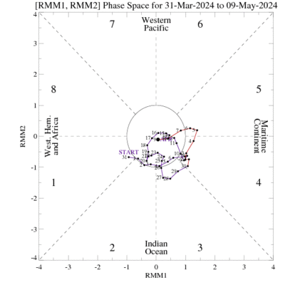
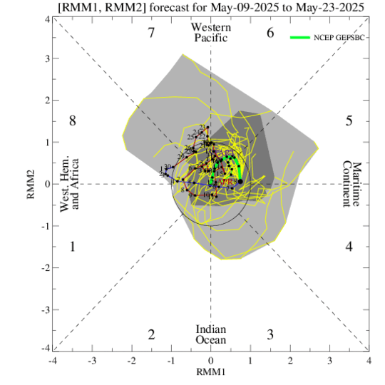
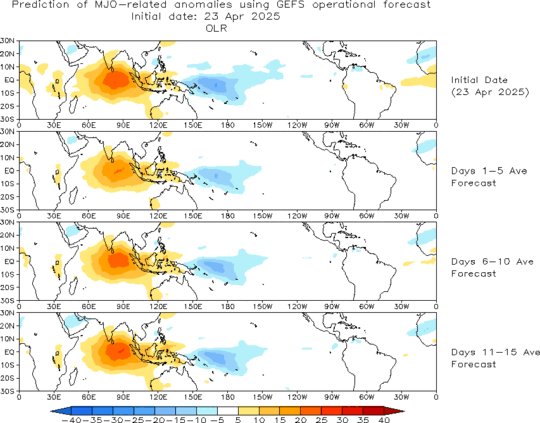
a very strong mjo is currently over the western pacific. weakening is expected but should restrengthen back over the western pacific...

enhanced convection over our area in the near and long term.
0 likes
-
dexterlabio
- Category 5

- Posts: 3499
- Joined: Sat Oct 24, 2009 11:50 pm
Re: 2012 WPAC season
These just set things in action. I'll be watching the WPAC closely next week....I'm not really sure if we'll be seeing the 2nd TD or the 1st named storm of the season soon but it would be interesting if we see the WPAC getting alive as early as now.
Euro is also showing 2 systems now, the other one being strong in SCS while the other being weaker off Mindanao. That's long-range, though.
Euro is also showing 2 systems now, the other one being strong in SCS while the other being weaker off Mindanao. That's long-range, though.
0 likes
Personal Forecast Disclaimer:
The posts in this forum are NOT official forecast and should not be used as such. They are just the opinion of the poster and may or may not be backed by sound meteorological data. They are NOT endorsed by any professional institution or storm2k.org. For official information, please refer to the NHC and NWS products.
The posts in this forum are NOT official forecast and should not be used as such. They are just the opinion of the poster and may or may not be backed by sound meteorological data. They are NOT endorsed by any professional institution or storm2k.org. For official information, please refer to the NHC and NWS products.
- cycloneye
- Admin

- Posts: 148730
- Age: 69
- Joined: Thu Oct 10, 2002 10:54 am
- Location: San Juan, Puerto Rico
Re: 2012 WPAC season
GFS has a storm South of Guam but is very long range.It has been showing it in past runs but the timeframe has gone back in the runs.Let's see as more runs come to see if it continues to show it and if the ECMWF joins GFS.

Uploaded with ImageShack.us

Uploaded with ImageShack.us
0 likes
Visit the Caribbean-Central America Weather Thread where you can find at first post web cams,radars
and observations from Caribbean basin members Click Here
and observations from Caribbean basin members Click Here
-
Typhoon Hunter
- WesternPacificWeather.com

- Posts: 1222
- Joined: Wed Oct 11, 2006 11:37 am
- Location: Tokyo
- Contact:
Hey Cycloneye - please could you let me know the link which you use to access those GFS charts?
Many thanks!
Regarding El Nino / La Nina effects on typhoon activity I always understood (simply speaking) that El Nino = more storm with activity closer to dateline, La Nina = less storm but activity further west closer to Asian landmass.
Many thanks!
Regarding El Nino / La Nina effects on typhoon activity I always understood (simply speaking) that El Nino = more storm with activity closer to dateline, La Nina = less storm but activity further west closer to Asian landmass.
0 likes
- cycloneye
- Admin

- Posts: 148730
- Age: 69
- Joined: Thu Oct 10, 2002 10:54 am
- Location: San Juan, Puerto Rico
Re:
Typhoon Hunter wrote:Hey Cycloneye - please could you let me know the link which you use to access those GFS charts?
Many thanks!
Regarding El Nino / La Nina effects on typhoon activity I always understood (simply speaking) that El Nino = more storm with activity closer to dateline, La Nina = less storm but activity further west closer to Asian landmass.
Link here! Click where you see "Model Guidance".
http://mag.ncep.noaa.gov/NCOMAGWEB/appcontroller
0 likes
Visit the Caribbean-Central America Weather Thread where you can find at first post web cams,radars
and observations from Caribbean basin members Click Here
and observations from Caribbean basin members Click Here
-
Typhoon Hunter
- WesternPacificWeather.com

- Posts: 1222
- Joined: Wed Oct 11, 2006 11:37 am
- Location: Tokyo
- Contact:
- cycloneye
- Admin

- Posts: 148730
- Age: 69
- Joined: Thu Oct 10, 2002 10:54 am
- Location: San Juan, Puerto Rico
Re: 2012 WPAC season
The first Tropical Storm of the 2012 season has been born and the name is Pakhar per official agency JMA.
0 likes
Visit the Caribbean-Central America Weather Thread where you can find at first post web cams,radars
and observations from Caribbean basin members Click Here
and observations from Caribbean basin members Click Here
-
dexterlabio
- Category 5

- Posts: 3499
- Joined: Sat Oct 24, 2009 11:50 pm
Re: 2012 WPAC season
hooray we're starting as early as March. the one we got now is not like typical TD's that come and go. It looks amazing.
0 likes
Personal Forecast Disclaimer:
The posts in this forum are NOT official forecast and should not be used as such. They are just the opinion of the poster and may or may not be backed by sound meteorological data. They are NOT endorsed by any professional institution or storm2k.org. For official information, please refer to the NHC and NWS products.
The posts in this forum are NOT official forecast and should not be used as such. They are just the opinion of the poster and may or may not be backed by sound meteorological data. They are NOT endorsed by any professional institution or storm2k.org. For official information, please refer to the NHC and NWS products.
- cycloneye
- Admin

- Posts: 148730
- Age: 69
- Joined: Thu Oct 10, 2002 10:54 am
- Location: San Juan, Puerto Rico
Re: 2012 WPAC season
My question about the different intensity warnings by JMA and JTWC regarding Pakhar is,why in this case there was a big difference that had JTWC with 65kts and JMA which remained at 40kts?
0 likes
Visit the Caribbean-Central America Weather Thread where you can find at first post web cams,radars
and observations from Caribbean basin members Click Here
and observations from Caribbean basin members Click Here
-
euro6208
Re: 2012 WPAC season
JMA uses 10 minute and because of this, they will always be on the low side. JTWC uses 1 minute like NHC and they use the same dvorak system so to me, JTWC is the most trusted. there have been many storms over here with eye like feature but JMA wouldn't upgrade. thank god for jtwc!!
0 likes
- P.K.
- Professional-Met

- Posts: 5149
- Joined: Thu Sep 23, 2004 5:57 pm
- Location: Watford, England
- Contact:
Re: 2012 WPAC season
cycloneye wrote:My question about the different intensity warnings by JMA and JTWC regarding Pakhar is,why in this case there was a big difference that had JTWC with 65kts and JMA which remained at 40kts?
There was quite a variation the other day. Several agencies were in the 40kt/45kt range, HKO had a STS (not sure what wind speed they had), CMA at 55kts and JTWC at 65kts. The JMA tend to rely on their own Dvorak bulletins so must have had it around a T3.0 instead of the T4.0 I saw from the SAB at least.
0 likes
- cycloneye
- Admin

- Posts: 148730
- Age: 69
- Joined: Thu Oct 10, 2002 10:54 am
- Location: San Juan, Puerto Rico
Re: 2012 WPAC season
P.K. wrote:cycloneye wrote:My question about the different intensity warnings by JMA and JTWC regarding Pakhar is,why in this case there was a big difference that had JTWC with 65kts and JMA which remained at 40kts?
There was quite a variation the other day. Several agencies were in the 40kt/45kt range, HKO had a STS (not sure what wind speed they had), CMA at 55kts and JTWC at 65kts. The JMA tend to rely on their own Dvorak bulletins so must have had it around a T3.0 instead of the T4.0 I saw from the SAB at least.
Wow,what a spread by them. Thanks for the answer.
0 likes
Visit the Caribbean-Central America Weather Thread where you can find at first post web cams,radars
and observations from Caribbean basin members Click Here
and observations from Caribbean basin members Click Here
- cycloneye
- Admin

- Posts: 148730
- Age: 69
- Joined: Thu Oct 10, 2002 10:54 am
- Location: San Juan, Puerto Rico
Re: 2012 WPAC season
0 likes
Visit the Caribbean-Central America Weather Thread where you can find at first post web cams,radars
and observations from Caribbean basin members Click Here
and observations from Caribbean basin members Click Here
-
Typhoon Hunter
- WesternPacificWeather.com

- Posts: 1222
- Joined: Wed Oct 11, 2006 11:37 am
- Location: Tokyo
- Contact:
Re: 2012 WPAC season
Thanks for posting that Cycloneye!
There's a horrible and glaring typo in their forecast:
"There is a 22% probability that the 2012 Atlantic hurricane season ACE index will be above-average (defined as an ACE index value in the upper tercile historically (>336)), a 38% likelihood it will be nearnormal (defined as an ACE index value in the middle tercile historically (235 to 336) and a 40% chance it will be below-normal (defined as an ACE index value in the lower tercile historically (<235))."
0 likes
-
Typhoon Hunter
- WesternPacificWeather.com

- Posts: 1222
- Joined: Wed Oct 11, 2006 11:37 am
- Location: Tokyo
- Contact:
Re: 2012 WPAC season
euro6208 wrote:JMA uses 10 minute and because of this, they will always be on the low side. JTWC uses 1 minute like NHC and they use the same dvorak system so to me, JTWC is the most trusted. there have been many storms over here with eye like feature but JMA wouldn't upgrade. thank god for jtwc!!
LOL, each to their own. I remember this system in 2009 which JTWC were warning at 35kts:

Uploaded with ImageShack.us
0 likes
Who is online
Users browsing this forum: JoshwaDone and 62 guests
