2012 SE TX/SW LA Weather:Cold/cool week.

U.S. & Caribbean Weather Discussions and Severe Weather Events

Moderator: S2k Moderators

Forum rules

The posts in this forum are NOT official forecast and should not be used as such. They are just the opinion of the poster and may or may not be backed by sound meteorological data. They are NOT endorsed by any professional institution or STORM2K.

Help Support Storm2K
Message
Author
User avatar
Annie Oakley
Category 5
Category 5
Posts: 1103
Joined: Tue Jul 31, 2007 12:54 pm
Location: Texas

Re: 2012 SE TX/SW LA Weather: Late week rainfall and flooding?

#21 Postby Annie Oakley » Fri Mar 09, 2012 10:14 pm

vbhoutex wrote:I posted this in the Winter Weather forum too. What is one to do?
What a difference one day makes!!! Yesterday I was in shorts and tshirts with light rain and 78F. Today I'm in jeans and long sleeves with rain and 48F!! :eek: :roll: Can't even figure out which thread I should be posting in, this one or the non-winter thread :?: :eek: :roll:


We don't care which one ha ha-just keep posting for us. You are great and we will follow! :D
0 likes   

User avatar
vbhoutex
Storm2k Executive
Storm2k Executive
Posts: 29112
Age: 73
Joined: Wed Oct 09, 2002 11:31 pm
Location: Cypress, TX
Contact:

Re: 2012 SE TX/SW LA Weather: Late week rainfall and flooding?

#22 Postby vbhoutex » Sat Mar 10, 2012 10:26 am

Why thanks Annie! We had rain and thunder off and on overnight. Emptied 1.65" out of the gauge this am. Haven't wavered more than a degree either way from 48f for at least the last 24 hrs. I believe will will officially be out of the drought before the end of this month if the weather pattern holds as expected for the next month or so. Of course we need to make up for more than just last year, but that won't necessarily keep us in drought. I guess yard work is out of the question today. It is raining again.
0 likes   
Skywarn, C.E.R.T.
Please click below to donate to STORM2K to help with the expenses of keeping the site going:
Image

User avatar
TexasSam
Category 2
Category 2
Posts: 573
Age: 66
Joined: Thu Aug 28, 2003 12:16 am
Location: Port Arthur, Texas

Re: 2012 SE TX/SW LA Weather: Late week rainfall and flooding?

#23 Postby TexasSam » Sun Mar 11, 2012 10:20 am

I didn't see this anyplace so here goes...

MESOSCALE DISCUSSION 0240
NWS STORM PREDICTION CENTER NORMAN OK
0756 AM CDT SUN MAR 11 2012

AREAS AFFECTED...SOUTHEAST/EAST-CENTRAL TX TO FAR WESTERN LA

CONCERNING...SEVERE POTENTIAL...WATCH POSSIBLE

VALID 111256Z - 111530Z

AN ISOLATED TORNADO/DAMAGING WIND POTENTIAL MAY DEVELOP/GRADUALLY
INCREASE THIS MORNING ACROSS PORTIONS OF SOUTHEAST INTO EAST-CENTRAL
TX/EVENTUALLY FAR WESTERN LA. INITIAL THINKING IS THAT A WATCH COULD
BE NEEDED AS EARLY AS MID/LATE MORNING ACROSS THE REGION.

PER LATEST SURFACE ANALYSIS...A MODIFIED GULF AIRMASS WITH
MIDDLE/UPPER 60S F SURFACE DEWPOINTS CONTINUES TO SLOWLY SPREAD
NORTHWARD ALONG THE UPPER TX COAST EARLY THIS MORNING. WITH ELEVATED
TSTMS ONGOING EARLY DAY ACROSS THE TX HILL COUNTRY...THE GRAZING
SOUTHERN INFLUENCE OF A CLOSED CYCLONE CENTERED/MOVING NORTHEASTWARD
OVER THE SOUTHERN HIGH PLAINS WILL LIKELY INTERACT WITH THIS
INCREASINGLY MOIST/POTENTIALLY UNSTABLE AIRMASS ACROSS SOUTHEAST
INTO EAST-CENTRAL TX/FAR WESTERN LA TODAY. AS SUCH...SURFACE BASED
TSTMS ARE LIKELY TO BECOME MORE PREVALENT WITHIN THE WARM/MOIST
SECTOR AHEAD OF A SLOW MOVING SURFACE TROUGH/WEAK FRONT...WITH
INCIPIENT SIGNS OF WEAK SUPERCELL STRUCTURES/INCREASING CG LIGHTNING
ALREADY NOTED NORTH OF HOUSTON VICINITY. ACCORDINGLY...THE LATEST
NUMERICAL GUIDANCE...INCLUDING CONVECTION ALLOWING MODELS SUCH AS
THE 00Z WRF-NMM AND SPC EXPERIMENTAL SSEO...IMPLY THAT STORMS SHOULD
GRADUALLY DEVELOP/MATURE INTO LATE MORNING/MIDDAY WITHIN A
PERSISTENT SSW-NNE CORRIDOR OF INCREASING MOIST/CONFLUENT LOW-LEVEL
FLOW. GIVEN THIS ANTICIPATED EVOLUTION/THERMODYNAMIC TRENDS...SHEAR
PROFILES COINCIDENT WITH THE ENTRANCE REGION OF A MODERATELY STRONG
SOUTHERLY LOW LEVEL JET WILL BE FAVORABLE FOR ISOLATED/EMBEDDED
SUPERCELL STRUCTURES CAPABLE OF A FEW TORNADOES ALONG WITH DAMAGING
WINDS/SOME HAIL.

..GUYER.. 03/11/2012
0 likes   

User avatar
TexasSam
Category 2
Category 2
Posts: 573
Age: 66
Joined: Thu Aug 28, 2003 12:16 am
Location: Port Arthur, Texas

Re: 2012 SE TX/SW LA Weather: Late week rainfall and flooding?

#24 Postby TexasSam » Sun Mar 11, 2012 11:43 am

BULLETIN - EAS ACTIVATION REQUESTED
SEVERE THUNDERSTORM WARNING
NATIONAL WEATHER SERVICE HOUSTON/GALVESTON TX
1135 AM CDT SUN MAR 11 2012

THE NATIONAL WEATHER SERVICE IN LEAGUE CITY HAS ISSUED A

* SEVERE THUNDERSTORM WARNING FOR...
NORTHERN BRAZORIA COUNTY IN SOUTHEAST TEXAS...
EASTERN FORT BEND COUNTY IN SOUTHEAST TEXAS...
CENTRAL HARRIS COUNTY IN SOUTHEAST TEXAS...

* UNTIL NOON CDT

* AT 1127 AM CDT...NATIONAL WEATHER SERVICE DOPPLER RADAR INDICATED A
LINE OF SEVERE THUNDERSTORMS CAPABLE OF PRODUCING DAMAGING WINDS IN
EXCESS OF 60 MPH. THESE STORMS WERE LOCATED ALONG A LINE EXTENDING
FROM JERSEY VILLAGE TO BELLAIRE TO 13 MILES SOUTHWEST OF MANVEL...
OR ALONG A LINE EXTENDING FROM JERSEY VILLAGE TO BELLAIRE TO 12
MILES NORTH OF ANGLETON...AND MOVING NORTHEAST AT 35 MPH.

* LOCATIONS IN THE SEVERE THUNDERSTORM WARNING INCLUDE BUT ARE NOT
LIMITED TO THE MEDICAL CENTER...RELIANT PARK...MINUTE MAID PARK...
HOBBY AIRPORT...HERMAN PARK...THE GALLERIA...BUSH-INTERCONTINENTAL
AIRPORT...WEST UNIVERSITY PLACE...SPRING VALLEY...SOUTHSIDE
PLACE...SOUTH HOUSTON...PINEY POINT VILLAGE...PEARLAND...MISSOURI
CITY...KINGWOOD...JACINTO CITY...HUNTERS CREEK VILLAGE...HUMBLE...
HOUSTON...HEDWIG VILLAGE...GALENA PARK...FRESNO...CLOVERLEAF...
BUNKER HILL VILLAGE...BROOKSIDE VILLAGE...ALVIN AND ALDINE.

PRECAUTIONARY/PREPAREDNESS ACTIONS...

STRONG WINDS MAY KNOCK DOWN TREES AND POWER LINES OR DAMAGE
BUILDINGS. TAKE COVER NOW!
0 likes   

User avatar
Rgv20
S2K Supporter
S2K Supporter
Posts: 2466
Age: 38
Joined: Wed Jan 05, 2011 5:42 pm
Location: Edinburg/McAllen Tx

#25 Postby Rgv20 » Sun Mar 11, 2012 2:50 pm

Image

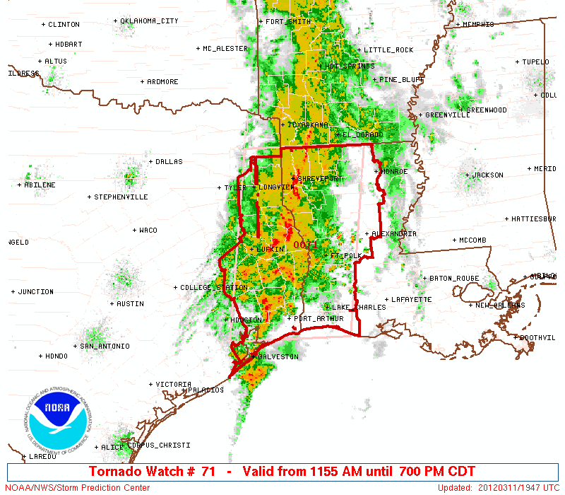
URGENT - IMMEDIATE BROADCAST REQUESTED
TORNADO WATCH NUMBER 71
NWS STORM PREDICTION CENTER NORMAN OK
1155 AM CDT SUN MAR 11 2012

THE NWS STORM PREDICTION CENTER HAS ISSUED A
TORNADO WATCH FOR PORTIONS OF

SOUTHWEST AND NORTHERN LOUISIANA
EAST TEXAS
COASTAL WATERS

EFFECTIVE THIS SUNDAY MORNING AND EVENING FROM 1155 AM UNTIL 700
PM CDT.

TORNADOES...HAIL TO 1.5 INCHES IN DIAMETER...THUNDERSTORM WIND
GUSTS TO 70 MPH...AND DANGEROUS LIGHTNING ARE POSSIBLE IN THESE
AREAS.

THE TORNADO WATCH AREA IS APPROXIMATELY ALONG AND 75 STATUTE
MILES EAST AND WEST OF A LINE FROM 45 MILES NORTH NORTHEAST OF
SHREVEPORT LOUISIANA TO 25 MILES SOUTH OF PORT ARTHUR TEXAS. FOR
A COMPLETE DEPICTION OF THE WATCH SEE THE ASSOCIATED WATCH
OUTLINE UPDATE (WOUS64 KWNS WOU1).

REMEMBER...A TORNADO WATCH MEANS CONDITIONS ARE FAVORABLE FOR
TORNADOES AND SEVERE THUNDERSTORMS IN AND CLOSE TO THE WATCH
AREA. PERSONS IN THESE AREAS SHOULD BE ON THE LOOKOUT FOR
THREATENING WEATHER CONDITIONS AND LISTEN FOR LATER STATEMENTS
AND POSSIBLE WARNINGS.

DISCUSSION...STORMS ARE GRADUALLY INCREASING IN INTENSITY OVER SERN
TX AS THE SRN END OF A SHORT WAVE TROUGH ROTATES NEWD ACROSS CENTRAL
TX. STRONG SOUTHERLY LOW LEVEL WINDS ARE TRANSPORTING MOISTURE NWD
TOWARD THE ARKLATEX REGION...WITH SUBSEQUENT DESTABILIZATION
EXPECTED THROUGH THE AFTERNOON. LATEST KHGX VWP INDICATES STRONG
LOW- AND DEEP LAYER SHEAR ASSOCIATED WITH A CLOCKWISE TURNING
HODOGRAPH FAVORABLE FOR SUPERCELLS AND A THREAT FOR A FEW TORNADOES
TO DEVELOP. ACTIVITY WILL DEVELOP NEWD WITH ADDITIONAL RISK FOR
DAMAGING WIND GUSTS WITHIN SMALL-SCALE BOWING LINE SEGMENTS.

AVIATION...TORNADOES AND A FEW SEVERE THUNDERSTORMS WITH HAIL
SURFACE AND ALOFT TO 1.5 INCHES. EXTREME TURBULENCE AND SURFACE
WIND GUSTS TO 60 KNOTS. A FEW CUMULONIMBI WITH MAXIMUM TOPS TO
450. MEAN STORM MOTION VECTOR 23035.


...WEISS
0 likes   
The following post is NOT an official forecast and should not be used as such. It is just the opinion of the poster and may or may not be backed by sound meteorological data. It is NOT endorsed by any professional institution including storm2k.org For Official Information please refer to the NHC and NWS products.

User avatar
vbhoutex
Storm2k Executive
Storm2k Executive
Posts: 29112
Age: 73
Joined: Wed Oct 09, 2002 11:31 pm
Location: Cypress, TX
Contact:

Re: 2012 SE TX/SW LA Weather: Late week rainfall and flooding?

#26 Postby vbhoutex » Sun Mar 11, 2012 3:43 pm

That line put down TORRENTIAL downpours as it went through the Memorial and Spring Branch areas of Houston this am. I was in church so didn't get to eyeball much, but the rainfall rate where I was had to be close to or over 2"/hr. At my house, about 5 miles N of the church we went well over an inch(haven't emptied gauge yet) and almost got water in the house again because it wasn't draining out of the back patio area fast enough. I wasn't home but my wife was and she just put down a towel where she thought the water would come in. Fortunately it didn't. I have no way of knowing for sure about the amount at the church but I would take bets it went well over 2" in less than an hour. Fortunately it appears our rain is over for a long while if not for good. The rain today will put us over or just at 3.5" in the last 4 days. WE ARE SOGGY! A far cry from what we experienced last year. Hopefully this is buh bye short term drought and watch out long term drought.

edit-3/12-final for the event is 3.49"
0 likes   
Skywarn, C.E.R.T.
Please click below to donate to STORM2K to help with the expenses of keeping the site going:
Image

CajunMama
Retired Staff
Retired Staff
Posts: 10791
Joined: Thu Feb 06, 2003 9:57 pm
Location: 30.22N, 92.05W Lafayette, LA

Re: 2012 SE TX/SW LA Weather: Late week rainfall and flooding?

#27 Postby CajunMama » Mon Mar 12, 2012 9:40 am

We've had a good amount of rain. Radar estimates are 1.5"-2.5" where I live. BUT...where my son lives a few miles north of I-10 he's received 8"-10" of rain. He says they're high and they should be ok. Yikes!
0 likes   

User avatar
PTrackerLA
Category 5
Category 5
Posts: 5277
Age: 41
Joined: Thu Oct 10, 2002 8:40 pm
Location: Lafayette, LA

Re: 2012 SE TX/SW LA Weather: Late week rainfall and flooding?

#28 Postby PTrackerLA » Mon Mar 12, 2012 11:47 am

So much for the dynamics "lifting out" last night before this system got to us. Storms have trained all morning in north part of Lafayette Parish and doppler is estimating up to 15" of rain has fallen around Carencro! Lots of road closures and rescues ongoing now and the storms don't look over yet!
0 likes   

User avatar
PTrackerLA
Category 5
Category 5
Posts: 5277
Age: 41
Joined: Thu Oct 10, 2002 8:40 pm
Location: Lafayette, LA

#29 Postby PTrackerLA » Mon Mar 12, 2012 11:50 am

Latest flash flood bulletin. The main city of Lafayette just missed this rain by about 20 miles to the north. We would be experiencing terrible flooding in the city right now, unfortunately the outlying areas are getting the brunt:

BULLETIN - EAS ACTIVATION REQUESTED
FLASH FLOOD WARNING
NATIONAL WEATHER SERVICE LAKE CHARLES LA
1128 AM CDT MON MAR 12 2012

THE NATIONAL WEATHER SERVICE IN LAKE CHARLES HAS ISSUED A

* AT 1121 AM CDT...LOCAL LAW ENFORCEMENT OFFICIALS REPORTED
FLOODING ACROSS THE WARNED AREA WITH NUMEROUS ROADS AND HOMES
FLOODED. IN ADDITION SEVERAL HIGH WATER RESCUES ARE UNDERWAY.
RAINFALL ESTIMATES OF AROUND 15 INCHES HAVE FALLEN IN THE PAST
SIX HOURS. THIS IS A RARE EVENT AND MAY CAUSE SOME LOCATIONS
LIKE BAYOU VERMILION AT CARENCRO TO REACH RECORD FLOODING.
MANY ROADS ARE CLOSED AND YOU SHOULD NOT TRAVEL IN THIS AREA TODAY.

THIS IS A FLASH FLOOD EMERGENCY FOR NORTHERN LAFAYETTE PARISH.


Can't remember ever seeing a flash flood emergency around here!
0 likes   

User avatar
AdamFirst
S2K Supporter
S2K Supporter
Posts: 2491
Age: 36
Joined: Thu Aug 14, 2008 10:54 am
Location: Port Saint Lucie, FL

#30 Postby AdamFirst » Mon Mar 12, 2012 12:22 pm

Freak flash flooding event, for sure. Heavy rain just keeps on training over the same area.
0 likes   
Dolphins Marlins Canes Golden Panthers HEAT
Andrew 1992 - Irene 1999 - Frances 2004 - Jeanne 2004 - Wilma 2005 - Fay 2008 - Isaac 2012 - Matthew 2016 - Irma 2017 - Dorian 2019 - Ian 2022 - Nicole 2022 - Milton 2024

User avatar
PTrackerLA
Category 5
Category 5
Posts: 5277
Age: 41
Joined: Thu Oct 10, 2002 8:40 pm
Location: Lafayette, LA

Re: 2012 SE TX/SW LA Weather: Late week rainfall and flooding?

#31 Postby PTrackerLA » Mon Mar 12, 2012 4:58 pm

A closeup of the rainfall totals provided by NWS Lake Charles. It's been quite a few years since I've seen totals this high with any event, thankfully they were fairly localized to one area:

Image
0 likes   

CajunMama
Retired Staff
Retired Staff
Posts: 10791
Joined: Thu Feb 06, 2003 9:57 pm
Location: 30.22N, 92.05W Lafayette, LA

#32 Postby CajunMama » Mon Mar 12, 2012 6:16 pm

My sons home was fine! Now the neighborhood before his...not good at all. This is only 1/2 mile from his home.

Image
And yes, as you can see by his arm at the bottom of the picture he was driving on a flooded street. I thought i taught him better!
0 likes   

User avatar
Cyclenall
Category 5
Category 5
Posts: 6666
Joined: Thu Jun 08, 2006 10:01 pm
Location: Ontario, Canada

Funny as heck

#33 Postby Cyclenall » Wed Mar 14, 2012 7:35 pm

CajunMama wrote:As hurricane girl used to say, "Holy Crap :eek: " Lawdy this storm actually had me scared. Ferocious winds, hail, thunder, lightning. I wanted to be my dog so I could snuggle and hide like he did!

That is the funniest thing I have read on S2K in ages :lol: .
0 likes   

Jagno
Category 3
Category 3
Posts: 825
Joined: Tue Sep 07, 2004 10:40 pm
Location: SW Louisiana

Re: 2012 SE TX/SW LA Weather: Late week rainfall and flooding?

#34 Postby Jagno » Wed Mar 14, 2012 11:38 pm

Well I'm beginning to think I'm going to have to run some leader lines to find my dogs if this ground doesn't dry up enough to mow soon. Seriously though we were truly blessed with good drainage for the first time in 29 years. I've been fussing and complaining for months over the road construction, which tore up a perfectly good road, and it was all to install some really fine drainage to our area finally. This past weeks rain event had all of us promising to never complain about the noise and dust again because it was well worth not having to wear rubber boots to get out of your door after a soaking rain.

It looks to be a cloudy and warm week ahead. I'll take what I can get.

Okay, so it looks like we can put away our winter jackets. It's official. I left my cell phone in the car from noon until 4pm and my cell phone battery became overheated which caused all kinds of combustion warnings on my phone. I had to take the battery out completely until it cooled down. LOL
0 likes   

Jagno
Category 3
Category 3
Posts: 825
Joined: Tue Sep 07, 2004 10:40 pm
Location: SW Louisiana

Re: 2012 SE TX/SW LA Weather: Late week rainfall and flooding?

#35 Postby Jagno » Sun Mar 18, 2012 10:16 pm

Wow, I checked the NWS just to get an idea of our work week weather and it's loaded with watches, advisories and hazardous weather outlooks on everything from high winds, flooding and the potential setup for severe weather. It seems a cold front will make it's way through SE TX Tuesday morning, SW LA Tuesday afternoon & Central LA that evening. Ha, what a way to bring in our first day of spring on Tuesday.
Ahead of this system we are already seeing gusty winds but Monday they are expected to remain fairly strong and consistent. I love this in my SUV. This system is a slow mover so fears of the same areas receiving copius amounts of rain last week getting it again is almost a certainty. It looks like some of these could be severe so everyone be safe.
0 likes   

User avatar
vbhoutex
Storm2k Executive
Storm2k Executive
Posts: 29112
Age: 73
Joined: Wed Oct 09, 2002 11:31 pm
Location: Cypress, TX
Contact:

Re: 2012 SE TX/SW LA Weather: Late week rainfall and flooding?

#36 Postby vbhoutex » Mon Mar 19, 2012 8:45 am

Latest for Jeff Lindner looks like a rough early week in SE TX.
Significant severe weather event including the potential for strong tornadoes increasingly likely this afternoon through Tuesday.

Heavy rainfall and flash flooding also likely on Tuesday.

SPC has upgraded the severe threat to a moderate risk for much of central and north TX
.

Discussion:

Powerful upper level storm system will move slowly into the southern plains today/Tuesday with widespread downstream thunderstorm development over TX. Parameters appear to be coming together for a widespread severe weather event across much of the state this afternoon-Tuesday. Combination of increasingly cooler air aloft over heated surface air, strong jet stream dynamics, tremendous wind energy, and favorable instability all point to severe weather including tornadoes…a few strong.

As large scale forcing increases this afternoon over central TX, expect to see rapid development of isolate supercells capable of very large hail (baseball size or larger) and tornadoes. Meso scale models show numerous supercells developing in the 300-800pm period this evening roughly along the I-35 corridor in central TX with fairly rapid upscale growth into a large line of severe thunderstorms extending from SW MO to S TX overnight/early Tuesday. Initial cells will be a higher tornado threat (see SPC moderate risk outline below) in the region of favorable backed low level flow lending strong low level shear in a very moist air mass. Strong squall line (possible bow echo…line of thunderstorm with widespread wind damage) appears possible after midnight across central and SC TX in the region of strong jet dynamics and favorable low level Gulf inflow (low level jet of 50kts+ over the middle/upper TX coast). Strong mid level flow of 60-80kts plowing into the underside of the upper level storm and the backside of the squall line suggest wind damage is likely with this line. Surface wind gusts to 60-70mph will be possible with the squall line.

Line should approach our western counties between 200-400am and then slow some reaching the I-45 corridor between 600-1000am. Still some questions on timing as the models slow the line as the main upper storm slows down however strong cold pool generation could help shove this line faster to the east than the meso models are suggesting. Some concern than meso low formation on the line just north of SE TX could result in a buckling and slowing/stalling of the line over some portion of the area on Tuesday into Tuesday night which would keep a severe and then significant flash flood threat into Tuesday night.

Severe Impacts:

Damaging winds of 60mph or greater appear to be the greatest threat at this time with large hail and tornadoes a close second. Wind threat will increase overnight into early Tuesday with the greatest tornado threat this evening and then again on Tuesday after mid morning as the air mass heats. As is usual with these types of squall lines in SE TX brief tornadoes will be possible along the leading edge of the line with little warning.

Heavy Rainfall:

Starting to get a little concerned with a few of the models trying to slow and stall the line of storms over the area on Tuesday-Tuesday night. Moisture levels will be increasing to near 200% of normal today and with very favorable low level inflow off the Gulf and strong upper level divergence aloft the red flags for excessive rainfall are in place. Main question is does the storms move through or slow enough to drop 4-5 inches of rainfall in a few hours. Given the amounts of moisture that will be in place combined with the threat for slowing storm motions and training of cells some hefty short term totals will be possible. Models have been bouncing around with the idea of widespread amounts of 2-4 inches across various areas of SE TX and the latest HPC output shows a large swath of 2-4 inches over the area with a bullseye of 6.42 inches just east of metro Houston. Given the likelihood of high short term rainfall rates of (1-3 inches per hour) urban ponding/flooding on streets and areas of poor drainage is likely. Grounds are already wet from previous rainfall and run-off will be enhanced with this event producing rises on area watersheds. Flash Flood Watches have been issued for central and north TX and a watch may be required for parts of SE TX later today.

Hydro:

Several rivers are still seeing higher than normal flows from the last round of heavy rainfall and based on the current forecast several basins will see additional widespread very heavy rains tonight-Wednesday. Form the WGRFC in Fort Worth:

Moderate River flooding is likely on the: Upper Sabine, Upper Neches, and middle Trinity Rivers.

Moderate River flooding is possible on the: Middle Brazos, middle Colorado, upper Guadalupe, and upper San Antonio Rivers.

Rises to flood stage will be possible on smaller creeks and bayous across the state.

***Remember to never drive into high water even if it is “not deep”. Always turn around don’t drown!

Tornado Safety:

We have seen the large tornado outbreaks over the past year and TX has been largely spared in part due to the drought. The following tips are reminders of what to do if a tornado approaches your location:

Seek shelter in a strong sturdy building, abandon poor constructed housing

Abandon mobile homes for strong shelter, if no shelter is available lie flat in a ditch or low area and cover your head with your hands.

In a strongly built structure move to an interior room on the lowest floor of the location away from windows and outside facing walls. Cover yourself with pillows and blankets to protect from flying debris.

Never tie to outrun a tornado…abandon vehicles for strong shelter, if a strong shelter is not available lie flat in a ditch an d cover your head…DO NOT hide under freeway overpasses…they act as wind tunnels and increase the wind speeds under and around them
0 likes   
Skywarn, C.E.R.T.
Please click below to donate to STORM2K to help with the expenses of keeping the site going:
Image

User avatar
PTrackerLA
Category 5
Category 5
Posts: 5277
Age: 41
Joined: Thu Oct 10, 2002 8:40 pm
Location: Lafayette, LA

Re: 2012 SE TX/SW LA Weather: Late week rainfall and flooding?

#37 Postby PTrackerLA » Mon Mar 19, 2012 10:16 am

Looks like 3"-6"+ of rain area wide over the next 3 days which could have a significant flooding impact on area rivers. The Vermilion River in Lafayette is above flood stage and STILL slowly rising for the 15" of rain that fell in parts of the watershed a week ago now. If we were to have 6" of rain in the city we could be threatening major flood status in the city, something that hasn't happened in quite some years now. On top of all this we will have a severe thunderstorm threat Tues-Thurs as well. Here we go again!
0 likes   

User avatar
JenBayles
Category 5
Category 5
Posts: 3461
Age: 62
Joined: Tue Aug 26, 2003 3:27 pm
Location: Houston, TX
Contact:

Re: 2012 SE TX/SW LA Weather: Late week rainfall and flooding?

#38 Postby JenBayles » Mon Mar 19, 2012 6:12 pm

And so begins a night of little sleep....

Flash Flood Watch
FLOOD WATCH
NATIONAL WEATHER SERVICE HOUSTON/GALVESTON TX
300 PM CDT MON MAR 19 2012

TXZ163-164-176>179-195>200-210>214-226-227-235>238-202300-
/O.NEW.KHGX.FF.A.0002.120320T0800Z-120320T2300Z/
/00000.0.ER.000000T0000Z.000000T0000Z.000000T0000Z.OO/
AUSTIN-BRAZORIA-BRAZOS-BURLESON-CHAMBERS-COLORADO-FORT BEND-
GALVESTON-GRIMES-HARRIS-HOUSTON-JACKSON-LIBERTY-MADISON-MATAGORDA-
MONTGOMERY-POLK-SAN JACINTO-TRINITY-WALKER-WALLER-WASHINGTON-
WHARTON-
INCLUDING THE CITIES OF...ALVIN...ANAHUAC...ANGLETON...BAY CITY...
BELLVILLE...BRENHAM...BROOKSHIRE...BRYAN...CALDWELL...CLEVELAND...
COLDSPRING...COLLEGE STATION...COLUMBUS...CONROE...CORRIGAN...
CROCKETT...DAYTON...EAGLE LAKE...EDNA...EL CAMPO...FREEPORT...
FRIENDSWOOD...GALVESTON...GROVETON...HEMPSTEAD...HOUSTON...
HUMBLE...HUNTSVILLE...KATY...LAKE JACKSON...LAKE SOMERVILLE...
LEAGUE CITY...LIBERTY...LIVINGSTON...MADISONVILLE...
MISSOURI CITY...MONT BELVIEU...NAVASOTA...ONALASKA...PALACIOS...
PASADENA...PEARLAND...PIERCE...PRAIRIE VIEW...RICHMOND...
ROSENBERG...SEALY...SHEPHERD...SUGAR LAND...TEXAS CITY...
THE WOODLANDS...TOMBALL...TRINITY...WEIMAR...WHARTON...WILLIS...
WINNIE
300 PM CDT MON MAR 19 2012

...FLASH FLOOD WATCH IN EFFECT FROM LATE TONIGHT THROUGH TUESDAY AFTERNOON...

THE NATIONAL WEATHER SERVICE IN HOUSTON/GALVESTON HAS ISSUED A

* FLASH FLOOD WATCH FOR A PORTION OF SOUTHEAST TEXAS...INCLUDING
THE FOLLOWING COUNTIES...AUSTIN...BRAZORIA...BRAZOS...
BURLESON...CHAMBERS...COLORADO...FORT BEND...GALVESTON...
GRIMES...HARRIS...HOUSTON...JACKSON...LIBERTY...MADISON...
MATAGORDA...MONTGOMERY...POLK...SAN JACINTO...TRINITY...
WALKER...WALLER...WASHINGTON AND WHARTON.

* FROM LATE TONIGHT THROUGH TUESDAY AFTERNOON

* STRONG SOUTH TO SOUTHEAST WINDS WILL CONTINUE TO PUMP VERY DEEP
TROPICAL MOISTURE INTO CENTRAL AND EAST TEXAS AS A VERY STRONG
AND INTENSE MID AND UPPER LEVEL STORM SYSTEM OUT WEST SLOWLY
WORKS ITS WAY EASTWARD INTO THE STATE. SHOWERS AND THUNDERSTORMS
ARE POSSIBLE THROUGH THIS EVENING...BUT THE EXPECTED RAPID
MOVEMENT OF ANYTHING THAT DOES DEVELOP SHOULD KEEP RAINFALL
TOTALS ON THE LIGHT TO MODERATE SIDE. INCREASING STORM COVERAGE
HAS ALREADY BEGUN ACROSS CENTRAL TEXAS...AND THIS ACTIVITY WILL
MOVE INTO OUR WESTERN COUNTIES BEFORE SUNRISE TUESDAY MORNING.
WITH STRONG LOW LEVEL WINDS CONTINUING TO PUMP THE DEEP TROPICAL
MOISTURE INTO THE AREA AND WITH EXTREMELY FAVORABLE WINDS
ALOFT...HEAVY RAINS ARE EXPECTED TO DEVELOP ALONG AND AHEAD OF A
SLOW MOVING FRONTAL BOUNDARY. THIS BOUNDARY WILL MOVE EASTWARD
DURING THE DAY ON TUESDAY AND WILL PRODUCE PERIODS OF HEAVY RAIN
FOR MUCH OF SOUTHEAST TEXAS. RAINFALL TOTALS ARE EXPECTED TO
AVERAGE 1 TO 3 INCHES WITH ISOLATED AMOUNTS OF 3 TO 5 INCHES OR
GREATER WHERE ANY TRAINING OF STORMS OCCURS. THE LOWER RAINFALL
AMOUNTS ARE GENERALLY EXPECTED SOUTH OF THE INTERSTATE 10
CORRIDOR...AND THE HIGHER AMOUNTS ARE ANTICIPATED TO BE NORTH OF
THE INTERSTATE 10 CORRIDOR. IT IS LIKELY THAT PORTIONS OF THE
TEXAS AND LOUISIANA AREA WILL RECEIVE 5 OR MORE INCHES OF RAIN
BEFORE THIS EVENT COMES TO AN END.

* HEAVY RAINS ARE EXPECTED TO COME TO AN END FROM WEST TO EAST AS
THE DAY PROGRESSES ON TUESDAY. HOWEVER...THERE IS CONCERN AS TO
HOW FAR EAST THE BOUNDARY WILL GET DUE TO THE LOCATION OF WHERE
THE CENTRAL TEXAS STORM SYSTEM EVENTUALLY STALLS. IF THE SYSTEM
MEANDERS A LITTLE FURTHER WEST THAN ANTICIPATED...THEN HEAVY
RAINFALL ACROSS EASTERN PORTIONS OF SOUTHEAST TEXAS MIGHT BE
SLOW TO MOVE EAST OF THE AREA...AND THIS COULD RESULT IN GREATER
RAINFALL TOTALS THAN CURRENTLY ANTICIPATED. ALSO...THERE ARE
SOME INDICATIONS THAT ADDITIONAL RAINFALL COULD DEVELOP TUESDAY
NIGHT THROUGH WEDNESDAY MORNING ACROSS PORTIONS OF SOUTHEAST
TEXAS. IF THIS OCCURS...ANY RAINS FALLING OVER ALREADY SOAKED
LOCATIONS COULD AGGRAVATE THE THREAT FOR FLOODING.


PRECAUTIONARY/PREPAREDNESS ACTIONS...

A FLASH FLOOD WATCH MEANS THAT CONDITIONS MAY DEVELOP THAT LEAD
TO FLASH FLOODING. FLASH FLOODING IS A VERY DANGEROUS SITUATION.

YOU SHOULD MONITOR LATER FORECASTS AND BE PREPARED TO TAKE ACTION
SHOULD FLASH FLOOD WARNINGS BE ISSUED.
0 likes   

User avatar
JenBayles
Category 5
Category 5
Posts: 3461
Age: 62
Joined: Tue Aug 26, 2003 3:27 pm
Location: Houston, TX
Contact:

Re: 2012 SE TX/SW LA Weather: Late week rainfall and flooding?

#39 Postby JenBayles » Mon Mar 19, 2012 6:29 pm

Texas Hill Country radar lighting up. Not looking forward to seeing what it will look like when this mess reaches Houston.

Image
0 likes   

User avatar
southerngale
Retired Staff
Retired Staff
Posts: 27418
Joined: Thu Oct 10, 2002 1:27 am
Location: Southeast Texas (Beaumont area)

#40 Postby southerngale » Tue Mar 20, 2012 11:37 am

I'm getting some potent storms today. Very heavy rain, coming down sideways in sheets at times, very windy, a LOT of thunder and lightning... a flash flood warning just issued here.


* FLASH FLOOD WARNING FOR...
EASTERN HARDIN COUNTY IN SOUTHEAST TEXAS...
NORTH CENTRAL JEFFERSON COUNTY IN SOUTHEAST TEXAS...

* UNTIL 230 PM CDT

* AT 1127 AM CDT...NATIONAL WEATHER SERVICE DOPPLER RADAR INDICATED
SLOW MOVING THUNDERSTORMS WITH VERY HEAVY RAINFALL ACROSS THE
WARNED AREA. RADAR AND RAIN GAUGE ESTIMATES OF 2 TO AS MUCH AS
5.5 INCHES HAVE FALLEN ACROSS THE AREA ALONG AND EAST OF A VILLAGE
MILLS...TO KOUNTZE TO BEVIL OAKS LINE.

* RUNOFF FROM THIS EXCESSIVE RAINFALL WILL CAUSE FLASH FLOODING TO
OCCUR. SOME LOCATIONS THAT WILL EXPERIENCE FLOODING INCLUDE...
KOUNTZE...LUMBERTON...SILSBEE...WILDWOOD...BEVIL OAKS...CANEY HEAD
AND VILLAGE MILLS.

THIS INCLUDES THE FOLLOWING STREAMS AND DRAINAGES BUT ARE NOT
LIMITED TO...CYPRESS CREEK...BLACK CREEK...KIMBALL CREEK...TURKEY
CREEK...VILLAGE CREEK...BEECH CREEK...MILL CREEK...WALKER
BRANCH...HICKORY CREEK...PINOAK BRANCH...BLACK BRANCH...BOGGY
CREEK...LITTLE ROCK CREEK...BIG SANDY CREEK.

PRECAUTIONARY/PREPAREDNESS ACTIONS...

A FLASH FLOOD WARNING MEANS THAT FLOODING IS IMMINENT OR OCCURRING.
IF YOU ARE IN THE WARNING AREA MOVE TO HIGHER GROUND IMMEDIATELY.
RESIDENTS LIVING ALONG STREAMS AND CREEKS SHOULD TAKE IMMEDIATE
PRECAUTIONS TO PROTECT LIFE AND PROPERTY. DO NOT ATTEMPT TO CROSS
SWIFTLY FLOWING WATERS OR WATERS OF UNKNOWN DEPTH BY FOOT OR BY
AUTOMOBILE.
0 likes   
Please support Storm2k by making a donation today. It is greatly appreciated! Click here: Image

Image my Cowboys Image my RocketsImage my Astros


Return to “USA & Caribbean Weather”

Who is online

Users browsing this forum: txtwister78 and 17 guests