ATL: EARL - Remnants - Discussion
Moderator: S2k Moderators
Re: ATL: INVEST 97L - Models
Here is a zoomed in forecast of the Euro from wunderground site.
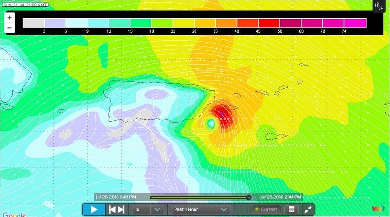
It shows 97L striking P.R. as a small tropical storm Sunday evening.
0 likes
- TheStormExpert
- Category 5
- Posts: 8487
- Age: 30
- Joined: Wed Feb 16, 2011 5:38 pm
- Location: Palm Beach Gardens, FL
Re: ATL: INVEST 97L - Models
Is that in mph or kt's?
0 likes
The following post is NOT an official forecast and should not be used as such. It is just the opinion of the poster and may or may not be backed by sound meteorological data. It is NOT endorsed by storm2k.org.
- PTrackerLA
- Category 5
- Posts: 5248
- Age: 40
- Joined: Thu Oct 10, 2002 8:40 pm
- Location: Lafayette, LA
Re: ATL: INVEST 97L - Models
Looking at the hi-res weatherbell Euro plots, you can track vorticity and the PWAT surge all the way into the gulf and into the northern Gulf coast.
0 likes
- cycloneye
- Admin
- Posts: 139517
- Age: 67
- Joined: Thu Oct 10, 2002 10:54 am
- Location: San Juan, Puerto Rico
Re: ATL: INVEST 97L - Models
0 likes
Visit the Caribbean-Central America Weather Thread where you can find at first post web cams,radars
and observations from Caribbean basin members Click Here
Re: ATL: INVEST 97L - Models
TheStormExpert wrote::uarrow: Is that in mph or kt's?
Knots! So it could be a medium strength tropical storm if the euro is correct.
0 likes
- TheStormExpert
- Category 5
- Posts: 8487
- Age: 30
- Joined: Wed Feb 16, 2011 5:38 pm
- Location: Palm Beach Gardens, FL
Re: ATL: INVEST 97L - Models
NDG wrote:TheStormExpert wrote::uarrow: Is that in mph or kt's?
Knots! So it could be a medium strength tropical storm if the euro is correct.
Thanks!
0 likes
The following post is NOT an official forecast and should not be used as such. It is just the opinion of the poster and may or may not be backed by sound meteorological data. It is NOT endorsed by storm2k.org.
Re: ATL: INVEST 97L - Models
Land interaction is going to be big. 200 miles may be the difference between pulling an Erika and staying in a fairly decent environment.
3 likes
-
- Category 1
- Posts: 267
- Age: 35
- Joined: Mon Jun 06, 2016 6:39 pm
- Location: Santa Barbara, CA
Re: ATL: INVEST 97L - Models
TheStormExpert wrote:This steering pattern seems eerily similar to last season with a stronger Bermuda High just minus the Caribbean Shear.
The similar steering pattern might be influenced by the fact that this is the transition year from el nino to la nina just without the strong shear from the el nino trade winds. The extremely active epac season so far seems to make it seem like the west coast is still under el nino conditions especially in my area in southern california where the water temp is usually cold and it still feels like tepid tap water
Last edited by Socalhurcnegirl227 on Thu Jul 28, 2016 3:03 pm, edited 1 time in total.
0 likes
"I'm a wandress, i'm a one night stand,
dont belong to no city, dont belong to no man
i'm the violence in the pouring rain,
I'm a hurricane"
dont belong to no city, dont belong to no man
i'm the violence in the pouring rain,
I'm a hurricane"
- wxman57
- Moderator-Pro Met
- Posts: 22498
- Age: 66
- Joined: Sat Jun 21, 2003 8:06 pm
- Location: Houston, TX (southwest)
Re: ATL: INVEST 97L - Discussion
Note that to reach Puerto Rico by Sunday (per GFS/Euro), the disturbance would have to travel at over 30 mph. Either it will arrive later or it will have a very hard time organizing.
3 likes
- northjaxpro
- S2K Supporter
- Posts: 8900
- Joined: Mon Sep 27, 2010 11:21 am
- Location: Jacksonville, FL
ATL: INVEST 97L - Models
Will have to wait and see the chances of development, which go up in my opinion past 5 days if the system does not have major entanglement with Hispaniola.
1 likes
NEVER, EVER SAY NEVER in the tropics and weather in general, and most importantly, with life itself!!
________________________________________________________________________________________
Fay 2008 Beryl 2012 Debby 2012 Colin 2016 Hermine 2016 Julia 2016 Matthew 2016 Irma 2017 Dorian 2019
________________________________________________________________________________________
Fay 2008 Beryl 2012 Debby 2012 Colin 2016 Hermine 2016 Julia 2016 Matthew 2016 Irma 2017 Dorian 2019
-
- Category 5
- Posts: 2422
- Joined: Sun Aug 12, 2007 3:45 am
- Location: Florida State University
Re: ATL: INVEST 97L - Models
12z Ensemble Prob % of Tropical genesis rises just east of the Leewards:
0 likes
- cycloneye
- Admin
- Posts: 139517
- Age: 67
- Joined: Thu Oct 10, 2002 10:54 am
- Location: San Juan, Puerto Rico
Re: ATL: INVEST 97L - Discussion
0 likes
Visit the Caribbean-Central America Weather Thread where you can find at first post web cams,radars
and observations from Caribbean basin members Click Here
- gatorcane
- S2K Supporter
- Posts: 23499
- Age: 46
- Joined: Sun Mar 13, 2005 3:54 pm
- Location: Boca Raton, FL
Re: ATL: INVEST 97L - Discussion
some T-storms building around center as Eric Blake points out, saved loop:
0 likes
- northjaxpro
- S2K Supporter
- Posts: 8900
- Joined: Mon Sep 27, 2010 11:21 am
- Location: Jacksonville, FL
Re: ATL: INVEST 97L - Discussion
I just think 97L in time will really have to slow down some really have a better chance to try to develop. Apparently ridging may get too strong which may steer 97L more southwest in time.
Last edited by northjaxpro on Thu Jul 28, 2016 3:35 pm, edited 1 time in total.
0 likes
NEVER, EVER SAY NEVER in the tropics and weather in general, and most importantly, with life itself!!
________________________________________________________________________________________
Fay 2008 Beryl 2012 Debby 2012 Colin 2016 Hermine 2016 Julia 2016 Matthew 2016 Irma 2017 Dorian 2019
________________________________________________________________________________________
Fay 2008 Beryl 2012 Debby 2012 Colin 2016 Hermine 2016 Julia 2016 Matthew 2016 Irma 2017 Dorian 2019
Re: ATL: INVEST 97L - Discussion
wxman57 wrote:Note that to reach Puerto Rico by Tuesday morning (per GFS/Euro), the disturbance would have to travel at over 30 mph. Either it will arrive later or it will have a very hard time organizing.
Actually the Euro has 97L arriving P.R. by Sunday evening not Tuesday morning.
1 likes
- 1900hurricane
- Category 5
- Posts: 6044
- Age: 33
- Joined: Fri Feb 06, 2015 12:04 pm
- Location: Houston, TX
- Contact:
Re: ATL: INVEST 97L - Discussion
Shear is low, but that's because deep-layer flow is 20-30 kt!
0 likes
Contract Meteorologist. TAMU & MSST. Fiercely authentic, one of a kind. We are all given free will, so choose a life meant to be lived. We are the Masters of our own Stories.
Opinions expressed are mine alone.
Follow me on Twitter at @1900hurricane : Read blogs at https://1900hurricane.wordpress.com/
Opinions expressed are mine alone.
Follow me on Twitter at @1900hurricane : Read blogs at https://1900hurricane.wordpress.com/
- cycloneye
- Admin
- Posts: 139517
- Age: 67
- Joined: Thu Oct 10, 2002 10:54 am
- Location: San Juan, Puerto Rico
Re: ATL: INVEST 97L - Discussion
0 likes
Visit the Caribbean-Central America Weather Thread where you can find at first post web cams,radars
and observations from Caribbean basin members Click Here
- wxman57
- Moderator-Pro Met
- Posts: 22498
- Age: 66
- Joined: Sat Jun 21, 2003 8:06 pm
- Location: Houston, TX (southwest)
Re: ATL: INVEST 97L - Discussion
NDG wrote:wxman57 wrote:Note that to reach Puerto Rico by Tuesday morning (per GFS/Euro), the disturbance would have to travel at over 30 mph. Either it will arrive later or it will have a very hard time organizing.
Actually the Euro has 97L arriving P.R. by Sunday evening not Tuesday morning.
Yeah, I meant Sunday. Looking at where the models (EC/GFS) initialized it, they have it way too far west to start out. They have the center at 35W in a few hours, when it's near 30W now. That won't happen. The models are probably moving it too fast. If it moves slower, the steering flow downstream may be different, perhaps allowing it to turn northward farther east.
1 likes
Who is online
Users browsing this forum: No registered users and 4 guests