ATL: ETA - Post-Tropical - Discussion
Moderator: S2k Moderators
-
PandaCitrus
- Category 1

- Posts: 424
- Joined: Mon Sep 04, 2017 2:44 pm
Re: ATL: INVEST 96L - Discussion
What is the timing on this? Any possibility this will cause a problem on election day?
1 likes
-
Hurricaneman

- Category 5

- Posts: 7404
- Age: 45
- Joined: Tue Aug 31, 2004 3:24 pm
- Location: central florida
Re: ATL: INVEST 96L - Discussion
PandaCitrus wrote:What is the timing on this? Any possibility this will cause a problem on election day?
No problem for Election day but after that is when to watch
0 likes
-
TheStormExpert
Re: ATL: INVEST 96L - Discussion
Here’s all the Tropical Storms and Hurricanes to strike Florida in November, not many!
https://twitter.com/hurricanemanwx/status/1321957921400459273
https://twitter.com/hurricanemanwx/status/1321957921400459273
1 likes
-
Nancy Smar

- Category 5
- Posts: 1081
- Age: 25
- Joined: Wed Aug 16, 2017 10:03 pm
Re: ATL: INVEST 96L - Discussion
AL, 96, 2020103000, , BEST, 0, 123N, 622W, 20, 1008, DB, 34, NEQ, 0, 0, 0, 0, 1009, 100, 90, 0, 0, L, 0, , 0, 0, INVEST, S, 0, , 0, 0, 0, 0, genesis-num, 063, SPAWNINVEST, al712020 to al962020,
2 likes
-
Blown Away

- S2K Supporter

- Posts: 10253
- Joined: Wed May 26, 2004 6:17 am
Re: ATL: INVEST 96L - Discussion
TheStormExpert wrote:Here’s all the Tropical Storms and Hurricanes to strike Florida in November, not many!
https://twitter.com/hurricanemanwx/status/1321957921400459273
If the 1935 Yankee hurricane happened again, can you imagine the chaos trying to believe the models sending a storm SW into Florida from near Bermuda.
2 likes
Hurricane Eye Experience: David 79, Irene 99, Frances 04, Jeanne 04, Wilma 05… Hurricane Brush Experience: Andrew 92, Erin 95, Floyd 99, Matthew 16, Irma 17, Ian 22, Nicole 22…
-
SFLcane

- S2K Supporter
- Posts: 10281
- Age: 48
- Joined: Sat Jun 05, 2010 1:44 pm
- Location: Lake Worth Florida
Re: ATL: INVEST 96L - Discussion
Wow this is VERY impressive. This will be a TD within 24hrs
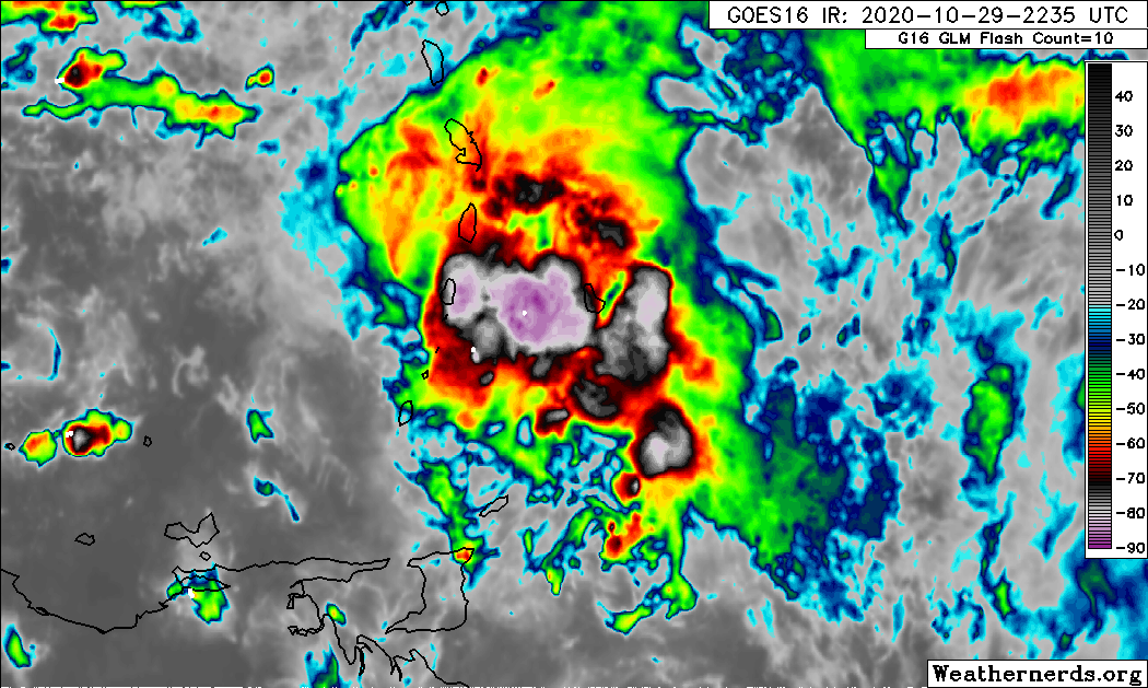
14 likes
-
ouragans

- Category 2

- Posts: 501
- Age: 54
- Joined: Sun Jun 12, 2011 12:09 pm
- Location: Abymes, Guadeloupe F.W.I
- Contact:
Re: ATL: INVEST 96L - Discussion
Nancy Smar wrote:AL, 96, 2020103000, , BEST, 0, 123N, 622W, 20, 1008, DB, 34, NEQ, 0, 0, 0, 0, 1009, 100, 90, 0, 0, L, 0, , 0, 0, INVEST, S, 0, , 0, 0, 0, 0, genesis-num, 063, SPAWNINVEST, al712020 to al962020,
12.3N 62.2W matches the current location instead of 78.0W
2 likes
Personal forecast disclaimer
This post is a personal point of view, not an information. Please refer to official statements for life-threatening decisions.
David '79, Frederic '79, Hugo '89, Iris, Luis & Marilyn '95, Georges '98, Lenny '99, Dean '07, Irma '17, Maria '17, Fiona '22, Philippe '23, Tammy '23
16°13'33.3,"6N -61°36'39.5"W
-
cycloneye

- Admin

- Posts: 149276
- Age: 69
- Joined: Thu Oct 10, 2002 10:54 am
- Location: San Juan, Puerto Rico
Re: ATL: INVEST 96L - Discussion
Nancy Smar wrote:AL, 96, 2020103000, , BEST, 0, 123N, 622W, 20, 1008, DB, 34, NEQ, 0, 0, 0, 0, 1009, 100, 90, 0, 0, L, 0, , 0, 0, INVEST, S, 0, , 0, 0, 0, 0, genesis-num, 063, SPAWNINVEST, al712020 to al962020,
Thank you for bringing the correct position one.
4 likes
Visit the Caribbean-Central America Weather Thread where you can find at first post web cams,radars
and observations from Caribbean basin members Click Here
and observations from Caribbean basin members Click Here
-
cycloneye
- Admin
- Posts: 149276
- Age: 69
- Joined: Thu Oct 10, 2002 10:54 am
- Location: San Juan, Puerto Rico
Re: ATL: INVEST 96L - Discussion
ouragans wrote:Nancy Smar wrote:AL, 96, 2020103000, , BEST, 0, 123N, 622W, 20, 1008, DB, 34, NEQ, 0, 0, 0, 0, 1009, 100, 90, 0, 0, L, 0, , 0, 0, INVEST, S, 0, , 0, 0, 0, 0, genesis-num, 063, SPAWNINVEST, al712020 to al962020,
12.3N 62.2W matches the current location instead of 78.0W
The initial one was wrong.
3 likes
Visit the Caribbean-Central America Weather Thread where you can find at first post web cams,radars
and observations from Caribbean basin members Click Here
and observations from Caribbean basin members Click Here
-
TheStormExpert
Re: ATL: INVEST 96L - Discussion
Blown Away wrote:TheStormExpert wrote:Here’s all the Tropical Storms and Hurricanes to strike Florida in November, not many!
https://twitter.com/hurricanemanwx/status/1321957921400459273
If the 1935 Yankee hurricane happened again, can you imagine the chaos trying to believe the models sending a storm SW into Florida from near Bermuda.
It’s kind of like that one run from October 16th of the GFS-P sending pre-Zeta from east to west then back east.
3 likes

Re: ATL: INVEST 96L - Discussion
GFS is showing ideal conditions for supporting a very strong TC when this gets close to Honduras.
TPW, RH, CAPE all at very high levels.
Will be in the middle of a very large anticyclone with big updraft.
They way this is developing and how it would track, could be the strongest TC of the season.
Reminds me of Wilma.
TPW, RH, CAPE all at very high levels.
Will be in the middle of a very large anticyclone with big updraft.
They way this is developing and how it would track, could be the strongest TC of the season.
Reminds me of Wilma.
4 likes
-
Keldeo1997
- Category 2
- Posts: 688
- Joined: Fri Oct 11, 2019 11:35 pm
Re: ATL: INVEST 96L - Discussion
GCANE wrote:GFS is showing ideal conditions for supporting a very strong TC when this gets close to Honduras.
TPW, RH, CAPE all at very high levels.
Will be in the middle of a very large anticyclone with big updraft.
They way this is developing and how it would track, could be the strongest TC of the season.
Reminds me of Wilma.
2020 really doesn't want to give up the CAT 5 streak lol.
2 likes
Re: ATL: INVEST 96L - Discussion
Aric Dunn wrote:wow take a look at radr out of the islands.. expect a possible TD in the next 24 hours..
https://www.rainviewer.com/map.html?loc ... &sm=0&sn=0" width="100%" frameborder="0" style="border:0;height:50vh;" allowfullscreen></iframe>
So unusual for a developing wave in that area to be moving nearly due west this time of year
3 likes
-
SconnieCane
- Category 5
- Posts: 1013
- Joined: Thu Aug 02, 2018 5:29 pm
- Location: Madison, WI
Re: ATL: INVEST 96L - Discussion
GCANE wrote:GFS is showing ideal conditions for supporting a very strong TC when this gets close to Honduras.
TPW, RH, CAPE all at very high levels.
Will be in the middle of a very large anticyclone with big updraft.
They way this is developing and how it would track, could be the strongest TC of the season.
Reminds me of Wilma.
Thought that was gonna happen with Delta but then that unexpected mid-level shear showed up. Once again, all we can say is the potential is there...
4 likes
-
SFLcane
- S2K Supporter
- Posts: 10281
- Age: 48
- Joined: Sat Jun 05, 2010 1:44 pm
- Location: Lake Worth Florida
Re: ATL: INVEST 96L - Discussion
sma10 wrote:Aric Dunn wrote:wow take a look at radr out of the islands.. expect a possible TD in the next 24 hours..
https://www.rainviewer.com/map.html?loc ... &sm=0&sn=0" width="100%" frameborder="0" style="border:0;height:50vh;" allowfullscreen></iframe>
So unusual for a developing wave in that area to be moving nearly due west this time of year
That’s that climo...
Last edited by SFLcane on Thu Oct 29, 2020 9:18 pm, edited 1 time in total.
0 likes
-
Aric Dunn
- Category 5
- Posts: 21238
- Age: 43
- Joined: Sun Sep 19, 2004 9:58 pm
- Location: Ready for the Chase.
- Contact:
Re: ATL: INVEST 96L - Discussion
sma10 wrote:Aric Dunn wrote:wow take a look at radr out of the islands.. expect a possible TD in the next 24 hours..
https://www.rainviewer.com/map.html?loc ... &sm=0&sn=0" width="100%" frameborder="0" style="border:0;height:50vh;" allowfullscreen></iframe>
So unusual for a developing wave in that area to be moving nearly due west this time of year
eastern carrib even in peak season is rare.
this has towers developing and starting wrap to the west ans SW side now.
LLC is quickly trying to develop.

4 likes
Note: If I make a post that is brief. Please refer back to previous posts for the analysis or reasoning. I do not re-write/qoute what my initial post said each time.
If there is nothing before... then just ask
Space & Atmospheric Physicist, Embry-Riddle Aeronautical University,
I believe the sky is falling...
If there is nothing before... then just ask
Space & Atmospheric Physicist, Embry-Riddle Aeronautical University,
I believe the sky is falling...
Re: ATL: INVEST 96L - Discussion
TheStormExpert wrote:Here’s all the Tropical Storms and Hurricanes to strike Florida in November, not many!
https://twitter.com/hurricanemanwx/status/1321957921400459273
Anyone around here remember 1994 Gordon? Wasn't that strong, but was a crazy zig zag of a thing
2 likes
-
SFLcane
- S2K Supporter
- Posts: 10281
- Age: 48
- Joined: Sat Jun 05, 2010 1:44 pm
- Location: Lake Worth Florida
Re: ATL: INVEST 96L - Discussion
Aric Dunn wrote:sma10 wrote:Aric Dunn wrote:wow take a look at radr out of the islands.. expect a possible TD in the next 24 hours..
https://www.rainviewer.com/map.html?loc ... &sm=0&sn=0" width="100%" frameborder="0" style="border:0;height:50vh;" allowfullscreen></iframe>
So unusual for a developing wave in that area to be moving nearly due west this time of year
eastern carrib even in peak season is rare.
this has towers developing and starting wrap to the west ans SW side now.
LLC is quickly trying to develop.
https://i.ibb.co/YccSRh3/ezgif-com-gif-maker-28.gif
This will develop way before reaching the western Caribbean.
3 likes


Re: ATL: INVEST 96L - Discussion
PandaCitrus wrote:What is the timing on this? Any possibility this will cause a problem on election day?
In my country, yes. We vote on the 11th.
6 likes
FAA ATP
Belize UAS Operator
Belize UAS Operator
-
CrazyC83
- Professional-Met

- Posts: 34315
- Joined: Tue Mar 07, 2006 11:57 pm
- Location: Deep South, for the first time!
Re: ATL: INVEST 96L - Discussion
Aric Dunn wrote:sma10 wrote:Aric Dunn wrote:wow take a look at radr out of the islands.. expect a possible TD in the next 24 hours..
https://www.rainviewer.com/map.html?loc ... &sm=0&sn=0" width="100%" frameborder="0" style="border:0;height:50vh;" allowfullscreen></iframe>
So unusual for a developing wave in that area to be moving nearly due west this time of year
eastern carrib even in peak season is rare.
this has towers developing and starting wrap to the west ans SW side now.
LLC is quickly trying to develop.
https://i.ibb.co/YccSRh3/ezgif-com-gif-maker-28.gif
Tomas 2010 developed in that area, although a bit farther east.
2 likes
Who is online
Users browsing this forum: No registered users and 130 guests