I'm most interested in this wave right now. I mention it in tonight's video:
https://www.youtube.com/watch?v=x_iZSajqk00
Central Atlantic Tropical Wave (Is Invest 96L)
Moderator: S2k Moderators
Forum rules

The posts in this forum are NOT official forecasts and should not be used as such. They are just the opinion of the poster and may or may not be backed by sound meteorological data. They are NOT endorsed by any professional institution or STORM2K. For official information, please refer to products from the National Hurricane Center and National Weather Service.
-
Hurricane Mike
- Category 2

- Posts: 675
- Joined: Tue Apr 10, 2018 7:44 am
Re: Tropical Wave inside West Africa
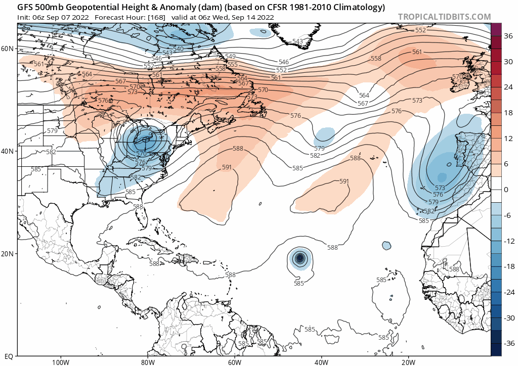
Unlike the 12Z ICON, which appeared to be setting up for a recurve way out there based on a big upper low off the CONUS, the 0Z ICON has a very different H5 setup to its NW late in the run.
0 likes
Personal Forecast Disclaimer:
The posts in this forum are NOT official forecasts and should not be used as such. They are just the opinion of the poster and may or may not be backed by sound meteorological data. They are NOT endorsed by any professional institution or storm2k.org. For official information, please refer to the NHC and NWS products.
The posts in this forum are NOT official forecasts and should not be used as such. They are just the opinion of the poster and may or may not be backed by sound meteorological data. They are NOT endorsed by any professional institution or storm2k.org. For official information, please refer to the NHC and NWS products.
-
Hurricane Mike
- Category 2
- Posts: 675
- Joined: Tue Apr 10, 2018 7:44 am
Re: Tropical Wave inside West Africa
LarryWx wrote:Unlike the 12Z ICON, which appeared to be setting up for a recurve way out there based on a big upper low off the CONUS, the 0Z ICON has a very different H5 setup to its NW late in the run.
If we wind up with four or five Cape Verde systems, one of them might break through eventually.
0 likes
Re: Tropical Wave inside West Africa
The 0Z UKMET is the 6th in a row with genesis although it develops quite a bit later than the other runs: phantom alert or just delayed development, who knows?
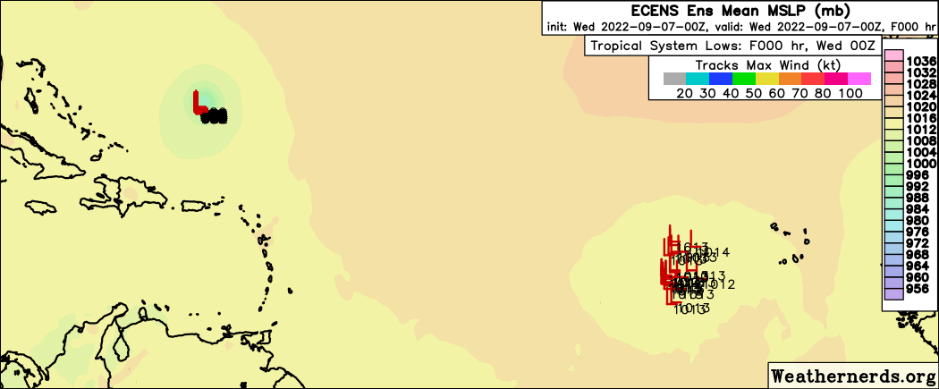
NEW TROPICAL CYCLONE FORECAST TO DEVELOP AFTER 132 HOURS
FORECAST POSITION AT T+132 : 15.7N 43.0W
LEAD CENTRAL MAXIMUM WIND
VERIFYING TIME TIME POSITION PRESSURE (MB) SPEED (KNOTS)
-------------- ---- -------- ------------- -------------
1200UTC 12.09.2022 132 15.7N 43.0W 1011 25
0000UTC 13.09.2022 144 17.7N 45.7W 1011 29
0 likes
Personal Forecast Disclaimer:
The posts in this forum are NOT official forecasts and should not be used as such. They are just the opinion of the poster and may or may not be backed by sound meteorological data. They are NOT endorsed by any professional institution or storm2k.org. For official information, please refer to the NHC and NWS products.
The posts in this forum are NOT official forecasts and should not be used as such. They are just the opinion of the poster and may or may not be backed by sound meteorological data. They are NOT endorsed by any professional institution or storm2k.org. For official information, please refer to the NHC and NWS products.

Re: Tropical Wave inside West Africa
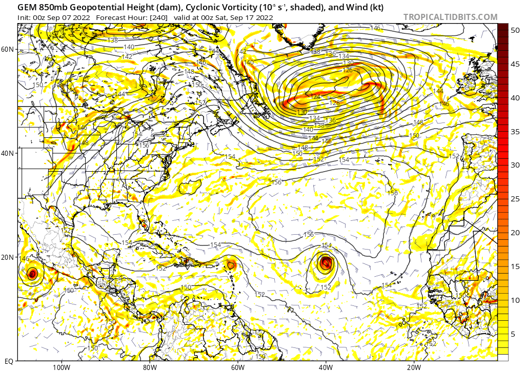
Almost all global models now agree on this wave moving W/WSW in the central to western MDR. The latest to join the party is 0z CMC, which sends it west into USVI/PR as a TD/TS.
0z GFS ends up in the same area and then crashes it into Hispaniola. Less organized than 0z CMC, but more organized than past GFS runs.
0z Euro isn't out yet, but the past Euro runs have been the strongest among the global models, albeit still only as a TS. Of course, intensity can change this far out, and so does track.
0 likes
TC naming lists: retirements and intensity
Most aggressive Advisory #1's in North Atlantic (cr. kevin for starting the list)
Most aggressive Advisory #1's in North Atlantic (cr. kevin for starting the list)
Re: Tropical Wave inside West Africa
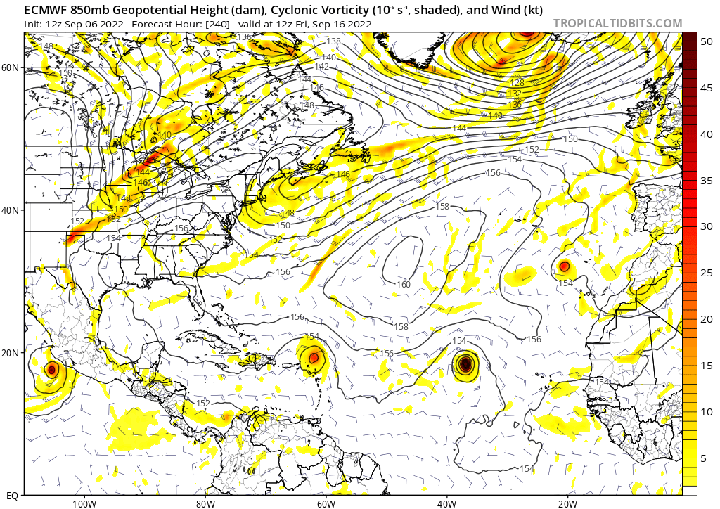
Remarkable agreement on this wave's location with 12z Euro, 0z CMC and 0z GFS 240 hours out, though it might be a coincidence:
Also, at the two EPAC storms on the GFS.
Update: LOL, 0z Euro drops development. But the track remains the same.
Also,
Update: LOL, 0z Euro drops development. But the track remains the same.
1 likes
TC naming lists: retirements and intensity
Most aggressive Advisory #1's in North Atlantic (cr. kevin for starting the list)
Most aggressive Advisory #1's in North Atlantic (cr. kevin for starting the list)
-
cycloneye

- Admin

- Posts: 149710
- Age: 69
- Joined: Thu Oct 10, 2002 10:54 am
- Location: San Juan, Puerto Rico
Re: Tropical Wave inside West Africa
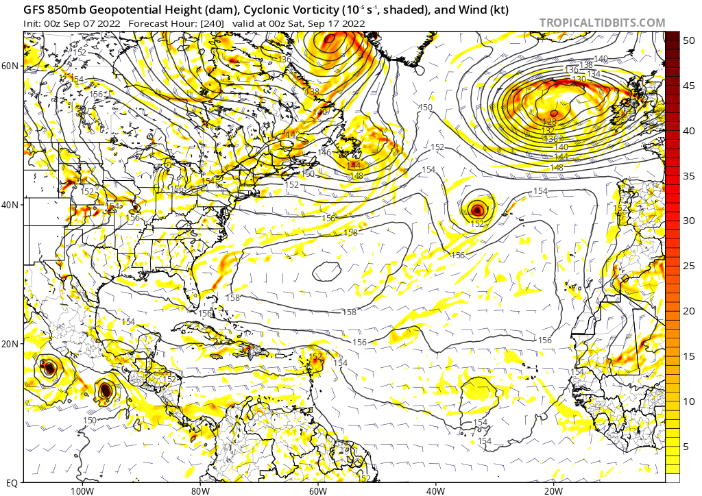
06z GFS is on board with development.
0 likes
Visit the Caribbean-Central America Weather Thread where you can find at first post web cams,radars
and observations from Caribbean basin members Click Here
and observations from Caribbean basin members Click Here
-
chris_fit

- Category 5

- Posts: 3261
- Age: 43
- Joined: Wed Sep 10, 2003 11:58 pm
- Location: Tampa Bay Area, FL
Re: Tropical Wave inside West Africa
cycloneye wrote:06z GFS is on board with development.
Indeed - Also recurves north of islands at 60W
Most 00Z EPS that due develop it also recurve.
0 likes
-
cycloneye
- Admin
- Posts: 149710
- Age: 69
- Joined: Thu Oct 10, 2002 10:54 am
- Location: San Juan, Puerto Rico
Re: Tropical Wave inside West Africa
2. African Coast:
A tropical wave currently located near the west African coast is
forecast to emerge offshore into the eastern Atlantic over the next
day or so. Environmental conditions appear conducive for some
gradual development thereafter as the system moves
west-northwestward over the eastern tropical Atlantic.
* Formation chance through 48 hours...low...near 0 percent.
* Formation chance through 5 days...low...30 percent.
0 likes
Visit the Caribbean-Central America Weather Thread where you can find at first post web cams,radars
and observations from Caribbean basin members Click Here
and observations from Caribbean basin members Click Here
-
AutoPenalti
- Category 5
- Posts: 4091
- Age: 29
- Joined: Mon Aug 17, 2015 4:16 pm
- Location: Ft. Lauderdale, Florida
Re: Tropical Wave inside West Africa
So I guess the WSW dip is gone?
0 likes
The posts in this forum are NOT official forecasts and should not be used as such. They are just the opinion of the poster and may or may not be backed by sound meteorological data. They are NOT endorsed by any professional institution or STORM2K. For official information, please refer to products from the NHC and NWS.
Model Runs Cheat Sheet:
GFS (5:30 AM/PM, 11:30 AM/PM)
HWRF, GFDL, UKMET, NAVGEM (6:30-8:00 AM/PM, 12:30-2:00 AM/PM)
ECMWF (1:45 AM/PM)
TCVN is a weighted averaged
-
Category5Kaiju

- Category 5
- Posts: 4345
- Joined: Thu Dec 24, 2020 12:45 pm
- Location: Seattle during the summer, Phoenix during the winter
Re: Tropical Wave inside West Africa
AutoPenalti wrote:So I guess the WSW dip is gone?
With these extremely long track systems in their stages of birth, it's honestly very hard to predict exactly if it'll be a solid recurve, or a recurve but very close to land, or a land threat. We saw this with storms like Irma and Florence, where OTS solutions were quite normal and expected...until they were not. Unless it's a storm like Lorenzo or Helene 2018 that just immediately recurves near the Cape Verde islands, only time will really tell with what kind of storm we end up with.
0 likes
Unless explicitly stated, all information in my posts is based on my own opinions and observations. Tropical storms and hurricanes can be extremely dangerous. Refer to an accredited weather research agency or meteorologist if you need to make serious decisions regarding an approaching storm.

Re: Tropical Wave inside West Africa
AutoPenalti wrote:So I guess the WSW dip is gone?
Technically, there is a little WSW dip this run. It just isn’t enough to get it to the islands and the storm ends up as a nice, high-ACE fish.
This is quite the abnormally aggressive GFS run for 2022. It shows the wave becoming a hurricane in just under 5 days while still east of 40W. If that were to happen, then future Fiona or Gaston would have some very high ACE potential.
1 likes
Irene '11 Sandy '12 Hermine '16 5/15/2018 Derecho Fay '20 Isaias '20 Elsa '21 Henri '21 Ida '21
I am only a meteorology enthusiast who knows a decent amount about tropical cyclones. Look to the professional mets, the NHC, or your local weather office for the best information.
I am only a meteorology enthusiast who knows a decent amount about tropical cyclones. Look to the professional mets, the NHC, or your local weather office for the best information.
-
CourierPR

- Category 5
- Posts: 1336
- Age: 72
- Joined: Tue Aug 31, 2004 7:53 pm
- Location: Pompano Beach, Florida
Re: Tropical Wave inside West Africa
chris_fit wrote:cycloneye wrote:06z GFS is on board with development.
Indeed - Also recurves north of islands at 60W
Most 00Z EPS that due develop it also recurve.
Hurricane Mike has a video showing a model that brings it into the Bahamas and close to Florida.
0 likes
-
cycloneye
- Admin
- Posts: 149710
- Age: 69
- Joined: Thu Oct 10, 2002 10:54 am
- Location: San Juan, Puerto Rico
Re: Tropical Wave inside West Africa

0 likes
Visit the Caribbean-Central America Weather Thread where you can find at first post web cams,radars
and observations from Caribbean basin members Click Here
and observations from Caribbean basin members Click Here
Re: Tropical Wave inside West Africa
This is now moving just offshore and is centered way down near 7.5N, 13W.
0 likes
Personal Forecast Disclaimer:
The posts in this forum are NOT official forecasts and should not be used as such. They are just the opinion of the poster and may or may not be backed by sound meteorological data. They are NOT endorsed by any professional institution or storm2k.org. For official information, please refer to the NHC and NWS products.
The posts in this forum are NOT official forecasts and should not be used as such. They are just the opinion of the poster and may or may not be backed by sound meteorological data. They are NOT endorsed by any professional institution or storm2k.org. For official information, please refer to the NHC and NWS products.

2022 Global Model Runs Discussion (Out thru day 16)
06z GFS has a big OTS MDR storm which could accumulate a lot of ACE, I'm talking 30 units or possibly even more.
0 likes
-
SFLcane

- S2K Supporter

- Posts: 10281
- Age: 48
- Joined: Sat Jun 05, 2010 1:44 pm
- Location: Lake Worth Florida
Re: Tropical Wave emerging from West Africa
Good luck trying to time that trof dropping down.
0 likes
-
chris_fit
- Category 5
- Posts: 3261
- Age: 43
- Joined: Wed Sep 10, 2003 11:58 pm
- Location: Tampa Bay Area, FL
Re: Tropical Wave inside West Africa
cycloneye wrote:https://i.imgur.com/9AiA6O5.gif
That's quite a bit of energy there! Let's see if it'll consolidate.
0 likes
Who is online
Users browsing this forum: emeraldislenc, Ulf and 222 guests