


ATL: SEAN - Remnants - Discussion
Moderator: S2k Moderators


Re: ATL: INVEST 92L - Discussion
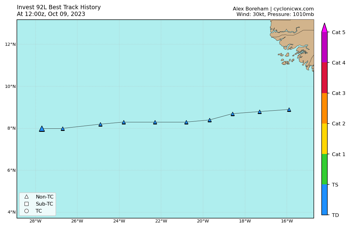
Best Track:
AL, 92, 2023100906, , BEST, 0, 82N, 249W, 25, 1010, DB
0 likes
-
Sciencerocks
- Category 5

- Posts: 10193
- Age: 40
- Joined: Thu Jul 06, 2017 1:51 am

-
cycloneye

- Admin

- Posts: 149696
- Age: 69
- Joined: Thu Oct 10, 2002 10:54 am
- Location: San Juan, Puerto Rico
Re: ATL: INVEST 92L - Discussion
AL, 92, 2023100912, , BEST, 0, 80N, 267W, 25, 1010, DB

1 likes
Visit the Caribbean-Central America Weather Thread where you can find at first post web cams,radars
and observations from Caribbean basin members Click Here
and observations from Caribbean basin members Click Here
Re: ATL: INVEST 92L - Discussion
cycloneye wrote:AL, 92, 2023100912, , BEST, 0, 80N, 267W, 25, 1010, DB
https://i.imgur.com/oq21EUt.png
The slightly south-of-west trend resumes.
0 likes
-
tolakram
- Admin
- Posts: 20186
- Age: 62
- Joined: Sun Aug 27, 2006 8:23 pm
- Location: Florence, KY (name is Mark)
Re: ATL: INVEST 92L - Discussion
What are the odds this never gets a name? Models seem to be catching up to current conditions, which appear to be quite hostile. It looks quite good, but so low. Lots of spin.
https://rammb-slider.cira.colostate.edu/?sat=goes-16&sec=full_disk&x=20028&y=9112&z=3&angle=0&im=12&ts=1&st=0&et=0&speed=130&motion=loop&maps%5Bborders%5D=white&p%5B0%5D=geocolor&opacity%5B0%5D=1&pause=0&slider=-1&hide_controls=0&mouse_draw=0&follow_feature=0&follow_hide=0&s=rammb-slider&draw_color=FFD700&draw_width=6
https://rammb-slider.cira.colostate.edu/?sat=goes-16&sec=full_disk&x=20028&y=9112&z=3&angle=0&im=12&ts=1&st=0&et=0&speed=130&motion=loop&maps%5Bborders%5D=white&p%5B0%5D=geocolor&opacity%5B0%5D=1&pause=0&slider=-1&hide_controls=0&mouse_draw=0&follow_feature=0&follow_hide=0&s=rammb-slider&draw_color=FFD700&draw_width=6
0 likes
M a r k
- - - - -
Join us in chat: Storm2K Chatroom Invite. Android and IOS apps also available.
The posts in this forum are NOT official forecasts and should not be used as such. Posts are NOT endorsed by any professional institution or STORM2K.org. For official information and forecasts, please refer to NHC and NWS products.
-
Sciencerocks
- Category 5
- Posts: 10193
- Age: 40
- Joined: Thu Jul 06, 2017 1:51 am

-
Sciencerocks
- Category 5
- Posts: 10193
- Age: 40
- Joined: Thu Jul 06, 2017 1:51 am
Re: ATL: INVEST 92L - Discussion
This is probably about 12-18 hours max from becoming a tropical cyclone. It is clearly developing inflow to the southwest quad and is looking pretty good. This will likely become a tropical storm shortly afterwards.
2 likes
-
cycloneye
- Admin
- Posts: 149696
- Age: 69
- Joined: Thu Oct 10, 2002 10:54 am
- Location: San Juan, Puerto Rico
Re: ATL: INVEST 92L - Discussion
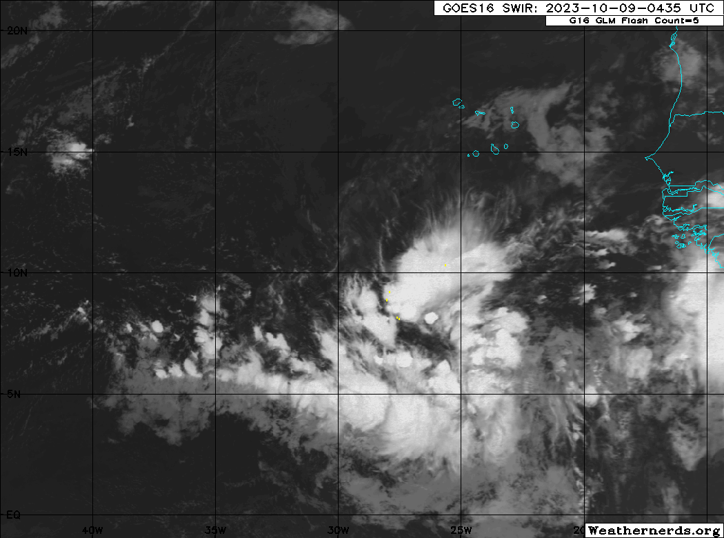
2 PM:
Eastern Tropical Atlantic (AL92):
A low-latitude tropical wave located several hundred miles
south-southwest of the Cabo Verde Islands continues to produce a
large area of showers and thunderstorms. This activity has become a
bit more concentrated this afternoon, and environmental conditions
appear conducive for additional development of this system during
the next several days. A tropical depression is likely to form in
the next couple of days while it moves west-northwestward or
northwestward across the eastern tropical Atlantic.
* Formation chance through 48 hours...high...70 percent.
* Formation chance through 7 days...high...80 percent.
1 likes
Visit the Caribbean-Central America Weather Thread where you can find at first post web cams,radars
and observations from Caribbean basin members Click Here
and observations from Caribbean basin members Click Here
Re: ATL: INVEST 92L - Discussion
Best Track:
The time stamp is 12z but the image includes the 18z plot.
AL, 92, 2023100918, , BEST, 0, 80N, 277W, 30, 1010, DB
The time stamp is 12z but the image includes the 18z plot.
1 likes
-
ElectricStorm

- Category 5
- Posts: 5153
- Age: 25
- Joined: Tue Aug 13, 2019 11:23 pm
- Location: Norman, OK
Re: ATL: INVEST 92L - Discussion
Looks can be deceiving of course but it's starting to look like a TD now
1 likes
B.S Meteorology, University of Oklahoma '25
Please refer to the NHC, NWS, or SPC for official information.
Please refer to the NHC, NWS, or SPC for official information.
-
MarioProtVI
- Category 5
- Posts: 1039
- Age: 24
- Joined: Sun Sep 29, 2019 7:33 pm
- Location: New Jersey
Re: ATL: INVEST 92L - Discussion
tolakram wrote:What are the odds this never gets a name? Models seem to be catching up to current conditions, which appear to be quite hostile. It looks quite good, but so low. Lots of spin.
https://rammb-slider.cira.colostate.edu/?sat=goes-16&sec=full_disk&x=20028&y=9112&z=3&angle=0&im=12&ts=1&st=0&et=0&speed=130&motion=loop&maps%5Bborders%5D=white&p%5B0%5D=geocolor&opacity%5B0%5D=1&pause=0&slider=-1&hide_controls=0&mouse_draw=0&follow_feature=0&follow_hide=0&s=rammb-slider&draw_color=FFD700&draw_width=6
Shear looks to be low for the next 96 hours or so. Dry air shouldn’t be a problem until it gets much more north because if it’s low latitude near the ITCZ. As one said, it’s probably undergoing TCG, and it’s quite possible we could get a brief Hurricane Sean from it too.
0 likes
-
cycloneye
- Admin
- Posts: 149696
- Age: 69
- Joined: Thu Oct 10, 2002 10:54 am
- Location: San Juan, Puerto Rico
Re: ATL: INVEST 92L - Discussion
Eastern Tropical Atlantic (AL92):
A broad area of low pressure located several hundred miles
south-southwest of the Cabo Verde Islands continues to produce a
large area of showers and thunderstorms. This activity has changed
little in organization since earlier today. However, environmental
conditions appear conducive for gradual development, and a tropical
depression is likely to form in the next couple of days while the
system moves west-northwestward or northwestward across the eastern
tropical Atlantic.
* Formation chance through 48 hours...high...70 percent.
* Formation chance through 7 days...high...80 percent.
0 likes
Visit the Caribbean-Central America Weather Thread where you can find at first post web cams,radars
and observations from Caribbean basin members Click Here
and observations from Caribbean basin members Click Here
-
cycloneye
- Admin
- Posts: 149696
- Age: 69
- Joined: Thu Oct 10, 2002 10:54 am
- Location: San Juan, Puerto Rico
Re: ATL: INVEST 92L - Discussion
AL, 92, 2023101000, , BEST, 0, 80N, 293W, 25, 1010, DB

1 likes
Visit the Caribbean-Central America Weather Thread where you can find at first post web cams,radars
and observations from Caribbean basin members Click Here
and observations from Caribbean basin members Click Here
Re: ATL: INVEST 92L - Discussion
The updated Best Track records for the last several hours shows the W to WNW to NW turn has finally begun:
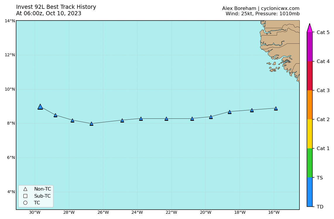
AL, 92, 2023100912, , BEST, 0, 80N, 267W, 25, 1010, DB
AL, 92, 2023100918, , BEST, 0, 82N, 278W, 25, 1010, DB
AL, 92, 2023101000, , BEST, 0, 85N, 288W, 25, 1010, DB
AL, 92, 2023101006, , BEST, 0, 90N, 297W, 25, 1010, DB
AL, 92, 2023100918, , BEST, 0, 82N, 278W, 25, 1010, DB
AL, 92, 2023101000, , BEST, 0, 85N, 288W, 25, 1010, DB
AL, 92, 2023101006, , BEST, 0, 90N, 297W, 25, 1010, DB
1 likes
-
cycloneye
- Admin
- Posts: 149696
- Age: 69
- Joined: Thu Oct 10, 2002 10:54 am
- Location: San Juan, Puerto Rico
Re: ATL: INVEST 92L - Discussion
8 AM:
Eastern Tropical Atlantic (AL92):
A broad area of low pressure located several hundred miles southwest
of the Cabo Verde Islands continues to produce a large area of
showers and thunderstorms. Environmental conditions appear conducive
for gradual development, and a tropical depression is likely to form
during the next couple of days while the system moves
west-northwestward or northwestward across the eastern tropical
Atlantic.
* Formation chance through 48 hours...high...70 percent.
* Formation chance through 7 days...high...80 percent.
0 likes
Visit the Caribbean-Central America Weather Thread where you can find at first post web cams,radars
and observations from Caribbean basin members Click Here
and observations from Caribbean basin members Click Here
-
Sciencerocks
- Category 5
- Posts: 10193
- Age: 40
- Joined: Thu Jul 06, 2017 1:51 am

-
cycloneye
- Admin
- Posts: 149696
- Age: 69
- Joined: Thu Oct 10, 2002 10:54 am
- Location: San Juan, Puerto Rico
Re: ATL: INVEST 92L - Discussion
AL, 92, 2023101012, , BEST, 0, 96N, 294W, 25, 1009, DB

1 likes
Visit the Caribbean-Central America Weather Thread where you can find at first post web cams,radars
and observations from Caribbean basin members Click Here
and observations from Caribbean basin members Click Here
-
wxman57

- Moderator-Pro Met

- Posts: 23175
- Age: 68
- Joined: Sat Jun 21, 2003 8:06 pm
- Location: Houston, TX (southwest)
Re: ATL: INVEST 92L - Discussion
Models are backing off on development now. Keeping the pressure above 1000 mb. If it does manage to become a depression, it will have a very short life.
1 likes
-
cycloneye
- Admin
- Posts: 149696
- Age: 69
- Joined: Thu Oct 10, 2002 10:54 am
- Location: San Juan, Puerto Rico
Re: ATL: INVEST 92L - Discussion
2 PM:
Eastern Tropical Atlantic (AL92):
A broad area of low pressure located several hundred miles southwest
of the Cabo Verde Islands continues to produce a large area of
showers and thunderstorms. This activity has become a bit more
concentrated while also showing signs of organization, and
environmental conditions appear conducive for additional
development. A tropical depression is likely to form during the next
couple of days while the system moves west-northwestward or
northwestward across the eastern and central tropical Atlantic.
* Formation chance through 48 hours...high...80 percent.
* Formation chance through 7 days...high...80 percent.
0 likes
Visit the Caribbean-Central America Weather Thread where you can find at first post web cams,radars
and observations from Caribbean basin members Click Here
and observations from Caribbean basin members Click Here
Who is online
Users browsing this forum: No registered users and 55 guests