ATL: Ex INVEST 99L - Discussion

Moderator: S2k Moderators

Message
Author
User avatar
weeniepatrol
Category 5
Category 5
Posts: 1307
Joined: Sat Aug 22, 2020 5:30 pm
Location: WA State

Re: ATL: INVEST 99L - Discussion (30/30)

#21 Postby weeniepatrol » Tue Aug 19, 2025 10:56 pm

zhukm29 wrote: ASCAT pass that just hit 99L:
https://i.ibb.co/DgRZHxZp/ascat-wind-99-L-202508192251.webp


Thanks! Looks very close, though perhaps not quite there yet. On satellite, it does look like southerlies are present on the eastern side.
0 likes   

User avatar
HurricaneAndre2008
Category 1
Category 1
Posts: 343
Age: 28
Joined: Wed Jul 31, 2019 9:51 pm
Contact:

Re: ATL: INVEST 99L - Discussion (30/30)

#22 Postby HurricaneAndre2008 » Tue Aug 19, 2025 11:01 pm

zhukm29 wrote: ASCAT pass that just hit 99L:
https://i.ibb.co/DgRZHxZp/ascat-wind-99-L-202508192251.webp


Looks good to me.
0 likes   
Cindy(2005), Katrina(2005), Rita(2005), Erin(2007), Isaac(2012)

User avatar
AJC3
Admin
Admin
Posts: 4060
Age: 61
Joined: Tue Aug 31, 2004 7:04 pm
Location: Ballston Spa, New York
Contact:

Re: ATL: INVEST 99L - Discussion (30/30)

#23 Postby AJC3 » Wed Aug 20, 2025 2:20 am

Tropical Weather Outlook
NWS National Hurricane Center Miami FL
200 AM EDT Wed Aug 20 2025

Eastern Tropical Atlantic (AL99):
Recent satellite-derived wind data indicate that a concentrated
area of showers and thunderstorms located just southwest of the Cabo
Verde Islands lacks a closed surface circulation. Environmental
conditions appear marginally favorable for additional development
over the next day or so while the system moves westward at around 15
mph. By the end of the week, environmental conditions are expected
to become unfavorable for further development.
* Formation chance through 48 hours...low...30 percent.
* Formation chance through 7 days...low...30 percent.
1 likes   

User avatar
abajan
S2K Supporter
S2K Supporter
Posts: 4280
Age: 61
Joined: Sun Sep 07, 2003 5:10 am
Location: Barbados

Re: ATL: INVEST 99L - Discussion (30/30)

#24 Postby abajan » Wed Aug 20, 2025 3:13 am

6Z Best Track:
AL, 99, 2025082006, , BEST, 0, 134N, 269W, 30, 1011, DB...
0 likes   

TomballEd
Category 4
Category 4
Posts: 950
Age: 61
Joined: Wed Aug 16, 2023 4:52 pm
Location: Spring/Klein area, not Tomball

Re: ATL: INVEST 99L - Discussion (30/30)

#25 Postby TomballEd » Wed Aug 20, 2025 5:18 am

No ensemble support for this near term and the remnants making a comeback in the Caribbean is far from a guaranteed thing.

It looks like it should be the mandarin but models suggest 30/30 is generous.
1 likes   

BobHarlem
Category 5
Category 5
Posts: 2427
Joined: Thu Oct 20, 2005 6:11 pm

Re: ATL: INVEST 99L - Discussion (30/30)

#26 Postby BobHarlem » Wed Aug 20, 2025 6:33 am

99L this morning. That microwave makes me think 30% is too low.

Image

Image
1 likes   

User avatar
cycloneye
Admin
Admin
Posts: 146763
Age: 69
Joined: Thu Oct 10, 2002 10:54 am
Location: San Juan, Puerto Rico

Re: ATL: INVEST 99L - Discussion (40/40)

#27 Postby cycloneye » Wed Aug 20, 2025 6:46 am

Eastern Tropical Atlantic (AL99):
A tropical wave located to the southwest of the Cabo Verde Islands
continues to produce a concentrated area of showers and
thunderstorms. Environmental conditions appear marginally favorable
for additional development over the next day or so while the system
moves westward at around 15 mph and a short-lived tropical
depression could form. By the end of the week, environmental
conditions are expected to become unfavorable for further
development.
* Formation chance through 48 hours...medium..40 percent.
* Formation chance through 7 days...medium...40 percent.
0 likes   
Visit the Caribbean-Central America Weather Thread where you can find at first post web cams,radars
and observations from Caribbean basin members Click Here

TomballEd
Category 4
Category 4
Posts: 950
Age: 61
Joined: Wed Aug 16, 2023 4:52 pm
Location: Spring/Klein area, not Tomball

Re: ATL: INVEST 99L - Discussion (40/40)

#28 Postby TomballEd » Wed Aug 20, 2025 7:48 am

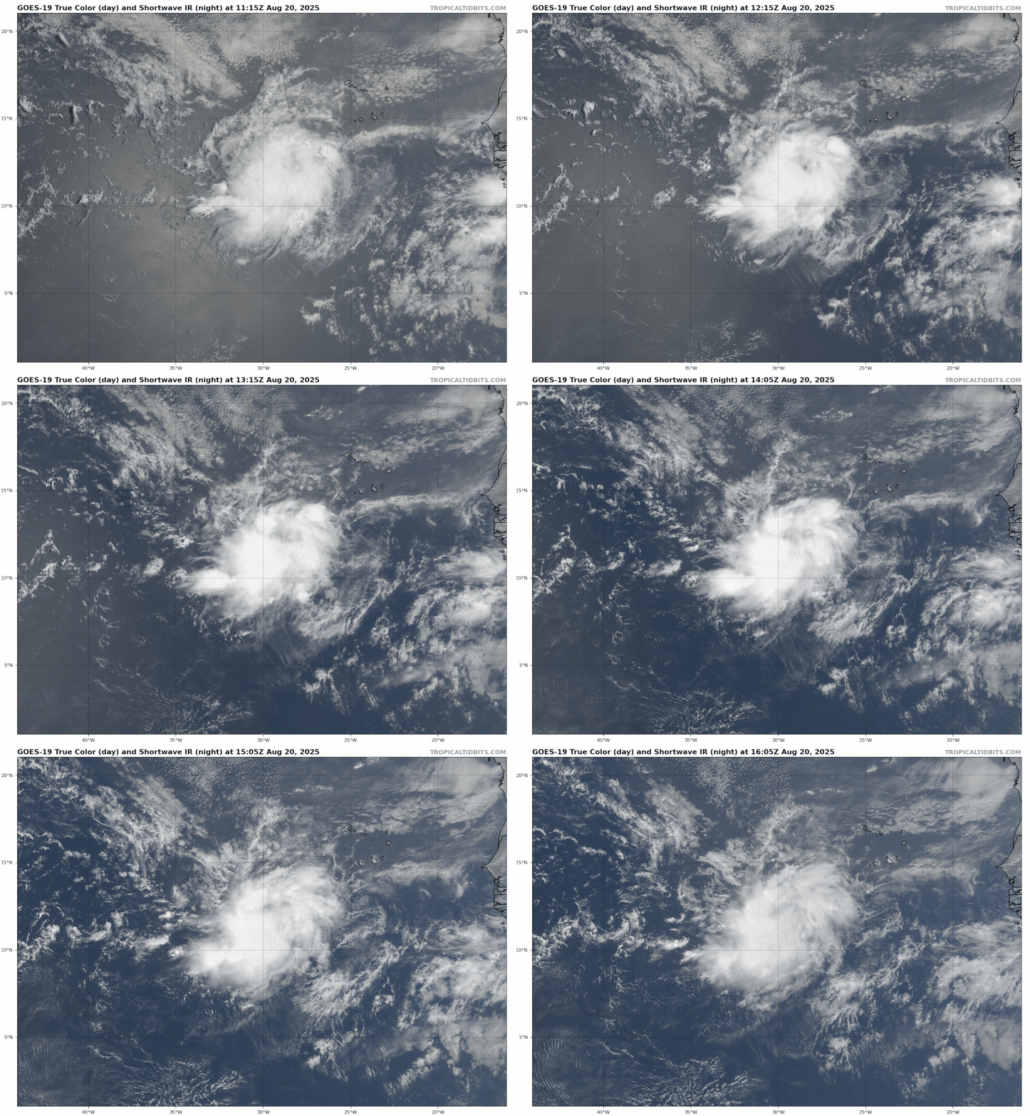
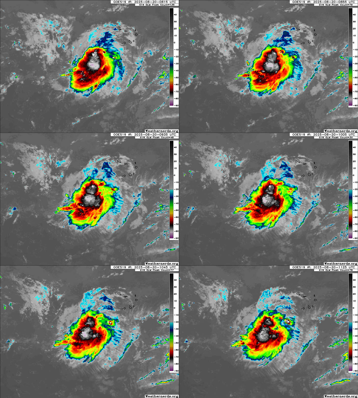
It may be short lived but it looks like a TC on the Navy Monterey image posted and visible satellite. The center is covered by storms so I can't tell for certain if there is a closed low, but I suspect there is. Has a day and a half if GFS is guide before getting murdered by shear.

A couple of lows which may or may not be developing from what is left of 99L in the SW Caribbean in 12 days on 6Z GEFS but I'm leaning against 99L being anything after its quick promotion to depression or storm.
0 likes   

User avatar
Kingarabian
S2K Supporter
S2K Supporter
Posts: 16209
Joined: Sat Aug 08, 2009 3:06 am
Location: Honolulu, Hawaii

Re: ATL: INVEST 99L - Discussion (40/40)

#29 Postby Kingarabian » Wed Aug 20, 2025 8:33 am

Likely been a TC for the past 24 hours. Has maintained convection. Has a closed center.
4 likes   
RIP Kobe Bryant

User avatar
cycloneye
Admin
Admin
Posts: 146763
Age: 69
Joined: Thu Oct 10, 2002 10:54 am
Location: San Juan, Puerto Rico

Re: ATL: INVEST 99L - Discussion (40/40)

#30 Postby cycloneye » Wed Aug 20, 2025 8:38 am

AL, 99, 2025082012, , BEST, 0, 115N, 291W, 30, 1011, DB


Image
0 likes   
Visit the Caribbean-Central America Weather Thread where you can find at first post web cams,radars
and observations from Caribbean basin members Click Here

zhukm29
Category 1
Category 1
Posts: 306
Joined: Tue Aug 28, 2018 2:37 pm

Re: ATL: INVEST 99L - Discussion (30/30)

#31 Postby zhukm29 » Wed Aug 20, 2025 8:56 am

ASCAT shows closed, with max detected winds of 34.5kt. I think this may be enough for designation. That microwave a few posts earlier is quite telling.

Image
Image
3 likes   

Powellrm
Tropical Storm
Tropical Storm
Posts: 108
Joined: Sun Sep 03, 2017 1:40 pm

Re: ATL: INVEST 99L - Discussion (40/40)

#32 Postby Powellrm » Wed Aug 20, 2025 10:31 am

Whoa I had not been keeping my eyes on this one, it would appear to be getting its act together. Impressively.
1 likes   

User avatar
cycloneye
Admin
Admin
Posts: 146763
Age: 69
Joined: Thu Oct 10, 2002 10:54 am
Location: San Juan, Puerto Rico

Re: ATL: INVEST 99L - Discussion (40/40)

#33 Postby cycloneye » Wed Aug 20, 2025 10:49 am

Image
4 likes   
Visit the Caribbean-Central America Weather Thread where you can find at first post web cams,radars
and observations from Caribbean basin members Click Here

User avatar
Kingarabian
S2K Supporter
S2K Supporter
Posts: 16209
Joined: Sat Aug 08, 2009 3:06 am
Location: Honolulu, Hawaii

Re: ATL: INVEST 99L - Discussion (40/40)

#34 Postby Kingarabian » Wed Aug 20, 2025 10:55 am

Not sure whats the hold up to be honest. Setting up dual banding features on visible.
3 likes   
RIP Kobe Bryant

User avatar
Teban54
Category 5
Category 5
Posts: 3346
Joined: Sat May 19, 2018 1:19 pm

Re: ATL: INVEST 99L - Discussion (40/40)

#35 Postby Teban54 » Wed Aug 20, 2025 11:18 am

Image
1 likes   

zhukm29
Category 1
Category 1
Posts: 306
Joined: Tue Aug 28, 2018 2:37 pm

Re: ATL: INVEST 99L - Discussion (40/40)

#36 Postby zhukm29 » Wed Aug 20, 2025 11:31 am

I think 99L looks better than Erin did when it was first designated off the African coast. Only difference is that models don’t think it will last long and will run into unfavorable conditions tomorrow so any designation will need to be done today. We’ll see what happens, but I do hope this ends up being recorded as a TC even if it’ll end up as a short-lived system.
1 likes   

zzzh
Category 3
Category 3
Posts: 894
Joined: Thu Sep 02, 2021 1:13 pm

Re: ATL: INVEST 99L - Discussion (40/40)

#37 Postby zzzh » Wed Aug 20, 2025 12:21 pm

0 likes   

User avatar
South Texas Storms
Professional-Met
Professional-Met
Posts: 4240
Joined: Thu Jun 24, 2010 12:28 am
Location: Houston, TX

Re: ATL: INVEST 99L - Discussion (40/40)

#38 Postby South Texas Storms » Wed Aug 20, 2025 12:39 pm

Still at 40% by NHC at 1pm CDT.

Eastern Tropical Atlantic (AL99):
Satellite-derived surface wind data from earlier today revealed that
a concentrated area of showers and thunderstorms located several
hundred miles southwest of the Cabo Verde Islands lacks a closed
surface circulation. Environmental conditions appear marginally
favorable for additional development over the next day or so while
the system moves west-southwestward at around 15 mph and a
short-lived tropical depression could form. By the end of the
week, environmental conditions are expected to become unfavorable
for further development.
* Formation chance through 48 hours...medium...40 percent.
* Formation chance through 7 days...medium...40 percent.
0 likes   

AutoPenalti
Category 5
Category 5
Posts: 4072
Age: 29
Joined: Mon Aug 17, 2015 4:16 pm
Location: Ft. Lauderdale, Florida

Re: ATL: INVEST 99L - Discussion (40/40)

#39 Postby AutoPenalti » Wed Aug 20, 2025 12:53 pm

I don't think there's a point in wasting a designation for a system that:

1) models aren't showing
2) feature that will likely dissipate after a couple of days

post-season they'll probably upgrade it

(watch this system bite me in the ass right after i post this)
3 likes   
The posts in this forum are NOT official forecasts and should not be used as such. They are just the opinion of the poster and may or may not be backed by sound meteorological data. They are NOT endorsed by any professional institution or STORM2K. For official information, please refer to products from the NHC and NWS.


Model Runs Cheat Sheet:
GFS (5:30 AM/PM, 11:30 AM/PM)
HWRF, GFDL, UKMET, NAVGEM (6:30-8:00 AM/PM, 12:30-2:00 AM/PM)
ECMWF (1:45 AM/PM)

TCVN
is a weighted averaged

User avatar
ConvergenceZone
Category 5
Category 5
Posts: 5214
Joined: Fri Jul 29, 2005 1:40 am
Location: Northern California

Re: ATL: INVEST 99L - Discussion (40/40)

#40 Postby ConvergenceZone » Wed Aug 20, 2025 1:22 pm

It looks like September will be the month where we will see USA landfalling threats. I guess this is normal though since storms typically fall apart or recurve when they form in August or earlier. September will more than likely be a much different story. I just don't see us getting through the whole month of September without at least one USA mainland landfall. I would be absolutely shocked if that happened.
1 likes   


Return to “2025”

Who is online

Users browsing this forum: No registered users and 38 guests