
EPAC: NARDA - Remnants - Discussion
Moderator: S2k Moderators
-
Sciencerocks
- Category 5

- Posts: 10181
- Age: 40
- Joined: Thu Jul 06, 2017 1:51 am
-
cycloneye

- Admin

- Posts: 149275
- Age: 69
- Joined: Thu Oct 10, 2002 10:54 am
- Location: San Juan, Puerto Rico
Re: EPAC: NARDA - Tropical Storm - Discussion
BULLETIN
Tropical Storm Narda Advisory Number 2
NWS National Hurricane Center Miami FL EP142025
900 PM CST Sun Sep 21 2025
...NARDA LIKELY TO INTENSIFY WHILE REMAINING OFFSHORE OF MEXICO...
SUMMARY OF 900 PM CST...0300 UTC...INFORMATION
----------------------------------------------
LOCATION...15.3N 100.5W
ABOUT 180 MI...290 KM SSE OF ZIHUATANEJO MEXICO
MAXIMUM SUSTAINED WINDS...40 MPH...65 KM/H
PRESENT MOVEMENT...NW OR 305 DEGREES AT 10 MPH...17 KM/H
MINIMUM CENTRAL PRESSURE...1005 MB...29.68 INCHES
Tropical Storm Narda Discussion Number 2
NWS National Hurricane Center Miami FL EP142025
900 PM CST Sun Sep 21 2025
Narda hasn't become significantly better organized on satellite
images over the past several hours. Convective banding features
are not yet well defined, and the overall cloud pattern is still
somewhat elongated from east to west. The system is currently
experiencing moderate east-northeasterly shear. The current
intensity estimate is held at 35 kt which is the mean of subjective
Dvorak values from TAFB and SAB.
The motion appears to be continuing toward the northwest, or around
305/9 kt. Global models show a mid-level ridge strengthening to the
north of Narda during the next couple of days. This environmental
flow evolution should cause the cyclone to turn toward the west with
some increase in forward speed during the next 48 hours or so, which
should keep the center to the south of the southern coast of Mexico.
The official track forecast is a blend of the latest corrected and
simple consensus predictions, TVCN and HCCA. This is very similar
to the previous official forecast. Late in the forecast period, the
ridge to the north weakens, which should result in a northward turn.
Narda is expected to continue to be affected by moderate vertical
wind shear for the next several days. However, the tropical
cyclone should remain embedded in a very moist air mass and
situated over a very warm oceans through the middle of the forecast
period. The intensity model guidance is in good agreement that the
system will strengthen into a hurricane within 36-48 hours and
should continue to intensity until SSTs gradually lower later in
the week. The official intensity forecast is similar to the latest
Decay-SHIPS guidance and just slightly above the latest HCCA
prediction.
FORECAST POSITIONS AND MAX WINDS
INIT 22/0300Z 15.3N 100.5W 35 KT 40 MPH
12H 22/1200Z 15.9N 101.7W 45 KT 50 MPH
24H 23/0000Z 16.3N 103.5W 55 KT 65 MPH
36H 23/1200Z 16.5N 105.4W 65 KT 75 MPH
48H 24/0000Z 16.4N 107.5W 75 KT 85 MPH
60H 24/1200Z 16.5N 109.8W 80 KT 90 MPH
72H 25/0000Z 16.6N 112.0W 85 KT 100 MPH
96H 26/0000Z 16.9N 116.8W 85 KT 100 MPH
120H 27/0000Z 17.7N 121.5W 85 KT 100 MPH
$$
Forecaster Pasch
0 likes
Visit the Caribbean-Central America Weather Thread where you can find at first post web cams,radars
and observations from Caribbean basin members Click Here
and observations from Caribbean basin members Click Here
-
cycloneye
- Admin
- Posts: 149275
- Age: 69
- Joined: Thu Oct 10, 2002 10:54 am
- Location: San Juan, Puerto Rico
Re: EPAC: NARDA - Tropical Storm - Discussion
BULLETIN
Tropical Storm Narda Advisory Number 3
NWS National Hurricane Center Miami FL EP142025
300 AM CST Mon Sep 22 2025
...NARDA STRENGTHENS SLIGHTLY AND TURNS TOWARD THE WEST-NORTHWEST
AWAY FROM MEXICO...
SUMMARY OF 300 AM CST...0900 UTC...INFORMATION
----------------------------------------------
LOCATION...15.4N 101.5W
ABOUT 160 MI...255 KM S OF ZIHUATANEJO MEXICO
MAXIMUM SUSTAINED WINDS...45 MPH...75 KM/H
PRESENT MOVEMENT...WNW OR 290 DEGREES AT 12 MPH...19 KM/H
MINIMUM CENTRAL PRESSURE...1003 MB...29.62 INCHES
Tropical Storm Narda Discussion Number 3
NWS National Hurricane Center Miami FL EP142025
300 AM CST Mon Sep 22 2025
The satellite presentation of Narda has shown some improvement since
the previous advisory, with a well-defined curved band developing
north of the center. Subjective Dvorak estimates from TAFB and SAB
were 3.0/45 kt and 2.5/35 kt, respectively, while objective
estimates from UW-CIMSS ranged from 37 to 43 kt. A blend of these
data, along with the improved satellite appearance, supports raising
the initial intensity to 40 kt for this advisory.
Narda is moving west-northwestward, or 290 degrees, at 10 kt. A
turn toward the west is expected later today as a mid-level ridge
builds over northern Mexico. This westward motion is then forecast
to continue for the next several days as the cyclone is steered by a
strengthening ridge to its north and northwest. By late in the
period, a mid-level low over southern California is expected to
erode the eastern portion of the ridge, causing the cyclone to slow
down and turn toward the northwest around day 5. The official
forecast track has been adjusted slightly south of the previous one
to better align with the latest consensus aids, and lies between the
consensus guidance and the prior forecast.
Narda will remain embedded within a moist air mass, over very warm
waters, and in an environment of light to moderate
east-northeasterly shear during the next couple of days. These
factors should support steady strengthening, and Narda is forecast
to become a hurricane Tuesday. By around 60 hours, easterly shear
is expected to increase to 20–25 kt, which should slow the rate of
intensification. By late in the forecast period, although the shear
is forecast to relax, cooler sea surface temperatures and mid-level
humidities falling below 50 percent should result in some weakening.
The official intensity forecast remains near the upper end of the
guidance envelope, close to the previous forecast, and most closely
aligned with the SHIPS and HCCA aids.
FORECAST POSITIONS AND MAX WINDS
INIT 22/0900Z 15.4N 101.5W 40 KT 45 MPH
12H 22/1800Z 16.0N 103.0W 50 KT 60 MPH
24H 23/0600Z 16.3N 105.3W 60 KT 70 MPH
36H 23/1800Z 16.2N 107.5W 70 KT 80 MPH
48H 24/0600Z 16.2N 109.8W 80 KT 90 MPH
60H 24/1800Z 16.2N 112.3W 85 KT 100 MPH
72H 25/0600Z 16.2N 114.6W 90 KT 105 MPH
96H 26/0600Z 16.6N 119.3W 90 KT 105 MPH
120H 27/0600Z 17.8N 122.9W 80 KT 90 MPH
$$
Forecaster Jelsema (CPHC)
0 likes
Visit the Caribbean-Central America Weather Thread where you can find at first post web cams,radars
and observations from Caribbean basin members Click Here
and observations from Caribbean basin members Click Here
-
Kingarabian

- S2K Supporter

- Posts: 16348
- Joined: Sat Aug 08, 2009 3:06 am
- Location: Honolulu, Hawaii
Re: EPAC: NARDA - Tropical Storm - Discussion
Today's runs had this recurving sooner. Could put a lid on intensity. Models still showing a pronounced WSW dip.
0 likes
RIP Kobe Bryant
-
cycloneye
- Admin
- Posts: 149275
- Age: 69
- Joined: Thu Oct 10, 2002 10:54 am
- Location: San Juan, Puerto Rico
Re: EPAC: NARDA - Tropical Storm - Discussion
BULLETIN
Tropical Storm Narda Advisory Number 4
NWS National Hurricane Center Miami FL EP142025
900 AM CST Mon Sep 22 2025
...NARDA GRADUALLY STRENGTHENING...
SUMMARY OF 900 AM CST...1500 UTC...INFORMATION
----------------------------------------------
LOCATION...15.7N 102.9W
ABOUT 245 MI...395 KM SSE OF MANZANILLO MEXICO
MAXIMUM SUSTAINED WINDS...50 MPH...85 KM/H
PRESENT MOVEMENT...WNW OR 285 DEGREES AT 13 MPH...20 KM/H
MINIMUM CENTRAL PRESSURE...1000 MB...29.53 INCHES
Tropical Storm Narda Discussion Number 4
NWS National Hurricane Center Miami FL EP142025
900 AM CST Mon Sep 22 2025
Narda is slowly strengthening just off the coast of southern Mexico.
The storm has been maintaining a small area of central convection
and a larger area of thunderstorms well west-northwest of the
center. The latest satellite intensity estimates range from 35 to
55 kt, and based on that data, the initial intensity is nudged up to
45 kt. Some of the outer bands are affecting portions of the coast
of Mexico, and could result in locally heavy rains and gusty winds.
The storm is estimated to be moving west-northwestward at 11 kt. A
general westward motion, away from Mexico, is expected through the
week as the storm is primarily steered by a strong subtropical high
pressure system to its north. By the weekend, a slight turn to the
west-northwest is predicted. The models are in fair agreement, but
there are notable differences in the predicted forward speed,
especially from days 3 to 5. The NHC track forecast is a little
faster than the previous one, giving more weight to the Google Deep
Mind model.
The environmental conditions appear generally conducive for the
system to strengthen with the wind shear expected to be light to
moderate while it moves within a moist airmass over warm SSTs.
Narda is forecast to become a hurricane tomorrow and will likely
continue to strengthen over the next few days. The system is
forecast to move into a more stable environment and over cool
waters late in the week, and that should induce a gradual decay.
The NHC intensity forecast lies near the high end of the guidance,
in best agreement with the HCCA aid.
FORECAST POSITIONS AND MAX WINDS
INIT 22/1500Z 15.7N 102.9W 45 KT 50 MPH
12H 23/0000Z 16.1N 104.6W 55 KT 65 MPH
24H 23/1200Z 16.3N 106.9W 65 KT 75 MPH
36H 24/0000Z 16.2N 109.1W 75 KT 85 MPH
48H 24/1200Z 16.1N 111.5W 85 KT 100 MPH
60H 25/0000Z 16.0N 114.3W 90 KT 105 MPH
72H 25/1200Z 16.0N 116.8W 90 KT 105 MPH
96H 26/1200Z 16.5N 121.5W 85 KT 100 MPH
120H 27/1200Z 17.7N 124.8W 75 KT 85 MPH
$$
Forecaster Cangialosi
0 likes
Visit the Caribbean-Central America Weather Thread where you can find at first post web cams,radars
and observations from Caribbean basin members Click Here
and observations from Caribbean basin members Click Here
-
cycloneye
- Admin
- Posts: 149275
- Age: 69
- Joined: Thu Oct 10, 2002 10:54 am
- Location: San Juan, Puerto Rico
Re: EPAC: NARDA - Tropical Storm - Discussion
EP, 14, 2025092218, , BEST, 0, 161N, 1033W, 50, 997, TS
1 likes
Visit the Caribbean-Central America Weather Thread where you can find at first post web cams,radars
and observations from Caribbean basin members Click Here
and observations from Caribbean basin members Click Here
-
cycloneye
- Admin
- Posts: 149275
- Age: 69
- Joined: Thu Oct 10, 2002 10:54 am
- Location: San Juan, Puerto Rico
Re: EPAC: NARDA - Tropical Storm - Discussion
BULLETIN
Tropical Storm Narda Advisory Number 5
NWS National Hurricane Center Miami FL EP142025
300 PM CST Mon Sep 22 2025
...NARDA EXPECTED TO BECOME A HURRICANE ON TUESDAY...
SUMMARY OF 300 PM CST...2100 UTC...INFORMATION
----------------------------------------------
LOCATION...16.2N 103.9W
ABOUT 195 MI...315 KM S OF MANZANILLO MEXICO
MAXIMUM SUSTAINED WINDS...60 MPH...95 KM/H
PRESENT MOVEMENT...WNW OR 290 DEGREES AT 13 MPH...20 KM/H
MINIMUM CENTRAL PRESSURE...997 MB...29.44 INCHES
Tropical Storm Narda Discussion Number 5
NWS National Hurricane Center Miami FL EP142025
300 PM CST Mon Sep 22 2025
Narda continues to gradually gain strength. Visible satellite
images indicate that banding features are becoming better organized,
and there is some indication of an inner core forming. The initial
intensity is nudged up to 50 kt, based on the latest satellite
intensity estimates that range from about 40 to 55 kt. Some of the
outer rain bands are affecting portions of the coast of southern and
southwestern Mexico, and these bands could continue to graze the
coast through tonight.
The storm is moving west-northwestward at 11 kt. A general westward
motion, away from Mexico, is expected through the week as the storm
is primarily steered by a strong subtropical high pressure system to
its north. By the weekend, a slight turn to the west-northwest is
predicted when the system nears a weakness in the ridge. The models
are in fair agreement in the short term, but there is considerable
spread at days 4 and 5. The NHC track forecast is similar to the
previous one, and leans on the left side of the guidance in the long
range toward the ECMWF and Google Deep Mind models, which have been
performing well this year in the east Pacific basin.
Narda is expected to continue to steadily strengthen during the next
few days as it remains in generally conducive atmospheric conditions
of low to moderate wind shear and a moist air mass while moving over
warm SSTs. The system is forecast to become a hurricane tomorrow
and could be near major hurricane strength in a couple of days. The
storm is forecast to move into a more stable environment and over
cool waters late in the week, and that should induce a gradual
decay. The NHC intensity forecast is a little higher than the
previous one, and near the high end of the model guidance, in best
agreement with HCCA and Decay-SHIPS.
FORECAST POSITIONS AND MAX WINDS
INIT 22/2100Z 16.2N 103.9W 50 KT 60 MPH
12H 23/0600Z 16.3N 105.6W 60 KT 70 MPH
24H 23/1800Z 16.3N 107.8W 70 KT 80 MPH
36H 24/0600Z 16.3N 110.1W 80 KT 90 MPH
48H 24/1800Z 16.2N 112.7W 90 KT 105 MPH
60H 25/0600Z 16.1N 115.1W 95 KT 110 MPH
72H 25/1800Z 16.2N 117.5W 95 KT 110 MPH
96H 26/1800Z 17.0N 122.2W 90 KT 105 MPH
120H 27/1800Z 18.5N 125.0W 75 KT 85 MPH
$$
Forecaster Cangialosi
0 likes
Visit the Caribbean-Central America Weather Thread where you can find at first post web cams,radars
and observations from Caribbean basin members Click Here
and observations from Caribbean basin members Click Here
-
cycloneye
- Admin
- Posts: 149275
- Age: 69
- Joined: Thu Oct 10, 2002 10:54 am
- Location: San Juan, Puerto Rico
Re: EPAC: NARDA - Tropical Storm - Discussion
Getting closer to be a hurricane.
EP, 14, 2025092300, , BEST, 0, 159N, 1045W, 55, 993, TS
0 likes
Visit the Caribbean-Central America Weather Thread where you can find at first post web cams,radars
and observations from Caribbean basin members Click Here
and observations from Caribbean basin members Click Here
-
cycloneye
- Admin
- Posts: 149275
- Age: 69
- Joined: Thu Oct 10, 2002 10:54 am
- Location: San Juan, Puerto Rico
Re: EPAC: NARDA - Tropical Storm - Discussion
BULLETIN
Tropical Storm Narda Advisory Number 6
NWS National Hurricane Center Miami FL EP142025
900 PM CST Mon Sep 22 2025
...NARDA STRENGTHENS SOME MORE AND HEADING WESTWARD AWAY FROM
MEXICO...
SUMMARY OF 900 PM CST...0300 UTC...INFORMATION
----------------------------------------------
LOCATION...15.9N 105.1W
ABOUT 220 MI...355 KM SSW OF MANZANILLO MEXICO
MAXIMUM SUSTAINED WINDS...65 MPH...100 KM/H
PRESENT MOVEMENT...W OR 270 DEGREES AT 13 MPH...20 KM/H
MINIMUM CENTRAL PRESSURE...993 MB...29.33 INCHES
Tropical Storm Narda Discussion Number 6
NWS National Hurricane Center Miami FL EP142025
900 PM CST Mon Sep 22 2025
The satellite presentation of Narda has continued to improve since
the previous advisory, with deep convection featuring cloud tops
colder than -80C bursting over the low-level center. A recent 0034
UTC WSFM microwave image confirms the improved organization, showing
Narda beginning to develop an inner-core structure. Subjective
Dvorak estimates from TAFB and SAB were both 3.5/55 kt, while
objective estimates from UW-CIMSS ranged from 44 to 60 kt. A blend
of these data, along with the improved satellite appearance,
supports raising the initial intensity to 55 kt for this advisory.
Narda is moving due west, or 270 degrees, at 11 kt. This motion is
expected to continue for the next several days as the cyclone is
steered by a strengthening subtropical ridge to its north and
northwest. By late in the period, a mid-level low over southern
California is forecast to erode the eastern portion of the ridge,
causing the cyclone to slow down and turn northwestward around day
5. The official forecast track has been adjusted slightly south of
the previous prediction during the next couple of days to account
for the westward motion that has now begun, but it remains very
close to the prior forecast from day 3 onward. The track forecast
follows a blend of the HCCA, TVCE, and FSSE consensus aids, as well
as the Google DeepMind/NOAA Eagle AI guidance.
Narda will remain embedded within a moist air mass, over very warm
waters, and in an environment of light to moderate easterly shear
during the next couple of days. These factors should support steady
strengthening. The latest GFS- and ECMWF-based SHIPS guidance
indicates about a 50 percent probability of a 25-kt increase within
24 hours, and the intensity forecast reflects this. Narda is
expected to become a hurricane later tonight or early Tuesday and
could approach major hurricane status within a couple of days. By
late in the forecast period, however, Narda will move into an
environment with mid-level humidity below 50 percent and over waters
cooler than 26C, which should result in steady to rapid weakening by
day 5. The official intensity forecast remains near the upper end of
the guidance envelope and is most closely aligned with the SHIPS and
HCCA aids.
FORECAST POSITIONS AND MAX WINDS
INIT 23/0300Z 15.9N 105.1W 55 KT 65 MPH
12H 23/1200Z 15.9N 106.8W 70 KT 80 MPH
24H 24/0000Z 15.8N 109.1W 80 KT 90 MPH
36H 24/1200Z 15.7N 111.4W 90 KT 105 MPH
48H 25/0000Z 15.6N 113.8W 95 KT 110 MPH
60H 25/1200Z 15.7N 116.4W 95 KT 110 MPH
72H 26/0000Z 16.1N 118.9W 95 KT 110 MPH
96H 27/0000Z 17.1N 122.9W 90 KT 105 MPH
120H 28/0000Z 18.7N 125.1W 70 KT 80 MPH
$$
Forecaster Jelsema (CPHC)
0 likes
Visit the Caribbean-Central America Weather Thread where you can find at first post web cams,radars
and observations from Caribbean basin members Click Here
and observations from Caribbean basin members Click Here
-
cycloneye
- Admin
- Posts: 149275
- Age: 69
- Joined: Thu Oct 10, 2002 10:54 am
- Location: San Juan, Puerto Rico
Re: EPAC: NARDA - Tropical Storm - Discussion
BULLETIN
Tropical Storm Narda Advisory Number 7
NWS National Hurricane Center Miami FL EP142025
200 AM MST Tue Sep 23 2025
...NARDA NEARING HURRICANE STRENGTH WELL OFFSHORE THE COAST OF
SOUTHWESTERN MEXICO...
SUMMARY OF 200 AM MST...0900 UTC...INFORMATION
----------------------------------------------
LOCATION...15.7N 106.1W
ABOUT 255 MI...415 KM SSW OF MANZANILLO MEXICO
MAXIMUM SUSTAINED WINDS...70 MPH...110 KM/H
PRESENT MOVEMENT...W OR 265 DEGREES AT 13 MPH...20 KM/H
MINIMUM CENTRAL PRESSURE...990 MB...29.24 INCHES
Tropical Storm Narda Discussion Number 7
NWS National Hurricane Center Miami FL EP142025
200 AM MST Tue Sep 23 2025
Narda continues to strengthen well off the coast of southwestern
Mexico this evening, with satellite imagery showing a central dense
overcast and very cold cloud tops, colder than -80C, over the
low-level center. A 0248 UTC GPM microwave pass and a 0350 UTC
Metop-C ASCAT pass were helpful in estimating the center location,
determining the motion, and assessing the structure of the cyclone.
Subjective Dvorak estimates from TAFB and SAB were 4.0/65 kt and
3.5/55 kt, respectively, while objective estimates from UW-CIMSS
ranged from 54 to 60 kt. A blend of these data, along with the
improved satellite presentation, supports raising the initial
intensity to 60 kt for this advisory.
Narda is now estimated to be moving just south of due west, or 265
degrees, at 11 kt. A general westward motion is expected to
continue during the next few days as the cyclone is steered by a
strengthening subtropical ridge to its north and northwest. A turn
toward the northwest and a decrease in forward speed are expected by
days 4 and 5 as a mid-level low over southern California erodes the
eastern portion of the subtropical ridge. The official forecast
track has been adjusted slightly to the left of the previous
forecast during the next couple of days to account for the
south-of-due-west motion, and then slightly to the right of the
prior forecast by days 4 and 5 due to an eastward shift in the
guidance. The track forecast follows a blend of the HCCA, TVCE, and
FSSE consensus aids, as well as the Google DeepMind/NOAA Eagle AI
guidance.
Narda will remain embedded within a moist air mass, over very warm
waters, and in an environment of light to moderate easterly shear
during the next day or so. These factors should support steady
strengthening. The latest GFS- and ECMWF-based SHIPS guidance
indicates about a 30 to 40 percent probability of a 25-kt increase
within 24 hours, and the intensity forecast reflects this, with
Narda expected to become a hurricane soon. Little change in
strength is forecast between 36 and 60 hours as easterly shear
increases to around 20–25 kt, which may disrupt the cyclone enough
to prevent further intensification despite otherwise favorable
conditions. Beyond 60 hours, shear is expected to decrease, which
may allow Narda to approach major hurricane status before moving
over cooler waters and into a drier mid-level environment by day 5.
The official intensity forecast remains near the upper end of the
guidance envelope and is most closely aligned with the HCCA aid.
FORECAST POSITIONS AND MAX WINDS
INIT 23/0900Z 15.7N 106.1W 60 KT 70 MPH
12H 23/1800Z 15.5N 107.8W 75 KT 85 MPH
24H 24/0600Z 15.3N 109.8W 85 KT 100 MPH
36H 24/1800Z 15.2N 112.0W 90 KT 105 MPH
48H 25/0600Z 15.3N 114.3W 90 KT 105 MPH
60H 25/1800Z 15.6N 116.6W 90 KT 105 MPH
72H 26/0600Z 16.1N 119.0W 95 KT 110 MPH
96H 27/0600Z 17.5N 122.5W 95 KT 110 MPH
120H 28/0600Z 19.4N 123.5W 70 KT 80 MPH
$$
Forecaster Jelsema (CPHC)
0 likes
Visit the Caribbean-Central America Weather Thread where you can find at first post web cams,radars
and observations from Caribbean basin members Click Here
and observations from Caribbean basin members Click Here
-
cycloneye
- Admin
- Posts: 149275
- Age: 69
- Joined: Thu Oct 10, 2002 10:54 am
- Location: San Juan, Puerto Rico
Re: EPAC: NARDA - Tropical Storm - Discussion
Hurricane.
EP, 14, 2025092312, , BEST, 0, 158N, 1068W, 75, 981, HU
1 likes
Visit the Caribbean-Central America Weather Thread where you can find at first post web cams,radars
and observations from Caribbean basin members Click Here
and observations from Caribbean basin members Click Here
-
Kingarabian
- S2K Supporter
- Posts: 16348
- Joined: Sat Aug 08, 2009 3:06 am
- Location: Honolulu, Hawaii
-
cycloneye
- Admin
- Posts: 149275
- Age: 69
- Joined: Thu Oct 10, 2002 10:54 am
- Location: San Juan, Puerto Rico
Re: EPAC: NARDA - Hurricane - Discussion
Is moving south of due west.

0 likes
Visit the Caribbean-Central America Weather Thread where you can find at first post web cams,radars
and observations from Caribbean basin members Click Here
and observations from Caribbean basin members Click Here
-
cycloneye
- Admin
- Posts: 149275
- Age: 69
- Joined: Thu Oct 10, 2002 10:54 am
- Location: San Juan, Puerto Rico
Re: EPAC: NARDA - Hurricane - Discussion
BULLETIN
Hurricane Narda Advisory Number 8
NWS National Hurricane Center Miami FL EP142025
800 AM MST Tue Sep 23 2025
...NARDA BECOMES A HURRICANE...
...ADDITIONAL STRENGTHENING EXPECTED...
SUMMARY OF 800 AM MST...1500 UTC...INFORMATION
----------------------------------------------
LOCATION...15.8N 107.3W
ABOUT 295 MI...475 KM SW OF MANZANILLO MEXICO
MAXIMUM SUSTAINED WINDS...85 MPH...140 KM/H
PRESENT MOVEMENT...W OR 270 DEGREES AT 13 MPH...20 KM/H
MINIMUM CENTRAL PRESSURE...981 MB...28.97 INCHES
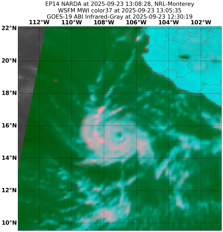
Hurricane Narda Discussion Number 8
NWS National Hurricane Center Miami FL EP142025
800 AM MST Tue Sep 23 2025
Narda has strengthened significantly overnight. Satellite images
show that deep convection has been expanding in all quadrants and
the inner core is becoming better organized. The latest satellite
intensity estimates range from 68 to 77 kt, and based on that data
and the improving cloud pattern, the initial intensity is increased
to 75 kt.
The hurricane is moving generally westward at 11 kt steered by a
strong subtropical high to its north. This high is expected to
shift westward and continue to keep Narda on a general westward
track away from Mexico during the next 2 or 3 days. After that
time, the models show a weakness developing in the ridge associated
with a cut off low moving southward over southern California. This
pattern change should cause Narda to slow down and turn
northwestward late this week and over the weekend. The NHC track
forecast is fairly similar to the previous one and closest to the
HCCA aid.
Narda is likely to continue to strengthen over the next day or so
while it remains in generally conducive atmospheric and oceanic
conditions. By late tomorrow, the models show an increase in
easterly shear and that should cause the intensity of Narda to
level off later in the week. A weakening trend should begin this
weekend when Narda is expected to track over cooler waters and into
more stable conditions. The NHC track forecast is at the top end of
the guidance in the short term, but falls close to the middle of
the guidance envelope by the end of the period.
FORECAST POSITIONS AND MAX WINDS
INIT 23/1500Z 15.8N 107.3W 75 KT 85 MPH
12H 24/0000Z 15.6N 108.9W 85 KT 100 MPH
24H 24/1200Z 15.5N 111.0W 95 KT 110 MPH
36H 25/0000Z 15.5N 113.4W 95 KT 110 MPH
48H 25/1200Z 15.7N 115.7W 95 KT 110 MPH
60H 26/0000Z 16.1N 118.1W 95 KT 110 MPH
72H 26/1200Z 16.8N 120.3W 95 KT 110 MPH
96H 27/1200Z 18.4N 123.1W 85 KT 100 MPH
120H 28/1200Z 20.3N 123.7W 65 KT 75 MPH
$$
Forecaster Cangialosi
Hurricane Narda Advisory Number 8
NWS National Hurricane Center Miami FL EP142025
800 AM MST Tue Sep 23 2025
...NARDA BECOMES A HURRICANE...
...ADDITIONAL STRENGTHENING EXPECTED...
SUMMARY OF 800 AM MST...1500 UTC...INFORMATION
----------------------------------------------
LOCATION...15.8N 107.3W
ABOUT 295 MI...475 KM SW OF MANZANILLO MEXICO
MAXIMUM SUSTAINED WINDS...85 MPH...140 KM/H
PRESENT MOVEMENT...W OR 270 DEGREES AT 13 MPH...20 KM/H
MINIMUM CENTRAL PRESSURE...981 MB...28.97 INCHES
Hurricane Narda Discussion Number 8
NWS National Hurricane Center Miami FL EP142025
800 AM MST Tue Sep 23 2025
Narda has strengthened significantly overnight. Satellite images
show that deep convection has been expanding in all quadrants and
the inner core is becoming better organized. The latest satellite
intensity estimates range from 68 to 77 kt, and based on that data
and the improving cloud pattern, the initial intensity is increased
to 75 kt.
The hurricane is moving generally westward at 11 kt steered by a
strong subtropical high to its north. This high is expected to
shift westward and continue to keep Narda on a general westward
track away from Mexico during the next 2 or 3 days. After that
time, the models show a weakness developing in the ridge associated
with a cut off low moving southward over southern California. This
pattern change should cause Narda to slow down and turn
northwestward late this week and over the weekend. The NHC track
forecast is fairly similar to the previous one and closest to the
HCCA aid.
Narda is likely to continue to strengthen over the next day or so
while it remains in generally conducive atmospheric and oceanic
conditions. By late tomorrow, the models show an increase in
easterly shear and that should cause the intensity of Narda to
level off later in the week. A weakening trend should begin this
weekend when Narda is expected to track over cooler waters and into
more stable conditions. The NHC track forecast is at the top end of
the guidance in the short term, but falls close to the middle of
the guidance envelope by the end of the period.
FORECAST POSITIONS AND MAX WINDS
INIT 23/1500Z 15.8N 107.3W 75 KT 85 MPH
12H 24/0000Z 15.6N 108.9W 85 KT 100 MPH
24H 24/1200Z 15.5N 111.0W 95 KT 110 MPH
36H 25/0000Z 15.5N 113.4W 95 KT 110 MPH
48H 25/1200Z 15.7N 115.7W 95 KT 110 MPH
60H 26/0000Z 16.1N 118.1W 95 KT 110 MPH
72H 26/1200Z 16.8N 120.3W 95 KT 110 MPH
96H 27/1200Z 18.4N 123.1W 85 KT 100 MPH
120H 28/1200Z 20.3N 123.7W 65 KT 75 MPH
$$
Forecaster Cangialosi
0 likes
Visit the Caribbean-Central America Weather Thread where you can find at first post web cams,radars
and observations from Caribbean basin members Click Here
and observations from Caribbean basin members Click Here
-
Kingarabian
- S2K Supporter
- Posts: 16348
- Joined: Sat Aug 08, 2009 3:06 am
- Location: Honolulu, Hawaii


Re: EPAC: NARDA - Hurricane - Discussion
Think this will peak as a solid cat 4, possibly cat 5 if timing is right.
2 likes
The above post and any post by Ntxw is NOT an official forecast and should not be used as such. It is just the opinion of the poster and may or may not be backed by sound meteorological data. It is NOT endorsed by any professional institution including Storm2k. For official information, please refer to NWS products.
Help support Storm2K!

-
ElectricStorm

- Category 5
- Posts: 5139
- Age: 25
- Joined: Tue Aug 13, 2019 11:23 pm
- Location: Norman, OK
Re: EPAC: NARDA - Hurricane - Discussion
Surprised NHC only went with a 95kt peak on the latest advisory, looks well on its way to becoming a major. New towers firing now
1 likes
B.S Meteorology, University of Oklahoma '25
Please refer to the NHC, NWS, or SPC for official information.
Please refer to the NHC, NWS, or SPC for official information.
-
Hurricane2022

- Category 5
- Posts: 2016
- Joined: Tue Aug 23, 2022 11:38 pm
- Location: Araçatuba, Brazil
Re: EPAC: NARDA - Hurricane - Discussion
I'm having strong Jova vibes now. I hope we can see something similar and the NHC not being too conservative again.
1 likes
Sorry for the bad English sometimes...!
For reliable and detailed information for any meteorological phenomenon, please consult the National Hurricane Center, Joint Typhoon Warning Center , or your local Meteo Center.
--------
ECCE OMNIA NOVA FACIAM (Ap 21,5).
For reliable and detailed information for any meteorological phenomenon, please consult the National Hurricane Center, Joint Typhoon Warning Center , or your local Meteo Center.
--------
ECCE OMNIA NOVA FACIAM (Ap 21,5).
Re: EPAC: NARDA - Hurricane - Discussion
Hurricane2022 wrote:I'm having strong Jova vibes now. I hope we can see something similar and the NHC not being too conservative again.
About a similar location. Given 2023 there was a strong El Nino.
1 likes
The above post and any post by Ntxw is NOT an official forecast and should not be used as such. It is just the opinion of the poster and may or may not be backed by sound meteorological data. It is NOT endorsed by any professional institution including Storm2k. For official information, please refer to NWS products.
Help support Storm2K!
Help support Storm2K!
-
Kingarabian
- S2K Supporter
- Posts: 16348
- Joined: Sat Aug 08, 2009 3:06 am
- Location: Honolulu, Hawaii
Who is online
Users browsing this forum: No registered users and 35 guests