Usually points for THE CHARLEY BOX are:
1. Storms moving north or northeast.
2. Storms that intensify atleast 15+ mph
Introducing the Charley Box....
Moderator: S2k Moderators
Forum rules

The posts in this forum are NOT official forecasts and should not be used as such. They are just the opinion of the poster and may or may not be backed by sound meteorological data. They are NOT endorsed by any professional institution or STORM2K. For official information, please refer to products from the National Hurricane Center and National Weather Service.
-
Derek Ortt
-
Stormsfury

- Category 5

- Posts: 10549
- Age: 53
- Joined: Wed Feb 05, 2003 6:27 pm
- Location: Summerville, SC
~Floydbuster wrote:Stormsfury wrote:Storms entering the GOM from the Caribbean are going to hit land about 99% of the time ... and generally a storm coming into the GOM in between the Yucatan Channel and Cuba moving S to N are going to impact Florida ...
That has nothing to do with the Charley box.
Hmm .. ok, you're going with storms intensifying within "your Charley box" ... well, it works b/c with favorable regime patterns, especially after a storm crosses Western Cuba, and is back over open water, where SST's and oceanic heat content is quite high, this would apply well with storms exiting W Cuba. Same would go for the Labor Day Hurricane ...
Part of this applies that during most of the Tropical Atlantic Season, storms can intensify quite rapidly b/c from an average, storms reaching that area, conditions are generally going to be favorable ...
1) troughs during the heart of the season do not penetrate that far south on average
2) conversely to #1, the area is generally donimated by a subtropical ridge aloft ...
3) high oceanic heat content
4) SST's are almost always near 30ºC during the heart of the season
5) part of your area outlined lies where the Gulf Stream begins
0 likes
-
Anonymous
You know Derek, I havent seen anything but the NHC report which satses:
The best-track wind speed of 60 knots at 1200 UTC is a compromise between these observations and represents an estimate of the strongest sustained winds that occurred on the southwest Florida coast. There is an uncertainty associated with official surface wind speed estimates and it is possible that Gabrielle was briefly a hurricane while making landfall. Inland winds ranged from 35-45 knots as the storm moved northeastward across Florida. A few tornados were reported from Brevard and Volusia Counties in northeast Florida.
The strengthening to 70 knots on the 17th is based on aircraft dropsonde and flight-level wind speeds. The maximum flight-level wind speed was 85 knots at 850 mb at about 1700 UTC. The standard reduction to the surface under deep convection is 90 percent, which yields a 77-knot surface wind. A few hours earlier, a GPS-dropsonde indicated a surface wind speed of 60 knots.
I do not think Gabrielle was a hurricane:
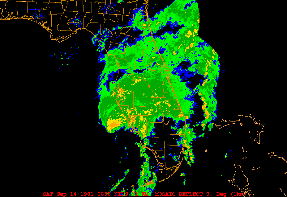
I do, however, believe "Barry" of 2001 was a hurricane. Infact I think Barry reached 80 mph that morning at this time:
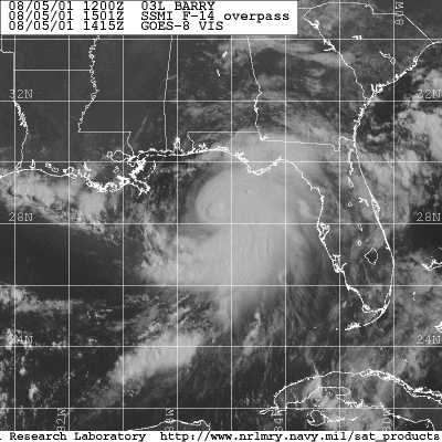
I then think it weakened back down to 70 mph:
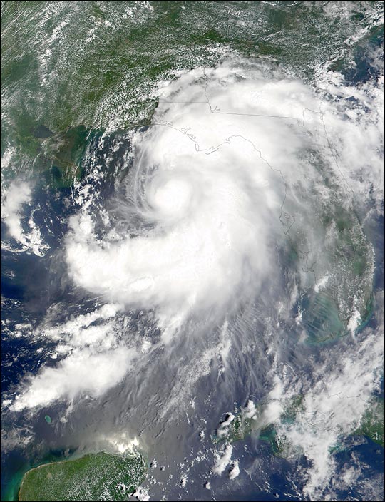
And then I think it became a 75 mph hurricane again at landfall:

I have a rare Storm Floater loop image I found that I had saved to disk back on the date Barry made landfall...

The best-track wind speed of 60 knots at 1200 UTC is a compromise between these observations and represents an estimate of the strongest sustained winds that occurred on the southwest Florida coast. There is an uncertainty associated with official surface wind speed estimates and it is possible that Gabrielle was briefly a hurricane while making landfall. Inland winds ranged from 35-45 knots as the storm moved northeastward across Florida. A few tornados were reported from Brevard and Volusia Counties in northeast Florida.
The strengthening to 70 knots on the 17th is based on aircraft dropsonde and flight-level wind speeds. The maximum flight-level wind speed was 85 knots at 850 mb at about 1700 UTC. The standard reduction to the surface under deep convection is 90 percent, which yields a 77-knot surface wind. A few hours earlier, a GPS-dropsonde indicated a surface wind speed of 60 knots.
I do not think Gabrielle was a hurricane:
I do, however, believe "Barry" of 2001 was a hurricane. Infact I think Barry reached 80 mph that morning at this time:
I then think it weakened back down to 70 mph:
And then I think it became a 75 mph hurricane again at landfall:
I have a rare Storm Floater loop image I found that I had saved to disk back on the date Barry made landfall...
0 likes
-
Wnghs2007

- Category 5
- Posts: 6836
- Age: 36
- Joined: Wed Mar 24, 2004 11:14 pm
- Location: Gwinnett-Barrow Line; Georgia
- Contact:
~Floydbuster wrote:You know Derek, I havent seen anything but the NHC report which satses:
The best-track wind speed of 60 knots at 1200 UTC is a compromise between these observations and represents an estimate of the strongest sustained winds that occurred on the southwest Florida coast. There is an uncertainty associated with official surface wind speed estimates and it is possible that Gabrielle was briefly a hurricane while making landfall. Inland winds ranged from 35-45 knots as the storm moved northeastward across Florida. A few tornados were reported from Brevard and Volusia Counties in northeast Florida.
The strengthening to 70 knots on the 17th is based on aircraft dropsonde and flight-level wind speeds. The maximum flight-level wind speed was 85 knots at 850 mb at about 1700 UTC. The standard reduction to the surface under deep convection is 90 percent, which yields a 77-knot surface wind. A few hours earlier, a GPS-dropsonde indicated a surface wind speed of 60 knots.
I do not think Gabrielle was a hurricane:
I do, however, believe "Barry" of 2001 was a hurricane. Infact I think Barry reached 80 mph that morning at this time:
I then think it weakened back down to 70 mph:
And then I think it became a 75 mph hurricane again at landfall:
I have a rare Storm Floater loop image I found that I had saved to disk back on the date Barry made landfall...
Thanks ~Floydbuster. Nice Images.
0 likes
-
HalloweenGale

- Category 1

- Posts: 377
- Joined: Sun Aug 01, 2004 7:31 pm
- Location: Nantucket Ma
- Contact:
-
Derek Ortt
Barry likely briefly reached hurricane intensity at 1400 UTC that morning at 65KT; however, sat, radar, and surface observations from landfall were consistent with a tropical storm at the coast.
Gabrielle may have been a hurricane, though at 65KT. To get a TS intensity, one has to use a surface reduction of about 65-70 percent, when the proper reduction for that level is 90 percent. Winds in Gabrielle based upon recon were in the 70-75KT range, but probably in a very narrow portion of the storm
Gabrielle may have been a hurricane, though at 65KT. To get a TS intensity, one has to use a surface reduction of about 65-70 percent, when the proper reduction for that level is 90 percent. Winds in Gabrielle based upon recon were in the 70-75KT range, but probably in a very narrow portion of the storm
0 likes
Gabrielle was pretty strong considering it only reached 55mph sustained here. But it was blowing good overnight here that night.
That storm started from a Low that lingered over the west coast of Florida right after the 9-11 attack. I knew it was going to form. Sure enough it pulled off the coast and out towards Yucatan then reversed in its tracks and started forming. It never broke out an eye so I wasn't sure if it was coming for us. It turned about 45 miles west of us and headed into Venice. It had the ingredients, just didn't have enough time over water...
Donna was worse than Charley in some ways. It had an 18 foot surge over Ft Myers Beach...
0 likes