ATL: MINDY - Post-Tropical - Discussion
Moderator: S2k Moderators
- wxman57
- Moderator-Pro Met

- Posts: 23175
- Age: 68
- Joined: Sat Jun 21, 2003 8:06 pm
- Location: Houston, TX (southwest)
Re: ATL: INVEST 91L - Discussion
16Z ASCAT indicates a squall line moving toward the FL coast. Tyndall buoy south of Apalachicola went from east at 11 kts to SW at 38 kts this hour as the squall line passed. Kind of needs a surface circulation for classification, and gusts in a squall line don't count toward a circulation, of which there is very little.


0 likes
Re: ATL: INVEST 91L - Discussion
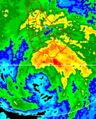
On radar it has a trackable center, which is heading toward Panama City/Mexico Beach.
0 likes
- Stormybajan
- Category 1

- Posts: 453
- Joined: Thu May 20, 2021 3:21 pm
- Location: Windward Islands
-
CrazyC83
- Professional-Met

- Posts: 34315
- Joined: Tue Mar 07, 2006 11:57 pm
- Location: Deep South, for the first time!
Re: ATL: INVEST 91L - Discussion
wx98 wrote:On radar it has a trackable center, which is heading toward Panama City/Mexico Beach.
It seems like it will slide just south of Apalachicola, which would give it more time over water?
0 likes
-
TallyTracker
- Category 2

- Posts: 787
- Joined: Thu Oct 11, 2018 2:46 pm
Re: ATL: INVEST 91L - Discussion
Is there any evidence of west winds? I haven’t seen anyone post west winds south of the center. I’m a bit skeptical this is anything more than a sharp trough.
2 likes
Fran '96, Georges '98, Gordon '00, Gabrielle '01, Charley '04, Frances '04, Jeanne '04, Barry '07, Fay '08, Debby '12, Matthew '16, Emily '17, Irma '17, Michael ‘18, Elsa ‘21, Fred ‘21, Mindy ‘21, Nicole ‘22, Idalia ‘23, Debby ‘24, Helene ‘24
Re: ATL: INVEST 91L - Discussion
TallyTracker wrote:Is there any evidence of west winds? I haven’t seen anyone post west winds south of the center. I’m a bit skeptical this is anything more than a sharp trough.
If anything I was having trouble finding east winds on the north side.
0 likes
-
grapealcoholic
- Category 2

- Posts: 703
- Joined: Tue Aug 10, 2021 3:26 pm
Re: ATL: THIRTEEN - Tropical Depression - Discussion
It has like 4-5 hours to get to TS strength. Shouldn't be too difficult
1 likes
Re: ATL: INVEST 91L - Discussion
CrazyC83 wrote:wx98 wrote:On radar it has a trackable center, which is heading toward Panama City/Mexico Beach.
It seems like it will slide just south of Apalachicola, which would give it more time over water?
It could slide south or it could come in right on the point at Apalachicola.
0 likes
Re: ATL: THIRTEEN - Tropical Depression - Discussion
Hmmm a landfalling tropical system in FL with a thread on here over a week old only has 11 pages. Talk about sneaking in the back door. 
2 likes
Re: ATL: THIRTEEN - Tropical Depression - Discussion
Looks like the went with Mindy for the advisory.
2 likes
Re: ATL: THIRTEEN - Tropical Depression - Discussion
NHC issuing advisories for the Atlantic on Hurricane Larry and TS Mindy
2 likes
-
grapealcoholic
- Category 2

- Posts: 703
- Joined: Tue Aug 10, 2021 3:26 pm
Re: ATL: THIRTEEN - Tropical Depression - Discussion
Passed over a buoy that found 45 kt gusts

Last edited by grapealcoholic on Wed Sep 08, 2021 3:58 pm, edited 1 time in total.
0 likes
- ElectricStorm
- Category 5

- Posts: 5148
- Age: 25
- Joined: Tue Aug 13, 2019 11:23 pm
- Location: Norman, OK
Re: ATL: THIRTEEN - Tropical Depression - Discussion
BULLETIN
Tropical Storm Mindy Advisory Number 1
NWS National Hurricane Center Miami FL AL132021
400 PM CDT Wed Sep 08 2021
...NEW TROPICAL STORM FORMS IN THE NORTHEAST GULF OF MEXICO...
...TROPICAL STORM WARNINGS ISSUED FOR THE FLORIDA PANHANDLE...
SUMMARY OF 400 PM CDT...2100 UTC...INFORMATION
----------------------------------------------
LOCATION...29.0N 86.3W
ABOUT 90 MI...150 KM WSW OF APALACHICOLA FLORIDA
MAXIMUM SUSTAINED WINDS...40 MPH...65 KM/H
PRESENT MOVEMENT...NE OR 50 DEGREES AT 21 MPH...33 KM/H
MINIMUM CENTRAL PRESSURE...1008 MB...29.77 INCHES
0 likes
B.S Meteorology, University of Oklahoma '25
Please refer to the NHC, NWS, or SPC for official information.
Please refer to the NHC, NWS, or SPC for official information.
-
SunnyThoughts
- Category 5

- Posts: 2263
- Joined: Wed Jul 09, 2003 12:42 pm
- Location: Pensacola, Florida
Re: ATL: THIRTEEN - Tropical Depression - Discussion
000
WTNT23 KNHC 082053
TCMAT3
TROPICAL STORM MINDY FORECAST/ADVISORY NUMBER 1
NWS NATIONAL HURRICANE CENTER MIAMI FL AL132021
2100 UTC WED SEP 08 2021
CHANGES IN WATCHES AND WARNINGS WITH THIS ADVISORY...
A TROPICAL STORM WARNING HAS BEEN ISSUED FOR THE COAST OF THE
FLORIDA PANHANDLE FROM MEXICO BEACH TO STEINHATCHEE RIVER.
SUMMARY OF WATCHES AND WARNINGS IN EFFECT...
A TROPICAL STORM WARNING IS IN EFFECT FOR...
* MEXICO BEACH TO STEINHATCHEE RIVER FLORIDA
A TROPICAL STORM WARNING MEANS THAT TROPICAL STORM CONDITIONS ARE
EXPECTED SOMEWHERE WITHIN THE WARNING AREA...IN THIS CASE IN THE
NEXT 6 TO 12 HOURS.
TROPICAL STORM CENTER LOCATED NEAR 29.0N 86.3W AT 08/2100Z
POSITION ACCURATE WITHIN 30 NM
PRESENT MOVEMENT TOWARD THE NORTHEAST OR 50 DEGREES AT 18 KT
ESTIMATED MINIMUM CENTRAL PRESSURE 1008 MB
MAX SUSTAINED WINDS 35 KT WITH GUSTS TO 45 KT.
34 KT....... 0NE 30SE 0SW 0NW.
WINDS AND SEAS VARY GREATLY IN EACH QUADRANT. RADII IN NAUTICAL
MILES ARE THE LARGEST RADII EXPECTED ANYWHERE IN THAT QUADRANT.
0 likes
-
AlphaToOmega
- Category 5

- Posts: 1448
- Joined: Sat Jun 26, 2021 10:51 am
- Location: Somewhere in Massachusetts
Re: ATL: MINDY - Tropical Storm - Discussion
This went from TD 13L to TS Mindy in a few minutes. That was the fastest upgrade I have ever seen!
5 likes
Re: ATL: MINDY - Tropical Storm - Discussion
AlphaToOmega wrote:This went from TD 13L to TS Mindy in a few minutes. That was the fastest upgrade I have ever seen!
So fast it technically wasn’t even a depression operationally
0 likes
-
Stormcenter
- S2K Supporter

- Posts: 6689
- Joined: Wed Sep 03, 2003 11:27 am
- Location: Houston, TX
Re: ATL: MINDY - Tropical Storm - Discussion
The sad thing none of multi million dollar models showed
this even becoming a TD.
this even becoming a TD.
0 likes
-
AlphaToOmega
- Category 5

- Posts: 1448
- Joined: Sat Jun 26, 2021 10:51 am
- Location: Somewhere in Massachusetts
Re: ATL: MINDY - Tropical Storm - Discussion
Stormcenter wrote:The sad thing none of multi million dollar models showed
this even becoming a TD.
A few days ago, the GFS was showing a hurricane making landfall in Florida.
0 likes
-
grapealcoholic
- Category 2

- Posts: 703
- Joined: Tue Aug 10, 2021 3:26 pm
Re: ATL: MINDY - Tropical Storm - Discussion
AlphaToOmega wrote:Stormcenter wrote:The sad thing none of multi million dollar models showed
this even becoming a TD.
A few days ago, the GFS was showing a hurricane making landfall in Florida.
It was one run, no?
0 likes
Re: ATL: MINDY - Tropical Storm - Discussion
Stormcenter wrote:The sad thing none of multi million dollar models showed
this even becoming a TD.
The past 7 GFS runs have depicted 91L developing a tight closed surface circulation, as strong as 1004-1005mb.
4 likes
Kendall -> SLO -> PBC
Memorable Storms: Katrina (for its Florida landfall...) Wilma Matthew Irma
Memorable Storms: Katrina (for its Florida landfall...) Wilma Matthew Irma
Who is online
Users browsing this forum: No registered users and 15 guests


