The center of circulation is pretty easy to identify on windy vs Sat images:
https://www.windy.com/?16.689,-84.990,6 ... ,m:eeoadQe
ATL: HELENE - Post-Tropical - Discussion
Moderator: S2k Moderators
-
Beer Belly
- Tropical Low

- Posts: 15
- Joined: Tue Sep 27, 2022 8:57 pm
-
chris_fit

- Category 5

- Posts: 3261
- Age: 43
- Joined: Wed Sep 10, 2003 11:58 pm
- Location: Tampa Bay Area, FL
Re: ATL: INVEST 97L - Discussion= 8 AM TWO= PTC at 11 AM EDT
cycloneye wrote:12z Best Track:AL, 97, 2024092312, , BEST, 0, 172N, 818W, 25, 1004, DB
Probably doesn't mean too much without a well defined center, but this is on the eastern edge of 06z guidance.

0 likes
-
Category5Kaiju

- Category 5
- Posts: 4330
- Joined: Thu Dec 24, 2020 12:45 pm
- Location: Seattle and Phoenix
Re: ATL: INVEST 97L - Discussion
Hypercane_Kyle wrote:Either outflow from TS John or displacement of the ULAC appears to be causing 97L to form more east than expected. This is why the GFS/Euro has shifted east. Tampa needs to be on alert for these trends to continue.
I do somewhat think that John may at least be playing a role in this, given it looks to be a very healthy, intensifying system. Would be interesting to hypothetically know how things for 97L may be different had John been absent.
2 likes
Unless explicitly stated, all info in my posts is based on my own opinions and observations. Tropical storms and hurricanes can be extremely dangerous. Refer to an accredited weather research agency or meteorologist if you need to make serious decisions regarding an approaching storm.

Re: ATL: INVEST 97L - Discussion= 8 AM TWO= PTC at 11 AM EDT
Wow! Well East of forecast points. Lets hope Tampas luck has not run out. NOAA flights begin this afternoon so this evenings model runs should have a good handle on track. Good luck all!
0 likes
The following post is NOT an official forecast and should not be used as such. It is just the opinion of the poster and may or may not be backed by sound meteorological data. It is NOT endorsed by any professional institution including storm2k.org For Official Information please refer to the NHC and NWS products.
-
cycloneye

- Admin

- Posts: 149267
- Age: 69
- Joined: Thu Oct 10, 2002 10:54 am
- Location: San Juan, Puerto Rico
Re: ATL: INVEST 97L - Discussion= 8 AM TWO= PTC at 11 AM EDT
cycloneye wrote:12z Best Track:AL, 97, 2024092312, , BEST, 0, 172N, 818W, 25, 1004, DB

0 likes
Visit the Caribbean-Central America Weather Thread where you can find at first post web cams,radars
and observations from Caribbean basin members Click Here
and observations from Caribbean basin members Click Here
-
Blown Away

- S2K Supporter

- Posts: 10253
- Joined: Wed May 26, 2004 6:17 am
Re: ATL: INVEST 97L - Discussion= 8 AM TWO= PTC at 11 AM EDT
cycloneye wrote:12z Best Track:AL, 97, 2024092312, , BEST, 0, 172N, 818W, 25, 1004, DB
Luis we’ve been starring at these satellite loops for decades…
1 likes
Hurricane Eye Experience: David 79, Irene 99, Frances 04, Jeanne 04, Wilma 05… Hurricane Brush Experience: Andrew 92, Erin 95, Floyd 99, Matthew 16, Irma 17, Ian 22, Nicole 22…

Re: ATL: INVEST 97L - Discussion= 8 AM TWO= PTC at 11 AM EDT
It does look to me like outflow from John is pushing 97L further east. As 97L consolidates further it should be able to withstand this better so it won't continue for long. Since models in general seem to have underestimated John and are catching up now, this could be a reason why some of the models like GFS are also shifting more east. If this hypothesis is true, than the very healthy look of John atm (healthier than even the most recent models indicated) could mean that we'll get more east shifts. On the other hand, HAFS-B seems to be the most aggressive hurricane model in terms of John in the short-term and it doesn't show a significant east bias with 97L in its most recent run. So the conclusion is, who knows.
0 likes
-
skillz305
- Category 1

- Posts: 312
- Joined: Sat Sep 08, 2018 11:10 am
- Location: Miami, Florida --> Vero Beach, Florida
Re: ATL: INVEST 97L - Discussion= 8 AM TWO= PTC at 11 AM EDT
East coast central Florida here. Just got wind of this system being alive. Watching cautiously cuz it seems east of guidance as of now IMO.
0 likes
 Hurricanes: Andrew 1992 - Irene 1999 - Frances 2004 - Jeanne 2004 - Katrina 2005 - Wilma 2005 - Matthew 2016 - Irma 2017 - Ian 2022 - Nicole 2022 - Milton 2024
Re: ATL: INVEST 97L - Discussion= 8 AM TWO= PTC at 11 AM EDT
As an OG Florida man, with ~72 hours to potential impacts, I think it would be wise for anyone in Florida to start preparing if they haven't already. I'm talking topping off your tank, checking your gensets / fuel for gensets, and getting topped off on any food and water.
All it takes is 24 more hours and a news cycle and this place will be nuts with all the newcomers to the state. I can't even imagine how wild it will be.
You don't need to be within the impact area to lose power, have flooding, etc.
All it takes is 24 more hours and a news cycle and this place will be nuts with all the newcomers to the state. I can't even imagine how wild it will be.
You don't need to be within the impact area to lose power, have flooding, etc.
4 likes
-
StPeteMike

- Category 2

- Posts: 653
- Joined: Thu Jun 07, 2018 11:26 pm
Re: ATL: INVEST 97L - Discussion= 8 AM TWO= PTC at 11 AM EDT
verruckt wrote:As an OG Florida man, with ~72 hours to potential impacts, I think it would be wise for anyone in Florida to start preparing if they haven't already. I'm talking topping off your tank, checking your gensets / fuel for gensets, and getting topped off on any food and water.
All it takes is 24 more hours and a news cycle and this place will be nuts with all the newcomers to the state. I can't even imagine how wild it will be.
You don't need to be within the impact area to lose power, have flooding, etc.
My plans during my lunch break. I saw how crazy it got with Irma, want to be ahead of the madness.
1 likes
The above post is not official and should not be used as such. It is the opinion of the poster and may or may not be backed by sound meteorological data. It is not endorsed by any professional institution or storm2k.org. For official information, please refer to the NHC and NWS products.
-
Frank P
- S2K Supporter
- Posts: 2779
- Joined: Fri Aug 29, 2003 10:52 am
- Location: Biloxi Beach, Ms
- Contact:
Re: ATL: INVEST 97L - Discussion= PTC at 11 AM EDT
The system appears to be moving wnw as best I can tell.

1 likes
-
REDHurricane

- Category 1
- Posts: 438
- Age: 28
- Joined: Sun Jul 03, 2022 2:36 pm
- Location: Northeast Pacific Ocean
Re: ATL: INVEST 97L - Discussion= PTC at 11 AM EDT
LLC getting better defined as I type and now it's starting to pull in the new convective bursts that are popping up in a shrimp-like pattern around it, this should easily be a tropical storm by the end of the day and a hurricane by the end of the day Tuesday.
2 likes
-
StormPyrate
- Category 1
- Posts: 286
- Joined: Sun May 27, 2018 8:41 pm
- Location: Clearwater, FL
Re: ATL: INVEST 97L - Discussion= PTC at 11 AM EDT
Sure seem like it is organizing well east of the stated location
3 likes
St Petersburg Florida
-
Blown Away
- S2K Supporter
- Posts: 10253
- Joined: Wed May 26, 2004 6:17 am
Re: ATL: INVEST 97L - Discussion= 8 AM TWO= PTC at 11 AM EDT
cycloneye wrote:cycloneye wrote:12z Best Track:AL, 97, 2024092312, , BEST, 0, 172N, 818W, 25, 1004, DB
https://i.imgur.com/o8mkYZ5.png
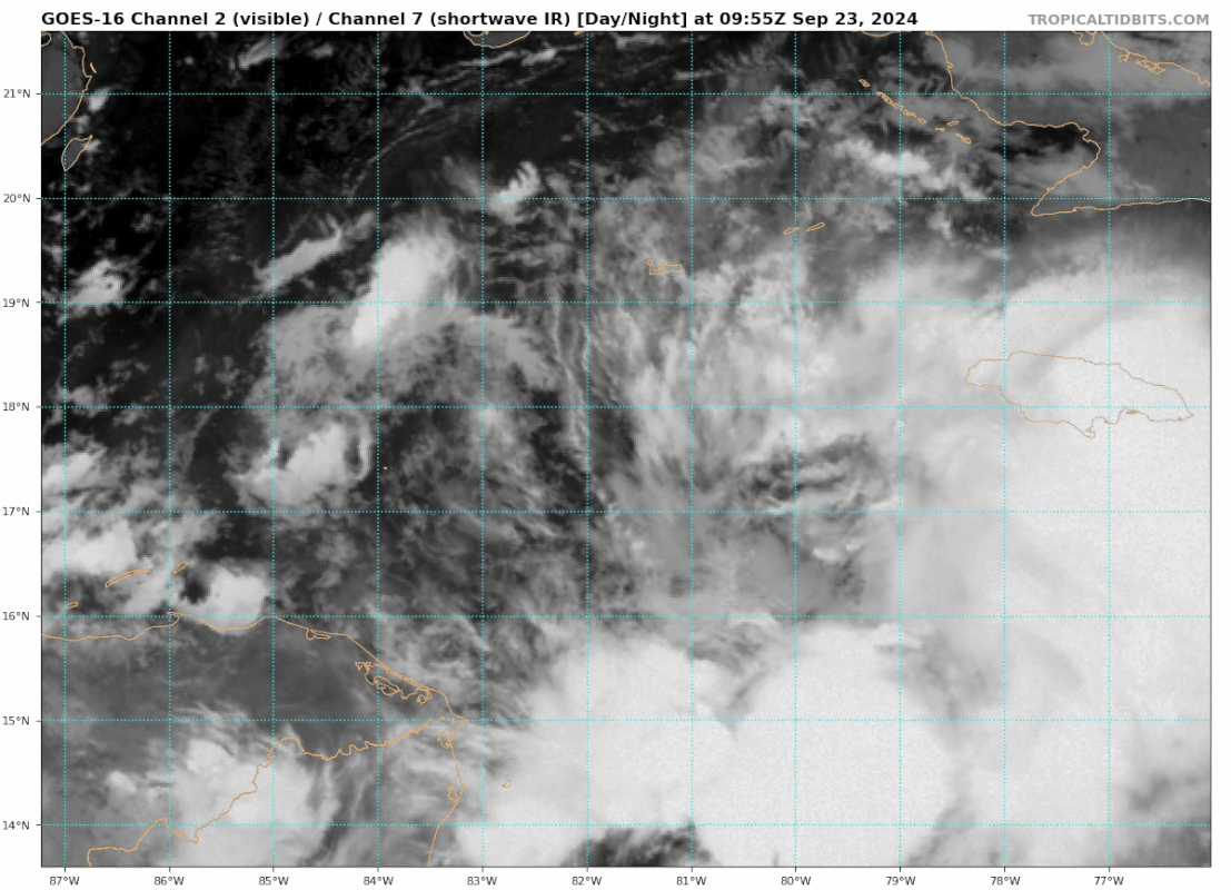
Again, IMO the LLC is a full degree ENE @17.5N/80.5…
2 likes
Hurricane Eye Experience: David 79, Irene 99, Frances 04, Jeanne 04, Wilma 05… Hurricane Brush Experience: Andrew 92, Erin 95, Floyd 99, Matthew 16, Irma 17, Ian 22, Nicole 22…
Re: ATL: INVEST 97L - Discussion= 8 AM TWO= PTC at 11 AM EDT
Beer Belly wrote:The center of circulation is pretty easy to identify on windy vs Sat images:
https://www.windy.com/?16.689,-84.990,6 ... ,m:eeoadQe
Wow, you sure can. I've used Windy before but not for this app.
2 likes
-
DunedinDave
- Category 1
- Posts: 269
- Joined: Fri Aug 25, 2023 10:31 am
Re: ATL: INVEST 97L - Discussion= PTC at 11 AM EDT
Looks to me the center is around 17.2 N and 80.8 W unless my eyes are deceiving me. I think the NHC had it at 81.8 W so it's a full degree to the east of where the NHC has it.
1 likes
-
Blown Away
- S2K Supporter
- Posts: 10253
- Joined: Wed May 26, 2004 6:17 am
Re: ATL: INVEST 97L - Discussion= PTC at 11 AM EDT
IMO Cayman going to get some 97L/PTC TS winds…
0 likes
Hurricane Eye Experience: David 79, Irene 99, Frances 04, Jeanne 04, Wilma 05… Hurricane Brush Experience: Andrew 92, Erin 95, Floyd 99, Matthew 16, Irma 17, Ian 22, Nicole 22…
-
SouthFLTropics

- Category 5
- Posts: 4258
- Age: 50
- Joined: Thu Aug 14, 2003 8:04 am
- Location: Port St. Lucie, Florida
Re: ATL: INVEST 97L - Discussion= PTC at 11 AM EDT
Blown Away wrote:IMO Cayman going to get some 97L/PTC TS winds…
Agreed... I would expect TS Warnings to go up in the Cayman Islands on the first advisory.
0 likes
Fourth Generation Florida Native
Personal Storm History: David 79, Andrew 92, Erin 95, Floyd 99, Irene 99, Frances 04, Jeanne 04, Wilma 05, Matthew 16, Irma 17, Ian 22, Nicole 22, Milton 24
Personal Storm History: David 79, Andrew 92, Erin 95, Floyd 99, Irene 99, Frances 04, Jeanne 04, Wilma 05, Matthew 16, Irma 17, Ian 22, Nicole 22, Milton 24
-
cheezyWXguy

- Category 5
- Posts: 6281
- Joined: Mon Feb 13, 2006 12:29 am
- Location: Dallas, TX
Re: ATL: INVEST 97L - Discussion= PTC at 11 AM EDT
Now that visible satellite is coming into play, I can see the area the nhc is highlighting. Hard to tell if the circulation to the east is an mlc or if it’s the main llc and the nhc area is just an eddy revolving around it. Suspecting the former for now, but wherever consistent convection maintains will likely have some influence on where this consolidates.
Last edited by cheezyWXguy on Mon Sep 23, 2024 9:01 am, edited 1 time in total.
0 likes
-
cycloneye
- Admin
- Posts: 149267
- Age: 69
- Joined: Thu Oct 10, 2002 10:54 am
- Location: San Juan, Puerto Rico
Re: ATL: INVEST 97L - Discussion= PTC at 11 AM EDT
Best Track changed to 09L. PTC comming shortly.
AL, 09, 2024092312, , BEST, 0, 172N, 818W, 25, 1004, DB, 34, NEQ, 0, 0, 0, 0, 1008, 200, 120, 0, 0, L, 0, , 0, 0, NINE,
5 likes
Visit the Caribbean-Central America Weather Thread where you can find at first post web cams,radars
and observations from Caribbean basin members Click Here
and observations from Caribbean basin members Click Here
Who is online
Users browsing this forum: No registered users and 34 guests