ATL: Tropical Depression Edouard

Moderator: S2k Moderators

Message
Author
njweather
Tropical Storm
Tropical Storm
Posts: 169
Joined: Fri Aug 17, 2007 10:45 pm
Location: Washington, DC

Re: ATL: Tropical Storm Edouard - Gulf of Mexico

#2101 Postby njweather » Mon Aug 04, 2008 6:03 pm

SouthFloridawx wrote:
Thunder44 wrote:Dr. Lyons on TWC, just said he thinks the pressure drop is partly related to the dinural pressure trend in the tropics. But he is concerned that is slowed down. It gives up more to time "spin up" before landfall.


Slowing down is all the more reason why I think it's going to head more towards LA, than Texas.


What does its speed have to with the steering mechanism?

Also, this storm will make landfall at around Dmax, correct?
0 likes   

kurtpage
Tropical Storm
Tropical Storm
Posts: 228
Joined: Tue Sep 20, 2005 11:16 pm
Location: Texas

Re:

#2102 Postby kurtpage » Mon Aug 04, 2008 6:04 pm

Aric Dunn wrote:very iteresting ........

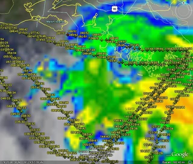
the last recon here

225800 2925N 09142W 8431 01578 0118 +158 +158 087052 053 039 000 00

53kt at 91.2N thats on the coast!! well away from the center.. north quad


Still at operational altitude as well....
0 likes   

User avatar
KWT
Category 5
Category 5
Posts: 31415
Joined: Tue Aug 17, 2004 11:02 am
Location: UK!!!

#2103 Postby KWT » Mon Aug 04, 2008 6:04 pm

Ah ok that makes a lot more sense, just north of west then is the track it seems. Still got deep convection over the center as well.

What was the speed between those two fixed by the way?
Last edited by KWT on Mon Aug 04, 2008 6:05 pm, edited 1 time in total.
0 likes   

User avatar
HURAKAN
Professional-Met
Professional-Met
Posts: 46086
Age: 38
Joined: Thu May 20, 2004 4:34 pm
Location: Key West, FL
Contact:

#2104 Postby HURAKAN » Mon Aug 04, 2008 6:05 pm

Image

Don't know if you should count when they are over land. Also, most of the obs end in 03.
0 likes   

User avatar
HURAKAN
Professional-Met
Professional-Met
Posts: 46086
Age: 38
Joined: Thu May 20, 2004 4:34 pm
Location: Key West, FL
Contact:

Re: ATL: Tropical Storm Edouard - Gulf of Mexico

#2105 Postby HURAKAN » Mon Aug 04, 2008 6:06 pm

URNT15 KNHC 042258
AF308 0305A EDOUARD1 HDOB 38 20080804
224830 2916N 09051W 8428 01581 0118 +150 +150 108045 045 999 999 03
224900 2916N 09054W 8428 01579 0115 +149 +149 111044 044 999 999 03
224930 2917N 09056W 8430 01579 0120 +149 +149 112044 045 999 999 03
225000 2917N 09059W 8428 01578 0116 +153 +153 111045 045 999 999 03
225030 2918N 09102W 8430 01567 0110 +155 +155 109044 044 999 999 03
225100 2918N 09104W 8432 01573 0114 +155 +155 105044 045 999 999 03
225130 2919N 09107W 8431 01573 0113 +155 +155 104046 047 999 999 03

225200 2920N 09110W 8429 01580 0120 +153 +153 104047 047 041 000 00
225230 2921N 09112W 8428 01581 0120 +153 +153 096047 048 036 000 00
225300 2922N 09115W 8428 01574 0117 +153 +153 092049 050 039 000 03
225330 2922N 09117W 8427 01582 0120 +154 +154 090050 050 037 000 03

225400 2922N 09120W 8430 01578 0119 +155 +155 088051 051 033 000 00
225430 2923N 09123W 8428 01579 0119 +151 +151 089051 052 038 000 03
225500 2923N 09126W 8429 01580 0120 +153 +153 090051 052 042 000 00
225530 2923N 09128W 8432 01576 0119 +150 +150 092051 051 035 000 00
225600 2924N 09131W 8427 01579 0121 +150 +150 090051 052 038 000 03
225630 2924N 09134W 8428 01580 0120 +153 +153 089051 052 035 000 00
225700 2924N 09137W 8427 01581 0120 +156 +156 086050 050 038 000 00
225730 2925N 09139W 8424 01586 0118 +159 +159 088052 052 035 000 00
225800 2925N 09142W 8431 01578 0118 +158 +158 087052 053 039 000 00
0 likes   

Aric Dunn
Category 5
Category 5
Posts: 21238
Age: 42
Joined: Sun Sep 19, 2004 9:58 pm
Location: Ready for the Chase.
Contact:

Re:

#2106 Postby Aric Dunn » Mon Aug 04, 2008 6:07 pm

HURAKAN wrote:Image

Don't know if you should count when they are over land. Also, most of the obs end in 03.


right the 03 ones were over land..
the rest and the one i posted was over water just near the coast..

the 53kts was over water.. with no 03
0 likes   

RL3AO
Moderator-Pro Met
Moderator-Pro Met
Posts: 16308
Joined: Thu Jun 14, 2007 10:03 pm
Location: NC

#2107 Postby RL3AO » Mon Aug 04, 2008 6:08 pm

03 means SFMR is questionable. FL winds questionable is 02.
0 likes   

User avatar
Ivanhater
Storm2k Moderator
Storm2k Moderator
Posts: 11162
Age: 38
Joined: Fri Jul 01, 2005 8:25 am
Location: Pensacola

Re: ATL: Tropical Storm Edouard - Gulf of Mexico

#2108 Postby Ivanhater » Mon Aug 04, 2008 6:09 pm

njweather wrote:
SouthFloridawx wrote:
Thunder44 wrote:Dr. Lyons on TWC, just said he thinks the pressure drop is partly related to the dinural pressure trend in the tropics. But he is concerned that is slowed down. It gives up more to time "spin up" before landfall.


Slowing down is all the more reason why I think it's going to head more towards LA, than Texas.


What does its speed have to with the steering mechanism?

Also, this storm will make landfall at around Dmax, correct?


If he is slowing, it is indicative of a weaker high to his north which would allow him to move more toward the north...
0 likes   

Aric Dunn
Category 5
Category 5
Posts: 21238
Age: 42
Joined: Sun Sep 19, 2004 9:58 pm
Location: Ready for the Chase.
Contact:

#2109 Postby Aric Dunn » Mon Aug 04, 2008 6:10 pm

this station is right where that 53kt FL was but the last update was at 6 central

http://www.ndbc.noaa.gov/station_page.php?station=mrsl1

and hour ago the rig had no convection but has since been in the rainbands..
waiting on it to update
0 likes   

User avatar
KWT
Category 5
Category 5
Posts: 31415
Joined: Tue Aug 17, 2004 11:02 am
Location: UK!!!

#2110 Postby KWT » Mon Aug 04, 2008 6:11 pm

Very interesting that the 53kts at flight level was found so far away from the center, I think given there is quite a few reports of those sorts of winds I think the NHC are going to have to somewhat expand the windfield.
0 likes   

Derek Ortt

#2111 Postby Derek Ortt » Mon Aug 04, 2008 6:11 pm

the 50KT SFMR are over land, ignore them
0 likes   

Aric Dunn
Category 5
Category 5
Posts: 21238
Age: 42
Joined: Sun Sep 19, 2004 9:58 pm
Location: Ready for the Chase.
Contact:

Re:

#2112 Postby Aric Dunn » Mon Aug 04, 2008 6:12 pm

Derek Ortt wrote:the 50KT SFMR are over land, ignore them


yes we figured as much
0 likes   

RL3AO
Moderator-Pro Met
Moderator-Pro Met
Posts: 16308
Joined: Thu Jun 14, 2007 10:03 pm
Location: NC

Re:

#2113 Postby RL3AO » Mon Aug 04, 2008 6:13 pm

Derek Ortt wrote:the 50KT SFMR are over land, ignore them


Its FL, not SFMR.
0 likes   

Wx_Warrior
Category 5
Category 5
Posts: 2718
Joined: Thu Aug 03, 2006 3:58 pm
Location: Beaumont, TX

Re: ATL: Tropical Storm Edouard - Gulf of Mexico

#2114 Postby Wx_Warrior » Mon Aug 04, 2008 6:14 pm

What has Doc Frank said this evening?
0 likes   

User avatar
SouthFloridawx
S2K Supporter
S2K Supporter
Posts: 8346
Age: 46
Joined: Tue Jul 26, 2005 1:16 am
Location: Sarasota, FL
Contact:

Re:

#2115 Postby SouthFloridawx » Mon Aug 04, 2008 6:14 pm

Derek Ortt wrote:the 50KT SFMR are over land, ignore them


Not Exactly over land...

http://tinyurl.com/6g3k3a
0 likes   

User avatar
KWT
Category 5
Category 5
Posts: 31415
Joined: Tue Aug 17, 2004 11:02 am
Location: UK!!!

#2116 Postby KWT » Mon Aug 04, 2008 6:15 pm

Also that 53kts at flight level was found over water probably in one of those outer bands, its impressive if slightly strange as well that the highest winds would be out there though, does make it a little suspect!
0 likes   

Wx_Warrior
Category 5
Category 5
Posts: 2718
Joined: Thu Aug 03, 2006 3:58 pm
Location: Beaumont, TX

Re: ATL: Tropical Storm Edouard - Gulf of Mexico

#2117 Postby Wx_Warrior » Mon Aug 04, 2008 6:15 pm

I thought we had a recon thread?
0 likes   

RL3AO
Moderator-Pro Met
Moderator-Pro Met
Posts: 16308
Joined: Thu Jun 14, 2007 10:03 pm
Location: NC

Re:

#2118 Postby RL3AO » Mon Aug 04, 2008 6:16 pm

KWT wrote:Also that 53kts at flight level was found over water probably in one of those outer bands, its impressive if slightly strange as well that the highest winds would be out there though, does make it a little suspect!


How can it be suspect when the entire set (20 separate readings) shows 50kts.
0 likes   

User avatar
weatherrabbit_tx
Category 1
Category 1
Posts: 270
Joined: Wed Dec 21, 2005 3:13 pm
Location: Kingwood,Tx
Contact:

Re: ATL: Tropical Storm Edouard - Gulf of Mexico

#2119 Postby weatherrabbit_tx » Mon Aug 04, 2008 6:17 pm

Wx_Warrior wrote:What has Doc Frank said this evening?


him and his partner gene norman.......everytime I turn to ch. 11 there on....however doc did give a good example, talked about alicia in 1983 and how an outside chance it could get there, but no......this one is to close to land (this was at the noon news earlier today)
Last edited by weatherrabbit_tx on Mon Aug 04, 2008 6:18 pm, edited 1 time in total.
0 likes   

User avatar
KatDaddy
Category 5
Category 5
Posts: 2815
Joined: Mon Oct 21, 2002 6:23 pm
Location: League City, Texas

#2120 Postby KatDaddy » Mon Aug 04, 2008 6:17 pm

Well the deck and yard is cleaned up. We shall see what tomorrow will bring. Latest radar almost shows a NE jog. Perhaps the Houston-Galveston area will get lucky again. With Ed slowing down again its possible a more right motion may occur.

Dr. Neil Frank stated the center may be reforming to the East a little. Perhaps that gives the NE jog representation.
Last edited by KatDaddy on Mon Aug 04, 2008 6:19 pm, edited 1 time in total.
0 likes   


Return to “2008”

Who is online

Users browsing this forum: No registered users and 8 guests