ATL: LAURA - Post-Tropical - Discussion
Moderator: S2k Moderators

Re: ATL: LAURA - Tropical Storm - Discussion
12Z GFS and CMC both showing a weaker/tilted ridge due to interaction with Marco... very interesting
0 likes
-
eastcoastFL

- Category 5

- Posts: 3996
- Age: 44
- Joined: Thu Apr 12, 2007 12:29 pm
- Location: Palm City, FL
Re: ATL: LAURA - Tropical Storm - Discussion
That’s starting to look like a real storm on radar. I don’t think this one is going to die out
0 likes
Personal Forecast Disclaimer:
The posts in this forum are NOT official forecast and should not be used as such. They are just the opinion of the poster and may or may not be backed by sound meteorological data. They are NOT endorsed by any professional institution or storm2k.org. For official information, please refer to the NHC and NWS products.
The posts in this forum are NOT official forecast and should not be used as such. They are just the opinion of the poster and may or may not be backed by sound meteorological data. They are NOT endorsed by any professional institution or storm2k.org. For official information, please refer to the NHC and NWS products.


-
eastcoastFL
- Category 5
- Posts: 3996
- Age: 44
- Joined: Thu Apr 12, 2007 12:29 pm
- Location: Palm City, FL
Re: ATL: LAURA - Tropical Storm - Discussion
So the 12z HMON initialized with the low on the NW tip or PR

Then dives south west.. can anyone explain that?

Then dives south west.. can anyone explain that?
0 likes
Personal Forecast Disclaimer:
The posts in this forum are NOT official forecast and should not be used as such. They are just the opinion of the poster and may or may not be backed by sound meteorological data. They are NOT endorsed by any professional institution or storm2k.org. For official information, please refer to the NHC and NWS products.
The posts in this forum are NOT official forecast and should not be used as such. They are just the opinion of the poster and may or may not be backed by sound meteorological data. They are NOT endorsed by any professional institution or storm2k.org. For official information, please refer to the NHC and NWS products.
-
eastcoastFL
- Category 5
- Posts: 3996
- Age: 44
- Joined: Thu Apr 12, 2007 12:29 pm
- Location: Palm City, FL
Re: ATL: LAURA - Tropical Storm - Discussion
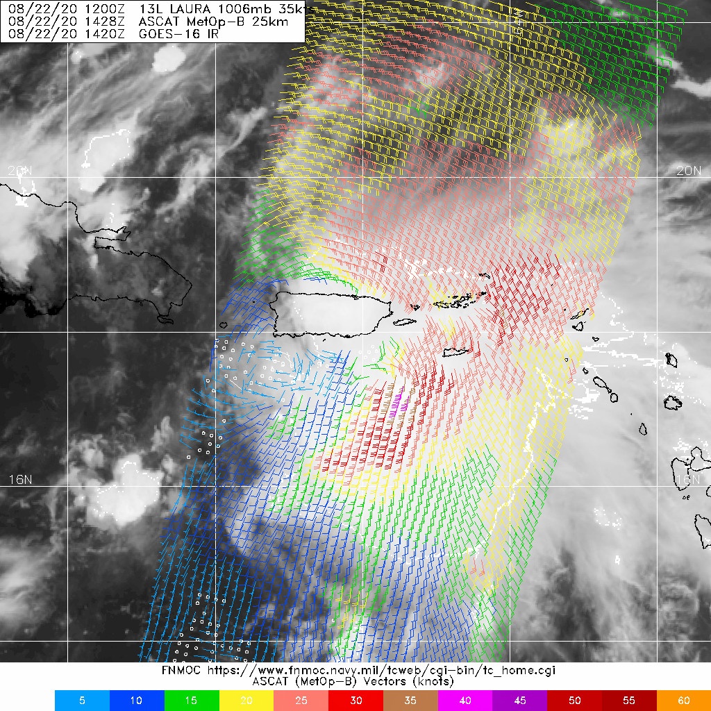
SFLcane wrote:ascat just showed the LLC is south PR.
Do you have an image you could post?
Last edited by eastcoastFL on Sat Aug 22, 2020 11:39 am, edited 1 time in total.
0 likes
Personal Forecast Disclaimer:
The posts in this forum are NOT official forecast and should not be used as such. They are just the opinion of the poster and may or may not be backed by sound meteorological data. They are NOT endorsed by any professional institution or storm2k.org. For official information, please refer to the NHC and NWS products.
The posts in this forum are NOT official forecast and should not be used as such. They are just the opinion of the poster and may or may not be backed by sound meteorological data. They are NOT endorsed by any professional institution or storm2k.org. For official information, please refer to the NHC and NWS products.
-
FLpanhandle91

- Category 5
- Posts: 1039
- Age: 34
- Joined: Mon Sep 13, 2010 3:50 pm
- Location: Fort Walton Beach, FL


Re: ATL: LAURA - Tropical Storm - Discussion
SFLcane wrote:ascat just showed the LLC is south PR.
Yes!, I am wrong as usual and the nhc is correct as usual lol. In that location this llc is not going to last because it slam right into DR. The MLC is going swing around and take over.
2 likes
The following post is NOT an official forecast and should not be used as such. It is just the opinion of the poster and may or may not be backed by sound meteorological data. It is NOT endorsed by any professional institution including storm2k.org For Official Information please refer to the NHC and NWS products.
-
HurricaneFrances04
- Category 2

- Posts: 597
- Joined: Mon Jun 25, 2012 8:09 am
- Location: Fort Lauderdale, Florida
-
eastcoastFL
- Category 5
- Posts: 3996
- Age: 44
- Joined: Thu Apr 12, 2007 12:29 pm
- Location: Palm City, FL
Re: ATL: LAURA - Tropical Storm - Discussion
FLpanhandle91 wrote:https://i.ibb.co/J3GPT59/WMBds20.png
So at the 6hr Mark HMON has the low right where this ascat pass shows it. But oddly it initialized north east of there.
0 likes
Personal Forecast Disclaimer:
The posts in this forum are NOT official forecast and should not be used as such. They are just the opinion of the poster and may or may not be backed by sound meteorological data. They are NOT endorsed by any professional institution or storm2k.org. For official information, please refer to the NHC and NWS products.
The posts in this forum are NOT official forecast and should not be used as such. They are just the opinion of the poster and may or may not be backed by sound meteorological data. They are NOT endorsed by any professional institution or storm2k.org. For official information, please refer to the NHC and NWS products.
-
Ivanhater

- Storm2k Moderator

- Posts: 11221
- Age: 39
- Joined: Fri Jul 01, 2005 8:25 am
- Location: Pensacola
Re: ATL: LAURA - Tropical Storm - Discussion
Please keep model runs in the models thread
2 likes
Michael
-
stormhunter7

- Category 2
- Posts: 763
- Joined: Mon May 26, 2008 3:13 pm
- Location: Panama City Beach, Florida
- Contact:
Re: ATL: LAURA - Tropical Storm - Discussion
I believe i disagree with the ASCAT pass. I can clearly see what it caught was a mid level center before high clouds obscured it. The surface winds were not moving in the right direction to be a surface feature. The surface low appears is on the NW side of PR. The mid-level is to the southeast of PR.
0 likes
The following post is NOT an official forecast and should not be used as such. It is just the opinion of the poster and may or may not be backed by sound meteorological data. It is NOT endorsed by any professional institution including storm2k.org For Official Information please refer to the NHC and NWS products. http://www.nhc.noaa.gov
-
eastcoastFL
- Category 5
- Posts: 3996
- Age: 44
- Joined: Thu Apr 12, 2007 12:29 pm
- Location: Palm City, FL
Re: ATL: LAURA - Tropical Storm - Discussion
Ivanhater wrote:Please keep model runs in the models thread
My bad. I just thought it was relevant to where the circulation is or is being forecast to be.
0 likes
Personal Forecast Disclaimer:
The posts in this forum are NOT official forecast and should not be used as such. They are just the opinion of the poster and may or may not be backed by sound meteorological data. They are NOT endorsed by any professional institution or storm2k.org. For official information, please refer to the NHC and NWS products.
The posts in this forum are NOT official forecast and should not be used as such. They are just the opinion of the poster and may or may not be backed by sound meteorological data. They are NOT endorsed by any professional institution or storm2k.org. For official information, please refer to the NHC and NWS products.
-
USTropics
- Professional-Met

- Posts: 2738
- Joined: Sun Aug 12, 2007 3:45 am
- Location: Florida State University
Re: ATL: LAURA - Tropical Storm - Discussion
PR radar for link for Laura:
http://moe.met.fsu.edu/~mnissenbaum/RadarArchive/TJUA/loop.html
http://moe.met.fsu.edu/~mnissenbaum/RadarArchive/TJUA/loop.html
2 likes
-
eastcoastFL
- Category 5
- Posts: 3996
- Age: 44
- Joined: Thu Apr 12, 2007 12:29 pm
- Location: Palm City, FL
Re: ATL: LAURA - Tropical Storm - Discussion
USTropics wrote:PR radar for link for Laura:
http://moe.met.fsu.edu/~mnissenbaum/RadarArchive/TJUA/loop.html
So are there multiple competing rotations? To the east of the ascat center there is a pretty strong rotation on radar
0 likes
Personal Forecast Disclaimer:
The posts in this forum are NOT official forecast and should not be used as such. They are just the opinion of the poster and may or may not be backed by sound meteorological data. They are NOT endorsed by any professional institution or storm2k.org. For official information, please refer to the NHC and NWS products.
The posts in this forum are NOT official forecast and should not be used as such. They are just the opinion of the poster and may or may not be backed by sound meteorological data. They are NOT endorsed by any professional institution or storm2k.org. For official information, please refer to the NHC and NWS products.
Re: ATL: LAURA - Tropical Storm - Discussion
eastcoastFL wrote:
That’s starting to look like a real storm on radar. I don’t think this one is going to die out
Looking at this loop the LLC is south of Puerto rico unless that's the MLC but it looks like a LLC just popped underneath
0 likes
-
eastcoastFL
- Category 5
- Posts: 3996
- Age: 44
- Joined: Thu Apr 12, 2007 12:29 pm
- Location: Palm City, FL
Re: ATL: LAURA - Tropical Storm - Discussion
St0rmTh0r wrote:eastcoastFL wrote:
That’s starting to look like a real storm on radar. I don’t think this one is going to die out
Looking at this loop the LLC is south of Puerto rico unless that's the MLC but it looks like a LLC just popped underneath
One which one are you looking at. I see what seems to be 2 rotations south of PR with the strongest along 66w and 17.5n
0 likes
Personal Forecast Disclaimer:
The posts in this forum are NOT official forecast and should not be used as such. They are just the opinion of the poster and may or may not be backed by sound meteorological data. They are NOT endorsed by any professional institution or storm2k.org. For official information, please refer to the NHC and NWS products.
The posts in this forum are NOT official forecast and should not be used as such. They are just the opinion of the poster and may or may not be backed by sound meteorological data. They are NOT endorsed by any professional institution or storm2k.org. For official information, please refer to the NHC and NWS products.
-
USTropics
- Professional-Met
- Posts: 2738
- Joined: Sun Aug 12, 2007 3:45 am
- Location: Florida State University
Re: ATL: LAURA - Tropical Storm - Discussion
eastcoastFL wrote:USTropics wrote:PR radar for link for Laura:
http://moe.met.fsu.edu/~mnissenbaum/RadarArchive/TJUA/loop.html
So are there multiple competing rotations? To the east of the ascat center there is a pretty strong rotation on radar
On radar we're seeing mostly the mid-level rotation. The low-level rotation is displaced from the mid-level currently (ASCAT shows the low-level vorticity).
3 likes
Who is online
Users browsing this forum: No registered users and 69 guests