Broad area of disturbed weather in the Western Caribbean Sea (Is INVEST 91L)
Moderator: S2k Moderators
Forum rules

The posts in this forum are NOT official forecasts and should not be used as such. They are just the opinion of the poster and may or may not be backed by sound meteorological data. They are NOT endorsed by any professional institution or STORM2K. For official information, please refer to products from the National Hurricane Center and National Weather Service.
-
stormlover2013
Re: Broad area of disturbed weather in the southwestern Caribbean Sea
models will keep going back and forth, first models aren't consistent till about 3-4 days out and this year it has been more on that 2-3 day range..I said yesterday I would give it 40-50 percent and as of right now that's what I am still looking at but don't target one spot till alot is at play here, fronts, troughs, high pressure and etc.
0 likes
-
Ivanhater

- Storm2k Moderator

- Posts: 11221
- Age: 39
- Joined: Fri Jul 01, 2005 8:25 am
- Location: Pensacola
Re: Broad area of disturbed weather in the southwestern Caribbean Sea
Interesting a lot of models turn this west into the gulf strengthening. Makes sense with high pressure dominating the SE
1 likes
Michael
-
stormlover2013
Re: Broad area of disturbed weather in the southwestern Caribbean Sea
the last 4 days the models have been bouncing around, they will keep doing the same until we have a center and get some data once we have a center.
0 likes
-
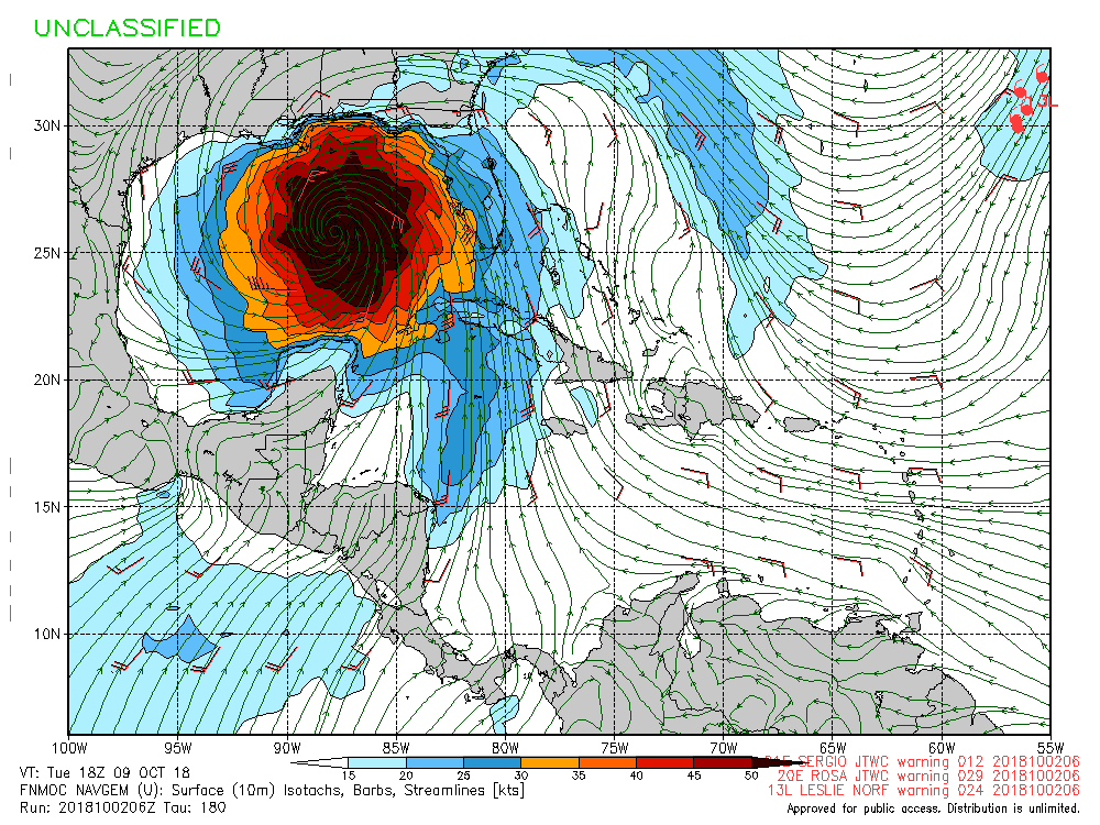
gatorcane

- S2K Supporter

- Posts: 23708
- Age: 48
- Joined: Sun Mar 13, 2005 3:54 pm
- Location: Boca Raton, FL
Re: Broad area of disturbed weather in the southwestern Caribbean Sea
Wow NAVGEM goes bonkers 
0 likes
-
toad strangler

- S2K Supporter
- Posts: 4546
- Joined: Sun Jul 28, 2013 3:09 pm
- Location: Earth
- Contact:
Re: Broad area of disturbed weather in the southwestern Caribbean Sea
gatorcane wrote:Wow NAVGEM goes bonkers
Verbatim, and yes we know its the Navy,(we know that post is coming lol ) that's a solid NW movement from Tidbits end of 144 hours off the Western tip of Cuba.
0 likes
My Weather Station
https://www.wunderground.com/dashboard/pws/KFLPORTS603
https://www.wunderground.com/dashboard/pws/KFLPORTS603

Re: Broad area of disturbed weather in the southwestern Caribbean Sea
Emmett_Brown wrote:I think the most intense convection that we are observing this morning is actually Kirk's remnants.
Let the memes begin
[youtube]https://youtu.be/I5pocMUIWwU[/youtube]
2 likes
-
Bocadude85

- Category 5

- Posts: 2991
- Age: 39
- Joined: Mon Apr 18, 2005 2:20 pm
- Location: Honolulu,Hi
Re: Broad area of disturbed weather in the southwestern Caribbean Sea
I am leaving for Cancun on Saturday, whatever comes of this needs to stay away from S.Fla and the Yucatán!
0 likes

Re: Broad area of disturbed weather in the southwestern Caribbean Sea
GFS FV3 eventually bombs out the cyclone at 959 mb just south of Gulfport MS moving north.
https://www.tropicaltidbits.com/analysis/models/?model=fv3p®ion=us&pkg=mslp_pcpn_frzn&runtime=2018100206&fh=270
https://www.tropicaltidbits.com/analysis/models/?model=fv3p®ion=us&pkg=mslp_pcpn_frzn&runtime=2018100206&fh=270
0 likes
-
toad strangler
- S2K Supporter
- Posts: 4546
- Joined: Sun Jul 28, 2013 3:09 pm
- Location: Earth
- Contact:
Re: Broad area of disturbed weather in the southwestern Caribbean Sea
And just for score keeping, the FV3 GFS ends in the far flung long range with another L over the YP
0 likes
My Weather Station
https://www.wunderground.com/dashboard/pws/KFLPORTS603
https://www.wunderground.com/dashboard/pws/KFLPORTS603
-
cycloneye

- Admin

- Posts: 149276
- Age: 69
- Joined: Thu Oct 10, 2002 10:54 am
- Location: San Juan, Puerto Rico
Re: Broad area of disturbed weather in the southwestern Caribbean Sea
1 likes
Visit the Caribbean-Central America Weather Thread where you can find at first post web cams,radars
and observations from Caribbean basin members Click Here
and observations from Caribbean basin members Click Here

Re: Broad area of disturbed weather in the southwestern Caribbean Sea
Anti-cyclone has developed SW of the convection.

0 likes
-
toad strangler
- S2K Supporter
- Posts: 4546
- Joined: Sun Jul 28, 2013 3:09 pm
- Location: Earth
- Contact:
Re: Broad area of disturbed weather in the southwestern Caribbean Sea
Looking at forecasted 500mb maps across the model suite I would open both eyes on the N Gulf Coast. The NAVGEM track from 6z seems very plausible. Of course that can change but it's pretty consistent all around. Intensity though is another animal ...
1 likes
My Weather Station
https://www.wunderground.com/dashboard/pws/KFLPORTS603
https://www.wunderground.com/dashboard/pws/KFLPORTS603
-
stormlover2013
Re: Broad area of disturbed weather in the southwestern Caribbean Sea
never trust the navy, cmc, or icon this far out maybe 3 days out but not this far out
0 likes

Re: Broad area of disturbed weather in the southwestern Caribbean Sea
The low level vortex is just east of Nicaragua while a pronounced mid level vortex is north of Colombia with deep convection, I don't see anything to come out of the mid level vortex with nothing but easterly winds underneath it, this mid level vortex is what last night's Euro run shows developing near Jamaica later this week.
0 likes
-
toad strangler
- S2K Supporter
- Posts: 4546
- Joined: Sun Jul 28, 2013 3:09 pm
- Location: Earth
- Contact:
Re: Broad area of disturbed weather in the southwestern Caribbean Sea
stormlover2013 wrote:never trust the navy, cmc, or icon this far out maybe 3 days out but not this far out
You seem to post this everyday about three time LOL
What I was saying, is the 500mb maps across the the model suite are very similar. Thus it could make that NAVGEM track very plausible.
I am in NO WAY singling out the NAVGEM all by itself.
0 likes
My Weather Station
https://www.wunderground.com/dashboard/pws/KFLPORTS603
https://www.wunderground.com/dashboard/pws/KFLPORTS603
Re: Broad area of disturbed weather in the southwestern Caribbean Sea
stormlover2013 wrote:never trust the navy, cmc, or icon this far out maybe 3 days out but not this far out
I’d side with the consensus of the GFS, Euro, and UKMET over the navy and CMC just about at all timeframes if they’re weaker. At least those 3 don’t have a tendency to overstrengthen when nearby shear is very high.
0 likes
Personal Forecast Disclaimer:
The posts in this forum are NOT official forecasts and should not be used as such. They are just the opinion of the poster and may or may not be backed by sound meteorological data. They are NOT endorsed by any professional institution or storm2k.org. For official information, please refer to the NHC and NWS products.
The posts in this forum are NOT official forecasts and should not be used as such. They are just the opinion of the poster and may or may not be backed by sound meteorological data. They are NOT endorsed by any professional institution or storm2k.org. For official information, please refer to the NHC and NWS products.
-
Aric Dunn
- Category 5
- Posts: 21238
- Age: 43
- Joined: Sun Sep 19, 2004 9:58 pm
- Location: Ready for the Chase.
- Contact:
Re: Broad area of disturbed weather in the southwestern Caribbean Sea
nice convective blob. unfortunately, that is well east of the low pressure and broad circulation near the coast of Nicaragua. That would have to persist for a long time to change the flow. which it could slowly but most likely it will collapse over the next few hours. only ese flow through that entire mass.
0 likes
Note: If I make a post that is brief. Please refer back to previous posts for the analysis or reasoning. I do not re-write/qoute what my initial post said each time.
If there is nothing before... then just ask
Space & Atmospheric Physicist, Embry-Riddle Aeronautical University,
I believe the sky is falling...
If there is nothing before... then just ask
Space & Atmospheric Physicist, Embry-Riddle Aeronautical University,
I believe the sky is falling...
Re: Broad area of disturbed weather in the southwestern Caribbean Sea
Aric Dunn wrote:nice convective blob. unfortunately, that is well east of the low pressure and broad circulation near the coast of Nicaragua. That would have to persist for a long time to change the flow. which it could slowly.
I was going to say that this convection is pretty far to the east.
1 likes
Personal Forecast Disclaimer:
The posts in this forum are NOT official forecasts and should not be used as such. They are just the opinion of the poster and may or may not be backed by sound meteorological data. They are NOT endorsed by any professional institution or storm2k.org. For official information, please refer to the NHC and NWS products.
The posts in this forum are NOT official forecasts and should not be used as such. They are just the opinion of the poster and may or may not be backed by sound meteorological data. They are NOT endorsed by any professional institution or storm2k.org. For official information, please refer to the NHC and NWS products.
Who is online
Users browsing this forum: TeamPlayersBlue, Ulf and 169 guests