EPAC: FELICIA - Post-Tropical

Moderator: S2k Moderators

Message
Author
User avatar
aspen
Category 5
Category 5
Posts: 8818
Joined: Sat Oct 12, 2019 7:10 pm
Location: Connecticut, USA

Re: EPAC: INVEST 96E

#221 Postby aspen » Fri Jul 16, 2021 5:40 am

Kingarabian wrote:18z HWRF. Simply to come back and look at it when it busts.
https://i.imgur.com/v6erMFZ.gif

It makes it annular for a while so it's not that crazy though.

Well that stance didn’t age well lol.

Surprising to see an initial HWRF run verify this well. As I mentioned before, usually the early runs overdo intensity.
7 likes   
Irene '11 Sandy '12 Hermine '16 5/15/2018 Derecho Fay '20 Isaias '20 Elsa '21 Henri '21 Ida '21

I am only a meteorology enthusiast who knows a decent amount about tropical cyclones. Look to the professional mets, the NHC, or your local weather office for the best information.

User avatar
Kingarabian
S2K Supporter
S2K Supporter
Posts: 15980
Joined: Sat Aug 08, 2009 3:06 am
Location: Honolulu, Hawaii

Re: EPAC: INVEST 96E

#222 Postby Kingarabian » Fri Jul 16, 2021 5:45 am

aspen wrote:
Kingarabian wrote:18z HWRF. Simply to come back and look at it when it busts.
https://i.imgur.com/v6erMFZ.gif

It makes it annular for a while so it's not that crazy though.

Well that stance didn’t age well lol.

Surprising to see an initial HWRF run verify this well. As I mentioned before, usually the early runs overdo intensity.

Lol sorry HWRF. I mean even a broken clock is right twice a day right.

Image
2 likes   
RIP Kobe Bryant

User avatar
InfernoFlameCat
Category 5
Category 5
Posts: 2102
Age: 22
Joined: Mon Dec 14, 2020 10:52 am
Location: Buford, GA

Re: EPAC: FELICIA - Hurricane

#223 Postby InfernoFlameCat » Fri Jul 16, 2021 6:30 am

Gorgeous. Glad to see my prediction at cat 3 came true. Now I believe it will hit cat 4 at peak.
1 likes   
I am by no means a professional. DO NOT look at my forecasts for official information or make decisions based on what I post.

Goal: to become a registered expert over tropical and subtropical cyclones.

User avatar
aspen
Category 5
Category 5
Posts: 8818
Joined: Sat Oct 12, 2019 7:10 pm
Location: Connecticut, USA

Re: EPAC: FELICIA - Hurricane

#224 Postby aspen » Fri Jul 16, 2021 6:57 am

Felicia’s eye has rapidly cleared and warmed over the last few hours, and is now around 12-13C and surrounded by a B ring with some W mixed in too. I think this is good enough for 110-115 kt.
0 likes   
Irene '11 Sandy '12 Hermine '16 5/15/2018 Derecho Fay '20 Isaias '20 Elsa '21 Henri '21 Ida '21

I am only a meteorology enthusiast who knows a decent amount about tropical cyclones. Look to the professional mets, the NHC, or your local weather office for the best information.

Sciencerocks
Category 5
Category 5
Posts: 9155
Age: 39
Joined: Thu Jul 06, 2017 1:51 am

Re: EPAC: FELICIA - Hurricane

#225 Postby Sciencerocks » Fri Jul 16, 2021 7:04 am

Image
9 likes   

User avatar
cycloneye
Admin
Admin
Posts: 145294
Age: 68
Joined: Thu Oct 10, 2002 10:54 am
Location: San Juan, Puerto Rico

Re: EPAC: FELICIA - Hurricane

#226 Postby cycloneye » Fri Jul 16, 2021 7:31 am

110 kts

Best Track Position and Intensity as of:

Friday, Jul. 16, 2021 12:00 Z

Wind (1 min. avg.):

110 knots (127 mph | 57 m/s | 204 km/h)

Pressure:

962 mb (28.41 inHg | 962 hPa)

Location at the time:

913 statute miles (1,469 km) to the SW (234°) from Cabo San Lucas, Baja California Sur, Mexico.

Coordinates:

15.1N 121.2W
5 likes   
Visit the Caribbean-Central America Weather Thread where you can find at first post web cams,radars
and observations from Caribbean basin members Click Here

User avatar
cycloneye
Admin
Admin
Posts: 145294
Age: 68
Joined: Thu Oct 10, 2002 10:54 am
Location: San Juan, Puerto Rico

Re: EPAC: FELICIA - Hurricane

#227 Postby cycloneye » Fri Jul 16, 2021 7:38 am

A. 06E (FELICIA)

B. 16/1130Z

C. 15.1N

D. 121.1W

E. ONE/GOES-W

F. T6.0/6.0

G. IR/EIR

H. REMARKS...A WMG EYE SURROUNDED BY B AND EMBEDDED IN LG YIELDS A
DT OF 6.0 AFTER AN EYE ADJUSTMENT OF 1.0. THE MET IS 5.5 BASED ON AN
ONGOING DEVELOPMENT TREND. THE PT AGREES WITH 5.5. FT IS BASED ON DT.

I. ADDL POSITIONS

NIL


...COVERDALE
0 likes   
Visit the Caribbean-Central America Weather Thread where you can find at first post web cams,radars
and observations from Caribbean basin members Click Here

User avatar
Yellow Evan
Professional-Met
Professional-Met
Posts: 16143
Age: 27
Joined: Fri Jul 15, 2011 12:48 pm
Location: Henderson, Nevada/Honolulu, HI
Contact:

Re: EPAC: FELICIA - Hurricane

#228 Postby Yellow Evan » Fri Jul 16, 2021 7:59 am

----- Current Analysis -----
Date : 16 JUL 2021 Time : 122032 UTC
Lat : 15:07:11 N Lon : 121:14:23 W


CI# /Pressure/ Vmax
5.7 / 957.3mb/107.2kt


Final T# Adj T# Raw T#
5.7 5.7 5.7

Estimated radius of max. wind based on IR : 14 km

Center Temp : +15.1C Cloud Region Temp : -58.7C

Scene Type : EYE
0 likes   

User avatar
HurricaneEnzo
Category 2
Category 2
Posts: 739
Joined: Wed Mar 14, 2018 12:18 pm
Location: Newport, NC (Hurricane Alley)

Re: EPAC: FELICIA - Hurricane

#229 Postby HurricaneEnzo » Fri Jul 16, 2021 8:04 am

She's a beaut. EPAC Cat 4 printer go brrrrrrrrrr
2 likes   
Bertha 96' - Fran 96' - Bonnie 98' - Dennis 99' - Floyd 99' - Isabel 03' - Alex 04' - Ophelia 05' - Irene 11' - Arthur 14' - Matthew 16' - Florence 18' - Dorian 19' - Isaias 20' (countless other tropical storms and Hurricane swipes)

I am not a Professional Met just an enthusiast. Get your weather forecasts from the Pros!

User avatar
Yellow Evan
Professional-Met
Professional-Met
Posts: 16143
Age: 27
Joined: Fri Jul 15, 2011 12:48 pm
Location: Henderson, Nevada/Honolulu, HI
Contact:

Re: EPAC: FELICIA - Hurricane

#230 Postby Yellow Evan » Fri Jul 16, 2021 8:09 am

Image

Clear as a day T6.0.
2 likes   

User avatar
Yellow Evan
Professional-Met
Professional-Met
Posts: 16143
Age: 27
Joined: Fri Jul 15, 2011 12:48 pm
Location: Henderson, Nevada/Honolulu, HI
Contact:

Re: EPAC: FELICIA - Hurricane

#231 Postby Yellow Evan » Fri Jul 16, 2021 8:22 am

0 likes   

User avatar
aspen
Category 5
Category 5
Posts: 8818
Joined: Sat Oct 12, 2019 7:10 pm
Location: Connecticut, USA

Re: EPAC: INVEST 96E

#232 Postby aspen » Fri Jul 16, 2021 8:48 am

aspen wrote:Another cool ENSO EPac season slop storm, coming up.

Sorry that I doubted you Felicia lol
3 likes   
Irene '11 Sandy '12 Hermine '16 5/15/2018 Derecho Fay '20 Isaias '20 Elsa '21 Henri '21 Ida '21

I am only a meteorology enthusiast who knows a decent amount about tropical cyclones. Look to the professional mets, the NHC, or your local weather office for the best information.

User avatar
Yellow Evan
Professional-Met
Professional-Met
Posts: 16143
Age: 27
Joined: Fri Jul 15, 2011 12:48 pm
Location: Henderson, Nevada/Honolulu, HI
Contact:

Re: EPAC: FELICIA - Hurricane

#233 Postby Yellow Evan » Fri Jul 16, 2021 9:38 am

----- Current Analysis -----
Date : 16 JUL 2021 Time : 135032 UTC
Lat : 15:06:35 N Lon : 121:26:59 W


CI# /Pressure/ Vmax
5.7 / 954.0mb/107.2kt


Final T# Adj T# Raw T#
5.7 5.8 5.8

Estimated radius of max. wind based on IR : 15 km

Center Temp : +16.6C Cloud Region Temp : -59.2C

Scene Type : EYE
0 likes   

User avatar
Stormybajan
Category 1
Category 1
Posts: 448
Joined: Thu May 20, 2021 3:21 pm
Location: Windward Islands

Re: EPAC: FELICIA - Hurricane

#234 Postby Stormybajan » Fri Jul 16, 2021 9:40 am

I know they went with 125 mph with Felicia for the new update but surely shes atleast a 130 mph Cat 4 right now
0 likes   
Sad West Indies and Manchester United fan ⚽️

Subtrop
Category 2
Category 2
Posts: 670
Joined: Sun Feb 21, 2021 9:45 pm

Re: EPAC: FELICIA - Hurricane

#235 Postby Subtrop » Fri Jul 16, 2021 9:42 am

:double:

WTPZ41 KNHC 161433
TCDEP1

Hurricane Felicia Discussion Number 10
NWS National Hurricane Center Miami FL EP062021
800 AM PDT Fri Jul 16 2021

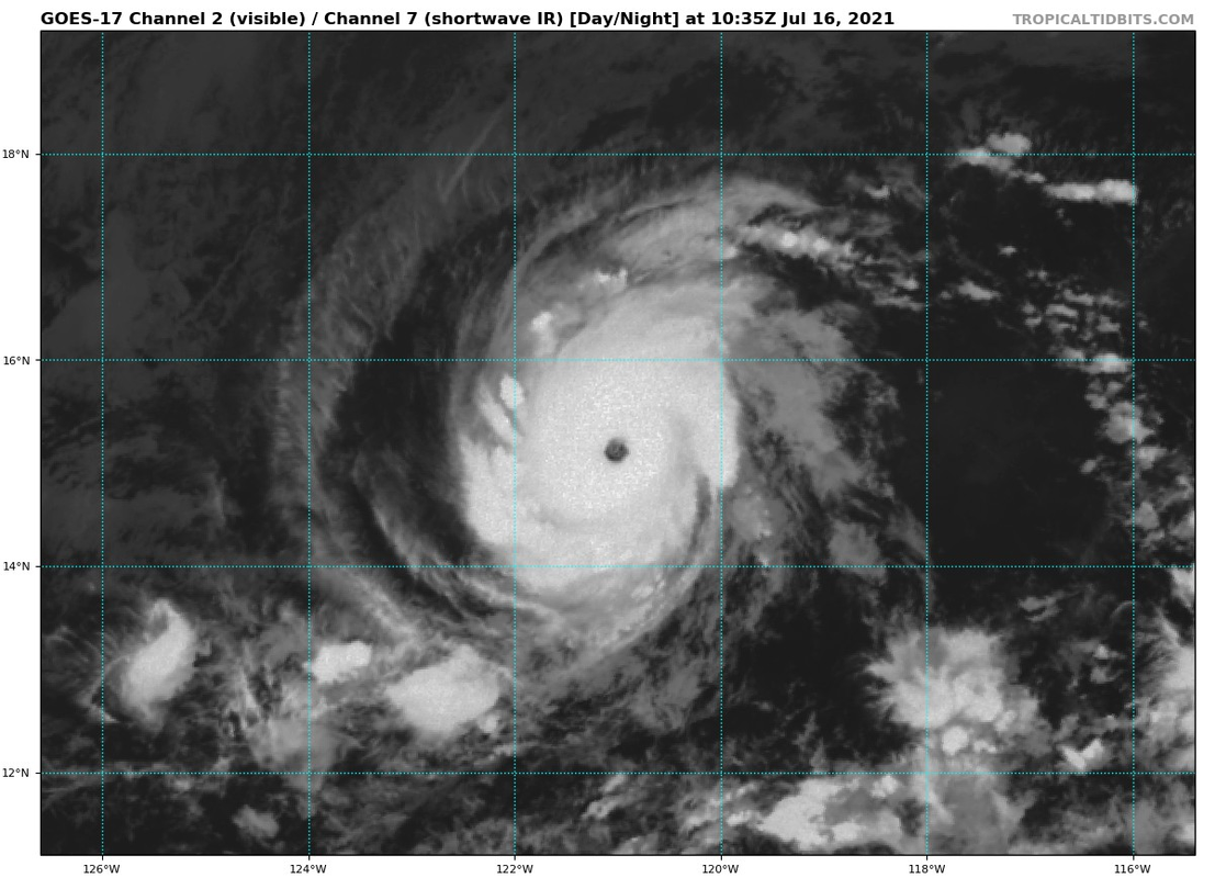
Compact Hurricane Felicia has continued to rapidly strengthen this
morning with a well-defined, warm (>15C) clear eye now evident in
infrared satellite imagery. However, the convective cloud tops
surrounding the eye have warmed by almost 10 deg C during the past
several hours, and a 1022Z ATMS microwave satellite pass showed the
inner core convection a little less organized. Subjective satellite
intensity estimates from TAFB and SAB were a consensus T6.0/115 kt
and objective estimates from UW-CIMSS ADT over the past couple of
hours have averaged T5.7/105 kt. The initial intensity is raised to
110 kt, and just below category 4 strength, for this advisory based
on a blend of the various satellite intensity estimates and the
slightly degraded aforementioned convective features.

Felicia is moving west-southwestward or 255/07 kt. Strong deep-layer
ridging to the north of the hurricane is expected to keep Felicia
moving west-southwestward for the next 12-24 h. Thereafter, the
global and regional models all show the ridge relaxing somewhat,
which should allow Felicia to move more westward in the 24-120-hour
forecast period. The new NHC track forecast is essentially on top of
and just an update of the previous advisory track, and lies near the
middle of the tightly packed simple and corrected consensus models
TVCE, GFEX, and NOAA-HCCA.

Some additional slight strengthening could occur this morning due to
low vertical shear and warm SSTs conditions, with Felicia briefly
becoming a category 4 hurricane. However, the warm water beneath the
powerful hurricane isn't very deep as indicated by upper-ocean heat
content values currently only around 5 units, which suggests that
cold upwelling could begin at any time during the next 12 hours.
Ocean heat content values are forecast to remain below 10 units from
24-96 hours, and decreasing to less than zero thereafter. Thus, slow
weakening is forecast to begin by 24 h and continue through the
remainder of the forecast period despite the favorable low (<10 kt)
vertical wind shear regime that Felicia will be moving through. The
new intensity forecast is similar to the previous advisory, and
closely follows the consensus intensity models NOAA-HCCA and IVCN.


FORECAST POSITIONS AND MAX WINDS

INIT 16/1500Z 15.0N 121.6W 110 KT 125 MPH
12H 17/0000Z 14.8N 122.7W 110 KT 125 MPH
24H 17/1200Z 13.1N 140.5W 105 KT 120 MPH
36H 18/0000Z 14.6N 126.0W 100 KT 115 MPH

48H 18/1200Z 14.7N 127.8W 90 KT 105 MPH
60H 19/0000Z 14.8N 129.6W 85 KT 100 MPH
72H 19/1200Z 14.8N 131.4W 80 KT 90 MPH
96H 20/1200Z 14.4N 135.0W 65 KT 75 MPH
120H 21/1200Z 13.7N 138.5W 55 KT 65 MPH

$$
Forecaster Stewart
0 likes   

User avatar
Yellow Evan
Professional-Met
Professional-Met
Posts: 16143
Age: 27
Joined: Fri Jul 15, 2011 12:48 pm
Location: Henderson, Nevada/Honolulu, HI
Contact:

Re: EPAC: FELICIA - Hurricane

#236 Postby Yellow Evan » Fri Jul 16, 2021 9:45 am

Image
8 likes   

User avatar
aspen
Category 5
Category 5
Posts: 8818
Joined: Sat Oct 12, 2019 7:10 pm
Location: Connecticut, USA

Re: EPAC: FELICIA - Hurricane

#237 Postby aspen » Fri Jul 16, 2021 9:50 am

Stormybajan wrote:I know they went with 125 mph with Felicia for the new update but surely shes atleast a 130 mph Cat 4 right now

The NHC did say Felicia could become a Cat 4, but notes that OHC values are quite low and upwelling could become an issue very quickly. Felicia is very strong but not very fast, meaning that is indeed an issue.
1 likes   
Irene '11 Sandy '12 Hermine '16 5/15/2018 Derecho Fay '20 Isaias '20 Elsa '21 Henri '21 Ida '21

I am only a meteorology enthusiast who knows a decent amount about tropical cyclones. Look to the professional mets, the NHC, or your local weather office for the best information.

User avatar
Kingarabian
S2K Supporter
S2K Supporter
Posts: 15980
Joined: Sat Aug 08, 2009 3:06 am
Location: Honolulu, Hawaii

Re: EPAC: FELICIA - Hurricane

#238 Postby Kingarabian » Fri Jul 16, 2021 9:53 am

I never thought I would see the NHC use an ATMS pass to justify against upgrading a storm. ATMS is the worst we have in microwave...

Never forget how ATMS resolved Iota's inner structure despite the insane appearance on satellite imagery. It didn't find an eyewall despite the eye being that warm.
 https://twitter.com/WxTca/status/1405210648678744070


2 likes   
RIP Kobe Bryant

User avatar
Yellow Evan
Professional-Met
Professional-Met
Posts: 16143
Age: 27
Joined: Fri Jul 15, 2011 12:48 pm
Location: Henderson, Nevada/Honolulu, HI
Contact:

Re: EPAC: FELICIA - Hurricane

#239 Postby Yellow Evan » Fri Jul 16, 2021 10:05 am

Image

I mean the 3 way average supports 110 knots but this isn’t losing organization by any means contrary to what an old low resolution pass may suggest.
Last edited by Yellow Evan on Fri Jul 16, 2021 10:08 am, edited 2 times in total.
0 likes   

User avatar
Kingarabian
S2K Supporter
S2K Supporter
Posts: 15980
Joined: Sat Aug 08, 2009 3:06 am
Location: Honolulu, Hawaii

Re: EPAC: FELICIA - Hurricane

#240 Postby Kingarabian » Fri Jul 16, 2021 10:07 am

First visible:
Image
4 likes   
RIP Kobe Bryant


Return to “2021”

Who is online

Users browsing this forum: No registered users and 5 guests