NATL: HUMBERTO - Remnants - Discussion
Moderator: S2k Moderators

Re: NATL: HUMBERTO - Hurricane - Discussion
I’m curious what the NHC does with Humberto at the next advisory. I think satellite makes a solid case for 135 kts even by their criteria, but I’m guessing they may go 130 with a note about how that intensity “may be conservative”.
Last edited by Beef Stew on Sat Sep 27, 2025 9:32 am, edited 2 times in total.
0 likes

Re: NATL: HUMBERTO - Hurricane - Discussion
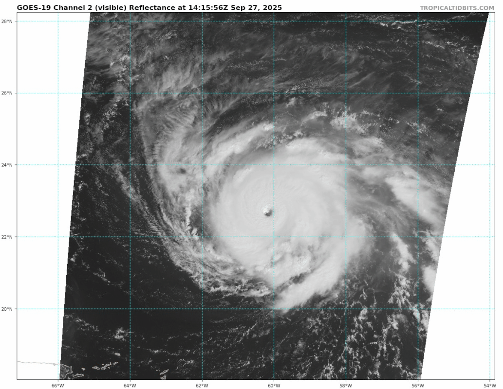
Looks like Irma.

6 likes
Igor 2010, Sandy 2012, Fay 2014, Gonzalo 2014, Joaquin 2015, Nicole 2016, Humberto 2019, Imelda 2025
I am only a tropical weather enthusiast. My predictions are not official and may or may not be backed by sound meteorological data. For official information, please refer to the NHC and NWS products.
I am only a tropical weather enthusiast. My predictions are not official and may or may not be backed by sound meteorological data. For official information, please refer to the NHC and NWS products.
-
MEANINGLESS_NUMBERS
- Category 2

- Posts: 503
- Joined: Mon Nov 02, 2020 1:43 pm
Re: NATL: HUMBERTO - Hurricane - Discussion
That’s a cat five. Expect the formal designation shortly. There was a time that they wouldn’t call a 5 without recon but they’ve been more willing in recent years.
0 likes
Emily '87, Felix '95, Gert '99, Fabian '03, Humberto '19, Paulette '20, Teddy '20, Fiona '22, Lee '23, Ernesto '24, Humberto/Imelda '25

Re: NATL: HUMBERTO - Hurricane - Discussion
zzzh wrote:The meso sector finally comes in.
5 likes
TC naming lists: retirements and intensity
Most aggressive Advisory #1's in North Atlantic (cr. kevin for starting the list)
Most aggressive Advisory #1's in North Atlantic (cr. kevin for starting the list)
-
StormWeather

- Category 1

- Posts: 475
- Joined: Wed Jun 05, 2024 2:34 pm
Re: NATL: HUMBERTO - Hurricane - Discussion
MEANINGLESS_NUMBERS wrote:That’s a cat five. Expect the formal designation shortly.
If you had told me two weeks ago that we would have two Cat 5s in a year as quiet as it’s been up to now, I wouldn’t have believed it.
2 likes
Just an average cyclone tracker
The posts in this forum are NOT official forecasts and should not be used as such. They are just the opinion of the poster and may or may not be backed by sound meteorological data. They are NOT endorsed by any professional institution or storm2k.org. For official information, please refer to the NHC and NWS products
The posts in this forum are NOT official forecasts and should not be used as such. They are just the opinion of the poster and may or may not be backed by sound meteorological data. They are NOT endorsed by any professional institution or storm2k.org. For official information, please refer to the NHC and NWS products

Re: NATL: HUMBERTO - Hurricane - Discussion
StormWeather wrote:MEANINGLESS_NUMBERS wrote:That’s a cat five. Expect the formal designation shortly.
If you had told me two weeks ago that we would have two Cat 5s in a year as quiet as it’s been up to now, I wouldn’t have believed it.
Severe weather tends to do that.
1 likes
Re: NATL: HUMBERTO - Hurricane - Discussion
StormWeather wrote:MEANINGLESS_NUMBERS wrote:That’s a cat five. Expect the formal designation shortly.
If you had told me two weeks ago that we would have two Cat 5s in a year as quiet as it’s been up to now, I wouldn’t have believed it.
I personally suspect that Gabrielle probably peaked at around 130 kts as well- while not a cat 5, still an incredibly strong hurricane. So the weakest (assuming Humberto gets bumped up to >= 130 kts) of the three hurricanes we’ve had this year would’ve been a season-defining (intensity-wise) storm in numerous past seasons…
1 likes

Re: NATL: HUMBERTO - Hurricane - Discussion
125kts lol
Hurricane Humberto Advisory Number 12
NWS National Hurricane Center Miami FL AL082025
1100 AM AST Sat Sep 27 2025
...DANGEROUS SURF FROM MAJOR HURRICANE HUMBERTO EXPECTED TO
AFFECT CARIBBEAN AND BERMUDA SHORES LATER THIS WEEKEND...
SUMMARY OF 1100 AM AST...1500 UTC...INFORMATION
-----------------------------------------------
LOCATION...22.7N 60.2W
ABOUT 365 MI...585 KM NNE OF THE NORTHERN LEEWARD ISLANDS
ABOUT 720 MI...1160 KM SSE OF BERMUDA
MAXIMUM SUSTAINED WINDS...145 MPH...230 KM/H
PRESENT MOVEMENT...WNW OR 295 DEGREES AT 8 MPH...13 KM/H
MINIMUM CENTRAL PRESSURE...938 MB...27.70 INCHES
0 likes
Re: NATL: HUMBERTO - Hurricane - Discussion
Travorum wrote:125kts lolHurricane Humberto Advisory Number 12
NWS National Hurricane Center Miami FL AL082025
1100 AM AST Sat Sep 27 2025
...DANGEROUS SURF FROM MAJOR HURRICANE HUMBERTO EXPECTED TO
AFFECT CARIBBEAN AND BERMUDA SHORES LATER THIS WEEKEND...
SUMMARY OF 1100 AM AST...1500 UTC...INFORMATION
-----------------------------------------------
LOCATION...22.7N 60.2W
ABOUT 365 MI...585 KM NNE OF THE NORTHERN LEEWARD ISLANDS
ABOUT 720 MI...1160 KM SSE OF BERMUDA
MAXIMUM SUSTAINED WINDS...145 MPH...230 KM/H
PRESENT MOVEMENT...WNW OR 295 DEGREES AT 8 MPH...13 KM/H
MINIMUM CENTRAL PRESSURE...938 MB...27.70 INCHES
I understand they have their hands full with Imelda, but that is way too low
2 likes
-
Hurricane2022

- Category 5

- Posts: 2016
- Joined: Tue Aug 23, 2022 11:38 pm
- Location: Araçatuba, Brazil
Re: NATL: HUMBERTO - Hurricane - Discussion
Travorum wrote:125kts lolHurricane Humberto Advisory Number 12
NWS National Hurricane Center Miami FL AL082025
1100 AM AST Sat Sep 27 2025
...DANGEROUS SURF FROM MAJOR HURRICANE HUMBERTO EXPECTED TO
AFFECT CARIBBEAN AND BERMUDA SHORES LATER THIS WEEKEND...
SUMMARY OF 1100 AM AST...1500 UTC...INFORMATION
-----------------------------------------------
LOCATION...22.7N 60.2W
ABOUT 365 MI...585 KM NNE OF THE NORTHERN LEEWARD ISLANDS
ABOUT 720 MI...1160 KM SSE OF BERMUDA
MAXIMUM SUSTAINED WINDS...145 MPH...230 KM/H
PRESENT MOVEMENT...WNW OR 295 DEGREES AT 8 MPH...13 KM/H
MINIMUM CENTRAL PRESSURE...938 MB...27.70 INCHES
We're back to late-september 2021...
3 likes
Sorry for the bad English sometimes...!
For reliable and detailed information for any meteorological phenomenon, please consult the National Hurricane Center, Joint Typhoon Warning Center , or your local Meteo Center.
--------
ECCE OMNIA NOVA FACIAM (Ap 21,5).
For reliable and detailed information for any meteorological phenomenon, please consult the National Hurricane Center, Joint Typhoon Warning Center , or your local Meteo Center.
--------
ECCE OMNIA NOVA FACIAM (Ap 21,5).
Re: NATL: HUMBERTO - Hurricane - Discussion
Travorum wrote:125kts lolHurricane Humberto Advisory Number 12
NWS National Hurricane Center Miami FL AL082025
1100 AM AST Sat Sep 27 2025
...DANGEROUS SURF FROM MAJOR HURRICANE HUMBERTO EXPECTED TO
AFFECT CARIBBEAN AND BERMUDA SHORES LATER THIS WEEKEND...
SUMMARY OF 1100 AM AST...1500 UTC...INFORMATION
-----------------------------------------------
LOCATION...22.7N 60.2W
ABOUT 365 MI...585 KM NNE OF THE NORTHERN LEEWARD ISLANDS
ABOUT 720 MI...1160 KM SSE OF BERMUDA
MAXIMUM SUSTAINED WINDS...145 MPH...230 KM/H
PRESENT MOVEMENT...WNW OR 295 DEGREES AT 8 MPH...13 KM/H
MINIMUM CENTRAL PRESSURE...938 MB...27.70 INCHES
Classic case of no recon.

7 likes
Igor 2010, Sandy 2012, Fay 2014, Gonzalo 2014, Joaquin 2015, Nicole 2016, Humberto 2019, Imelda 2025
I am only a tropical weather enthusiast. My predictions are not official and may or may not be backed by sound meteorological data. For official information, please refer to the NHC and NWS products.
I am only a tropical weather enthusiast. My predictions are not official and may or may not be backed by sound meteorological data. For official information, please refer to the NHC and NWS products.
-
Hurricane2022
- Category 5
- Posts: 2016
- Joined: Tue Aug 23, 2022 11:38 pm
- Location: Araçatuba, Brazil
Re: NATL: HUMBERTO - Hurricane - Discussion
Kazmit wrote:Travorum wrote:125kts lolHurricane Humberto Advisory Number 12
NWS National Hurricane Center Miami FL AL082025
1100 AM AST Sat Sep 27 2025
...DANGEROUS SURF FROM MAJOR HURRICANE HUMBERTO EXPECTED TO
AFFECT CARIBBEAN AND BERMUDA SHORES LATER THIS WEEKEND...
SUMMARY OF 1100 AM AST...1500 UTC...INFORMATION
-----------------------------------------------
LOCATION...22.7N 60.2W
ABOUT 365 MI...585 KM NNE OF THE NORTHERN LEEWARD ISLANDS
ABOUT 720 MI...1160 KM SSE OF BERMUDA
MAXIMUM SUSTAINED WINDS...145 MPH...230 KM/H
PRESENT MOVEMENT...WNW OR 295 DEGREES AT 8 MPH...13 KM/H
MINIMUM CENTRAL PRESSURE...938 MB...27.70 INCHES
Classic case of no recon.
Recent
objective and subjective intensity estimates range from near 120 kt
to just below 130 kt, so the initial intensity remains 125 kt.
objective and subjective intensity estimates range from near 120 kt
to just below 130 kt, so the initial intensity remains 125 kt.
The posts in this forum are NOT official forecasts and should not be used as such. They are just the opinion of the poster and may or may not be backed by sound meteorological data. They are NOT endorsed by any professional institution or STORM2K. For official information, please refer to products from the NHC and NWS.
2 likes
Sorry for the bad English sometimes...!
For reliable and detailed information for any meteorological phenomenon, please consult the National Hurricane Center, Joint Typhoon Warning Center , or your local Meteo Center.
--------
ECCE OMNIA NOVA FACIAM (Ap 21,5).
For reliable and detailed information for any meteorological phenomenon, please consult the National Hurricane Center, Joint Typhoon Warning Center , or your local Meteo Center.
--------
ECCE OMNIA NOVA FACIAM (Ap 21,5).
Re: NATL: HUMBERTO - Hurricane - Discussion
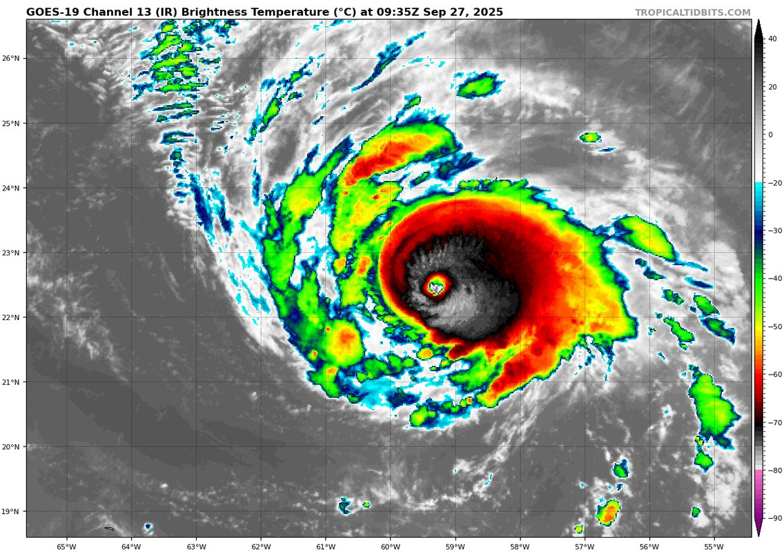
Since the last advisory, Humberto's eye has once again become better
defined and recent WSF-M microwave imagery at 1001 UTC did not
indicate the presence of concentric eyewalls. Together, these data
suggest Humberto completed its eyewall replacement cycle. Recent
objective and subjective intensity estimates range from near 120 kt
to just below 130 kt, so the initial intensity remains 125 kt.
2 likes
Re: NATL: HUMBERTO - Hurricane - Discussion
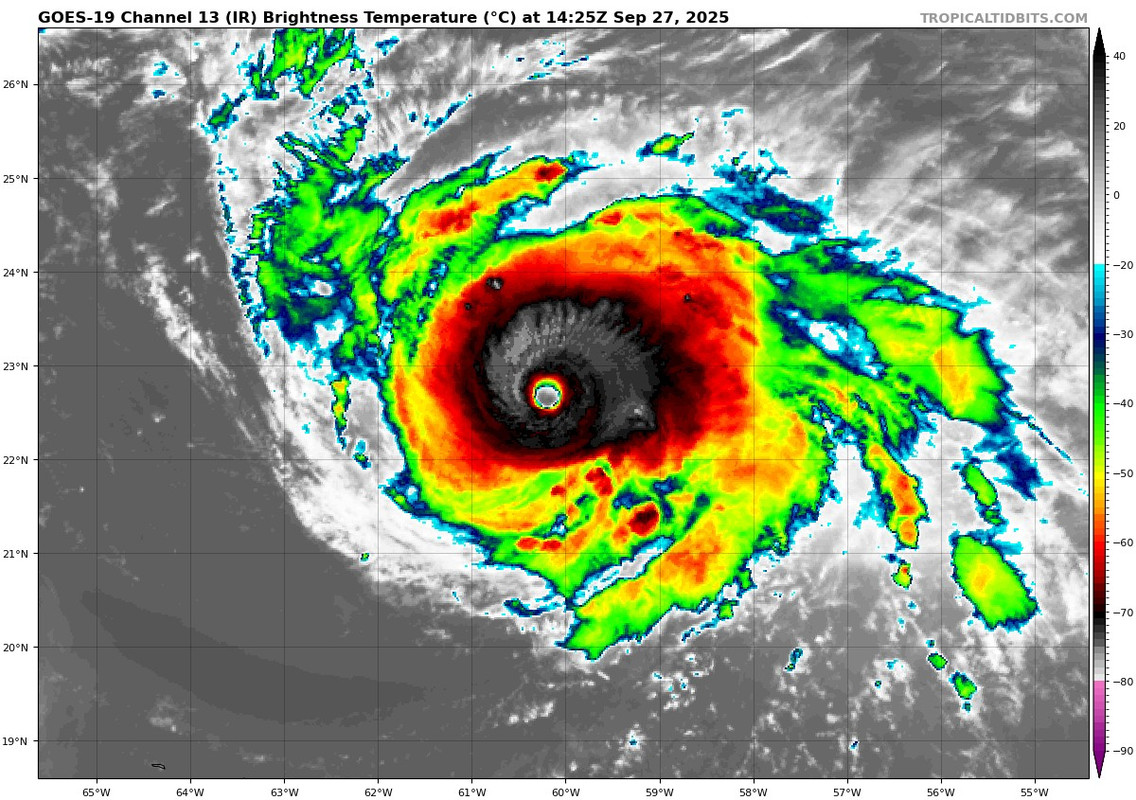
So allegedly, these two frames are at the same intensity:
(I don't have imagery from earlier than this handy, so feel free to add)
(I don't have imagery from earlier than this handy, so feel free to add)
4 likes
TC naming lists: retirements and intensity
Most aggressive Advisory #1's in North Atlantic (cr. kevin for starting the list)
Most aggressive Advisory #1's in North Atlantic (cr. kevin for starting the list)
-
cheezyWXguy

- Category 5
- Posts: 6281
- Joined: Mon Feb 13, 2006 12:29 am
- Location: Dallas, TX
Re: NATL: HUMBERTO - Hurricane - Discussion
Is Humberto being underestimated because of its small size, or is it that the ring of deepest convection isn’t thick enough yet for a higher estimate?
0 likes

Re: NATL: HUMBERTO - Hurricane - Discussion
cheezyWXguy wrote:Is Humberto being underestimated because of its small size, or is it that the ring of deepest convection isn’t thick enough yet for a higher estimate?
The W ring definitely hasn't been consistently thick enough for a T7.0, although there might have been a few frames where it was. The B ring however has been consistently thick enough for a T6.5 for several hours. the 12z subjective dvorak fixes were T6.0 from SAB and T6.5 from TAFB (right when the B ring was at its thinnest), ADT is still recovering from a poorer appearance overnight, and other satellite estimates are between 120kts and 130kts. So it seems the NHC doesn't want to show strengthening faster than what convention would suggest, despite the subjectively improved satellite appearance.
2 likes
-
Sciencerocks
- Category 5
- Posts: 10181
- Age: 40
- Joined: Thu Jul 06, 2017 1:51 am

-
ElectricStorm

- Category 5
- Posts: 5140
- Age: 25
- Joined: Tue Aug 13, 2019 11:23 pm
- Location: Norman, OK
Re: NATL: HUMBERTO - Hurricane - Discussion
I think 135kts would be good for this advisory, at least 130. 125 seems too low IMO. It's certainly improved from last night when it was also at 125
1 likes
B.S Meteorology, University of Oklahoma '25
Please refer to the NHC, NWS, or SPC for official information.
Please refer to the NHC, NWS, or SPC for official information.
Who is online
Users browsing this forum: No registered users and 117 guests