

Josh got a little too close to the water
https://x.com/iCyclone/status/1987373164847112541
https://x.com/iCyclone/status/1987379195056664958
WPAC: FUNG-WONG - Post-Tropical - Discussion
Moderator: S2k Moderators
Re: WPAC: FUNG-WONG - SuperTyphoon - Discussion
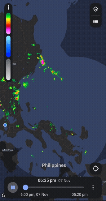
The small island, Polillo looks like it will get a major hit.
https://x.com/PIADesk/status/1987386271476686912
https://x.com/PIADesk/status/1987386271476686912
0 likes
Re: WPAC: FUNG-WONG - SuperTyphoon - Discussion
Eye is really tightening up with a hot-tower firing off.
All just before landfall
All just before landfall
1 likes
-
mrbagyo

- Category 5

- Posts: 3994
- Age: 33
- Joined: Thu Apr 12, 2012 9:18 am
- Location: 14.13N 120.98E
- Contact:
Re: WPAC: FUNG-WONG - SuperTyphoon - Discussion
2 likes
The posts in this forum are NOT official forecast and should not be used as such. They are just the opinion of the poster and may or may not be backed by sound meteorological data. They are NOT endorsed by any professional institution or storm2k.org. For official information, please refer to RSMC, NHC and NWS products.
Re: WPAC: FUNG-WONG - SuperTyphoon - Discussion
TROPICAL CYCLONE BULLETIN NR. 12
Super Typhoon UWAN (FUNG-WONG)
Issued at 5:00 PM, 09 November 2025
Valid for broadcast until the next bulletin at 8:00 PM today.
LIFE-THREATENING CONDITIONS CONTINUE OVER CAMARINES NORTE AS “UWAN” CONTINUES TO MOVE WEST NORTHWESTWARD AND THREATEN AURORA AND POLILLO ISLANDS.
DOST-PAGASA
https://www.pagasa.dost.gov.ph/tropical ... r-bulletin
https://x.com/dost_pagasa/status/1987446510401851739
0 likes
Re: WPAC: FUNG-WONG - SuperTyphoon - Discussion
UPDATE: With only a few hours left before landfall in Luzon, colossal Typhoon Fung-wong (UwanPH) has hit a new peak intensity. Her sustained winds are now at 130 MPH (210 kph), and the sea-level pressure in her giant eye has fallen to 943 mbar, making her a CATEGORY 4 storm.
This will be the strongest Typhoon to hit the Philippines since Man-yi (Pepito) in November of last year, and is coming just 5 days after Kalmaegi (Tino) ravaged Cebu Island.
https://x.com/BackpirchCrew/status/1987445224537247819
This will be the strongest Typhoon to hit the Philippines since Man-yi (Pepito) in November of last year, and is coming just 5 days after Kalmaegi (Tino) ravaged Cebu Island.
https://x.com/BackpirchCrew/status/1987445224537247819
0 likes
Re: WPAC: FUNG-WONG - SuperTyphoon - Discussion
This maybe a mid to high-end cat4 at landfall
ADT currently has
CI# /Pressure/ Vmax
6.3 / 931.6mb/122.2kt
ADT currently has
CI# /Pressure/ Vmax
6.3 / 931.6mb/122.2kt
0 likes
Re: WPAC: FUNG-WONG - SuperTyphoon - Discussion
Looks like Jordan Hall will be at the point of landfall or very close.
https://x.com/JordanHallWX/status/1987440276168950236
https://x.com/JordanHallWX/status/1987440276168950236
0 likes
-
mrbagyo
- Category 5
- Posts: 3994
- Age: 33
- Joined: Thu Apr 12, 2012 9:18 am
- Location: 14.13N 120.98E
- Contact:
Re: WPAC: FUNG-WONG - Typhoon - Discussion
0 likes
The posts in this forum are NOT official forecast and should not be used as such. They are just the opinion of the poster and may or may not be backed by sound meteorological data. They are NOT endorsed by any professional institution or storm2k.org. For official information, please refer to RSMC, NHC and NWS products.

Re: WPAC: FUNG-WONG - Typhoon - Discussion
Baler 1200 synop reporting 18 m/s wind speed from west, 961.9mb mslp with 3hr 19mb pressure drop, 24hr 44.7mb pressure drop and gust 33 m/s
SMPH20 RPUR
091200
AAXX 09121 98334 11410 82718 10/// 20/// 39426 49619 57190 60621 76566 8472/ 333 10255 56999 59447 84715 88457= qnt 33mps ec
091200
AAXX 09121 98334 11410 82718 10/// 20/// 39426 49619 57190 60621 76566 8472/ 333 10255 56999 59447 84715 88457= qnt 33mps ec
0 likes
ヤンデレ女が寝取られるているのを見たい!!!
ECMWF ensemble NWPAC plots: https://ecmwfensnwpac.imgbb.com/
Multimodel NWPAC plots: https://multimodelnwpac.imgbb.com/
GFS Ensemble NWPAC plots (16 & 35 day forecast): https://gefsnwpac.imgbb.com/
Plots updated automatically
ECMWF ensemble NWPAC plots: https://ecmwfensnwpac.imgbb.com/
Multimodel NWPAC plots: https://multimodelnwpac.imgbb.com/
GFS Ensemble NWPAC plots (16 & 35 day forecast): https://gefsnwpac.imgbb.com/
Plots updated automatically
Re: WPAC: FUNG-WONG - Typhoon - Discussion
TROPICAL CYCLONE BULLETIN NR. 13
Super Typhoon #UwanPH (FUNG-WONG)
Issued at 8:00 PM, 09 November 2025
Valid for broadcast until the next bulletin at 11:00 PM today.
SUPER TYPHOON “UWAN” IS ABOUT TO MAKE LANDFALL OVER THE CENTRAL OR NORTHERN PORTION OF AURORA
https://www.pagasa.dost.gov.ph/tropical ... r-bulletin
https://x.com/dost_pagasa/status/1987495597461712978
0 likes
-
mrbagyo
- Category 5
- Posts: 3994
- Age: 33
- Joined: Thu Apr 12, 2012 9:18 am
- Location: 14.13N 120.98E
- Contact:
Re: WPAC: FUNG-WONG - Typhoon - Discussion
https://x.com/JordanHallWX/status/1987456713575092599
They nailed the eye in Dinadiawan
https://twitter.com/JordanHallWX/status/1987503633588756969
Massive surge in their location
https://twitter.com/JordanHallWX/status/1987506956282798336
https://twitter.com/OreboundImages/status/1987506667299496338
They nailed the eye in Dinadiawan
https://twitter.com/JordanHallWX/status/1987503633588756969
Massive surge in their location
https://twitter.com/JordanHallWX/status/1987506956282798336
https://twitter.com/OreboundImages/status/1987506667299496338
Last edited by mrbagyo on Sun Nov 09, 2025 8:12 am, edited 2 times in total.
0 likes
The posts in this forum are NOT official forecast and should not be used as such. They are just the opinion of the poster and may or may not be backed by sound meteorological data. They are NOT endorsed by any professional institution or storm2k.org. For official information, please refer to RSMC, NHC and NWS products.
Re: WPAC: FUNG-WONG - Typhoon - Discussion
Baler 1300, 18m/s, 960.4mb mslp, 40m/s gust
SNPH20 RPUR
091300
AAXX 09131 98334 41440 82718 10/// 20/// 39412 49604 5//// 76166 8372/ 333 56999 83715 88457= qnt 40mps ec
091300
AAXX 09131 98334 41440 82718 10/// 20/// 39412 49604 5//// 76166 8372/ 333 56999 83715 88457= qnt 40mps ec
0 likes
ヤンデレ女が寝取られるているのを見たい!!!
ECMWF ensemble NWPAC plots: https://ecmwfensnwpac.imgbb.com/
Multimodel NWPAC plots: https://multimodelnwpac.imgbb.com/
GFS Ensemble NWPAC plots (16 & 35 day forecast): https://gefsnwpac.imgbb.com/
Plots updated automatically
ECMWF ensemble NWPAC plots: https://ecmwfensnwpac.imgbb.com/
Multimodel NWPAC plots: https://multimodelnwpac.imgbb.com/
GFS Ensemble NWPAC plots (16 & 35 day forecast): https://gefsnwpac.imgbb.com/
Plots updated automatically
-
mrbagyo
- Category 5
- Posts: 3994
- Age: 33
- Joined: Thu Apr 12, 2012 9:18 am
- Location: 14.13N 120.98E
- Contact:
Re: WPAC: FUNG-WONG - Typhoon - Discussion
Hayabusa wrote:Baler 1300, 18m/s, 960.4mb mslp, 40m/s gustSNPH20 RPUR
091300
AAXX 09131 98334 41440 82718 10/// 20/// 39412 49604 5//// 76166 8372/ 333 56999 83715 88457= qnt 40mps ec
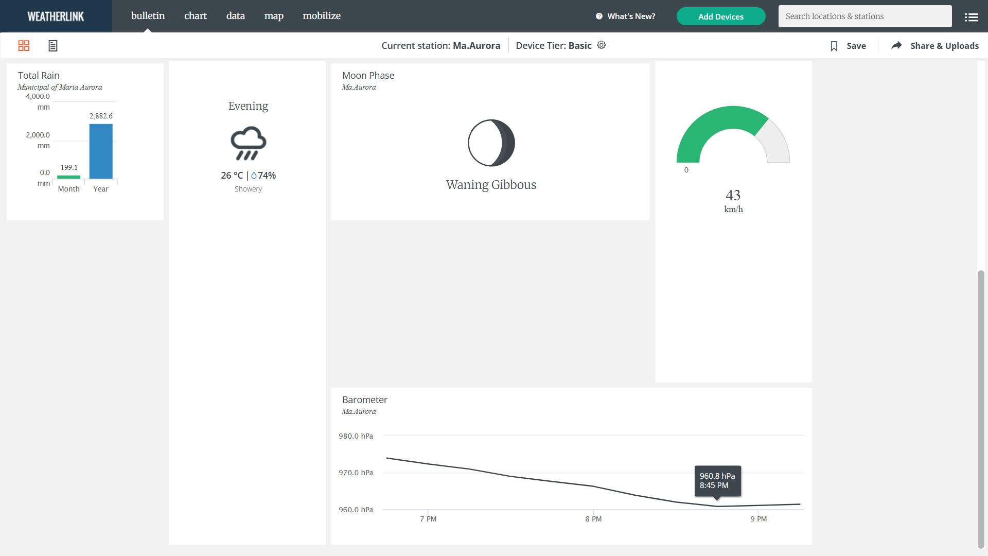
Davis vantage AWS in Maria Aurora bottomed out at 960.8 hPa
https://www.weatherlink.com/map/shared/MkEi9GQzcv7OyehqHkRBvZuY3jm0fmmr
0 likes
The posts in this forum are NOT official forecast and should not be used as such. They are just the opinion of the poster and may or may not be backed by sound meteorological data. They are NOT endorsed by any professional institution or storm2k.org. For official information, please refer to RSMC, NHC and NWS products.
-
mrbagyo
- Category 5
- Posts: 3994
- Age: 33
- Joined: Thu Apr 12, 2012 9:18 am
- Location: 14.13N 120.98E
- Contact:
Re: WPAC: FUNG-WONG - Typhoon - Discussion
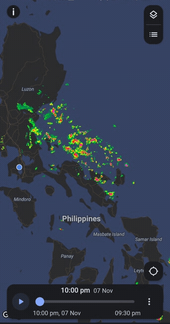
Landfall
0 likes
The posts in this forum are NOT official forecast and should not be used as such. They are just the opinion of the poster and may or may not be backed by sound meteorological data. They are NOT endorsed by any professional institution or storm2k.org. For official information, please refer to RSMC, NHC and NWS products.
Who is online
Users browsing this forum: No registered users and 89 guests