WPAC: SINLAKU - Typhoon

Detailed discussion and tracking of all WestPac basin storms with special input from staff of our partner site, WesternPacificWeather

Moderators: S2k Moderators, WesternPacificWeatherMods

Forum rules

The posts in this forum are NOT official forecast and should not be used as such. They are just the opinion of the poster and may or may not be backed by sound meteorological data. They are NOT endorsed by any professional institution or STORM2K.

Help Support Storm2K
Message
Author
User avatar
doomhaMwx
Category 5
Category 5
Posts: 2493
Age: 27
Joined: Tue Apr 18, 2017 4:01 am
Location: Baguio/Benguet, Philippines
Contact:

Re: WPAC: SINLAKU - Typhoon

#221 Postby doomhaMwx » Mon Apr 13, 2026 8:41 am

3 likes   

User avatar
cycloneye
Admin
Admin
Posts: 149686
Age: 69
Joined: Thu Oct 10, 2002 10:54 am
Location: San Juan, Puerto Rico

Re: WPAC: SINLAKU - Typhoon

#222 Postby cycloneye » Mon Apr 13, 2026 9:11 am

0 likes   
Visit the Caribbean-Central America Weather Thread where you can find at first post web cams,radars
and observations from Caribbean basin members Click Here

User avatar
cycloneye
Admin
Admin
Posts: 149686
Age: 69
Joined: Thu Oct 10, 2002 10:54 am
Location: San Juan, Puerto Rico

Re: WPAC: SINLAKU - Typhoon

#223 Postby cycloneye » Mon Apr 13, 2026 9:58 am

Tianan and Saipan will get the worse conditions in a few hours.

https://www.earthcam.com/world/northern ... cam=saipan

Image
0 likes   
Visit the Caribbean-Central America Weather Thread where you can find at first post web cams,radars
and observations from Caribbean basin members Click Here

User avatar
cycloneye
Admin
Admin
Posts: 149686
Age: 69
Joined: Thu Oct 10, 2002 10:54 am
Location: San Juan, Puerto Rico

Re: WPAC: SINLAKU - Typhoon

#224 Postby cycloneye » Mon Apr 13, 2026 10:43 am

0 likes   
Visit the Caribbean-Central America Weather Thread where you can find at first post web cams,radars
and observations from Caribbean basin members Click Here

User avatar
sasha_B
Category 1
Category 1
Posts: 375
Age: 25
Joined: Sun Jun 30, 2024 4:32 pm
Location: Charleston, SC

Re: WPAC: SINLAKU - Typhoon

#225 Postby sasha_B » Mon Apr 13, 2026 11:23 am

CDO seems to be shrinking and warming more rapidly now than it was overnight, though it'll be a while yet before this gets below T7.0 - there's still a rather impressive outer band & a very warm eye. My guess is it'll be down to 145 kt / 908 hPa by 0z, but they might decide to hold intensity for the 18z best track update.

MSLP is down to 992.9 hPa at PGSN and 993.7 hPa at PGUM, as of 16z. Will be interesting to see what kind of data they record when Sinlaku makes its closest approach.
0 likes   

ljmac75
Tropical Storm
Tropical Storm
Posts: 232
Joined: Fri Apr 28, 2023 12:30 am

Re: WPAC: SINLAKU - Typhoon

#226 Postby ljmac75 » Mon Apr 13, 2026 11:42 am

Kinda looked like it was doing an ERC on radar earlier but now I'm not so sure. Maybe it's been trained by Melissa in the art of not undergoing full ERCs.
2 likes   

User avatar
cycloneye
Admin
Admin
Posts: 149686
Age: 69
Joined: Thu Oct 10, 2002 10:54 am
Location: San Juan, Puerto Rico

Re: WPAC: SINLAKU - Typhoon

#227 Postby cycloneye » Mon Apr 13, 2026 12:15 pm

For sure Sinkalu will be subject to many studies and analysis by the experts, especially in terms of the lack of ERCs.
3 likes   
Visit the Caribbean-Central America Weather Thread where you can find at first post web cams,radars
and observations from Caribbean basin members Click Here

User avatar
MGC
S2K Supporter
S2K Supporter
Posts: 5941
Joined: Sun Mar 23, 2003 9:05 pm
Location: Pass Christian MS, or what is left.

2026 WPAC Season

#228 Postby MGC » Mon Apr 13, 2026 1:42 pm

Saipan and Tinian need to batten down the hatches. Guam should miss the worst of it with Rota getting a glancing blow. Impressive typhoon.......MGC
0 likes   

User avatar
Hurricane2022
Category 5
Category 5
Posts: 2090
Joined: Tue Aug 23, 2022 11:38 pm
Location: Araçatuba, Brazil

Re: WPAC: SINLAKU - Typhoon

#229 Postby Hurricane2022 » Mon Apr 13, 2026 1:56 pm

1 likes   
Sorry for the bad English sometimes...!
For reliable and detailed information for any meteorological phenomenon, please consult the National Hurricane Center, Joint Typhoon Warning Center , or your local Meteo Center.

--------

ECCE OMNIA NOVA FACIAM (Ap 21,5).

User avatar
cycloneye
Admin
Admin
Posts: 149686
Age: 69
Joined: Thu Oct 10, 2002 10:54 am
Location: San Juan, Puerto Rico

Re: 2026 WPAC Season

#230 Postby cycloneye » Mon Apr 13, 2026 3:27 pm

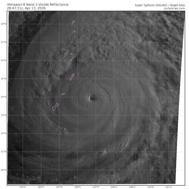
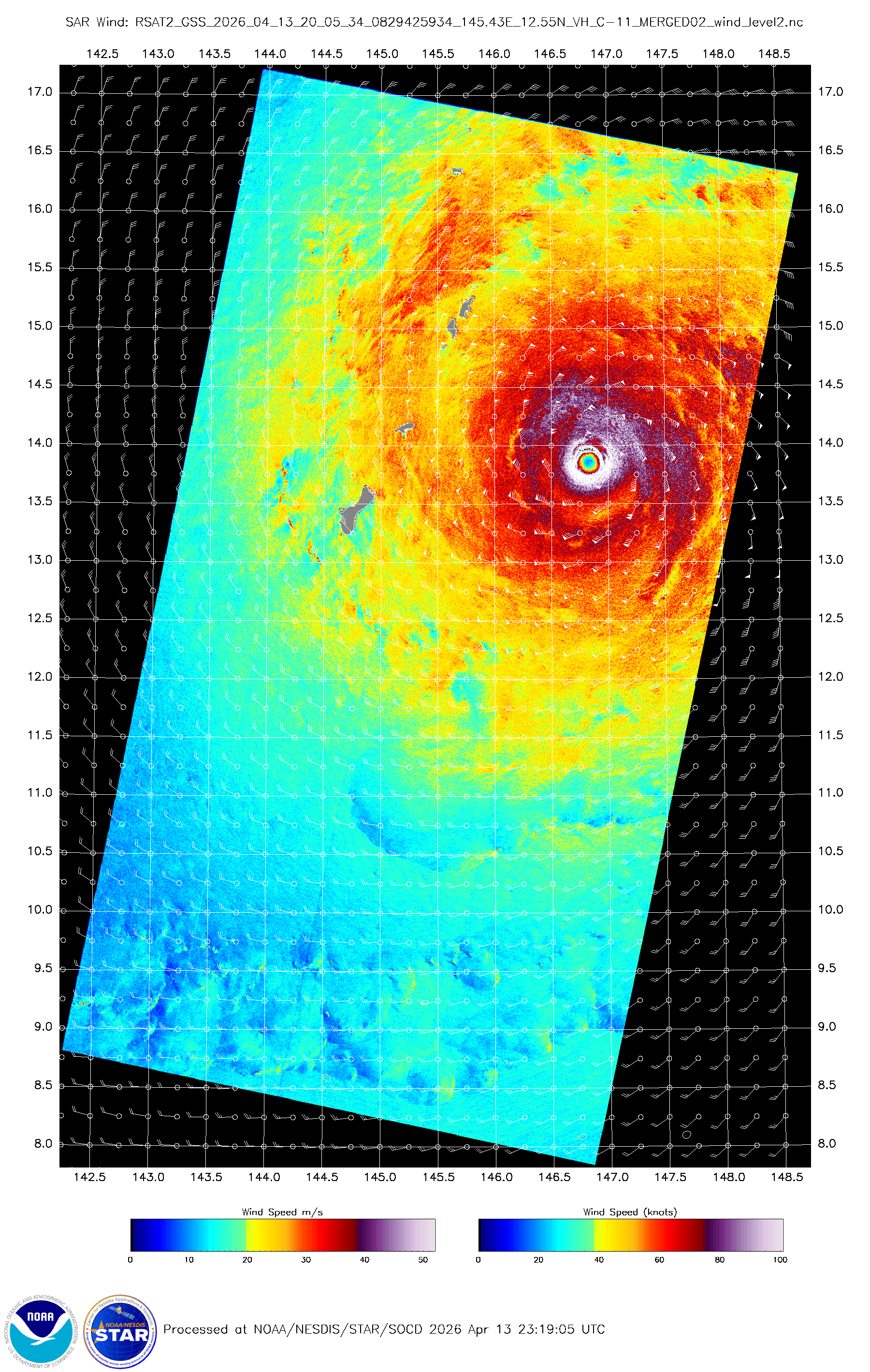
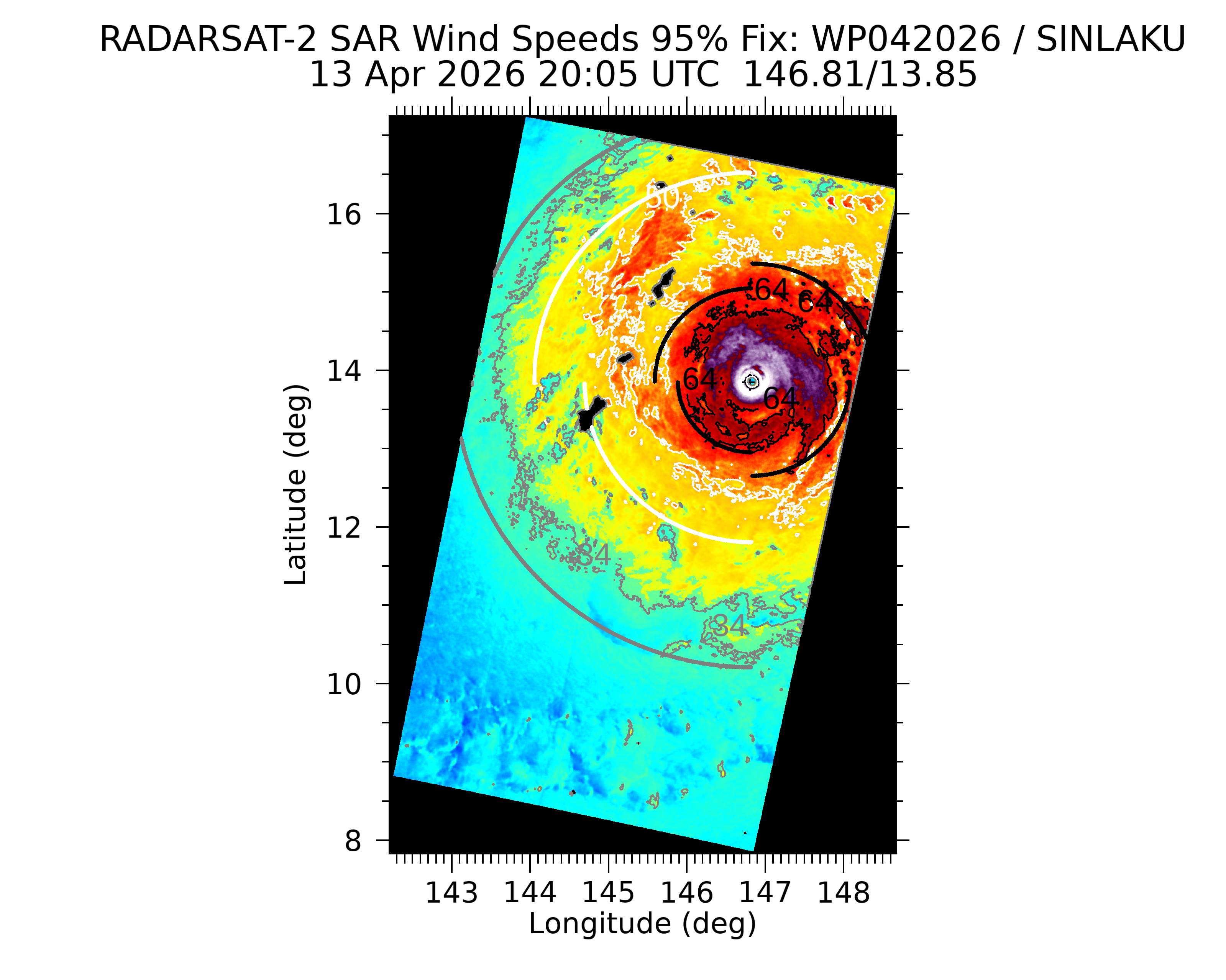
MGC wrote:Saipan and Tinian need to batten down the hatches. Guam should miss the worst of it with Rota getting a glancing blow. Impressive typhoon.......MGC


To let you know that moved your post from the WPAC thread to here.
1 likes   
Visit the Caribbean-Central America Weather Thread where you can find at first post web cams,radars
and observations from Caribbean basin members Click Here

User avatar
sasha_B
Category 1
Category 1
Posts: 375
Age: 25
Joined: Sun Jun 30, 2024 4:32 pm
Location: Charleston, SC

Re: WPAC: SINLAKU - Typhoon

#231 Postby sasha_B » Mon Apr 13, 2026 3:58 pm

Subjective DT still supports FT7.0 / CI 7.5, though barely - 6.5/7.0 might be more appropriate. ADT stands at 6.9/7.3. On the whole I think 145 kt and 900~910 kt is a decent estimate of current intensity (CKZ gives 904 hPa using the JTWC's 21z update's parameters, or 908 hPa using ADT's parameters and max wind speeds of 145 kt).

Pressure is down to 987 hPa at PGSN as the typhoon continues its approach.
0 likes   

User avatar
mrbagyo
Category 5
Category 5
Posts: 3988
Age: 33
Joined: Thu Apr 12, 2012 9:18 am
Location: 14.13N 120.98E
Contact:

Re: WPAC: SINLAKU - Typhoon

#232 Postby mrbagyo » Mon Apr 13, 2026 4:49 pm

0 likes   
The posts in this forum are NOT official forecast and should not be used as such. They are just the opinion of the poster and may or may not be backed by sound meteorological data. They are NOT endorsed by any professional institution or storm2k.org. For official information, please refer to RSMC, NHC and NWS products.

User avatar
DorkyMcDorkface
Category 5
Category 5
Posts: 1039
Age: 28
Joined: Mon Sep 30, 2019 1:32 pm
Location: Mid-Atlantic

Re: WPAC: SINLAKU - Typhoon

#233 Postby DorkyMcDorkface » Mon Apr 13, 2026 5:13 pm

Image
3 likes   
Please note the thoughts expressed by this account are solely those of the user and are from a hobbyist perspective. For more comprehensive analysis, consult an actual professional meteorologist or meteorological agency.


Floyd 1999 | Isabel 2003 | Hanna 2008 | Irene 2011 | Sandy 2012 | Isaias 2020

User avatar
cycloneye
Admin
Admin
Posts: 149686
Age: 69
Joined: Thu Oct 10, 2002 10:54 am
Location: San Juan, Puerto Rico

Re: WPAC: SINLAKU - Typhoon

#234 Postby cycloneye » Mon Apr 13, 2026 5:16 pm

This is me posting at X. :D Translation to english.

Super Typhoon Sinlaku weakens a bit but continues to be category 5 with winds of 165 mph as it approaches Saipan in the Mariana Islands. See what the conditions are like in Saipan in the link to web cam.

https://www.earthcam.com/world/northern ... cam=saipan

 https://x.com/CycloforumsPR/status/2043811762013716675

1 likes   
Visit the Caribbean-Central America Weather Thread where you can find at first post web cams,radars
and observations from Caribbean basin members Click Here

User avatar
cycloneye
Admin
Admin
Posts: 149686
Age: 69
Joined: Thu Oct 10, 2002 10:54 am
Location: San Juan, Puerto Rico

Re: WPAC: SINLAKU - Typhoon

#235 Postby cycloneye » Mon Apr 13, 2026 6:25 pm

1 likes   
Visit the Caribbean-Central America Weather Thread where you can find at first post web cams,radars
and observations from Caribbean basin members Click Here

ljmac75
Tropical Storm
Tropical Storm
Posts: 232
Joined: Fri Apr 28, 2023 12:30 am

Re: WPAC: SINLAKU - Typhoon

#236 Postby ljmac75 » Mon Apr 13, 2026 7:22 pm

It's a testament to what a storm this was at peak that it's got a beautiful eye and an great satellite presentation and we're still all like "wow it's degraded quite a bit."
2 likes   

User avatar
mrbagyo
Category 5
Category 5
Posts: 3988
Age: 33
Joined: Thu Apr 12, 2012 9:18 am
Location: 14.13N 120.98E
Contact:

Re: WPAC: SINLAKU - Typhoon

#237 Postby mrbagyo » Mon Apr 13, 2026 7:58 pm

Pressure in Saipan Intl Airport is down to 979 hPa
PGSN 140046Z AUTO 03046G70KT 3/4SM RA BR BKN010 OVC016 26/25 A2891 RMK AO2 PK WND 03083/0012 PRESFR P0010 T02560250 TSNO $

And we got another SAR pass.
Looks like there are 3 peaks with the outermost at 30-40 nmi from the center


Image
Image
Image
1 likes   
The posts in this forum are NOT official forecast and should not be used as such. They are just the opinion of the poster and may or may not be backed by sound meteorological data. They are NOT endorsed by any professional institution or storm2k.org. For official information, please refer to RSMC, NHC and NWS products.

User avatar
cycloneye
Admin
Admin
Posts: 149686
Age: 69
Joined: Thu Oct 10, 2002 10:54 am
Location: San Juan, Puerto Rico

Re: WPAC: SINLAKU - Typhoon

#238 Postby cycloneye » Mon Apr 13, 2026 8:05 pm

Down to 135 kt.

04W SINLAKU 260414 0000 14.3N 146.5E WPAC 135 919
1 likes   
Visit the Caribbean-Central America Weather Thread where you can find at first post web cams,radars
and observations from Caribbean basin members Click Here

User avatar
sasha_B
Category 1
Category 1
Posts: 375
Age: 25
Joined: Sun Jun 30, 2024 4:32 pm
Location: Charleston, SC

Re: WPAC: SINLAKU - Typhoon

#239 Postby sasha_B » Mon Apr 13, 2026 8:15 pm

The JTWC's downgrade to 135 kt / 919 hPa for 0000z is a little more aggressive than I expected, but makes sense given how dramatic Sinlaku's deterioration has been. If the trend continues, it'll be at that intensity or lower by 0600z. This eyewall replacement cycle appears to be taking quite a toll (I say, of a storm that still has a 17~18°C eye surrounded by cloud tops <-70°C :lol:).
0 likes   

User avatar
Hurricane2022
Category 5
Category 5
Posts: 2090
Joined: Tue Aug 23, 2022 11:38 pm
Location: Araçatuba, Brazil

Re: WPAC: SINLAKU - Typhoon

#240 Postby Hurricane2022 » Mon Apr 13, 2026 8:30 pm

Image
2 likes   
Sorry for the bad English sometimes...!
For reliable and detailed information for any meteorological phenomenon, please consult the National Hurricane Center, Joint Typhoon Warning Center , or your local Meteo Center.

--------

ECCE OMNIA NOVA FACIAM (Ap 21,5).


Return to “Active Storms - WestPAC/Asia”

Who is online

Users browsing this forum: No registered users and 66 guests