Invest 95L,Comments,Sat Pics,Models Thread

This is the general tropical discussion area. Anyone can take their shot at predicting a storms path.

Moderator: S2k Moderators

Forum rules

The posts in this forum are NOT official forecasts and should not be used as such. They are just the opinion of the poster and may or may not be backed by sound meteorological data. They are NOT endorsed by any professional institution or STORM2K. For official information, please refer to products from the National Hurricane Center and National Weather Service.

Help Support Storm2K
Message
Author
User avatar
HURAKAN
Professional-Met
Professional-Met
Posts: 46086
Age: 38
Joined: Thu May 20, 2004 4:34 pm
Location: Key West, FL
Contact:

#221 Postby HURAKAN » Thu Sep 15, 2005 10:58 am

Image

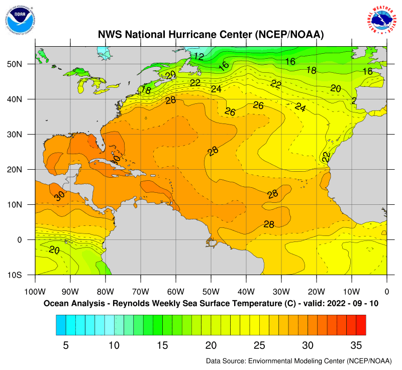
That's what I would call "HOT WATER" 30º Celcius (86º F).
0 likes   

User avatar
Recurve
Category 5
Category 5
Posts: 1640
Joined: Tue Aug 16, 2005 8:59 pm
Location: St. Petersburg, FL

#222 Postby Recurve » Thu Sep 15, 2005 11:46 am

Oh please, not the BAMM.
Do not like to see long trackers slide just north of Hispanola. But then south is bad for the Gulf and they don't need anyting else for years.
0 likes   

User avatar
cycloneye
Admin
Admin
Posts: 148497
Age: 69
Joined: Thu Oct 10, 2002 10:54 am
Location: San Juan, Puerto Rico

#223 Postby cycloneye » Thu Sep 15, 2005 11:48 am

PROBABLE 12-HRLY FIXES BEGINNING AT 17/1800Z
OF A DEVELOPING SYSTEM NEAR 11.5N 58.0W.
0 likes   
Visit the Caribbean-Central America Weather Thread where you can find at first post web cams,radars
and observations from Caribbean basin members Click Here

User avatar
cjrciadt
S2K Supporter
S2K Supporter
Posts: 1616
Joined: Mon Aug 22, 2005 1:11 pm
Location: Kissimmee, FL

#224 Postby cjrciadt » Thu Sep 15, 2005 11:51 am

"Possible" intensity forecasts
Image
0 likes   

PuertoRicoLibre
Tropical Depression
Tropical Depression
Posts: 68
Joined: Thu Sep 04, 2003 2:38 pm

#225 Postby PuertoRicoLibre » Thu Sep 15, 2005 11:54 am

58W???? That is really bad news for the Caribbean.
0 likes   

Brent
S2K Supporter
S2K Supporter
Posts: 38265
Age: 37
Joined: Sun May 16, 2004 10:30 pm
Location: Tulsa Oklahoma
Contact:

#226 Postby Brent » Thu Sep 15, 2005 11:55 am

PuertoRicoLibre wrote:58W???? That is really bad news for the Caribbean.


That's where it's forecast to be Saturday... looks like an Emily or Ivan-type track(at least initially).
0 likes   
#neversummer

scostorms
Tropical Storm
Tropical Storm
Posts: 225
Joined: Mon Aug 29, 2005 8:56 pm
Location: Topeka, Kansas
Contact:

#227 Postby scostorms » Thu Sep 15, 2005 12:00 pm

Eeek. What depression are we coming up to, 12?
0 likes   

User avatar
cycloneye
Admin
Admin
Posts: 148497
Age: 69
Joined: Thu Oct 10, 2002 10:54 am
Location: San Juan, Puerto Rico

#228 Postby cycloneye » Thu Sep 15, 2005 12:01 pm

scostorms wrote:Eeek. What depression are we coming up to, 12?


If it forms into a TD it would be TD17.
0 likes   
Visit the Caribbean-Central America Weather Thread where you can find at first post web cams,radars
and observations from Caribbean basin members Click Here

Brent
S2K Supporter
S2K Supporter
Posts: 38265
Age: 37
Joined: Sun May 16, 2004 10:30 pm
Location: Tulsa Oklahoma
Contact:

#229 Postby Brent » Thu Sep 15, 2005 12:03 pm

Yep... Ophelia was 16. :eek:
0 likes   
#neversummer

clfenwi
Category 5
Category 5
Posts: 3331
Joined: Thu Jun 09, 2005 12:54 pm

#230 Postby clfenwi » Thu Sep 15, 2005 12:43 pm

First GFDL run that doesn't kill off the system:

WHXX04 KWBC 151723
CHGQLM
ATTENTION...NATIONAL HURRICANE CENTER

NCEP UNCOUPLED GFDL HURRICANE MODEL FORECAST MADE FOR

TROPICAL DEPRESSION INVEST 95L

INITIAL TIME 12Z SEP 15

DISCLAIMER ... THIS INFORMATION IS PROVIDED AS GUIDANCE. IT
REQUIRES INTERPRETATION BY HURRICANE SPECIALISTS AND SHOULD
NOT BE CONSIDERED AS A FINAL PRODUCT. PLEASE SEE THE TPC/NHC
OFFICIAL FORECAST.


FORECAST STORM POSITION

HOUR LATITUDE LONGITUDE HEADING/SPEED(KT)

0 9.6 46.5 272./11.1
6 10.2 46.8 332./ 7.6
12 11.1 48.1 304./15.9
18 12.1 48.9 319./11.9
24 13.0 49.7 320./12.1
30 13.9 50.2 333./10.2
36 14.4 51.1 300./10.0
42 15.2 51.4 337./ 8.2
48 15.8 52.1 310./ 9.5
54 16.2 52.3 337./ 4.6
60 17.2 52.5 352./ 9.6
66 17.6 52.8 322./ 5.1
72 18.0 52.9 346./ 4.2
78 18.6 52.8 8./ 5.8
84 19.2 52.8 355./ 6.0
90 19.9 53.2 338./ 8.1
96 21.0 53.5 341./10.8
102 21.9 54.0 332./10.7
108 22.9 54.5 336./10.6
114 23.8 55.0 329./10.5
120 24.6 55.6 326./ 9.7
126 25.6 56.0 336./10.0
0 likes   

User avatar
MortisFL
Category 1
Category 1
Posts: 391
Age: 42
Joined: Mon Jul 21, 2003 9:01 am
Location: Sarasota, FL
Contact:

#231 Postby MortisFL » Thu Sep 15, 2005 12:48 pm

way north...


clfenwi wrote:First GFDL run that doesn't kill off the system:

WHXX04 KWBC 151723
CHGQLM
ATTENTION...NATIONAL HURRICANE CENTER

NCEP UNCOUPLED GFDL HURRICANE MODEL FORECAST MADE FOR

TROPICAL DEPRESSION INVEST 95L

INITIAL TIME 12Z SEP 15

DISCLAIMER ... THIS INFORMATION IS PROVIDED AS GUIDANCE. IT
REQUIRES INTERPRETATION BY HURRICANE SPECIALISTS AND SHOULD
NOT BE CONSIDERED AS A FINAL PRODUCT. PLEASE SEE THE TPC/NHC
OFFICIAL FORECAST.


FORECAST STORM POSITION

HOUR LATITUDE LONGITUDE HEADING/SPEED(KT)

0 9.6 46.5 272./11.1
6 10.2 46.8 332./ 7.6
12 11.1 48.1 304./15.9
18 12.1 48.9 319./11.9
24 13.0 49.7 320./12.1
30 13.9 50.2 333./10.2
36 14.4 51.1 300./10.0
42 15.2 51.4 337./ 8.2
48 15.8 52.1 310./ 9.5
54 16.2 52.3 337./ 4.6
60 17.2 52.5 352./ 9.6
66 17.6 52.8 322./ 5.1
72 18.0 52.9 346./ 4.2
78 18.6 52.8 8./ 5.8
84 19.2 52.8 355./ 6.0
90 19.9 53.2 338./ 8.1
96 21.0 53.5 341./10.8
102 21.9 54.0 332./10.7
108 22.9 54.5 336./10.6
114 23.8 55.0 329./10.5
120 24.6 55.6 326./ 9.7
126 25.6 56.0 336./10.0
0 likes   

User avatar
gtalum
S2K Supporter
S2K Supporter
Posts: 4749
Age: 49
Joined: Tue Sep 07, 2004 3:48 pm
Location: Bradenton, FL
Contact:

#232 Postby gtalum » Thu Sep 15, 2005 12:48 pm

GFDL and UKMET show the storm moving NNW. But they both seem to have initialized too far north (especially UKMET!).
0 likes   

User avatar
cinlfla
Category 2
Category 2
Posts: 687
Joined: Mon Aug 16, 2004 7:16 pm
Location: Titusville, Florida on the Spacecoast

#233 Postby cinlfla » Thu Sep 15, 2005 1:13 pm

Oh yeah.....The gfdl and the ukmet are both to far north with 95l even if the position was right that have it moving north like now, and I just don't see it.
0 likes   

CHRISTY

i think the wave near puerto is somethig to watch!

#234 Postby CHRISTY » Thu Sep 15, 2005 1:17 pm

this wave near puerto rico is flaring up today ! do any models show this wave developeing into a storm?
0 likes   

User avatar
cinlfla
Category 2
Category 2
Posts: 687
Joined: Mon Aug 16, 2004 7:16 pm
Location: Titusville, Florida on the Spacecoast

#235 Postby cinlfla » Thu Sep 15, 2005 1:19 pm

this wave near puerto rico is flaring up today ! do any models show this wave developeing into a storm?


I'm not sure about it being a depression or anything but it looks like some of the models send a low to south florida. There is a thread here about the CMC model and the wave near PR.

http://www.storm2k.org/phpbb2/viewtopic.php?t=74378
0 likes   

User avatar
cycloneye
Admin
Admin
Posts: 148497
Age: 69
Joined: Thu Oct 10, 2002 10:54 am
Location: San Juan, Puerto Rico

#236 Postby cycloneye » Thu Sep 15, 2005 1:24 pm

15/1745 UTC 9.4N 47.4W T1.0/1.0 95 -- Atlantic Ocean


Latest SSD Dvorak T numbers this afternoon dont support TD status.

No TD at 5 PM nor at 11 PM unless it organizes quickly as it's taking it's time doing so.
0 likes   
Visit the Caribbean-Central America Weather Thread where you can find at first post web cams,radars
and observations from Caribbean basin members Click Here

Brent
S2K Supporter
S2K Supporter
Posts: 38265
Age: 37
Joined: Sun May 16, 2004 10:30 pm
Location: Tulsa Oklahoma
Contact:

#237 Postby Brent » Thu Sep 15, 2005 1:28 pm

Yeah... the satellite imagery doesn't look quite as impressive either.
0 likes   
#neversummer

clfenwi
Category 5
Category 5
Posts: 3331
Joined: Thu Jun 09, 2005 12:54 pm

#238 Postby clfenwi » Thu Sep 15, 2005 1:33 pm

WHXX01 KWBC 151829
CHGHUR

DISCLAIMER...NUMERICAL MODELS ARE SUBJECT TO LARGE ERRORS.
PLEASE REFER TO TPC/NHC OFFICIAL FORECASTS FOR TROPICAL CYCLONES.

NATIONAL HURRICANE CENTER NORTH ATLANTIC OBJECTIVE AIDS FOR

TROPICAL DEPRESSION INVEST (AL952005) ON 20050915 1800 UTC

...00 HRS... ...12 HRS... ...24 HRS... ...36 HRS...
050915 1800 050916 0600 050916 1800 050917 0600

LAT LON LAT LON LAT LON LAT LON
BAMD 9.3N 47.7W 9.6N 50.5W 9.9N 52.8W 10.4N 54.7W
BAMM 9.3N 47.7W 10.1N 49.9W 11.0N 51.8W 11.9N 53.2W
A98E 9.3N 47.7W 9.5N 50.0W 9.8N 52.4W 9.9N 54.7W
LBAR 9.3N 47.7W 9.8N 50.2W 10.5N 52.8W 11.4N 55.4W
SHIP 25KTS 30KTS 36KTS 44KTS
DSHP 25KTS 30KTS 36KTS 44KTS

...48 HRS... ...72 HRS... ...96 HRS... ..120 HRS...
050917 1800 050918 1800 050919 1800 050920 1800

LAT LON LAT LON LAT LON LAT LON
BAMD 10.9N 56.2W 11.4N 58.4W 11.9N 60.7W 13.2N 63.4W
BAMM 12.8N 54.2W 13.6N 55.2W 14.0N 56.5W 14.5N 58.2W
A98E 9.8N 56.7W 10.6N 60.5W 11.3N 64.2W 12.3N 68.0W
LBAR 12.1N 57.8W 13.6N 61.2W 14.5N 63.7W 14.9N 65.8W
SHIP 52KTS 66KTS 77KTS 84KTS
DSHP 52KTS 66KTS 77KTS 84KTS

...INITIAL CONDITIONS...
LATCUR = 9.3N LONCUR = 47.7W DIRCUR = 275DEG SPDCUR = 11KT
LATM12 = 9.1N LONM12 = 45.5W DIRM12 = 275DEG SPDM12 = 11KT
LATM24 = 8.9N LONM24 = 43.3W
WNDCUR = 25KT RMAXWD = 40NM WNDM12 = 25KT
CENPRS = 1010MB OUTPRS = 1013MB OUTRAD = 150NM SDEPTH = D
RD34NE = 0NM RD34SE = 0NM RD34SW = 0NM RD34NW = 0NM

0 likes   

apocalypt-flyer
Category 1
Category 1
Posts: 468
Joined: Sat Aug 27, 2005 11:51 am

#239 Postby apocalypt-flyer » Thu Sep 15, 2005 1:53 pm

This slower it develops the bigger is the chance for a more northern track, isn't it? ..
0 likes   

User avatar
southerngale
Retired Staff
Retired Staff
Posts: 27418
Joined: Thu Oct 10, 2002 1:27 am
Location: Southeast Texas (Beaumont area)

#240 Postby southerngale » Thu Sep 15, 2005 1:54 pm

apocalypt-flyer wrote:This slower it develops the bigger is the chance for a more northern track, isn't it? ..


I think it's just the opposite.
0 likes   
Please support Storm2k by making a donation today. It is greatly appreciated! Click here: Image

Image my Cowboys Image my RocketsImage my Astros


Return to “Talkin' Tropics”

Who is online

Users browsing this forum: Team Ghost and 245 guests