TX Winter Wx Threat # 11-- sleet and snow in a lot of Tx/La
Moderator: S2k Moderators
Forum rules
 The posts in this forum are NOT official forecast and should not be used as such. They are just the opinion of the poster and may or may not be backed by sound meteorological data. They are NOT endorsed by any professional institution or STORM2K.

The posts in this forum are NOT official forecast and should not be used as such. They are just the opinion of the poster and may or may not be backed by sound meteorological data. They are NOT endorsed by any professional institution or STORM2K.
-
Extremeweatherguy

- Category 5

- Posts: 11095
- Joined: Mon Oct 10, 2005 8:13 pm
- Location: Florida

-
Extremeweatherguy
- Category 5
- Posts: 11095
- Joined: Mon Oct 10, 2005 8:13 pm
- Location: Florida
These cells out west showing up as "storms" are actually more likely pockets of sleet. Could get interesting within the next hour...
[web]http://www.weatherunderground.com/radar/radblast.asp?zoommode=zoom&num=6&delay=15&rbscale=0.4369565217391304&scale=1.000&noclutter=0&ID=HGX&type=N0R&lat=0&lon=0&label=you&showstorms=31&map.x=358.5&map.y=211¢erx=400¢ery=240&lightning=1&showlabels=1&rainsnow=0[/web]
[web]http://www.weatherunderground.com/radar/radblast.asp?zoommode=zoom&num=6&delay=15&rbscale=0.4369565217391304&scale=1.000&noclutter=0&ID=HGX&type=N0R&lat=0&lon=0&label=you&showstorms=31&map.x=358.5&map.y=211¢erx=400¢ery=240&lightning=1&showlabels=1&rainsnow=0[/web]
0 likes
-
Extremeweatherguy
- Category 5
- Posts: 11095
- Joined: Mon Oct 10, 2005 8:13 pm
- Location: Florida

-
Extremeweatherguy
- Category 5
- Posts: 11095
- Joined: Mon Oct 10, 2005 8:13 pm
- Location: Florida
The NWS just updated my forecast! Looks like they expect sleet to continue tonight!
Also...a 100% precip. chance? Wow.
BTW: The sleet forecast extends all the way south to IAH!
**Also. Jhonny, you may be in luck! The forecast for Conroe is snow/sleet.***
This Afternoon: Rain likely. Cloudy, with a steady temperature around 43. North wind around 10 mph. Chance of precipitation is 60%.
Tonight: Periods of rain possibly mixed with sleet. Low around 37. North wind between 5 and 10 mph. Chance of precipitation is 100%.
Also...a 100% precip. chance? Wow.
BTW: The sleet forecast extends all the way south to IAH!
**Also. Jhonny, you may be in luck! The forecast for Conroe is snow/sleet.***
0 likes
-
Extremeweatherguy
- Category 5
- Posts: 11095
- Joined: Mon Oct 10, 2005 8:13 pm
- Location: Florida
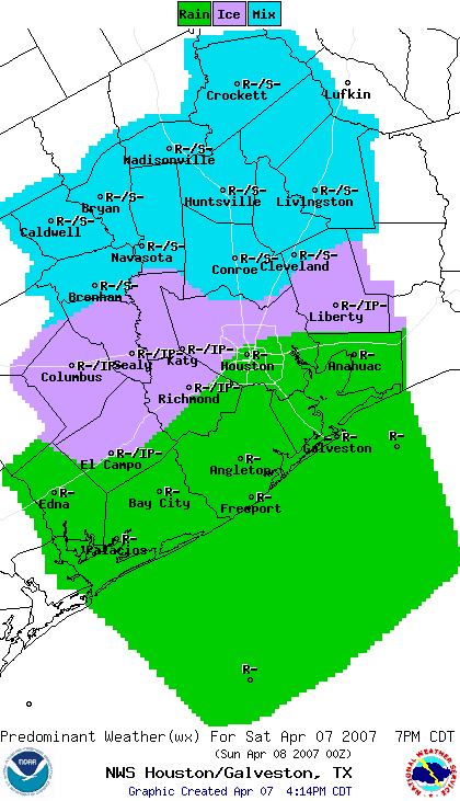
AREA FORECAST DISCUSSION
NATIONAL WEATHER SERVICE HOUSTON/GALVESTON TX
332 PM CDT SAT APR 7 2007
.DISCUSSION...
WHAT A MESS...EXTREME EARLY APRIL WEATHER EVENT ONGOING FOR
SETX WITH A VERY CHILLY AIRMASS OVER THE AREA...AND MIXED
PRECIPITATION!!! AS FAR AS WE HAVE DISCOVERED IN THE RECORDS THIS
IS A REAL RARITY FOR SETX (SINCE 1938) THAT WE HAVE HAD MIXED
PRECIPITATION DURING THE DAY IN IN APRIL.
AS FOR THE FORECAST--MORE OF THE SAME! MAIN UPPER LOW TO CRUISE
INTO THE AREA TONIGHT BRINGING BETTER LIFT WITH SOUNDINGS THAT ARE
SNOW/RAIN/SLEET PROFILES ACROSS THE NORTHERN ZONES AND MIXED
RAIN/SLEET SOUTH...EXCEPT RAIN COAST...AND AMAZINGLY PW VALUES ARE
HOVERING IN THE 0.9 TO 1.1" PW RANGE WITH THAT COLD OF A SOUNDING.
HAVE LOWERED TEMPS TONIGHT ABOUT A DEGREE OR 2 FROM THE PREVIOUS
FORECAST BUT WE SHOULD NOT SEE ANY ACCUMULATIONS OF THE FROZEN
SPECIES. THUNDERSNOW/SLEET IS NOT OUT OF THE QUESTION EITHER.
ACARS SOUNDINGS HAVE BEEN INVALUABLE IN FORECASTING PRECIP TYPES
THIS AFTERNOON. RECEIVED A GREAT PHOTE VIA EMAIL FROM A SPOTTER
IN HUNTSVILLE OF SNOW FALLING. I CAN`T BELIEVE I AM WRITING A
DISCUSSION ABOUT THIS IN APRIL! HEAVIER PRECIP AMOUNTS SHOULD BE
OVER THE CENTRAL AND SOUTHERN PORTIONS OF THE AREA BUT NOT
EXPECTING ANYTHING TO EXCEED AN INCH ALONG THE TAIL END OF THE
UPPER JETS RIGHT ENTRANCE REGION. WILL TRY TO UPDATE THE SPECIAL
WEATHER STATEMENT BEFORE 4 PM. IN ADDITION THE GRADIENT AND STRONG
AIR/SEA THERMAL CONTRAST AND FALLING PRESSURES (RELATIVE TO SETX)
ALONG THE LOWER COAST SHOULD KEEP THE BREEZY/WINDY CONDITIONS IN
PLAY ALONG THE COAST TONIGHT TAPERING OFF AFTER MIDNIGHT. SO FAR
AND AM EXPECTING THEM TO CONTINUE TO FAVOR THE NNE/NE WIND
DIRECTION THIS WILL LEAD TO ELEVATED TIDE LEVELS BY 2-3 FEET BUT
SHOULD REMAIN BELOW CFW ISSUES AT 4.5 FEET MLLW. MWS FOR HIGHER
TIDES WAS JUST UPDATED TO NUDGE DOWN THE EXPECTED TIDE LEVELS. IN
THE EVENT THAT THE COASTAL TROUGH GETS STRONGER OR TUCKED UP IN
CLOSER TO COASTAL BEND REGION THEN WINDS WOULD LIKELY VEER MORE TO
THE ENE-E ALONG THE COAST AND WOULD RAMP UP THE TIDE LEVELS.
FOLLOWING FORECASTS WILL NEED TO KEEP A CLOSE EYE ON THIS.
AFTER THE UPPER WAVE EXITS THE AREA SUNDAY MORNING THE PRECIP-RAIN
SHOULD COME TO AN END BUT SKIES WILL REMAIN CLOUDY FOR A GOOD
PORTION OF THE DAY COURTESY OF THE OVERRUNNING MOISTURE ABOVE THE STRONG
FRONTAL INVERSION. THIS WILL HELP TO BLANKET THE AREA FROM A
PRECIPITOUS DROP IN TEMPERATURES MONDAY MORNING. STRONG WAA GETS
UNDERWAY MONDAY AND TEMPERATURES AND MOISTURE SHOULD BOUNCE BACK.
WILL BE KEEPING 20-30 POPS IN FOR THE WARM FRONTAL PASSAGE MONDAY
AND MONDAY NIGHT THEN A FAST MOVING WEAK PACIFIC FRONTAL SYSTEM
SLIPS INTO THE STATE TUESDAY/WEDNESDAY. AN IMPRESSIVE STORM SYSTEM
TO CRANK UP AS IT TRANSITIONS ACROSS THE SOUTHERN FRONT RANGE
FRIDAY (ECMWF HAS IT STRONGER AND FARTHER SOUTH THAN GFS) DRIVING
A FRONT WITH ABUNDANT MOISTURE INTO SETX FRIDAY
AFTERNOON...CURRENT PROGS INDICATE A LOT OF WIND ENERGY WITH THIS
SYSTEM AND COULD BE A SEVERE EVENT FOR SETX. MORE ON THIS
OBVIOUSLY AS THE SYSTEM NEARS IN TIME.
Thundersnow/sleet...in Texas...in April!!! Is the world ending or what???
0 likes
-
TexasStooge

- Category 5
- Posts: 38127
- Joined: Tue Mar 25, 2003 1:22 pm
- Location: Irving (Dallas County), TX
- Contact:
[font=Arial]There were already a few snow flakes falling in Irving and Burleson, but this event still isn't over. It's expected to taper off by Midday Sunday.
DALLAS/FORT WORTH
Tonight: 35°F
35°F
Easter: 51°F | 41°F
[hr]
WICHITA FALLS
Tonight: 30°F
Easter: 47°F | 37°F
[hr]
ABILENE
Tonight: 29°F
Easter: 43°F | 35°F
[hr]
LUBBOCK
Tonight: 25°F
Easter: 44°F | 36°F
[hr]
AMARILLO
Tonight: 23°F
23°F
Easter: 37°F | 32°F[/font]
DALLAS/FORT WORTH
Tonight:
35°F
Easter:
51°F | 41°F
[hr]
WICHITA FALLS
Tonight:
30°F
Easter:
47°F | 37°F
[hr]
ABILENE
Tonight:
29°F
Easter:
43°F | 35°F
[hr]
LUBBOCK
Tonight:
25°F
Easter:
44°F | 36°F
[hr]
AMARILLO
Tonight:
23°F
Easter:
37°F | 32°F[/font]
0 likes
-
Portastorm

- Storm2k Moderator

- Posts: 9954
- Age: 63
- Joined: Fri Jul 11, 2003 9:16 am
- Location: Round Rock, TX
- Contact:

Portastorm wrote:Heavy sleet now falling at my house here in north Austin. Unbelievable! Air temp is 35.4 degrees!
It has been sleeting on and off all day here in Fredericksburg with ice starting to accumalate on the trees.
Could you imagine what the temperatures would be like if this same storm system came in two months ago?

Edit: Just looked out the window at 4:15 and it's now snowing outside! I'm speechless.
0 likes
-
Extremeweatherguy
- Category 5
- Posts: 11095
- Joined: Mon Oct 10, 2005 8:13 pm
- Location: Florida
-
Dr. Jonah Rainwater

- Category 2

- Posts: 569
- Joined: Sat Jul 23, 2005 2:45 pm
- Location: Frisco, Texas
- Contact:
Officially 43 degrees and overcast at DFW. Must be a warm pocket. 
 Did see some flurries falling earlier this afternoon - still have hopes for at least a brief white coating tonight!
This is crazy...we've had wintry precip in North Texas from Thanksgiving through Easter...when I lived in New Jersey I saw winters that were milder!
This is crazy...we've had wintry precip in North Texas from Thanksgiving through Easter...when I lived in New Jersey I saw winters that were milder!
0 likes


-
Extremeweatherguy
- Category 5
- Posts: 11095
- Joined: Mon Oct 10, 2005 8:13 pm
- Location: Florida
-
HarlequinBoy

- Category 5
- Posts: 1400
- Age: 35
- Joined: Wed Nov 29, 2006 1:57 am
- Location: Memphis


Who is online
Users browsing this forum: No registered users and 32 guests