2020 Indicators: SST's / SAL / MSLP / Steering / Shear / Instability / Sat Images
Moderator: S2k Moderators
Forum rules

The posts in this forum are NOT official forecasts and should not be used as such. They are just the opinion of the poster and may or may not be backed by sound meteorological data. They are NOT endorsed by any professional institution or STORM2K. For official information, please refer to products from the National Hurricane Center and National Weather Service.
Re: 2020 Indicators: SST's / SAL / MSLP / Steering / Shear / Instability / Sat Images
I don't ever recall seeing this many indicators pointing to an active season like the ones we're seeing now. I am both frightened and fascinated about what is on the horizon. So we know all the ingredients are there.. where will the ridge and troughs set up, how many storms will be active at one time.. seems like all the usual high frequency locations will see action this year. For the CONUS that is Louisiana, Texas, Florida, and North Carolina.
3 likes
-
AnnularCane

- S2K Supporter

- Posts: 2962
- Joined: Thu Jun 08, 2006 9:18 am
- Location: Wytheville, VA
Re: 2020 Indicators: SST's / SAL / MSLP / Steering / Shear / Instability / Sat Images
Was 2005 showing indicators like this?
0 likes
Re: 2020 Indicators: SST's / SAL / MSLP / Steering / Shear / Instability / Sat Images
A big takeaway is a more favorable Caribbean...that's a major vector for Gulf chicanery. I'd say we're due for a Caribbean monster in September and or October...think a Gilbert like storm.
2 likes

Re: 2020 Indicators: SST's / SAL / MSLP / Steering / Shear / Instability / Sat Images
toad strangler wrote:cycloneye wrote:if it was not omminous enough already, the NMME paints even a more bigger omminous picture for ASO.
https://twitter.com/webberweather/status/1291776025609875457
September
Those look great for SELA particularly if you don't want storms. I'm thinking something will get close to the mouth of the MS River during September and October to flip those anomalies though.
0 likes
-
TheStormExpert
Re: 2020 Indicators: SST's / SAL / MSLP / Steering / Shear / Instability / Sat Images
cycloneye wrote:if it was not omminous enough already, the NMME paints even a more bigger omminous picture for ASO.
https://twitter.com/webberweather/status/1291776025609875457
I know we’re really not supposed to use these as a guidance for tropical cyclone tracks but the wetter than average areas would suggest a lot of Caribbean Cruisers tracking west into Central America or Mexico with several tracking north into the Gulf towards Florida or up the East Coast. Of course this is just this particular model but it suggests that a quick recurve out to sea without affecting land is a less likely scenario and that a west-based season is most likely to continue.
5 likes
-
toad strangler

- S2K Supporter
- Posts: 4546
- Joined: Sun Jul 28, 2013 3:09 pm
- Location: Earth
- Contact:
Re: 2020 Indicators: SST's / SAL / MSLP / Steering / Shear / Instability / Sat Images
Steve wrote:toad strangler wrote:cycloneye wrote:if it was not omminous enough already, the NMME paints even a more bigger omminous picture for ASO.
https://twitter.com/webberweather/status/1291776025609875457
September
Those look great for SELA particularly if you don't want storms. I'm thinking something will get close to the mouth of the MS River during September and October to flip those anomalies though.
Yeah I don't look at these signals with steering in mind. I just see potential for storms. Where they go will be ironed out then. The dry anomaly off the E FL coast is much more pronounced than the SELA one though.
1 likes
My Weather Station
https://www.wunderground.com/dashboard/pws/KFLPORTS603
https://www.wunderground.com/dashboard/pws/KFLPORTS603
-
shiny-pebble
- Category 1

- Posts: 299
- Joined: Thu Jul 05, 2018 1:38 pm
Re: 2020 Indicators: SST's / SAL / MSLP / Steering / Shear / Instability / Sat Images
0 likes
Not an meteorologist! Just someone who is interested in weather. Please refer to the NHC and local weather officials to make decisions.
-Jack
-Jack
-
TheStormExpert
Re: 2020 Indicators: SST's / SAL / MSLP / Steering / Shear / Instability / Sat Images
toad strangler wrote:Steve wrote:toad strangler wrote:
September
Those look great for SELA particularly if you don't want storms. I'm thinking something will get close to the mouth of the MS River during September and October to flip those anomalies though.
Yeah I don't look at these signals with steering in mind. I just see potential for storms. Where they go will be ironed out then. The dry anomaly off the E FL coast is much more pronounced than the SELA one though.
Of course shear and dry air are nonexistent now across Florida and The Bahamas, surprise, surprise!!
Hopefully it’ll return when it matters most but what a difference a week makes!


3 likes
-
CyclonicFury

- Category 5

- Posts: 2033
- Age: 27
- Joined: Sun Jul 02, 2017 12:32 pm
- Location: NC
- Contact:
Re: 2020 Indicators: SST's / SAL / MSLP / Steering / Shear / Instability / Sat Images
The next 1-2 weeks will likely be quiet for the most part, but we can't rule out a weak spin-up during that time. But after August 20 I'm expecting the lid to come off. Early-mid August hasn't been very active in recent years and it looks like 2020 will continue that trend. I'd be shocked if we see a hurricane before August 20. But I wouldn't be shocked if we had two in the last third of August.
6 likes
NCSU B.S. in Meteorology Class of 2021. Tropical weather blogger at http://www.cyclonicfury.com. My forecasts and thoughts are NOT official, for official forecasts please consult the National Hurricane Center.
-
TheStormExpert
Re: 2020 Indicators: SST's / SAL / MSLP / Steering / Shear / Instability / Sat Images
CyclonicFury wrote:The next 1-2 weeks will likely be quiet for the most part, but we can't rule out a weak spin-up during that time. But after August 20 I'm expecting the lid to come off. Early-mid August hasn't been very active in recent years and it looks like 2020 will continue that trend. I'd be shocked if we see a hurricane before August 20. But I wouldn't be shocked if we had two in the last third of August.
I’d be shocked if we didn’t see our first major by the end of the month.
But seriously I think by August 15th-20th is when the lid starts to pop off. Hopefully the global models have a much better handle on things after what happened with the last several storms.
0 likes
-
TheStormExpert
Re: 2020 Indicators: SST's / SAL / MSLP / Steering / Shear / Instability / Sat Images
psyclone wrote:A big takeaway is a more favorable Caribbean...that's a major vector for Gulf chicanery. I'd say we're due for a Caribbean monster in September and or October...think a Gilbert like storm.
Matthew in 2016 would like to have a word with you!
3 likes
-
BYG Jacob
Re: 2020 Indicators: SST's / SAL / MSLP / Steering / Shear / Instability / Sat Images
shiny-pebble wrote:https://twitter.com/webberweather/status/1291810204020027394?s=19
Come and get your cruise tickets.
0 likes
-
toad strangler
- S2K Supporter
- Posts: 4546
- Joined: Sun Jul 28, 2013 3:09 pm
- Location: Earth
- Contact:
Re: 2020 Indicators: SST's / SAL / MSLP / Steering / Shear / Instability / Sat Images
Interesting .... maybe there is some correlation in tracks with the NMME precip forecasts...
http://twitter.com/AndyHazelton/status/1291836879176904706
http://twitter.com/AndyHazelton/status/1291836879176904706
0 likes
My Weather Station
https://www.wunderground.com/dashboard/pws/KFLPORTS603
https://www.wunderground.com/dashboard/pws/KFLPORTS603
-
SFLcane

- S2K Supporter
- Posts: 10281
- Age: 48
- Joined: Sat Jun 05, 2010 1:44 pm
- Location: Lake Worth Florida
Re: 2020 Indicators: SST's / SAL / MSLP / Steering / Shear / Instability / Sat Images
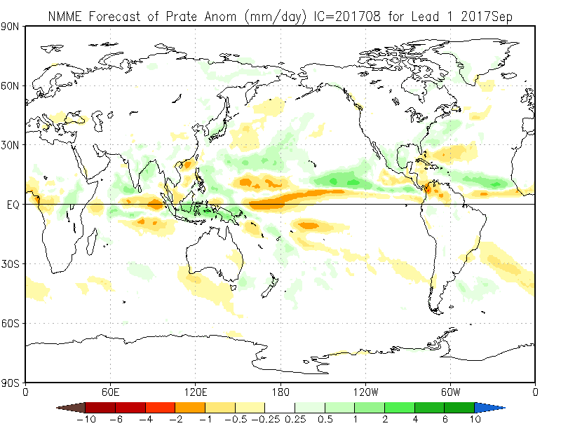
Here is the NMME for September in 2017. Shows dry SW Atlantic also so can’t really use this as general tracks. Guess Irma didn’t go through there lol. 
8 likes
Re: 2020 Indicators: SST's / SAL / MSLP / Steering / Shear / Instability / Sat Images
TheStormExpert wrote:toad strangler wrote:Steve wrote:
Those look great for SELA particularly if you don't want storms. I'm thinking something will get close to the mouth of the MS River during September and October to flip those anomalies though.
Yeah I don't look at these signals with steering in mind. I just see potential for storms. Where they go will be ironed out then. The dry anomaly off the E FL coast is much more pronounced than the SELA one though.
Of course shear and dry air are nonexistent now across Florida and The Bahamas, surprise, surprise!!(Still some mid-level dry air SE of Florida but a great improvement from last Friday when Isaias was approaching)
Hopefully it’ll return when it matters most but what a difference a week makes!
https://i.ibb.co/922CNwb/05-FDEA02-1116-46-BA-A84-A-9-B27-DB89426-B.gif
https://i.ibb.co/7jpSGp7/1-F1-BB521-A8-DB-4450-AF22-94846-E4-AE5-E5.jpg
https://i.ibb.co/SB8JRXD/477-DC43-A-AECD-48-CC-B4-D5-20-EA52041-A6-E.jpg
https://i.ibb.co/9phnVpb/38-D4-E8-B9-AF2-F-4-DB9-A8-E7-C11815-A7-C1-EC.gif
Bad signs for peak of season. It's low shear across most of the basin already this will continue to decrease
0 likes
-
TheStormExpert
Re: 2020 Indicators: SST's / SAL / MSLP / Steering / Shear / Instability / Sat Images
BYG Jacob wrote:shiny-pebble wrote:https://twitter.com/webberweather/status/1291810204020027394?s=19
Come and get your cruise tickets.
I don't think anyone is going to be crazy enough to get them regardless, it's 2020!
0 likes
-
TheStormExpert
Re: 2020 Indicators: SST's / SAL / MSLP / Steering / Shear / Instability / Sat Images
SFLcane wrote:Here is the NMME for September in 2017. Shows dry SW Atlantic also so can’t really use this as general tracks. Guess Irma didn’t go through there lol.
https://iili.io/dEB5pj.png
Still a good indicator that the ridging will likely be strong enough to steer storms towards land and not away.
1 likes
-
TheStormExpert
Re: 2020 Indicators: SST's / SAL / MSLP / Steering / Shear / Instability / Sat Images
I think a major a lot like Hurricane Allen (1980) or Hurricane Gilbert (1988) are increasingly likely. Typical Caribbean Cruiser paths.
https://en.wikipedia.org/wiki/Hurricane_Allen
https://en.wikipedia.org/wiki/Hurricane_Gilbert
https://en.wikipedia.org/wiki/Hurricane_Allen
https://en.wikipedia.org/wiki/Hurricane_Gilbert
0 likes
-
cycloneye

- Admin

- Posts: 149442
- Age: 69
- Joined: Thu Oct 10, 2002 10:54 am
- Location: San Juan, Puerto Rico
Re: 2020 Indicators: SST's / SAL / MSLP / Steering / Shear / Instability / Sat Images
TheStormExpert wrote:I think a major a lot like Hurricane Allen (1980) or Hurricane Gilbert (1988) are increasingly likely. Typical Caribbean Cruiser paths.
https://en.wikipedia.org/wiki/Hurricane_Allen
https://en.wikipedia.org/wiki/Hurricane_Gilbert
Also Ivan 2004.

1 likes
Visit the Caribbean-Central America Weather Thread where you can find at first post web cams,radars
and observations from Caribbean basin members Click Here
and observations from Caribbean basin members Click Here


Re: 2020 Indicators: SST's / SAL / MSLP / Steering / Shear / Instability / Sat Images
cycloneye wrote:TheStormExpert wrote:I think a major a lot like Hurricane Allen (1980) or Hurricane Gilbert (1988) are increasingly likely. Typical Caribbean Cruiser paths.
https://en.wikipedia.org/wiki/Hurricane_Allen
https://en.wikipedia.org/wiki/Hurricane_Gilbert
Also Ivan 2004.
https://upload.wikimedia.org/wikipedia/commons/thumb/3/32/Ivan_2004_track.png/1920px-Ivan_2004_track.png
Thats how Ivanhater got his screen name here.
3 likes
Who is online
Users browsing this forum: Google [Bot], tolakram and 191 guests