Nice detailed 5pm Disco!
Sure looks WNW not NW on the satellite, NHC has center in middle of Hispaniola... I guess that should work itself out in a few hours...
ATL: ISAIAS - Post-Tropical - Discussion
Moderator: S2k Moderators
-
Blown Away

- S2K Supporter

- Posts: 10253
- Joined: Wed May 26, 2004 6:17 am
Re: ATL: ISAIAS - Tropical Storm - Discussion
3 likes
Hurricane Eye Experience: David 79, Irene 99, Frances 04, Jeanne 04, Wilma 05… Hurricane Brush Experience: Andrew 92, Erin 95, Floyd 99, Matthew 16, Irma 17, Ian 22, Nicole 22…
-
Aric Dunn
- Category 5

- Posts: 21238
- Age: 43
- Joined: Sun Sep 19, 2004 9:58 pm
- Location: Ready for the Chase.
- Contact:
Re: ATL: ISAIAS - Tropical Storm - Discussion
Evil Jeremy wrote:The lack of a Hurricane Watch in the Central/Northern Bahamas is odd. I wouldn't be surprised if the Bahamas issues those within the next half hour.
its up to the goverments of each country if they want watches or warnings..
5 likes
Note: If I make a post that is brief. Please refer back to previous posts for the analysis or reasoning. I do not re-write/qoute what my initial post said each time.
If there is nothing before... then just ask
Space & Atmospheric Physicist, Embry-Riddle Aeronautical University,
I believe the sky is falling...
If there is nothing before... then just ask
Space & Atmospheric Physicist, Embry-Riddle Aeronautical University,
I believe the sky is falling...
-
Evil Jeremy

- S2K Supporter
- Posts: 5463
- Age: 32
- Joined: Mon Apr 10, 2006 2:10 pm
- Location: Los Angeles, CA
Re: ATL: ISAIAS - Tropical Storm - Discussion
jlauderdal wrote:Brown is the new Stewart, sounds like they want to intensify it more, lets see where that LLC finally forms than we can make a landfall prediction, maybe it neve hits land, runs the gulf stream off the coast and OTS before NC..regardless, we will have to prepare for a high end TS/CAT 1 and don't forget hanna was an over achiever so beware, it can happen...a few hours of motion not in the forecast and you get hit
I can't fathom Stewart would have maintained the same 75MPH intensity for 60 straight hours on the forecast.
8 likes
Frances 04 / Jeanne 04 / Katrina 05 / Wilma 05 / Fay 08 / Debby 12 / Andrea 13 / Colin 16 / Hermine 16 / Matthew 16 / Irma 17
-
jlauderdal
- S2K Supporter
- Posts: 7240
- Joined: Wed May 19, 2004 5:46 am
- Location: NE Fort Lauderdale
- Contact:
Re: ATL: ISAIAS - Tropical Storm - Discussion
good point, he would have went to 80 or 85 and then dialed it back...for now they keep it to our east, lets see how what happens with this LLC formationEvil Jeremy wrote:jlauderdal wrote:Brown is the new Stewart, sounds like they want to intensify it more, lets see where that LLC finally forms than we can make a landfall prediction, maybe it neve hits land, runs the gulf stream off the coast and OTS before NC..regardless, we will have to prepare for a high end TS/CAT 1 and don't forget hanna was an over achiever so beware, it can happen...a few hours of motion not in the forecast and you get hit
I can't fathom Stewart would have maintained the same 75MPH intensity for 60 straight hours on the forecast.
3 likes
-
Hurricane Mike
- Category 2

- Posts: 675
- Joined: Tue Apr 10, 2018 7:44 am
Re: ATL: ISAIAS - Tropical Storm - Discussion
Right now, Isaias has good low-level convergence and good upper-level divergence.
1 likes
-
jlauderdal
- S2K Supporter
- Posts: 7240
- Joined: Wed May 19, 2004 5:46 am
- Location: NE Fort Lauderdale
- Contact:
Re: ATL: ISAIAS - Tropical Storm - Discussion
they admitted the center was uncertain so lets see how the real weather turns out in a few hours with a "true" centerBlown Away wrote:Nice detailed 5pm Disco!
Sure looks WNW not NW on the satellite, NHC has center in middle of Hispaniola... I guess that should work itself out in a few hours...
5 likes

Re: ATL: ISAIAS - Tropical Storm - Discussion
Evil Jeremy wrote:jlauderdal wrote:Brown is the new Stewart, sounds like they want to intensify it more, lets see where that LLC finally forms than we can make a landfall prediction, maybe it neve hits land, runs the gulf stream off the coast and OTS before NC..regardless, we will have to prepare for a high end TS/CAT 1 and don't forget hanna was an over achiever so beware, it can happen...a few hours of motion not in the forecast and you get hit
I can't fathom Stewart would have maintained the same 75MPH intensity for 60 straight hours on the forecast.
They’re probably being very conservative with Isaias’ peak intensity until it has moved well enough away from Hispaniola and finally developed a concentrated core. It seems to be getting its act together quicker, which would favor more strengthening starting in 24 hours, but it could end up stalling intensity-wise due to dry air and/or shear interrupting its recovery.
3 likes
Irene '11 Sandy '12 Hermine '16 5/15/2018 Derecho Fay '20 Isaias '20 Elsa '21 Henri '21 Ida '21
I am only a meteorology enthusiast who knows a decent amount about tropical cyclones. Look to the professional mets, the NHC, or your local weather office for the best information.
I am only a meteorology enthusiast who knows a decent amount about tropical cyclones. Look to the professional mets, the NHC, or your local weather office for the best information.
-
toad strangler

- S2K Supporter
- Posts: 4546
- Joined: Sun Jul 28, 2013 3:09 pm
- Location: Earth
- Contact:
Re: ATL: ISAIAS - Tropical Storm - Discussion
Tropical Storm Watch by me on the Treasure Coast
1 likes
My Weather Station
https://www.wunderground.com/dashboard/pws/KFLPORTS603
https://www.wunderground.com/dashboard/pws/KFLPORTS603

Re: ATL: ISAIAS - Tropical Storm - Discussion
This is the best he has look and that is with him over the mountains of Hispaniola. What a strange year we are having. Who knows what he will do once he gets back over the water and flat islands of the Bahamas.
2 likes
Personal Forecast Disclaimer:
The posts in this forum are NOT official forecast and should not be used as such. They are just the opinion of the poster and may or may not be backed by sound meteorological data. They are NOT endorsed by any professional institution or storm2k.org. For official information, please refer to the NHC and NWS products.
The posts in this forum are NOT official forecast and should not be used as such. They are just the opinion of the poster and may or may not be backed by sound meteorological data. They are NOT endorsed by any professional institution or storm2k.org. For official information, please refer to the NHC and NWS products.
-
supercane4867
- Category 5
- Posts: 4966
- Joined: Wed Nov 14, 2012 10:43 am

-
Aric Dunn
- Category 5
- Posts: 21238
- Age: 43
- Joined: Sun Sep 19, 2004 9:58 pm
- Location: Ready for the Chase.
- Contact:
Re: ATL: ISAIAS - Tropical Storm - Discussion
not a huge change.
but if the center does reform under the MLC then 18z model initialization will be off since the position is in between. 00z models will end up being faster to the coast by a little if the move forward the center later.
"The
advisory position has been placed between the previous estimated
center location and the mid-level center until it becomes more clear
that reformation has occurred. "
0 likes
Note: If I make a post that is brief. Please refer back to previous posts for the analysis or reasoning. I do not re-write/qoute what my initial post said each time.
If there is nothing before... then just ask
Space & Atmospheric Physicist, Embry-Riddle Aeronautical University,
I believe the sky is falling...
If there is nothing before... then just ask
Space & Atmospheric Physicist, Embry-Riddle Aeronautical University,
I believe the sky is falling...

Re: ATL: ISAIAS - Tropical Storm - Discussion
Aric Dunn wrote:not a huge change.
but if the center does reform under the MLC then 18z model initialization will be off since the position is in between. 00z models will end up being faster to the coast by a little if the move forward the center later.
"The
advisory position has been placed between the previous estimated
center location and the mid-level center until it becomes more clear
that reformation has occurred. "
Once they are more confident in where the center is, what implications does this have to the models?
1 likes
-
otowntiger
- Category 5
- Posts: 1932
- Joined: Tue Aug 31, 2004 7:06 pm
Re: ATL: ISAIAS - Tropical Storm - Discussion
'Additional shifts' likely mean more shifts to the east, and they used to mention that there is a higher than usual uncertainty in TRACK and intensity. But they have dropped track in that statement. They apparently now have become pretty confident in track, or at least they have the normal amount of confidence in track. I feel pretty sure that the only adjustments in track from now on will be gradual but continual nudges to the east. Intensity is always a struggle for any storm but as they said even more so for this storm. But that looks like it will mainly be an issue for the Bahamas, in my opinion.Evil Jeremy wrote:A Tropical Storm Watch has been issued for the east coast of
Florida from Ocean Reef northward to Sebastian Inlet.
Discussion highlights:
"There is currently a significant
concentration of convection near the mid-level center that is
located along the northern coast of the island, and recent
surface observations suggest that a new center may be forming
near the area of mid-level rotation seen in satellite imagery. The
advisory position has been placed between the previous estimated
center location and the mid-level center until it becomes more clear
that reformation has occurred."
"The 1200 UTC dynamical model guidance has shifted eastward and now
that Isaias is expected to become a stronger and deeper cyclone,
that also favors a more eastward track. The updated official
forecast is a blend of the various consensus aids. Since the new
center is still in its formative stage some additional shifts in
the track may occur."
"It still needs to be stressed that that there is a higher
than usual amount of uncertainty in the intensity forecast."
No mention of possible future Hurricane Watches for Florida, although Storm Surge Watches are possible down the line.
75MPH Hurricane forecast from 36hrs-96hrs.
3 likes

Re: ATL: ISAIAS - Tropical Storm - Discussion
I'm curious how this band on the south side is going to handle going over the mountains as Isaias starts to move away from Hispaniola.

1 likes
Igor 2010, Sandy 2012, Fay 2014, Gonzalo 2014, Joaquin 2015, Nicole 2016, Humberto 2019, Imelda 2025
I am only a tropical weather enthusiast. My predictions are not official and may or may not be backed by sound meteorological data. For official information, please refer to the NHC and NWS products.
I am only a tropical weather enthusiast. My predictions are not official and may or may not be backed by sound meteorological data. For official information, please refer to the NHC and NWS products.
-
Aric Dunn
- Category 5
- Posts: 21238
- Age: 43
- Joined: Sun Sep 19, 2004 9:58 pm
- Location: Ready for the Chase.
- Contact:
Re: ATL: ISAIAS - Tropical Storm - Discussion
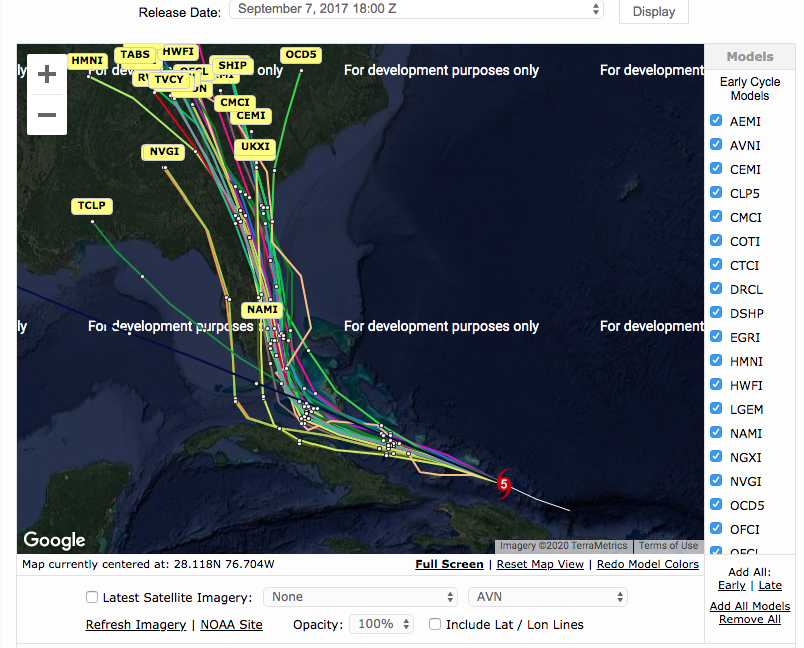
lets put it this way.......for everyone.. the source of this is from an Anonymous person I know lol.. FYI..
"Hi, I'm Irma! Here's my forecast track when I was north of the DR!"

"Hi, I'm Irma! Here's my forecast track when I was north of the DR!"
16 likes
Note: If I make a post that is brief. Please refer back to previous posts for the analysis or reasoning. I do not re-write/qoute what my initial post said each time.
If there is nothing before... then just ask
Space & Atmospheric Physicist, Embry-Riddle Aeronautical University,
I believe the sky is falling...
If there is nothing before... then just ask
Space & Atmospheric Physicist, Embry-Riddle Aeronautical University,
I believe the sky is falling...
-
DestinHurricane

- Category 4

- Posts: 935
- Joined: Tue May 01, 2018 8:05 am
- Location: New York, NY
Re: ATL: ISAIAS - Tropical Storm - Discussion
What is stopping it from hitting Florida if it moves faster than expected?
0 likes
Michael 2018

Re: ATL: ISAIAS - Tropical Storm - Discussion
Florida really lucks out because I’ve seen so many storms turn just 100 off the coast due to a break in the high pressure or a trough to save us and it’s happening again. We might actually have a nice breezy weekend and only a few showers but like another poster said the shifts would be east not west.
3 likes

Re: ATL: ISAIAS - Tropical Storm - Discussion
lhpfish wrote:Aric Dunn wrote:not a huge change.
but if the center does reform under the MLC then 18z model initialization will be off since the position is in between. 00z models will end up being faster to the coast by a little if the move forward the center later.
"The
advisory position has been placed between the previous estimated
center location and the mid-level center until it becomes more clear
that reformation has occurred. "
Once they are more confident in where the center is, what implications does this have to the models?
Won't probably make a big difference BUT if more accurately initialized later this evening and that initialization happens to be 20-40 miles further west due to its present fast forward speed..... then theoretically this would imply that the storm could well track about 30-40 miles further west prior to turning more Northwest in response to the trough. That could make a difference to that part of the Florida coastline where the storm approaches.
1 likes
Andy D
(For official information, please refer to the NHC and NWS products.)
(For official information, please refer to the NHC and NWS products.)
Re: ATL: ISAIAS - Tropical Storm - Discussion
Is he pumping the ridge to the N according to CIMISS from the three hours prior looks quite a bit stronger?opinions?
http://tropic.ssec.wisc.edu/real-time/d ... oom=&time=
http://tropic.ssec.wisc.edu/real-time/d ... oom=&time=
1 likes
-
supercane4867
- Category 5
- Posts: 4966
- Joined: Wed Nov 14, 2012 10:43 am
Re: ATL: ISAIAS - Tropical Storm - Discussion
Aric Dunn wrote:lets put it this way.......for everyone.. the source of this is from an Anonymous person I know lol.. FYI..
"Hi, I'm Irma! Here's my forecast track when I was north of Haiti!"
https://i.ibb.co/mcqhrNv/116681882-800965283972862-7590666102826528848-n.jpg
Interestingly, NAVGEM was the closest model to getting the track right at the time.
7 likes
Who is online
Users browsing this forum: No registered users and 31 guests