Hurricane NOEL : Discussions & Images
Moderator: S2k Moderators
-
Category 5

- Category 5

- Posts: 10074
- Age: 36
- Joined: Sun Feb 11, 2007 10:00 pm
- Location: New Brunswick, NJ
- Contact:
-
MusicCityMan

- Category 1

- Posts: 483
- Joined: Sat Feb 17, 2007 10:57 pm
- Location: Somewhere in Central Florida
-
caneman
Re: Tropical Storm NOEL : Discussions & Images
System has slowed to just 4 mph which is usually indicative of a steering change or change in direction.
0 likes
-
HURAKAN

- Professional-Met

- Posts: 46084
- Age: 39
- Joined: Thu May 20, 2004 4:34 pm
- Location: Key West, FL
- Contact:
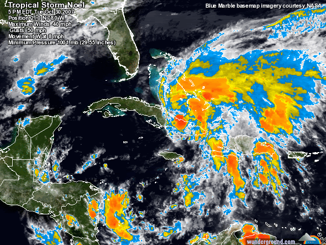
TWD 805:
...SPECIAL FEATURE...
NOEL IS DUMPING HEAVY RAINS OVER CUBA AND HISPANIOLA. AT 01/0000
UTC...THE CENTER OF TROPICAL STORM NOEL WAS LOCATED INLAND NEAR
LATITUDE 21.1 NORTH...LONGITUDE 78.1 WEST OR ABOUT 20 NM...40
KM...SOUTH-SOUTHWEST OF CAMAGUEY CUBA AND ABOUT 240 NM...440
KM...SOUTH OF NASSAU IN THE BAHAMAS. NOEL HAS BEEN DRIFTING
SLOWLY TOWARD THE WEST-NORTHWEST. A GRADUAL TURN TOWARD THE
NORTHWEST IS FORECAST DURING THE NEXT 24 HOURS. ON THIS TRACK...
THE CENTER OF NOEL IS EXPECTED TO REMAIN OVER CUBA OVERNIGHT...
BUT EMERGE OFF THE NORTHERN COAST OF CUBA ON WEDNESDAY.
ESTIMATED MINIMUM CENTRAL PRESSURE IS 1001 MB. MAXIMUM SUSTAINED
WINDS ARE NOW NEAR 35 KT WITH GUSTS TO 45 KT. LITTLE CHANGE IN
STRENGTH IS FORECAST UNTIL THE SYSTEM EMERGES BACK OVER WATER
NORTH OF CUBA. SEE THE NHC FORECAST/ADVISORY UNDER AWIPS/WMO
HEADERS MIATCMAT1/WTNT21 KNHC AND/OR THE PUBLIC ADVISORY UNDER
MIATCPAT1/WTNT31 KNHC FOR MORE DETAILS. SATELLITE IMAGERY...
SURFACE OBSERVATIONS AND RADAR FROM CAMAGUEY CUBA INDICATE THAT
CENTER OF NOEL REMAINS INLAND OVER EASTERN CUBA. HOWEVER...
RAINBANDS CONTINUE TO EXTEND WELL AWAY FROM THE CENTER AND ARE
SPREADING INTO THE BAHAMAS. A CLUSTER OF STRONG CONVECTION HAS
DEVELOPED EAST OF NOEL OVER LAS TUNAS. THIS TROPICAL CYCLONE IS
EXPECTED TO PRODUCE SIGNIFICANT RAINFALL ACCUMULATIONS OVER
HISPANIOLA...SOUTHEASTERN CUBA... AND THE BAHAMAS. THESE RAINS
ARE EXPECTED TO CAUSE LIFE-THREATENING FLASH FLOODS AND MUD
SLIDES. IN ADDITION TO THE RAINFALL THREAT...THE INTERACTION
BETWEEN NOEL...STRONG HIGH PRESSURE OVER THE MID ATLC STATES...
AND A STATIONARY FRONT EXTENDING ENE FROM CENTRAL FLORIDA IS
PRODUCING STRONG GUSTY ENE WINDS OVER PORTIONS OF FLORIDA AND
THE ADJACENT WATERS. DOPPLER RADAR IS SHOWING QUICK PASSING
SHOWERS OVER SOUTH FLORIDA AND THE FLORIDA KEYS.
0 likes

-
destruction92
- Category 1
- Posts: 312
- Joined: Sun Jul 22, 2007 10:43 pm
Re: Tropical Storm NOEL : Discussions & Images
Noel has slowed down from 8mph to 3mph and moving from W to now WNW....the 11 PM track may need to be shifted east....Floridians, be a little patient and maybe by 11 PM the NHC will signal the all clear for Florida...and following that, a better, more restful night of sleep.
0 likes
-
caneman
Re: Tropical Storm NOEL : Discussions & Images
destruction92 wrote:Noel has slowed down from 8mph to 3mph and moving from W to now WNW....the 11 PM track may need to be shifted east....Floridians, be a little patient and maybe by 11 PM the NHC will signal the all clear for Florida...and following that, a better, more restful night of sleep.
I think I just said that.
0 likes


-
MusicCityMan
- Category 1
- Posts: 483
- Joined: Sat Feb 17, 2007 10:57 pm
- Location: Somewhere in Central Florida
-
destruction92
- Category 1
- Posts: 312
- Joined: Sun Jul 22, 2007 10:43 pm
Re: Tropical Storm NOEL : Discussions & Images
caneman wrote:destruction92 wrote:Noel has slowed down from 8mph to 3mph and moving from W to now WNW....the 11 PM track may need to be shifted east....Floridians, be a little patient and maybe by 11 PM the NHC will signal the all clear for Florida...and following that, a better, more restful night of sleep.
I think I just said that.
Did you copyright what you said? geesh
Noel's slow movement is signaling the all clear for the U.S. TS watches are out of the question...SE Florida will not have much to deal with the way it is looking now...let's see if this slowing trend and northerly movement continues.
0 likes
-
caneman
Re:
Vortex wrote:Upon further review I was wrong in my assessment of a turn to the NNW. IR2 confirms moving just N or due west...
8:00 Advisory says WNW so seems reasonable and with the slow down I would expect it'll be moving NW if not N by 5:00 AM. Models tightly clustered, it's hard to imagine any thing different happening.
0 likes
-
destruction92
- Category 1
- Posts: 312
- Joined: Sun Jul 22, 2007 10:43 pm
Re:
Vortex wrote:Upon further review I was wrong in my assessment of a turn to the NNW. IR2 confirms moving just N or due west...
Isn't that wrong...according to the NHC 8PM advisory, Noel is moving west NORTHWEST.
If you can provide the coordinates you plotted to back up that assessment of "just N of due west".
0 likes

Re: Re:
destruction92 wrote:Vortex wrote:Upon further review I was wrong in my assessment of a turn to the NNW. IR2 confirms moving just N or due west...
Isn't that wrong...according to the NHC 8PM advisory, Noel is moving west NORTHWEST.
Um...NOEL HAS BEEN DRIFTING TOWARD THE WEST-NORTHWEST NEAR 4 MPH...6
KM/HR.
0 likes
-
caneman
Re: Tropical Storm NOEL Models Thread
HWRF 18Z has a broad 40-45 TS just off the coast of FLorida, if not a partial landfall. 18z GFDL is a little further EASt/ Here is the HWRF
http://moe.met.fsu.edu/cgi-bin/hwrftc2. ... =Animation
http://moe.met.fsu.edu/cgi-bin/hwrftc2. ... =Animation
0 likes


Re: Tropical Storm NOEL : Discussions & Images
Shortwave IR indicates a steady W or W-NW movement albeit slower than earlier today - by no means does it look like any imminent turn toward the NW. In fact, I think it will be offshore off the southern coast of Cuba by midnight still moving W or W-NW. What is truly amazing tonight, after being away a few hours, is that convection is increasing and near the LLC now while its over land whereas earlier it was displaced to the east near the MLC. I think now there is a good chance that Noel will strengthen as it emerges into the NW caribbean as it could be over open water (south of Cuba) for at least 12 hours. I see this storm maybe not being off the north coast of Cuba for another 24 hrs.
http://www.ssd.noaa.gov/goes/flt/t1/loop-ir2.html
http://www.ssd.noaa.gov/goes/flt/t1/loop-ir2.html
0 likes


-
cycloneye

- Admin

- Posts: 149569
- Age: 69
- Joined: Thu Oct 10, 2002 10:54 am
- Location: San Juan, Puerto Rico
Re: Tropical Storm NOEL Models Thread
WHXX01 KWBC 310041
CHGHUR
TROPICAL CYCLONE GUIDANCE MESSAGE
NWS TPC/NATIONAL HURRICANE CENTER MIAMI FL
0041 UTC WED OCT 31 2007
DISCLAIMER...NUMERICAL MODELS ARE SUBJECT TO LARGE ERRORS.
PLEASE REFER TO NHC OFFICIAL FORECASTS FOR TROPICAL CYCLONE
AND SUBTROPICAL CYCLONE INFORMATION.
ATLANTIC OBJECTIVE AIDS FOR
TROPICAL CYCLONE NOEL (AL162007) 20071031 0000 UTC
...00 HRS... ...12 HRS... ...24 HRS. .. ...36 HRS...
071031 0000 071031 1200 071101 0000 071101 1200
LAT LON LAT LON LAT LON LAT LON
BAMS 21.2N 77.9W 21.9N 79.4W 22.4N 80.3W 22.4N 80.7W
BAMD 21.2N 77.9W 21.8N 79.0W 22.6N 79.5W 23.6N 79.4W
BAMM 21.2N 77.9W 21.7N 79.2W 22.2N 79.8W 22.5N 80.0W
LBAR 21.2N 77.9W 22.0N 78.7W 23.1N 79.4W 24.6N 79.1W
SHIP 35KTS 38KTS 43KTS 48KTS
DSHP 35KTS 31KTS 39KTS 44KTS
...48 HRS... ...72 HRS... ...96 HRS. .. ..120 HRS...
071102 0000 071103 0000 071104 0000 071105 0000
LAT LON LAT LON LAT LON LAT LON
BAMS 22.0N 80.7W 21.0N 81.6W 19.9N 84.0W 18.0N 87.4W
BAMD 25.1N 77.7W 30.7N 68.9W 38.8N 61.5W 47.6N 56.6W
BAMM 23.0N 79.1W 24.6N 75.9W 29.4N 65.5W 35.3N 53.3W
LBAR 26.5N 78.9W 30.5N 74.8W 38.1N 66.3W .0N .0W
SHIP 55KTS 62KTS 62KTS 56KTS
DSHP 50KTS 57KTS 57KTS 42KTS
...INITIAL CONDITIONS...
LATCUR = 21.2N LONCUR = 77.9W DIRCUR = 305DEG SPDCUR = 4KT
LATM12 = 21.0N LONM12 = 77.0W DIRM12 = 270DEG SPDM12 = 8KT
LATM24 = 20.9N LONM24 = 74.5W
WNDCUR = 35KT RMAXWD = 90NM WNDM12 = 40KT
CENPRS = 1002MB OUTPRS = 1008MB OUTRAD = 180NM SDEPTH = M
RD34NE = 150NM RD34SE = 0NM RD34SW = 0NM RD34NW = 0NM
Moving now 305 degrees WNW at 4 kts.
0 likes
-
cycloneye
- Admin
- Posts: 149569
- Age: 69
- Joined: Thu Oct 10, 2002 10:54 am
- Location: San Juan, Puerto Rico
Re: Tropical Storm NOEL : Discussions & Images
LATCUR = 21.2N LONCUR = 77.9W DIRCUR = 305DEG SPDCUR = 4KT
The above from the 00:00 UTC Bams model suite iniciation of the run in terms of movement and location.Is moving WNW at 305 degrees.
The above from the 00:00 UTC Bams model suite iniciation of the run in terms of movement and location.Is moving WNW at 305 degrees.
0 likes
Who is online
Users browsing this forum: No registered users and 44 guests