ATL: FLORENCE - Post-Tropical - Discussion

Moderator: S2k Moderators

Message
Author
JarrodB

Re: ATL: FLORENCE - Hurricane - Discussion

#2381 Postby JarrodB » Tue Sep 11, 2018 1:47 am

I cant sleep :( and I am supposed to catch a flight home tomorrow morning.

This storm is really making my heart sink with each update/model run.

A landfalling cat 4 is bad enough but the potential to stall is alarming. In my amateur opinion catastrophic inland flooding is become more and more likely.
0 likes   

User avatar
MississippiWx
S2K Supporter
S2K Supporter
Posts: 1699
Joined: Sat Aug 14, 2010 1:44 pm
Location: Hattiesburg, Mississippi

Re: ATL: FLORENCE - Hurricane - Discussion

#2382 Postby MississippiWx » Tue Sep 11, 2018 1:54 am

It is pretty interesting watching the old small eye rotate around inside a new larger eye that is forming.
0 likes   
This post is not an official forecast and should not be used as such. It is just the opinion of MississippiWx and may or may not be backed by sound meteorological data. It is not endorsed by any professional institution including storm2k.org. For Official Information please refer to the NHC and NWS products.

emeraldislenc
Category 2
Category 2
Posts: 559
Joined: Fri Aug 24, 2012 4:49 pm
Location: Emerald Isle NC

Re: ATL: FLORENCE - Hurricane - Discussion

#2383 Postby emeraldislenc » Tue Sep 11, 2018 1:57 am

The staging area off the island is 26 feet high
6 likes   

User avatar
chaser1
S2K Supporter
S2K Supporter
Posts: 5495
Age: 64
Joined: Sat Oct 15, 2005 5:59 pm
Location: Longwood, Fl

Re: ATL: FLORENCE - Hurricane - Discussion

#2384 Postby chaser1 » Tue Sep 11, 2018 2:02 am

beoumont wrote:
Hybridstorm_November2001 wrote:
emeraldislenc wrote:If it is a cat 4 or 5 we will leave. We will move the first responders off the island.


Smart idea, if you've never experienced at category four or five up close you can't even imagine what it can do. I can say without exaggeration It is an extremely frightening ordeal. One I prefer not to speak of often. Long-term members here are familiar with my story, that is about it.


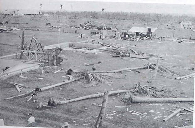
Below is image at Swan Island after cat 5 Hurricane Janet paid a visit in 1955 Anyone who thinks intercepting a cat 5 hurricane will be a fulfilling experience is just plain stupid.

http://www.hurricanevideo.citymax.com/i/swan_island.jpg


I'll Second that assessment!
0 likes   
Andy D

(For official information, please refer to the NHC and NWS products.)

User avatar
TheDreamTraveler
Category 2
Category 2
Posts: 641
Joined: Sun Aug 22, 2010 3:10 am
Location: PA

Re: ATL: FLORENCE - Hurricane - Discussion

#2385 Postby TheDreamTraveler » Tue Sep 11, 2018 2:02 am

JarrodB wrote:I cant sleep :( and I am supposed to catch a flight home tomorrow morning.

This storm is really making my heart sink with each update/model run.

A landfalling cat 4 is bad enough but the potential to stall is alarming. In my amateur opinion catastrophic inland flooding is become more and more likely.


Yeah...the inland flooding may be worse and more deadly than the actual landfall. We still don't know the exact points that will get flooded but there's a broad general idea where at. Depending on how the storm sets up and where/how it stalls it could drop up to 30 inches of rain or more. That's not an exaggeration :\

Some of these areas in North Carolina and ESPECIALLY Virginia have had their wettest summer on record. Which makes things a lot worse. Maryland and Pennsylvania really dodged a bullet here with the flooding rains. If those had setup even further north it would be an even bigger disaster.
1 likes   

User avatar
FLeastcoast
Tropical Depression
Tropical Depression
Posts: 84
Joined: Sun Sep 03, 2017 2:19 am
Location: NE Florida

Re: ATL: FLORENCE - Hurricane - Discussion

#2386 Postby FLeastcoast » Tue Sep 11, 2018 2:37 am

TheDreamTraveler wrote:
JarrodB wrote:I cant sleep :( and I am supposed to catch a flight home tomorrow morning.

This storm is really making my heart sink with each update/model run.

A landfalling cat 4 is bad enough but the potential to stall is alarming. In my amateur opinion catastrophic inland flooding is become more and more likely.


Yeah...the inland flooding may be worse and more deadly than the actual landfall. We still don't know the exact points that will get flooded but there's a broad general idea where at. Depending on how the storm sets up and where/how it stalls it could drop up to 30 inches of rain or more. That's not an exaggeration :\

Some of these areas in North Carolina and ESPECIALLY Virginia have had their wettest summer on record. Which makes things a lot worse. Maryland and Pennsylvania really dodged a bullet here with the flooding rains. If those had setup even further north it would be an even bigger disaster.


What is the approx amount of rainfall that is being predicted?
0 likes   

User avatar
FLeastcoast
Tropical Depression
Tropical Depression
Posts: 84
Joined: Sun Sep 03, 2017 2:19 am
Location: NE Florida

Re: ATL: FLORENCE - Hurricane - Discussion

#2387 Postby FLeastcoast » Tue Sep 11, 2018 2:38 am

FLeastcoast wrote:
TheDreamTraveler wrote:
JarrodB wrote:I cant sleep :( and I am supposed to catch a flight home tomorrow morning.

This storm is really making my heart sink with each update/model run.

A landfalling cat 4 is bad enough but the potential to stall is alarming. In my amateur opinion catastrophic inland flooding is become more and more likely.


Yeah...the inland flooding may be worse and more deadly than the actual landfall. We still don't know the exact points that will get flooded but there's a broad general idea where at. Depending on how the storm sets up and where/how it stalls it could drop up to 30 inches of rain or more. That's not an exaggeration :\

Some of these areas in North Carolina and ESPECIALLY Virginia have had their wettest summer on record. Which makes things a lot worse. Maryland and Pennsylvania really dodged a bullet here with the flooding rains. If those had setup even further north it would be an even bigger disaster.


What is the approx amount of rainfall that is being predicted?
never mind..I just saw it..my eyes are getting tired and blurry
0 likes   

xironman
S2K Supporter
S2K Supporter
Posts: 2522
Joined: Sun Jun 10, 2007 4:53 pm
Location: NoVA

Re: ATL: FLORENCE - Hurricane - Discussion

#2388 Postby xironman » Tue Sep 11, 2018 2:42 am

Aric Dunn wrote:
emeraldislenc wrote:Emerald Isle NC on the coast


I will come on wed and find a staging area nearby. However, the coast is the not a good idea. looking at your elevation of 10 feet. the estimated surge is 15 plus.. then wave action.. even if it weakens the surge will still be the same as a 4 or 5..


Wilmington, NC is the nearest place with parking garages I think,
0 likes   

Brent
S2K Supporter
S2K Supporter
Posts: 38104
Age: 37
Joined: Sun May 16, 2004 10:30 pm
Location: Tulsa Oklahoma
Contact:

Re: ATL: FLORENCE - Hurricane - Discussion

#2389 Postby Brent » Tue Sep 11, 2018 3:55 am

A STORM SURGE WATCH HAS BEEN ISSUED FOR THE EAST COAST OF THE
UNITED STATES FROM EDISTO BEACH...SOUTH CAROLINA NORTHWARD TO
THE NORTH CAROLINA-VIRGINIA BORDER...INCLUDING THE PAMLICO AND
ALBEMARLE SOUNDS.

A HURRICANE WATCH HAS BEEN ISSUED FOR THE EAST COAST OF THE UNITED
STATES FROM EDISTO BEACH... SOUTH CAROLINA... NORTHWARD TO THE
NORTH CAROLINA-VIRGINIA BORDER... INCLUDING THE PAMLICO AND
ALBEMARLE SOUNDS.
1 likes   
#neversummer

User avatar
1900hurricane
Category 5
Category 5
Posts: 6059
Age: 34
Joined: Fri Feb 06, 2015 12:04 pm
Location: Houston, TX
Contact:

Re: ATL: FLORENCE - Hurricane - Discussion

#2390 Postby 1900hurricane » Tue Sep 11, 2018 3:58 am

Eyewall replacement will be coming to a close soon.

Image
2 likes   
Contract Meteorologist. TAMU & MSST. Fiercely authentic, one of a kind. We are all given free will, so choose a life meant to be lived. We are the Masters of our own Stories.
Opinions expressed are mine alone.

Follow me on Twitter at @1900hurricane : Read blogs at https://1900hurricane.wordpress.com/

User avatar
Hammy
Category 5
Category 5
Posts: 5849
Age: 42
Joined: Fri May 25, 2012 5:25 pm
Contact:

Re: ATL: FLORENCE - Hurricane - Discussion

#2391 Postby Hammy » Tue Sep 11, 2018 3:59 am

Are they no longer issuing intermediate advisories when watches are posted?
0 likes   
The above post is not official and should not be used as such. It is the opinion of the poster and may or may not be backed by sound meteorological data. It is not endorsed by any professional institution or storm2k.org. For official information, please refer to the NHC and NWS products.

User avatar
TheDreamTraveler
Category 2
Category 2
Posts: 641
Joined: Sun Aug 22, 2010 3:10 am
Location: PA

Re: ATL: FLORENCE - Hurricane - Discussion

#2392 Postby TheDreamTraveler » Tue Sep 11, 2018 4:00 am

FLeastcoast wrote:
TheDreamTraveler wrote:
JarrodB wrote:I cant sleep :( and I am supposed to catch a flight home tomorrow morning.

This storm is really making my heart sink with each update/model run.

A landfalling cat 4 is bad enough but the potential to stall is alarming. In my amateur opinion catastrophic inland flooding is become more and more likely.


Yeah...the inland flooding may be worse and more deadly than the actual landfall. We still don't know the exact points that will get flooded but there's a broad general idea where at. Depending on how the storm sets up and where/how it stalls it could drop up to 30 inches of rain or more. That's not an exaggeration :\

Some of these areas in North Carolina and ESPECIALLY Virginia have had their wettest summer on record. Which makes things a lot worse. Maryland and Pennsylvania really dodged a bullet here with the flooding rains. If those had setup even further north it would be an even bigger disaster.


What is the approx amount of rainfall that is being predicted?


Not sure if you saw what the NHC said about it but here's what they said. We still don't know the exact locations but we do know which states will likely be effected.

RAINFALL: Florence is expected to produce total rainfall
accumulations of 15 to 20 inches with isolated maxima to 30 inches
near Florence's track over portions of North Carolina, Virginia, and
northern South Carolina through Saturday. This rainfall may produce
life-threatening flash flooding.
0 likes   

User avatar
TheDreamTraveler
Category 2
Category 2
Posts: 641
Joined: Sun Aug 22, 2010 3:10 am
Location: PA

Re: ATL: FLORENCE - Hurricane - Discussion

#2393 Postby TheDreamTraveler » Tue Sep 11, 2018 4:17 am

So about these rainfall totals...I didn't even realize some areas of North Carolina have had their wettest year on record too.. Wilmington has already had over 60 inches of rain this year which is their wettest year on record. This couldn't be any worse imo
1 likes   

User avatar
FLeastcoast
Tropical Depression
Tropical Depression
Posts: 84
Joined: Sun Sep 03, 2017 2:19 am
Location: NE Florida

Re: ATL: FLORENCE - Hurricane - Discussion

#2394 Postby FLeastcoast » Tue Sep 11, 2018 4:21 am

TheDreamTraveler wrote:So about these rainfall totals...I didn't even realize some areas of North Carolina have had their wettest year on record too.. Wilmington has already had over 60 inches of rain this year which is their wettest year on record. This couldn't be any worse imo


i agree. I have a relative in NC and I am so very glad that she decided to evacuate. I hope everyone in those areas took the warnings seriously.
1 likes   

emeraldislenc
Category 2
Category 2
Posts: 559
Joined: Fri Aug 24, 2012 4:49 pm
Location: Emerald Isle NC

Re: ATL: FLORENCE - Hurricane - Discussion

#2395 Postby emeraldislenc » Tue Sep 11, 2018 4:22 am

Looks liked they bumped the path a little to the left at the 5 am advisory
0 likes   

User avatar
GCANE
S2K Supporter
S2K Supporter
Posts: 11509
Joined: Mon Oct 22, 2007 8:03 am

Re: ATL: FLORENCE - Hurricane - Discussion

#2396 Postby GCANE » Tue Sep 11, 2018 4:29 am

Very unusual core rebuilding, very likely the end of the EWRC.
A tower fired off and sliced right through the eye.
Massive convective burst ensued after that on the SE quad.
Recon should be there shortly.

Image
0 likes   

User avatar
GCANE
S2K Supporter
S2K Supporter
Posts: 11509
Joined: Mon Oct 22, 2007 8:03 am

Re: ATL: FLORENCE - Hurricane - Discussion

#2397 Postby GCANE » Tue Sep 11, 2018 4:32 am

Obviously the end of the EWRC.
Pretty quick cycle time.
Recon will be able to measure the diameter of the new eye.

Image
2 likes   

User avatar
GCANE
S2K Supporter
S2K Supporter
Posts: 11509
Joined: Mon Oct 22, 2007 8:03 am

Re: ATL: FLORENCE - Hurricane - Discussion

#2398 Postby GCANE » Tue Sep 11, 2018 4:38 am

Dry slot still to the west, superimposed with a strong shear axis.
No sign of an outflow channel yet.
Would be a game changer if it could tap into 95L's convective debris.

Image
0 likes   

User avatar
GCANE
S2K Supporter
S2K Supporter
Posts: 11509
Joined: Mon Oct 22, 2007 8:03 am

Re: ATL: FLORENCE - Hurricane - Discussion

#2399 Postby GCANE » Tue Sep 11, 2018 4:47 am

Outflow Channel should start to kick in about this time tomorrow.

Image
0 likes   

User avatar
cycloneye
Admin
Admin
Posts: 145779
Age: 68
Joined: Thu Oct 10, 2002 10:54 am
Location: San Juan, Puerto Rico

Re: ATL: FLORENCE - Advisories

#2400 Postby cycloneye » Tue Sep 11, 2018 4:57 am

BULLETIN
Hurricane Florence Advisory Number 48...Corrected
NWS National Hurricane Center Miami FL AL062018
500 AM AST Tue Sep 11 2018

Corrected time of next advisory

...HURRICANE AND STORM SURGE WATCHES ISSUED FOR PORTIONS OF THE
COASTS OF NORTH AND SOUTH CAROLINA...


SUMMARY OF 500 AM AST...0900 UTC...INFORMATION
----------------------------------------------
LOCATION...26.4N 64.1W
ABOUT 410 MI...660 KM S OF BERMUDA
ABOUT 975 MI...1570 KM ESE OF CAPE FEAR NORTH CAROLINA
MAXIMUM SUSTAINED WINDS...140 MPH...220 KM/H
PRESENT MOVEMENT...WNW OR 290 DEGREES AT 15 MPH...24 KM/H
MINIMUM CENTRAL PRESSURE...944 MB...27.88 INCHES


Hurricane Florence Discussion Number 48
NWS National Hurricane Center Miami FL AL062018
500 AM AST Tue Sep 11 2018

Recent satellite imagery shows that the eye of Florence has become
cloud filled and an earlier 0441 UTC microwave overpass revealed a
double eyewall structure. These observations suggest that an
eyewall replacement cycle is likely underway. Subjective and
objective Dvorak current intensity numbers have not changed
so the initial intensity will remain 120 kt for this advisory.
An Air Force Reserve Hurricane Hunter mission is en route to the
storm and should provide a better assessment of Florence's
structure and intensity this morning. NOAA buoy 41049 located
about 80 nmi north of the eye, has reported tropical-storm-force
winds during the last several hours and seas as high as 23 ft.

Florence's upper-level environment is predicted to remain quite
favorable while the storm traverses sea surface temperatures of
around 29C over the next 48 hours. Additional strengthening is
forecast during this time, but some fluctuations in intensity are
likely due to eyewall replacement cycles. The updated NHC intensity
forecast once again calls for additional intensification and brings
Florence to near category 5 strength within the next 24 to 36
hours. After 48 hours, a slight increase in southwesterly
shear could result in some weakening, but Florence is expected to
remain an extremely dangerous hurricane when it approaches the U.S.
coastline.

Florence has accelerated as anticipated and is now moving
west-northwestward or 290 degrees at 13 kt. The track forecast
reasoning has not changed much. A mid-level ridge to the northeast
of Bermuda is expected steer Florence quickly west-northwestward to
northwestward toward the southeast United States coast over the next
2 to 3 days. By 72 hours, a high pressure ridge building over the
Upper-Midwest and Great Lakes regions is forecast to cause a
significant reduction in Florence's forward speed and the hurricane
is predicted to meander over the eastern portions of North or South
Carolina at days 4 and 5. The ECMWF has trended slower this cycle
at days 4 and 5, and as a result the NHC forecast shows slightly
less motion at those time periods. The spread in the guidance
increases by 72 hours, with the GFS and its ensemble mean along the
right side of the guidance, while the ECMWF remains along the left
edge. It should be noted that there are still a number of ECMWF
members that are even farther left. The NHC track forecast has been
nudged to the left and is close to the TVCN consensus aid. Given the
amount of uncertainty by day 3, it is important not to focus on the
exact forecast track as average NHC errors at days 3, 4, and 5 are
about 100, 140 and 180 n mi, respectively, and dangerous hazards
will extend well away from the center. Storm Surge and Hurricane
watches have been issued for a portion of the coast of South and
North Carolina. Additional watches may be required later today.


Key Messages:

1. A life-threatening storm surge is likely along portions of the
coastlines of South Carolina, North Carolina, and Virginia, and
a Storm Surge Watch has been issued for a portion of this area.
All interests from South Carolina into the mid-Atlantic region
should ensure they have their hurricane plan in place and follow
any advice given by local officials.

2. Life-threatening freshwater flooding is likely from a prolonged
and exceptionally heavy rainfall event, which may extend inland over
the Carolinas and Mid Atlantic for hundreds of miles as Florence is
expected to slow down as it approaches the coast and moves inland.

3. Damaging hurricane-force winds are likely along portions of the
coasts of South Carolina and North Carolina, and a Hurricane Watch
has been issued for a part of this area. Damaging winds could also
spread well inland into portions of the Carolinas and Virginia.

4. Large swells affecting Bermuda and portions of the U.S. East
Coast will continue this week, resulting in life-threatening surf
and rip currents.


FORECAST POSITIONS AND MAX WINDS

INIT 11/0900Z 26.4N 64.1W 120 KT 140 MPH
12H 11/1800Z 27.2N 66.4W 125 KT 145 MPH
24H 12/0600Z 28.7N 69.4W 130 KT 150 MPH
36H 12/1800Z 30.5N 72.2W 130 KT 150 MPH
48H 13/0600Z 32.2N 74.5W 125 KT 145 MPH
72H 14/0600Z 34.3N 77.1W 115 KT 130 MPH
96H 15/0600Z 35.2N 78.0W 45 KT 50 MPH...INLAND
120H 16/0600Z 36.0N 79.0W 25 KT 30 MPH...INLAND

$$
Forecaster Brown
0 likes   
Visit the Caribbean-Central America Weather Thread where you can find at first post web cams,radars
and observations from Caribbean basin members Click Here


Return to “2018”

Who is online

Users browsing this forum: No registered users and 1 guest