ATL: KIRK - Post-Tropical - Discussion

Moderator: S2k Moderators

Message
Author
User avatar
aspen
Category 5
Category 5
Posts: 8818
Joined: Sat Oct 12, 2019 7:10 pm
Location: Connecticut, USA

Re: ATL: KIRK - Hurricane - Discussion

#241 Postby aspen » Thu Oct 03, 2024 4:33 pm

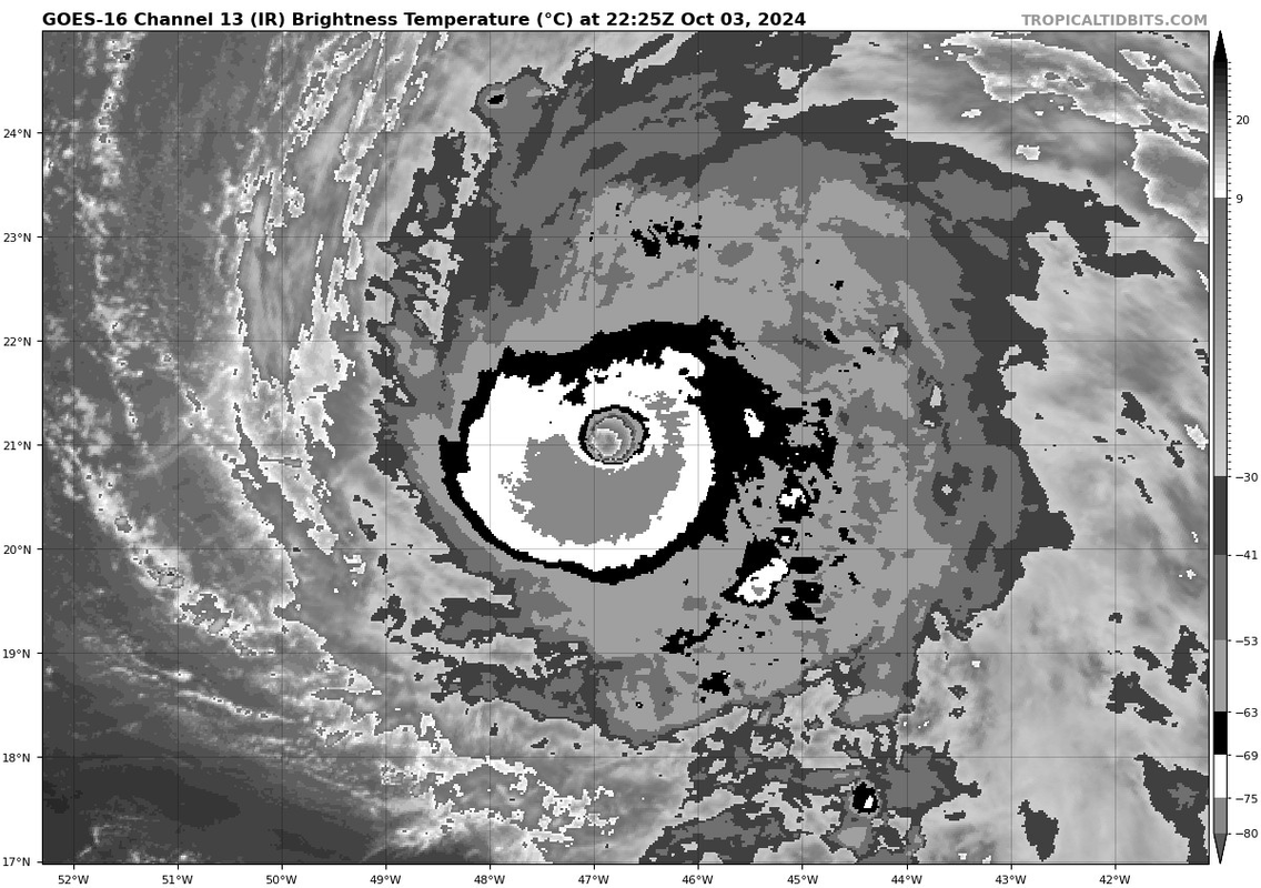
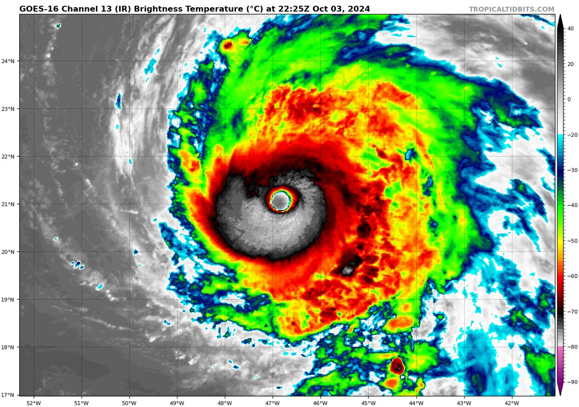
kevin wrote:It looks like Kirk might actually be trying to become a cat 5. Its satellite presentation is starting to approach perfection with a thick cold CDO which is somehow cooling rapidly over the last hour (average CDO temperature has decreased by 4 degrees in only 1 hour). Furthermore, the eye has continued to warm to +17.2C. CI# is still 'only' at 6.4 which translates to an intensity of 934mb/125kt. However, raw T# has shot up to 6.8, which would indicate a 135kt hurricane. If there isn't an EWRC I can realistically see Kirk reaching T# of 7.0 which would usually indicate a cat 5. Let's see what happens.

https://i.imgur.com/3PdeMh0.jpeg

https://i.imgur.com/6109I2q.png

I really hope the NHC puts out a special update sometime tonight, or else we’re gonna have an Atlantic Gilma lol.

It’s painfully obvious this is an upper-end 4, between the clear +17C eye, stadium effect, and thick complete W ring (even trying to go for a CMG ring as well).
7 likes   
Irene '11 Sandy '12 Hermine '16 5/15/2018 Derecho Fay '20 Isaias '20 Elsa '21 Henri '21 Ida '21

I am only a meteorology enthusiast who knows a decent amount about tropical cyclones. Look to the professional mets, the NHC, or your local weather office for the best information.

PDKlikatino
Tropical Low
Tropical Low
Posts: 20
Age: 19
Joined: Tue Aug 13, 2024 5:16 pm
Location: Tampa, FL

Re: ATL: KIRK - Hurricane - Discussion

#242 Postby PDKlikatino » Thu Oct 03, 2024 4:53 pm

Looks almost identical to Lee! :D

https://i.imgur.com/6109I2q.png
3 likes   
My posts are not official forecasts, just guesses. For accurate information, visit the NHC or NWS websites instead.

User avatar
WaveBreaking
Category 2
Category 2
Posts: 578
Joined: Sun Jun 30, 2024 11:33 am
Location: US

Re: ATL: KIRK - Hurricane - Discussion

#243 Postby WaveBreaking » Thu Oct 03, 2024 5:01 pm

It would be really nice to have recon for this storm

EDIT: Eye temp now 18.5°C


Image

Image
6 likes   
I am NOT a professional meteorologist, so take all of my posts with a grain of salt. My opinions are mine and mine alone.

User avatar
Travorum
Category 1
Category 1
Posts: 406
Joined: Tue Sep 05, 2023 9:36 am
Location: Dunedin, FL

Re: ATL: KIRK - Hurricane - Discussion

#244 Postby Travorum » Thu Oct 03, 2024 5:10 pm

WaveBreaking wrote:It would be really nice to have recon for this storm

EDIT: Eye temp now 18.5°C


https://i.imgur.com/B7WkAHF.jpeg

https://i.imgur.com/evZsEMO.jpeg


Yup. Lorenzo had research flights going into it, and while they weren't present at it's peak and aren't officially given as a reason for the C5 upgrade, the recon flights did provide data to confirm that earlier Dvorak classifications were correct. I imagine that provided TAFB and SAB a little more confidence in issuing the T7.0/7.0 Dvorak classification for Lorenzo that we're not going to get here, especially with how cagey NHC has gotten with ADT these days.
3 likes   

User avatar
aspen
Category 5
Category 5
Posts: 8818
Joined: Sat Oct 12, 2019 7:10 pm
Location: Connecticut, USA

Re: ATL: KIRK - Hurricane - Discussion

#245 Postby aspen » Thu Oct 03, 2024 5:11 pm

WaveBreaking wrote:It would be really nice to have recon for this storm

EDIT: Eye temp now 18.5°C


https://i.imgur.com/B7WkAHF.jpeg

https://i.imgur.com/evZsEMO.jpeg

Bruh. That’s 130-140 kt.

Cmon, put out a special update.
2 likes   
Irene '11 Sandy '12 Hermine '16 5/15/2018 Derecho Fay '20 Isaias '20 Elsa '21 Henri '21 Ida '21

I am only a meteorology enthusiast who knows a decent amount about tropical cyclones. Look to the professional mets, the NHC, or your local weather office for the best information.

User avatar
WaveBreaking
Category 2
Category 2
Posts: 578
Joined: Sun Jun 30, 2024 11:33 am
Location: US

Re: ATL: KIRK - Hurricane - Discussion

#246 Postby WaveBreaking » Thu Oct 03, 2024 5:12 pm

Did some digging and found a Dvorak IR image of Lorenzo (a vaguely similar case imo) right around the time it was upgraded to a 5. Even though Lorenzo has a more complete CMG ring, Kirk has a much warmer eye and will have more time to deepen. My guess is that Kirk peaks at 135kt/140kt.

Lorenzo
Image


Kirk
Image
4 likes   

I am NOT a professional meteorologist, so take all of my posts with a grain of salt. My opinions are mine and mine alone.

User avatar
kevin
Category 5
Category 5
Posts: 2586
Age: 26
Joined: Wed Aug 28, 2019 4:35 am

Re: ATL: KIRK - Hurricane - Discussion

#247 Postby kevin » Thu Oct 03, 2024 5:15 pm

I'm afraid that we're gonna be stuck with another 135 kt storm that might've been 140 kt. Also I don't know why the automatic ADT, even the corrected version, puts the center of Kirk in the northern half of the CDO instead of the center. Even with this erroneous center placement it still has a raw T# of 6.5, but I hope NHC uses better center fixes for their ADT analyses.

Image
5 likes   

User avatar
Travorum
Category 1
Category 1
Posts: 406
Joined: Tue Sep 05, 2023 9:36 am
Location: Dunedin, FL

Re: ATL: KIRK - Hurricane - Discussion

#248 Postby Travorum » Thu Oct 03, 2024 5:16 pm

kevin wrote:I'm afraid that we're gonna be stuck with another 135 kt storm that might've been 140 kt. Also I don't know why the automatic ADT, even the corrected version, puts the center of Kirk in the northern half of the CDO instead of the center. Even with this erroneous center placement it still has a raw T# of 6.5, but I hope NHC uses better center fixes for their ADT analyses.

https://i.imgur.com/1jtoKZJ.gif


seriously, ADT pegged the eye temp at +11.4C when there are pixels at almost +19C.
1 likes   

User avatar
kevin
Category 5
Category 5
Posts: 2586
Age: 26
Joined: Wed Aug 28, 2019 4:35 am

Re: ATL: KIRK - Hurricane - Discussion

#249 Postby kevin » Thu Oct 03, 2024 5:17 pm

It would be kinda crazy is 2024 manages to pump out a cat 5 in July and October, but not in August and September. Whatever happens, it's a weird season for sure.
6 likes   

User avatar
WaveBreaking
Category 2
Category 2
Posts: 578
Joined: Sun Jun 30, 2024 11:33 am
Location: US

Re: ATL: KIRK - Hurricane - Discussion

#250 Postby WaveBreaking » Thu Oct 03, 2024 5:17 pm

kevin wrote:I'm afraid that we're gonna be stuck with another 135 kt storm that might've been 140 kt. Also I don't know why the automatic ADT, even the corrected version, puts the center of Kirk in the northern half of the CDO instead of the center. Even with this erroneous center placement it still has a raw T# of 6.5, but I hope NHC uses better center fixes for their ADT analyses.

https://i.imgur.com/1jtoKZJ.gif


On the bright side, Kirk has about 24 more hours until it’s supposed to peak, so maybe that’ll give it enough time to convince the NHC to pull the trigger.


Also that outer band that was trying to initiate an EWRC failed to wrap around in the latest microwave image, so nothing should get in Kirk’s way.
Last edited by WaveBreaking on Thu Oct 03, 2024 5:20 pm, edited 1 time in total.
4 likes   

I am NOT a professional meteorologist, so take all of my posts with a grain of salt. My opinions are mine and mine alone.

User avatar
aspen
Category 5
Category 5
Posts: 8818
Joined: Sat Oct 12, 2019 7:10 pm
Location: Connecticut, USA

Re: ATL: KIRK - Hurricane - Discussion

#251 Postby aspen » Thu Oct 03, 2024 5:20 pm

kevin wrote:I'm afraid that we're gonna be stuck with another 135 kt storm that might've been 140 kt. Also I don't know why the automatic ADT, even the corrected version, puts the center of Kirk in the northern half of the CDO instead of the center. Even with this erroneous center placement it still has a raw T# of 6.5, but I hope NHC uses better center fixes for their ADT analyses.

https://i.imgur.com/1jtoKZJ.gif

Welcome back Sam ‘21.

Seriously how did ADT get so bad in the last year? Even in storms with huge obvious eyes like this one, it has such difficulty nailing the center. And some of the objective fixes have been bad too; they were stuck at T5.5 for 18z and dragged the blend down.
10 likes   
Irene '11 Sandy '12 Hermine '16 5/15/2018 Derecho Fay '20 Isaias '20 Elsa '21 Henri '21 Ida '21

I am only a meteorology enthusiast who knows a decent amount about tropical cyclones. Look to the professional mets, the NHC, or your local weather office for the best information.

User avatar
Travorum
Category 1
Category 1
Posts: 406
Joined: Tue Sep 05, 2023 9:36 am
Location: Dunedin, FL

Re: ATL: KIRK - Hurricane - Discussion

#252 Postby Travorum » Thu Oct 03, 2024 5:42 pm

ADT has raw and adj T# at 7.1, and a 92 degree difference between the eye and coldest tops:
2024OCT03 221020 6.5 931.7 127.0 6.5 7.1 7.1 NO LIMIT OFF OFF OFF OFF 18.89 -73.09 EYE 23 IR 68.6 21.03 46.78 ARCHER GOES16 40.4

UW - CIMSS
ADVANCED DVORAK TECHNIQUE
ADT-Version 9.1
Tropical Cyclone Intensity Algorithm

----- Current Analysis -----
Date : 03 OCT 2024 Time : 221020 UTC
Lat : 21:01:48 N Lon : 46:46:47 W


CI# /Pressure/ Vmax
6.5 / 931.7mb/127.0kt


Final T# Adj T# Raw T#
6.5 7.1 7.1

Estimated radius of max. wind based on IR : 23 km

Center Temp : +18.9C Cloud Region Temp : -73.1C

Scene Type : EYE
Last edited by Travorum on Thu Oct 03, 2024 5:47 pm, edited 1 time in total.
5 likes   

User avatar
Teban54
Category 5
Category 5
Posts: 3204
Joined: Sat May 19, 2018 1:19 pm

Re: ATL: KIRK - Hurricane - Discussion

#253 Postby Teban54 » Thu Oct 03, 2024 5:42 pm

Seeing some signs of the W ring being eroded in recent frames, even though the eye is warmer and clearer than before.

Image
Image
1 likes   

User avatar
kevin
Category 5
Category 5
Posts: 2586
Age: 26
Joined: Wed Aug 28, 2019 4:35 am

Re: ATL: KIRK - Hurricane - Discussion

#254 Postby kevin » Thu Oct 03, 2024 5:55 pm

For reference here is the automatic Dvorak ADT estimate all cat 5 hurricanes in the last 10 years.

Beryl (2024) = CI 6.9 / raw T# 7.0 / ADT intensity 928mb, 137kt
Lee (2023) = CI 6.8 / raw T# 7.0 / ADT intensity 930mb, 135kt
Ian (2022) = CI 6.9 / raw T# 7.2 / ADT intensity 922mb, 137 kt
Lorenzo (2019) = CI 7.1 / raw T# 7.3 / ADT intensity 914mb, 143 kt
Dorian (2019) = CI 6.4 / raw T# 6.5 / ADT intensity 936mb, 125 kt
Michael (2018) = CI 7.2 / raw T# 7.4 / ADT intensity 909mb , 146 kt
Maria (2017) = CI 7.1 / raw T# 7.3 / ADT intensity 922mb, 143 kt
Irma (2017) = CI 7.3 / raw T# 7.4 / ADT intensity 915mb, 149 kt
Matthew (2016) = CI 7.0 / raw T# 7.4 / ADT intensity 924mb, 140 kt

And some hurricanes that peaked at 135 kt.

Sam (2021) = CI 6.6 / raw T# 6.7 / ADT intensity 939mb, 130 kt
Iota (2020) = CI 7.0 / raw T# 7.5 / ADT intensity 922mb, 140 kt
Jose (2017) = CI 6.3 / raw T# 6.4 / ADT intensity 942mb, 122 kt
Joaquin (2015) = CI 6.5 / raw T# 6.7 / ADT intensity 928mb, 127 kt

And Eta just because it's my profile picture :lol:
Eta (2020) = CI 7.3 / raw T# 8.4 / ADT intensity 917 mb, 149 kt
5 likes   

User avatar
kevin
Category 5
Category 5
Posts: 2586
Age: 26
Joined: Wed Aug 28, 2019 4:35 am

Re: ATL: KIRK - Hurricane - Discussion

#255 Postby kevin » Thu Oct 03, 2024 5:59 pm

Finally a decent center fix. Eye temperature up to +18.9C and the CDO has cooled another 2 degrees over the last hour to a very impressive average of -73 degrees Celsius. CI# 6.5, but now with a more reasonable raw T# of 7.1. If the 7.1 manages to also translate to CI we're talking about a 143 kt hurricane.
6 likes   

User avatar
WaveBreaking
Category 2
Category 2
Posts: 578
Joined: Sun Jun 30, 2024 11:33 am
Location: US

Re: ATL: KIRK - Hurricane - Discussion

#256 Postby WaveBreaking » Thu Oct 03, 2024 6:02 pm

That outer band is trying to choke off the eye again (image is ~4 hours old), but Kirk’s eye is now the warmest it’s ever been at 19.8°C.

Image

Image
Last edited by WaveBreaking on Thu Oct 03, 2024 6:04 pm, edited 1 time in total.
0 likes   

I am NOT a professional meteorologist, so take all of my posts with a grain of salt. My opinions are mine and mine alone.

User avatar
Hurricane2022
Category 5
Category 5
Posts: 1541
Joined: Tue Aug 23, 2022 11:38 pm
Location: Araçatuba, Brazil

Re: ATL: KIRK - Hurricane - Discussion

#257 Postby Hurricane2022 » Thu Oct 03, 2024 6:04 pm

ImageImage
7 likes   
Sorry for the bad English sometimes...!
For reliable and detailed information for any meteorological phenomenon, please consult the National Hurricane Center, Joint Typhoon Warning Center , or your local Meteo Center.

--------

Una cvm Christo, pro Christo, et in Christo. Sit nomen Domini benedictvm.

User avatar
Travorum
Category 1
Category 1
Posts: 406
Joined: Tue Sep 05, 2023 9:36 am
Location: Dunedin, FL

Re: ATL: KIRK - Hurricane - Discussion

#258 Postby Travorum » Thu Oct 03, 2024 6:09 pm

Second ADT fix ≥ 7.0 raw T#, dragging the CI# kicking and screaming up to 6.6. Very interested in seeing what the subjective estimates are at 00z.

UW - CIMSS
ADVANCED DVORAK TECHNIQUE
ADT-Version 9.1
Tropical Cyclone Intensity Algorithm

----- Current Analysis -----
Date : 03 OCT 2024 Time : 224020 UTC
Lat : 21:04:47 N Lon : 46:50:24 W


CI# /Pressure/ Vmax
6.6 / 929.2mb/129.6kt


Final T# Adj T# Raw T#
6.6 7.0 7.0

Estimated radius of max. wind based on IR : 23 km

Center Temp : +18.7C Cloud Region Temp : -72.7C
Image
3 likes   

zzzh
Category 3
Category 3
Posts: 834
Joined: Thu Sep 02, 2021 1:13 pm

Re: ATL: KIRK - Hurricane - Discussion

#259 Postby zzzh » Thu Oct 03, 2024 6:14 pm

Image
2 likes   

User avatar
aspen
Category 5
Category 5
Posts: 8818
Joined: Sat Oct 12, 2019 7:10 pm
Location: Connecticut, USA

Re: ATL: KIRK - Hurricane - Discussion

#260 Postby aspen » Thu Oct 03, 2024 6:16 pm


Yeah…if the NHC doesn’t do a special update, they will 100% miss peak intensity by 11pm.
7 likes   
Irene '11 Sandy '12 Hermine '16 5/15/2018 Derecho Fay '20 Isaias '20 Elsa '21 Henri '21 Ida '21

I am only a meteorology enthusiast who knows a decent amount about tropical cyclones. Look to the professional mets, the NHC, or your local weather office for the best information.


Return to “2024”

Who is online

Users browsing this forum: No registered users and 5 guests