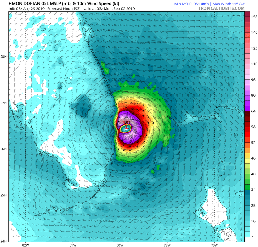
6z HMON making landfall in Palm Beach, quite a south shift from the 0z
https://www.tropicaltidbits.com/analysis/models/?model=hmon®ion=05L&pkg=ref&runtime=2019082906&fh=84
ATL: DORIAN - Models
Moderator: S2k Moderators
-
Bocadude85

- Category 5

- Posts: 2991
- Age: 39
- Joined: Mon Apr 18, 2005 2:20 pm
- Location: Honolulu,Hi
Re: ATL: DORIAN - Models
0 likes
-
Aric Dunn
- Category 5
- Posts: 21238
- Age: 43
- Joined: Sun Sep 19, 2004 9:58 pm
- Location: Ready for the Chase.
- Contact:
Re: ATL: DORIAN - Models
Bocadude85 wrote:6z HMON making landfall in Palm Beach, quite a south shift from the 0z
https://www.tropicaltidbits.com/analysis/models/?model=hmon®ion=05L&pkg=ref&runtime=2019082906&fh=84
With a wsw turn at the end. As it bombs out to a cat 4 borderline 5
0 likes
Note: If I make a post that is brief. Please refer back to previous posts for the analysis or reasoning. I do not re-write/qoute what my initial post said each time.
If there is nothing before... then just ask
Space & Atmospheric Physicist, Embry-Riddle Aeronautical University,
I believe the sky is falling...
If there is nothing before... then just ask
Space & Atmospheric Physicist, Embry-Riddle Aeronautical University,
I believe the sky is falling...

Re: ATL: DORIAN - Models
Bocadude85 wrote:6z HMON making landfall in Palm Beach, quite a south shift from the 0z
https://www.tropicaltidbits.com/analysis/models/?model=hmon®ion=05L&pkg=ref&runtime=2019082906&fh=84
Also shows the SW dip as well I think for the first time.
0 likes
The following post is NOT an official forecast and should not be used as such. It is just the opinion of the poster and may or may not be backed by sound meteorological data. It is NOT endorsed by any professional institution including storm2k.org For Official Information please refer to the NHC and NWS products.
-
Bocadude85
- Category 5
- Posts: 2991
- Age: 39
- Joined: Mon Apr 18, 2005 2:20 pm
- Location: Honolulu,Hi
Re: ATL: DORIAN - Models
Aric Dunn wrote:Bocadude85 wrote:6z HMON making landfall in Palm Beach, quite a south shift from the 0z
https://www.tropicaltidbits.com/analysis/models/?model=hmon®ion=05L&pkg=ref&runtime=2019082906&fh=84
With a wsw turn at the end. As it bombs out to a cat 4 borderline 5
Yup, we can add the HMON to the list of models showing a wsw track into Florida
0 likes

Re: ATL: DORIAN - Models
Aric Dunn wrote:Bocadude85 wrote:6z HMON making landfall in Palm Beach, quite a south shift from the 0z
https://www.tropicaltidbits.com/analysis/models/?model=hmon®ion=05L&pkg=ref&runtime=2019082906&fh=84
With a wsw turn at the end. As it bombs out to a cat 4 borderline 5
Yep it bends down WSW at the end as you say, not that dissimilar to the ICON either.
0 likes
Personal Forecast Disclaimer:
The posts in this forum are NOT official forecast and should not be used as such. They are just the opinion of the poster and may or may not be backed by sound meteorological data. They are NOT endorsed by any professional institution or storm2k.org. For official information, please refer to the NHC and NWS products
The posts in this forum are NOT official forecast and should not be used as such. They are just the opinion of the poster and may or may not be backed by sound meteorological data. They are NOT endorsed by any professional institution or storm2k.org. For official information, please refer to the NHC and NWS products
-
Emmett_Brown

- Category 5
- Posts: 1433
- Joined: Wed Aug 24, 2005 9:10 pm
- Location: Sarasota FL
Re: ATL: DORIAN - Models
More 0Z Euro ensemble members showing a recurve before hitting the SE coast than yesterday. All of them are slower members; the ridge has time to break down: https://www.weathernerds.org/tc_guidanc ... 0829074143
2 likes
-
jlauderdal
- S2K Supporter

- Posts: 7240
- Joined: Wed May 19, 2004 5:46 am
- Location: NE Fort Lauderdale
- Contact:
Re: ATL: DORIAN - Models
hmon says ya mon to sofla...something is up with these slow downs, the slower it is the more opportunity to stay off the coastBocadude85 wrote:Aric Dunn wrote:Bocadude85 wrote:6z HMON making landfall in Palm Beach, quite a south shift from the 0z
https://www.tropicaltidbits.com/analysis/models/?model=hmon®ion=05L&pkg=ref&runtime=2019082906&fh=84
With a wsw turn at the end. As it bombs out to a cat 4 borderline 5
Yup, we can add the HMON to the list of models showing a wsw track into Florida
1 likes
-
Blown Away

- S2K Supporter
- Posts: 10253
- Joined: Wed May 26, 2004 6:17 am
Re: ATL: DORIAN - Models

06z ICON... Bend to WSW at end of run... Hmmm
Last edited by Blown Away on Thu Aug 29, 2019 6:37 am, edited 1 time in total.
0 likes
Hurricane Eye Experience: David 79, Irene 99, Frances 04, Jeanne 04, Wilma 05… Hurricane Brush Experience: Andrew 92, Erin 95, Floyd 99, Matthew 16, Irma 17, Ian 22, Nicole 22…

Re: ATL: DORIAN - Models
northjaxpro wrote:USTropics wrote:It's a matter of timing between the ECMWF and GFS model on how quickly the ridge begins to retrograde back east and to what extent it extends westward. You can see this even 72 hours from now. The GFS moves it out earlier, which allows Dorian to round the periphery of the ridge a bit quicker than the ECMWF:
https://i.ibb.co/WGg5sBk/Webp-net-gifmaker-6.gif
Both models show a collapse in steering currents and a break in the ridge for this to turn north. There's a reason such a huge spread in the ECMWF ensembles exist from 12z to 00z, how quickly the ridge retreats and how far west Dorian gets will determine when Dorian moves north. You can see this in the ECMWF ensembles, here is an image of them just out to 120 hours:
https://i.ibb.co/hfrsFpn/ECMWF-120.jpg
Now add another 48 hours to those ensemble members, and the ones that have reached the GOM at 120 hours turn north towards panhandle, the ones off the Florida coast turn north to a recurve, and the one's over Florida move north up the spine:
https://i.ibb.co/cXnw0Wz/ECMWF-168.jpg
The UKMET ensembles show a very similar evolution:
https://i.imgur.com/VqAj4Ee.jpg
Great illustrations and analysis USTropics on the complex steering challenges in the forecast track of Dorian. This is going to drive me insane trying to see how it shakes down this weekend.
06z HWRF did make landfall north of 28 so that will help balance the HMON and Navgem solutions. I don't see any other new trends this morning that would call for any major modifications to the official forecast.
0 likes
-
toad strangler

- S2K Supporter
- Posts: 4546
- Joined: Sun Jul 28, 2013 3:09 pm
- Location: Earth
- Contact:
-
Emmett_Brown
- Category 5
- Posts: 1433
- Joined: Wed Aug 24, 2005 9:10 pm
- Location: Sarasota FL

Re: ATL: DORIAN - Models
Thank you all for the info! https://weather.us/model-charts/euro/20 ... 1800z.html
0 likes

Re: ATL: DORIAN - Models
Aric Dunn wrote:Given the setup i just dont see it getting that far north before turning westerly. I have a feeling we are going to see an even more gradual left turn before turning dew west. Which would bring it a little more south.
Yeah, Aric I was thinking the same thing. Starting with just a hint more of a forward track (5 degrees or so) more to the left currently, and then a further westward bend as Dorian becomes that much more trapped under the influence of the building ridge.... and feeling that much less influence from a departing Erin. This may suggest a bit of a quicker WNW forward speed to evolve in the nearer term. Then as models are suggesting this a.m., a slower approach as it nears the Florida coastline. I think NHC will shift the landfall a tad southward at 11:00. Perhaps Vero to Sebastian area.
1 likes
Andy D
(For official information, please refer to the NHC and NWS products.)
(For official information, please refer to the NHC and NWS products.)
-
DESTRUCTION5

- Category 5
- Posts: 4430
- Age: 44
- Joined: Wed Sep 03, 2003 11:25 am
- Location: Stuart, FL
Re: ATL: DORIAN - Models
Nimbus wrote:northjaxpro wrote:USTropics wrote:It's a matter of timing between the ECMWF and GFS model on how quickly the ridge begins to retrograde back east and to what extent it extends westward. You can see this even 72 hours from now. The GFS moves it out earlier, which allows Dorian to round the periphery of the ridge a bit quicker than the ECMWF:
https://i.ibb.co/WGg5sBk/Webp-net-gifmaker-6.gif
Both models show a collapse in steering currents and a break in the ridge for this to turn north. There's a reason such a huge spread in the ECMWF ensembles exist from 12z to 00z, how quickly the ridge retreats and how far west Dorian gets will determine when Dorian moves north. You can see this in the ECMWF ensembles, here is an image of them just out to 120 hours:
https://i.ibb.co/hfrsFpn/ECMWF-120.jpg
Now add another 48 hours to those ensemble members, and the ones that have reached the GOM at 120 hours turn north towards panhandle, the ones off the Florida coast turn north to a recurve, and the one's over Florida move north up the spine:
https://i.ibb.co/cXnw0Wz/ECMWF-168.jpg
The UKMET ensembles show a very similar evolution:
https://i.imgur.com/VqAj4Ee.jpg
Great illustrations and analysis USTropics on the complex steering challenges in the forecast track of Dorian. This is going to drive me insane trying to see how it shakes down this weekend.
06z HWRF did make landfall north of 28 so that will help balance the HMON and Navgem solutions. I don't see any other new trends this morning that would call for any major modifications to the official forecast.
If it makes it to the FL coast and don't pull a Floyd it's 1000 times more likely to pull a HMON into PBC vs HWRF based on climo.
0 likes
GATOR NATION IS E V E R Y W H E R E !
-
gatorcane

- S2K Supporter
- Posts: 23708
- Age: 48
- Joined: Sun Mar 13, 2005 3:54 pm
- Location: Boca Raton, FL
Re: ATL: DORIAN - Models
06Z HMON with WSW dive into South Florida nearly over my house in Boca Raton. The WSW dip shown by several of the models is interesting and extremely concerning:
1 likes

Re: ATL: DORIAN - Models
Emmett_Brown wrote:Has anyone seen any 6Z Euro info?
It starts coming out in 20 minutes.
0 likes
-
SFLcane

- S2K Supporter
- Posts: 10281
- Age: 48
- Joined: Sat Jun 05, 2010 1:44 pm
- Location: Lake Worth Florida
Re: ATL: DORIAN - Models
That’s quite the shift with the HMON...as others have stated the wsw dip is interesting.
0 likes
Re: ATL: DORIAN - Models
Have to admit that the 0Z Euro ensemble tracks suggesting the possibility of a more northward recurve just prior to or near landfall, is an interesting fly in the ointment. Curious how much later in time those particular member have this occur given some other model support showing the contrary - a short term dip toward the WSW. Timing is everything..... timing is everything.... timing is everything
0 likes
Andy D
(For official information, please refer to the NHC and NWS products.)
(For official information, please refer to the NHC and NWS products.)

Re: ATL: DORIAN - Models
Emmett_Brown wrote:More 0Z Euro ensemble members showing a recurve before hitting the SE coast than yesterday. All of them are slower members; the ridge has time to break down: https://www.weathernerds.org/tc_guidanc ... 0829074143
Lets hope this slowdown and recurve shown by some ensemble members becomes a trend the other models start picking up on.
1 likes
-
toad strangler
- S2K Supporter
- Posts: 4546
- Joined: Sun Jul 28, 2013 3:09 pm
- Location: Earth
- Contact:
Re: ATL: DORIAN - Models
chaser1 wrote:Have to admit that the 0Z Euro ensemble tracks suggesting the possibility of a more northward recurve just prior to or near landfall, is an interesting fly in the ointment. Curious how much later in time those particular member have this occur given some other model support showing the contrary - a short term dip toward the WSW. Timing is everything..... timing is everything.... timing is everything
Well looking back to last nights 18z Euro ensembles and then the 0z suite it's quite possible 12z boots Dorian N and possible recurve before landfall. Trend?
Last edited by toad strangler on Thu Aug 29, 2019 6:53 am, edited 1 time in total.
0 likes
My Weather Station
https://www.wunderground.com/dashboard/pws/KFLPORTS603
https://www.wunderground.com/dashboard/pws/KFLPORTS603
Who is online
Users browsing this forum: No registered users and 35 guests