ATL: FLORENCE - Post-Tropical - Discussion

Moderator: S2k Moderators

Message
Author
User avatar
ConvergenceZone
Category 5
Category 5
Posts: 5194
Joined: Fri Jul 29, 2005 1:40 am
Location: Northern California

Re: ATL: FLORENCE - Hurricane - Discussion

#2501 Postby ConvergenceZone » Tue Sep 11, 2018 11:00 am

sittingduck wrote:I found this part of the 11 am discussion interesting but confusing - especially the last line. I understand what they are saying about weakening, but are they saying that they don't believe that she will be as strong as the official intensity forecast?

here is the part By 48 h and
beyond, Florence's slow forward speed, coupled with the large eye
and relatively shallow depth of the warm water should induce some
upwelling beneath the cyclone that will initiate a slow weakening
trend. By 72 hours the vertical wind shear is expected to increase
to near 20 kt from the southwest, which will cause more significant
weakening to occur. However, given the large overall wind field of
Florence along with the large eye, only gradual weakening is
expected. Once Florence moves inland, the slow forward speed of 3-5
kt will result in rapid spin down and weakening of the wind field.
The new official intensity forecast is above of all of the intensity
guidance based on this e aforementioned very favorable synoptic outflow
pattern, and to maintain continuity with the previous forecast.


I think a cat 3 is most likely at landfall. In spite of the weakening forecast, I don’t think it will landfall as a cat 2, but that’s still possible
1 likes   

Vdogg
Category 2
Category 2
Posts: 621
Joined: Wed Aug 31, 2016 9:56 am

Re: ATL: FLORENCE - Hurricane - Discussion

#2502 Postby Vdogg » Tue Sep 11, 2018 11:00 am

So CMC goes way north to OBX and GFS goes way south to the NC/SC border. The actual hurricane has been slightly north of the predicted Euro track. I give up. At this point I’m just going to wait for the storm to roll in.
0 likes   

User avatar
wxman57
Moderator-Pro Met
Moderator-Pro Met
Posts: 22989
Age: 67
Joined: Sat Jun 21, 2003 8:06 pm
Location: Houston, TX (southwest)

Re: ATL: FLORENCE - Hurricane - Discussion

#2503 Postby wxman57 » Tue Sep 11, 2018 11:02 am

Dean4Storms wrote:Note that the Cone has shifted back south again to the GA/SC border. Still some uncertainty IMO on where exactly the track lies, the stall and if there is a true WSW motion as the ECM and GFS indicate. If that happens just offshore upper SC Coast and then moves WSW then the ramifications are going to change wholeheartedly!


That is because the 66.7% past 5 year error circle at their final position (well inland) is quite large. Look at the narrow part of the cone that takes it to landfall. It extends from the upper SC coast north to Cape Hatteras. That's the area at most risk for a landfall.
1 likes   

craptacular
Category 2
Category 2
Posts: 581
Joined: Wed Aug 02, 2006 9:17 pm
Location: The Mad City, WI

Re: ATL: FLORENCE - Hurricane - Discussion

#2504 Postby craptacular » Tue Sep 11, 2018 11:05 am

sittingduck wrote:I found this part of the 11 am discussion interesting but confusing - especially the last line. I understand what they are saying about weakening, but are they saying that they don't believe that she will be as strong as the official intensity forecast?
...
The new official intensity forecast is above of all of the intensity
guidance based on the aforementioned very favorable synoptic outflow
pattern, and to maintain continuity with the previous forecast.


Focus on second part of that sentence. The NHC doesn't like to make big changes to forecast tracks and/or forecast intensity at each update. So, even if most/all of the models have big changes from run to run, the official forecast doesn't necessarily follow suit. They prefer to nudge the forecast based on trends rather than jump all over the place. You can see how people in here react to big changes in the models ... now imagine how the 99.99%+ of the general public that doesn't follow as closely would react if the forecast track cone and intensity bounced around every 6 hours.
2 likes   

supercane4867
Category 5
Category 5
Posts: 4966
Joined: Wed Nov 14, 2012 10:43 am

Re: ATL: FLORENCE - Hurricane - Discussion

#2505 Postby supercane4867 » Tue Sep 11, 2018 11:12 am

Very solid eyewall on the new AMSU pass

Image
1 likes   

User avatar
Blinhart
Category 5
Category 5
Posts: 2081
Age: 48
Joined: Thu Sep 08, 2011 3:13 pm
Location: Crowley, La.

Re: ATL: FLORENCE - Hurricane - Discussion

#2506 Postby Blinhart » Tue Sep 11, 2018 11:14 am

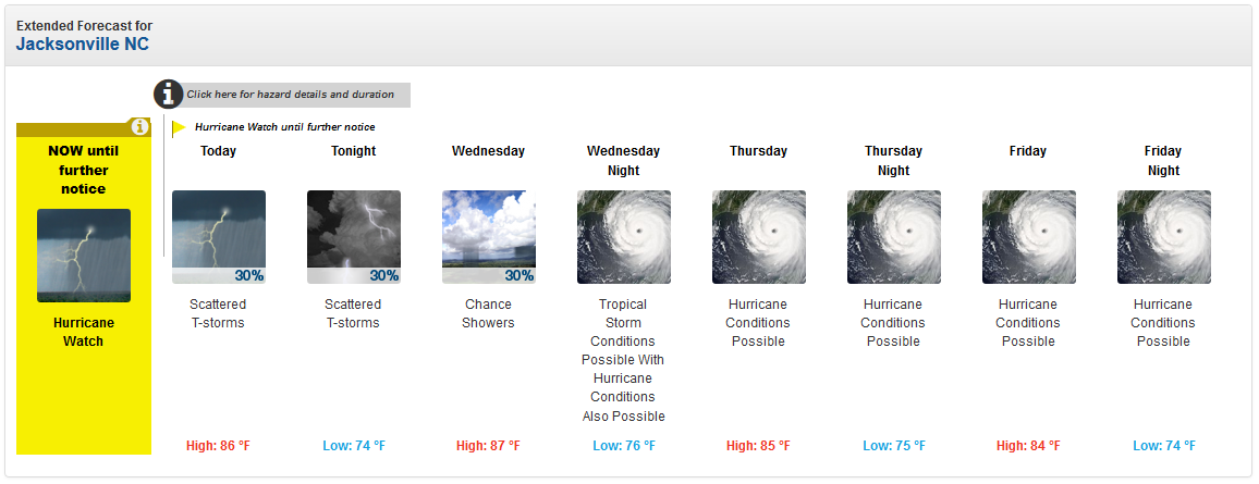
supercane4867 wrote::double:

Image


Never seen a forecast like that. And I live in South Louisiana, that says something. I have seen it when it has Tropical Storm Conditions for a few days but not Hurricane.
5 likes   
Personal Forecast Disclaimer:
The posts in this forum are NOT official forecast and should not be used as such. They are just the opinion of the poster and may or may not be backed by sound meteorological data. They are NOT endorsed by any professional institution or storm2k.org. For official information, please refer to the NHC and NWS products.

User avatar
PTPatrick
Category 5
Category 5
Posts: 1831
Joined: Sat Jun 12, 2004 8:38 am

Re: ATL: FLORENCE - Hurricane - Discussion

#2507 Postby PTPatrick » Tue Sep 11, 2018 11:22 am

The trend of slow down at the coast and potential shear will be helpful with the wind and inland power loss. Even if it maintains 4 strength right up the coast(which appears slightly in doubt) slow movement and upwelling seems like it cause some degradation near landfall, and probably keep any cat 4 wind just offshore minimize the wind that can translate to the surface well inland. The trade off is the surge and flooding will worse. This at least appears like it will end up closer to a Floyd on misery spectrum than a Hazel or Hugo. But every storm is different and the sheer length of time with it hovering near the coast, and size, this could make Floyd seem like an April shower.

Slow moving canes just bring their own kind of misery. I remember when Georges hit my home town and stalled and rained out and flooded with surge, it felt like we were in exile for close to 3 days just watching it rain. It sucked.
Last edited by PTPatrick on Tue Sep 11, 2018 11:25 am, edited 1 time in total.
0 likes   

User avatar
artist
Category 5
Category 5
Posts: 9792
Joined: Mon Jun 06, 2005 3:26 pm
Location: West Palm

Re: ATL: FLORENCE - Hurricane - Discussion

#2508 Postby artist » Tue Sep 11, 2018 11:24 am

Dean4Storms wrote:Note that the Cone has shifted back south again to the GA/SC border. Still some uncertainty IMO on where exactly the track lies, the stall and if there is a true WSW motion as the ECM and GFS indicate. If that happens just offshore upper SC Coast and then moves WSW then the ramifications are going to change wholeheartedly!


Yep, I sense a touch of uncertainty in the following-

GOES-16 high-resolution water vapor imagery indicates that the
amplifying large-scale flow pattern across CONUS is inducing a
downstream ridge over the western Atlantic, with a high pressure
cell centered northwest of Bermuda. This blocking ridge pattern is
expected to keep Florence moving west-northwestward to northwest at
around 15 kt for the next 48 hours or so. However, embedded within
the large-scale flow is a weak shortwave trough over the central and
southern Plains that is expected to eject out northeastward and
weaken the ridging across the mid-Atlantic and southeastern U.S.,
causing Florence to slow down significantly in 72 hours as the
powerful hurricane approaches the Carolinas. On days 4 and 5, an
even slower motion or drift to the west and northwest is forecast,
which will exacerbate the heavy rainfall threat
1 likes   

psyclone
S2K Supporter
S2K Supporter
Posts: 4769
Joined: Wed Aug 24, 2005 9:04 pm
Location: palm harbor fl

Re: ATL: FLORENCE - Hurricane - Discussion

#2509 Postby psyclone » Tue Sep 11, 2018 11:27 am

Blinhart wrote:
supercane4867 wrote::double:


Never seen a forecast like that. And I live in South Louisiana, that says something. I have seen it when it has Tropical Storm Conditions for a few days but not Hurricane.


Note that it says hurricane conditions "possible" not likey. This forecast is probably more reflective of a lack of granularity at this juncture rather than a protracted period of hurricane conditions. what will likely happen is hurricane/ts conditions will be updated to "likely" for a smaller block of time as the forecast timeframe reels in.
2 likes   

floridasun78
Category 5
Category 5
Posts: 3755
Joined: Sun May 17, 2009 10:16 pm
Location: miami fl

Re: ATL: FLORENCE - Hurricane - Discussion

#2510 Postby floridasun78 » Tue Sep 11, 2018 11:30 am

i hearing alot people will not leave their think their safe area
0 likes   

User avatar
Kazmit
Category 5
Category 5
Posts: 2125
Age: 22
Joined: Mon Jul 25, 2016 8:49 am
Location: Williamsburg, VA / Bermuda

Re: ATL: FLORENCE - Hurricane - Discussion

#2511 Postby Kazmit » Tue Sep 11, 2018 11:31 am

Right now it looks a lot like Isabel before it went annular.
3 likes   
Igor 2010, Sandy 2012, Fay 2014, Gonzalo 2014, Joaquin 2015, Nicole 2016, Humberto 2019

I am only a tropical weather enthusiast. My predictions are not official and may or may not be backed by sound meteorological data. For official information, please refer to the NHC and NWS products.

floridasun78
Category 5
Category 5
Posts: 3755
Joined: Sun May 17, 2009 10:16 pm
Location: miami fl

Re: ATL: FLORENCE - Hurricane - Discussion

#2512 Postby floridasun78 » Tue Sep 11, 2018 11:33 am

looking at north Carolina beach cam all left beach only police are on sand
1 likes   

tolakram
Admin
Admin
Posts: 20017
Age: 62
Joined: Sun Aug 27, 2006 8:23 pm
Location: Florence, KY (name is Mark)

Re: ATL: FLORENCE - Hurricane - Discussion

#2513 Postby tolakram » Tue Sep 11, 2018 11:43 am

Huge 40MB loop as the eye clears back out.

9 likes   
M a r k
- - - - -
Join us in chat: Storm2K Chatroom Invite. Android and IOS apps also available.

The posts in this forum are NOT official forecasts and should not be used as such. Posts are NOT endorsed by any professional institution or STORM2K.org. For official information and forecasts, please refer to NHC and NWS products.

User avatar
Blinhart
Category 5
Category 5
Posts: 2081
Age: 48
Joined: Thu Sep 08, 2011 3:13 pm
Location: Crowley, La.

Re: ATL: FLORENCE - Hurricane - Discussion

#2514 Postby Blinhart » Tue Sep 11, 2018 11:45 am

tolakram wrote:Huge 40MB loop as the eye clears back out.

[im gur]https://imgur.com/ixEx2wp[/imgur]


Can see the huge mesoscales inside that huge eye.
1 likes   
Personal Forecast Disclaimer:
The posts in this forum are NOT official forecast and should not be used as such. They are just the opinion of the poster and may or may not be backed by sound meteorological data. They are NOT endorsed by any professional institution or storm2k.org. For official information, please refer to the NHC and NWS products.

Aric Dunn
Category 5
Category 5
Posts: 21238
Age: 42
Joined: Sun Sep 19, 2004 9:58 pm
Location: Ready for the Chase.
Contact:

Re: ATL: FLORENCE - Hurricane - Discussion

#2515 Postby Aric Dunn » Tue Sep 11, 2018 11:50 am

Kazmit wrote:Right now it looks a lot like Isabel before it went annular.


with these large eyes... starting to see those pentagram shapes spinning around...
1 likes   
Note: If I make a post that is brief. Please refer back to previous posts for the analysis or reasoning. I do not re-write/qoute what my initial post said each time.
If there is nothing before... then just ask :)

Space & Atmospheric Physicist, Embry-Riddle Aeronautical University,
I believe the sky is falling...

User avatar
GCANE
S2K Supporter
S2K Supporter
Posts: 11509
Joined: Mon Oct 22, 2007 8:03 am

Re: ATL: FLORENCE - Hurricane - Discussion

#2516 Postby GCANE » Tue Sep 11, 2018 11:59 am

3 likes   

User avatar
GCANE
S2K Supporter
S2K Supporter
Posts: 11509
Joined: Mon Oct 22, 2007 8:03 am

Re: ATL: FLORENCE - Hurricane - Discussion

#2517 Postby GCANE » Tue Sep 11, 2018 12:00 pm

[youtube]https://youtu.be/-ah9POMe3rM[/youtube]
0 likes   

User avatar
GCANE
S2K Supporter
S2K Supporter
Posts: 11509
Joined: Mon Oct 22, 2007 8:03 am

Re: ATL: FLORENCE - Hurricane - Discussion

#2518 Postby GCANE » Tue Sep 11, 2018 12:01 pm

NOAA pilot Justin Kibbey discusses his flights through Hurricane Florence, which was upgraded today to a Category 4 storm.


[youtube]https://youtu.be/6gFWwtZX6Sg[/youtube]
1 likes   

Vdogg
Category 2
Category 2
Posts: 621
Joined: Wed Aug 31, 2016 9:56 am

Re: ATL: FLORENCE - Hurricane - Discussion

#2519 Postby Vdogg » Tue Sep 11, 2018 12:08 pm

There is currently a stationary front draped across the southeast. How will Florence interact with that? Will it enhance the rainfall?
0 likes   

txag2005
Tropical Storm
Tropical Storm
Posts: 229
Joined: Thu Jul 17, 2008 1:16 am
Location: Houston, TX

Re: ATL: FLORENCE - Hurricane - Discussion

#2520 Postby txag2005 » Tue Sep 11, 2018 12:18 pm

I really hope people are taking the forecast of upwards of 30 inches of rain in areas serious, especially in inland areas that won’t really get the top winds or storm surge.

Having experienced Harvey, I know tons of people who lived outside of flood planes who felt safe that had flooding in their homes. I know several families that went to bed with everything seeming ok and they woke up in the middle of the night with water in their home quickly rising and needing immediate rescues.

I hope everybody heeds the warnings and forecasts and is well prepared. Please stay safe if you are in an affected area. My heart and prayers are with you all.
1 likes   


Return to “2018”

Who is online

Users browsing this forum: No registered users and 3 guests