Moderator: S2k Moderators


Shell Mound wrote:So far models seem to be underestimating the tenacity of the TUTT and are now showing strong VWS through the end of August.
captainbarbossa19 wrote:Shell Mound wrote:So far models seem to be underestimating the tenacity of the TUTT and are now showing strong VWS through the end of August.
One big change that is about to happen is that the EPAC is about to shut down. I am doubtful that the Atlantic will remain unfavorable after this happens for long.

Shell Mound wrote:captainbarbossa19 wrote:Shell Mound wrote:So far models seem to be underestimating the tenacity of the TUTT and are now showing strong VWS through the end of August.
One big change that is about to happen is that the EPAC is about to shut down. I am doubtful that the Atlantic will remain unfavorable after this happens for long.
The EPS in late July suggested that the TUTT would have become far weaker by this date than it actually is. The GEFS shows the TUTT persisting through 30 August.
aspen wrote:I’m starting to wonder if we’ll have to wait until September for the first sub-990 mbar storm of the season, if the African monsoon remains too strong for development east of 50W and the ridging is positioned in just the right way to put everything on a track into the islands.
Imagine if that little low pressure system near Bermuda with barely any model support ends up as a stronger system than either Fred or Grace lol
MarioProtVI wrote:aspen wrote:I’m starting to wonder if we’ll have to wait until September for the first sub-990 mbar storm of the season, if the African monsoon remains too strong for development east of 50W and the ridging is positioned in just the right way to put everything on a track into the islands.
Imagine if that little low pressure system near Bermuda with barely any model support ends up as a stronger system than either Fred or Grace lol
I was thinking something like this as well. Doesn’t really feel like we’ve left the lull - in fact I’d argue it’s still going on. Yeah yeah flip after august 20 but I don’t see any signs that will be the case so far.


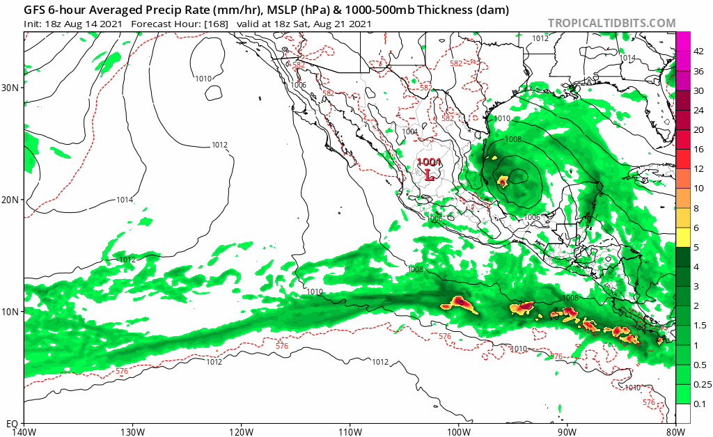
gatorcane wrote:The GFS is trying to get the EPAC going again in the long-range, should it get active again, could keep a lid on the Atlantic.
https://i.postimg.cc/SN5YCyHs/gfs-mslp-pcpn-epac-fh168-384.gif
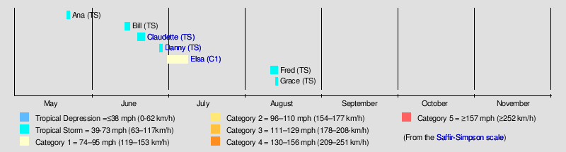
Teban54 wrote:Watching Fred and Grace largely struggling (for now) around the GA really shows how anomalous Elsa was, and how conducive the base state was that allowed a hurricane moving at almost 30mph to exist in early July.
I still think the basin will eventually return to those favorable conditions soon. Some people keep saying the flip is being delayed, but that might end up being worse because that will collide perfectly with the climatological peak season.
Category5Kaiju wrote:https://twitter.com/BMcNoldy/status/1426465678790365186
Very interesting tweet from Brian McNoldy a few days ago. Yes, Fred and Grace are struggling, but we nevertheless reached our 7th named storm even before hitting the August 15 mark and have a very real contender for the 8th named storm from 96L very soon (with this pace of NS formation only exceeded by 4 seasons, all of which were extremely active and impactful). Something tells me that after August 20, we won't be looking at this season the same way we are now, and the idea of slop storms, "2013 repeat," and all of these things are going to become a relic of the past.

AlphaToOmega wrote:gatorcane wrote:The GFS is trying to get the EPAC going again in the long-range, should it get active again, could keep a lid on the Atlantic.
https://i.postimg.cc/SN5YCyHs/gfs-mslp-pcpn-epac-fh168-384.gif
The GFS has been overestimating the EPac this year.
Users browsing this forum: No registered users and 168 guests


