Winter Weather Discussion
Moderator: S2k Moderators
Forum rules
The posts in this forum are NOT official forecast and should not be used as such. They are just the opinion of the poster and may or may not be backed by sound meteorological data. They are NOT endorsed by any professional institution or
STORM2K.
-
TeamPlayersBlue
- Category 5

- Posts: 3519
- Joined: Tue Feb 02, 2010 1:44 am
- Location: Denver/Applewood, CO
#2501 Postby TeamPlayersBlue » Mon Jan 19, 2026 12:06 pm
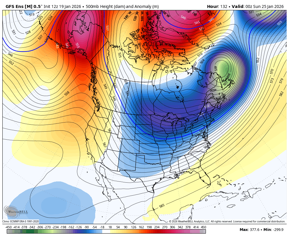
Ntxw wrote:jaguars_22 wrote:Idk I’m beginning to see the precip moving faster to the east and beating the cold… so my question is what kind of surprise do we need for the southern Texas area to get more sleet? Colder air? How do we get rid of the warm nose?
The upper level cold needs to be deeper, its aim right now is the midwest and Ohio valley, we are on the southwestern peripheral. More cold at the surface just means more ice accretion, verbatim, so a further westward/southward expansion at the upper levels is preferred. Scenario 2 is the ULL coming out and cooling the column west to east and surface low develop well into the gulf. This is for the regions you mentioned.
Right, ive been looking at soundings and temps are near 10C above the surface, below freezing at the surface. HUGE above freezing warm temps at altitude.
0 likes
Personal Forecast Disclaimer:
The posts in this forum are NOT official forecast and should not be used as such. They are just the opinion of the poster and may or may not be backed by sound meteorological data. They are NOT endorsed by any professional institution or storm2k.org. For official information, please refer to the NHC and NWS products.
-
ThunderSleetDreams
- S2K Supporter

- Posts: 1503
- Age: 43
- Joined: Tue Dec 20, 2011 4:42 pm
- Location: S of Weimar, TX
#2502 Postby ThunderSleetDreams » Mon Jan 19, 2026 12:07 pm
Cpv17 wrote:Stratton23 wrote:Cpv17 I dont know about that, models are extremely close to showing significant icing in the houston metro, id probably prepare for freezing rain on saturday, closer to the coast it might be just all cold rain
I’m just saying as of right now I’m not seeing much of an event for the Houston area. Could easily change.
Seen this song and dance before millions of times. SETX ends up getting the worst of it, from an icing perspective.
Those of us in Western and Northern SETX probably see the bullseye.
2 likes
#NeverSummer
I hibernate when it gets above 75 degrees!
-
ThunderSleetDreams
- S2K Supporter

- Posts: 1503
- Age: 43
- Joined: Tue Dec 20, 2011 4:42 pm
- Location: S of Weimar, TX
#2503 Postby ThunderSleetDreams » Mon Jan 19, 2026 12:14 pm
hurricane2025 wrote:CMC sucks, gfs isn’t good, euro all day. Se tx escapes
My guess is you’ll be wrong. I’ve seen this set up a lot since the late 80s. This isn’t a snow or really much sleet event for SETX, but I’m expecting a gnarly accretion of freezing rain for Hou metro. Hallettsville to Hempstead to Lufkin could be where the sleet starts to mix in.
Also you need to put a disclaimer in your signature since you speak in absolutes.
A lot of our customers read this forum and don’t need clown posts clogging up the board.
8 likes
#NeverSummer
I hibernate when it gets above 75 degrees!
-
Cpv17
- Category 5

- Posts: 5166
- Joined: Wed Dec 07, 2016 2:24 pm
- Location: Wharton/El Campo, TX
#2504 Postby Cpv17 » Mon Jan 19, 2026 12:15 pm
ThunderSleetDreams wrote:Cpv17 wrote:Stratton23 wrote:Cpv17 I dont know about that, models are extremely close to showing significant icing in the houston metro, id probably prepare for freezing rain on saturday, closer to the coast it might be just all cold rain
I’m just saying as of right now I’m not seeing much of an event for the Houston area. Could easily change.
Seen this song and dance before millions of times. SETX ends up getting the worst of it, from an icing perspective.
Those of us in Western and Northern SETX probably see the bullseye.
Yeah, I could see those areas getting something. South of I-10 and east of Highway 71 just looks like a cold rain.
0 likes
-
ThunderSleetDreams
- S2K Supporter

- Posts: 1503
- Age: 43
- Joined: Tue Dec 20, 2011 4:42 pm
- Location: S of Weimar, TX
#2505 Postby ThunderSleetDreams » Mon Jan 19, 2026 12:17 pm
Cpv17 wrote:ThunderSleetDreams wrote:Cpv17 wrote:
I’m just saying as of right now I’m not seeing much of an event for the Houston area. Could easily change.
Seen this song and dance before millions of times. SETX ends up getting the worst of it, from an icing perspective.
Those of us in Western and Northern SETX probably see the bullseye.
Yeah, I could see those areas getting something. South of I-10 and east of Highway 71 just looks like a cold rain.
I believe everywhere in SETX will see freezing rain minus Galveston. Some more than others with the onset of freezing temps.
1 likes
#NeverSummer
I hibernate when it gets above 75 degrees!
-
Cpv17
- Category 5

- Posts: 5166
- Joined: Wed Dec 07, 2016 2:24 pm
- Location: Wharton/El Campo, TX
#2506 Postby Cpv17 » Mon Jan 19, 2026 12:21 pm
ThunderSleetDreams wrote:Cpv17 wrote:ThunderSleetDreams wrote:
Seen this song and dance before millions of times. SETX ends up getting the worst of it, from an icing perspective.
Those of us in Western and Northern SETX probably see the bullseye.
Yeah, I could see those areas getting something. South of I-10 and east of Highway 71 just looks like a cold rain.
I believe everywhere in SETX will see freezing rain minus Galveston. Some more than others with the onset of freezing temps.
What I want to see is a surprise disturbance coming outta Mexico after the cold air is set in.
1 likes
-
Brazoria979cnty
- Tropical Low

- Posts: 11
- Joined: Sat Jan 17, 2026 5:45 pm
-
Contact:
#2507 Postby Brazoria979cnty » Mon Jan 19, 2026 12:21 pm
ThunderSleetDreams wrote:Cpv17 wrote:ThunderSleetDreams wrote:
Seen this song and dance before millions of times. SETX ends up getting the worst of it, from an icing perspective.
Those of us in Western and Northern SETX probably see the bullseye.
Yeah, I could see those areas getting something. South of I-10 and east of Highway 71 just looks like a cold rain.
I believe everywhere in SETX will see freezing rain minus Galveston. Some more than others with the onset of freezing temps.
do believe this as well..once that temp drops below freezing if there is still rain it will freeze
0 likes
-
Ntxw
- Storm2k Moderator

- Posts: 23307
- Joined: Wed Oct 21, 2009 6:34 pm
- Location: DFW, Texas
#2508 Postby Ntxw » Mon Jan 19, 2026 12:26 pm
We are still setting up for a potential February SSW. Don't be surprised if winter continues deep into February.


If you want to understand a little more on the precursors (wave 1 Aleutian low pattern) link below.
https://www.climate.gov/news-features/blogs/polar-vortex/cooking-stratospheric-polar-vortex-disruption
5 likes
The above post and any post by Ntxw is NOT an official forecast and should not be used as such. It is just the opinion of the poster and may or may not be backed by sound meteorological data. It is NOT endorsed by any professional institution including Storm2k. For official information, please refer to NWS products.
Help support Storm2K!
-
ThunderSleetDreams
- S2K Supporter

- Posts: 1503
- Age: 43
- Joined: Tue Dec 20, 2011 4:42 pm
- Location: S of Weimar, TX
#2509 Postby ThunderSleetDreams » Mon Jan 19, 2026 12:30 pm
Cpv17 wrote:ThunderSleetDreams wrote:Cpv17 wrote:
Yeah, I could see those areas getting something. South of I-10 and east of Highway 71 just looks like a cold rain.
I believe everywhere in SETX will see freezing rain minus Galveston. Some more than others with the onset of freezing temps.
What I want to see is a surprise disturbance coming outta Mexico after the cold air is set in.
Wouldn’t be uncommon. Mexico isn’t modeled well
0 likes
#NeverSummer
I hibernate when it gets above 75 degrees!
-
Ralph's Weather
- S2K Supporter

- Posts: 3318
- Age: 38
- Joined: Fri Dec 13, 2013 11:55 am
- Location: Lindale, TX
-
Contact:
#2510 Postby Ralph's Weather » Mon Jan 19, 2026 12:30 pm
I agree with the thought that precip types and the heaviest band will still shift south. 1050ish surface high pressing precip and the 850mb 0C line south. Freezing rain likely eventually reaches the coast. Worst icing likely along and a bit north of I-10. Once you near I-20 it could be more snow than currently depicted. Surface temps in the low to mid 20s along I-20 will make for nice snow if we can get 850mb 0C line far enough south. Hill Country to Deep East TX could see nasty icing.
3 likes
-
Ralph's Weather
- S2K Supporter

- Posts: 3318
- Age: 38
- Joined: Fri Dec 13, 2013 11:55 am
- Location: Lindale, TX
-
Contact:
#2511 Postby Ralph's Weather » Mon Jan 19, 2026 12:37 pm
Cpv17 wrote:ThunderSleetDreams wrote:Cpv17 wrote:
Yeah, I could see those areas getting something. South of I-10 and east of Highway 71 just looks like a cold rain.
I believe everywhere in SETX will see freezing rain minus Galveston. Some more than others with the onset of freezing temps.
What I want to see is a surprise disturbance coming outta Mexico after the cold air is set in.
I would watch for when the upper low ejects over Texas early week. If you assume the surface cold will be slow to erode then it could well drop a few inches of snow across the state. Also for more northern portions of the state we always have to watch the northern stream for little NW flow clippers that can overperform.
0 likes
-
wxman57
- Moderator-Pro Met

- Posts: 23159
- Age: 68
- Joined: Sat Jun 21, 2003 8:06 pm
- Location: Houston, TX (southwest)
#2512 Postby wxman57 » Mon Jan 19, 2026 12:39 pm
I'm waiting for the 12Z Euro to come in. GFS has Houston temps hovering near 30-32 Sat/Sun with about 0.4" of ice. GFS sounding indicates a significant warm layer aloft between 3000-12,000ft at the start of the precip. As the precip ends here Sunday, that warm (above-freezing) layer erodes. Couldn't rule out a few snowflakes as precip ends, but the primary impact would be freezing rain mixed with sleet.
For you folks up north around D-FW, 12Z GFS has 2-4 inches of snow now for the Metroplex Still too far out for any confidence. GFS tends to overdo these type of events. Let's see what the 12Z EC says...
4 likes
-
Quixotic
- Category 3

- Posts: 833
- Joined: Tue Feb 14, 2017 12:27 am
- Location: Frisco
#2513 Postby Quixotic » Mon Jan 19, 2026 12:42 pm
Seeing some goofy stuff. Sleet to snow back to sleet even as the cold deepens.
2013 was bad. 2003 was much much worse area wide. 3-5” of sleet. Was stuck in the house for a week as my main thoroughfare at that time was 635. Tried to go to the gym and sat in traffic for five hours to get to the next exit. Been better off if I tried to ice skate to the gym.
1 likes
-
txtwister78
- Category 5

- Posts: 2060
- Joined: Wed Jan 30, 2019 12:56 pm
- Location: San Antonio
#2514 Postby txtwister78 » Mon Jan 19, 2026 12:45 pm
The GEFS continues to trend colder further south and that's not unusual as these models play "catch up" with arctic air progression but with that trend you also increase the duration and timing of frozen precip further south as well.
So GFS op does have support from its ensemble
3 likes
-
TeamPlayersBlue
- Category 5

- Posts: 3519
- Joined: Tue Feb 02, 2010 1:44 am
- Location: Denver/Applewood, CO
#2515 Postby TeamPlayersBlue » Mon Jan 19, 2026 12:50 pm
ThunderSleetDreams wrote:hurricane2025 wrote:CMC sucks, gfs isn’t good, euro all day. Se tx escapes
My guess is you’ll be wrong. I’ve seen this set up a lot since the late 80s. This isn’t a snow or really much sleet event for SETX, but I’m expecting a gnarly accretion of freezing rain for Hou metro. Hallettsville to Hempstead to Lufkin could be where the sleet starts to mix in.
Also you need to put a disclaimer in your signature since you speak in absolutes.
A lot of our customers read this forum and don’t need clown posts clogging up the board.
I agree with you. Also, fully trusting the Euro in a winter event is what lead to the debacle in '21. Real weather dorks know you cant trust Euro temps at the surface in shallow arctic air events.
2 likes
Personal Forecast Disclaimer:
The posts in this forum are NOT official forecast and should not be used as such. They are just the opinion of the poster and may or may not be backed by sound meteorological data. They are NOT endorsed by any professional institution or storm2k.org. For official information, please refer to the NHC and NWS products.
-
orangeblood
- S2K Supporter

- Posts: 3817
- Joined: Tue Dec 15, 2009 6:14 pm
- Location: Fort Worth, TX
#2516 Postby orangeblood » Mon Jan 19, 2026 12:51 pm
txtwister78 wrote:The GEFS continues to trend colder further south and that's not unusual as these models play "catch up" with arctic air progression but with that trend you also increase the duration and timing of frozen precip further south as well.
So GFS op does have support from its ensemble
Its an outlier at the upper levels though, not going to get an accurate precip depiction being this disconnected right now. Would expect more of the typical northwest to southeast transition from rain/frz rn/sleet/snow (like its ENS Mean is showing) than the north to south tranistion that the GFS Op is showing right now. GFS OP looks off right now IMO
GFS OP

GEFS

0 likes
-
orangeblood
- S2K Supporter

- Posts: 3817
- Joined: Tue Dec 15, 2009 6:14 pm
- Location: Fort Worth, TX
#2517 Postby orangeblood » Mon Jan 19, 2026 12:54 pm
TeamPlayersBlue wrote:ThunderSleetDreams wrote:hurricane2025 wrote:CMC sucks, gfs isn’t good, euro all day. Se tx escapes
My guess is you’ll be wrong. I’ve seen this set up a lot since the late 80s. This isn’t a snow or really much sleet event for SETX, but I’m expecting a gnarly accretion of freezing rain for Hou metro. Hallettsville to Hempstead to Lufkin could be where the sleet starts to mix in.
Also you need to put a disclaimer in your signature since you speak in absolutes.
A lot of our customers read this forum and don’t need clown posts clogging up the board.
I agree with you. Also, fully trusting the Euro in a winter event is what lead to the debacle in '21. Real weather dorks know you cant trust Euro temps at the surface in shallow arctic air events.
Yep, CMC and ICON handled surface temps better during our extreme events while Euro is king at the upper levels
3 likes
-
snownado
- Category 5

- Posts: 1017
- Joined: Sat Dec 09, 2023 7:00 pm
- Location: Plano, TX
#2518 Postby snownado » Mon Jan 19, 2026 12:54 pm
If it has to happen, it better be a big snowstorm ala Feb. 2010.
An ice storm or a long duration 2-4" snow event would really just PMO (a native Midwestener)...
0 likes
-
wxman22
- Category 5

- Posts: 1774
- Joined: Mon Jan 30, 2006 12:39 am
- Location: Wichita Falls, TX
-
Contact:
#2519 Postby wxman22 » Mon Jan 19, 2026 12:58 pm
The 12z Euro AI is pretty aggressive with the storm.
2 likes
-
Ntxw
- Storm2k Moderator

- Posts: 23307
- Joined: Wed Oct 21, 2009 6:34 pm
- Location: DFW, Texas
#2520 Postby Ntxw » Mon Jan 19, 2026 1:00 pm
snownado wrote:If it has to happen, it better be a big snowstorm ala Feb. 2010.
An ice storm or a long duration 2-4" snow event would really just PMO (a native Midwestener)...
These types of events has the potential at least. QPF on virtually all of the ens means being this high is unusual for an arctic blast. We had high qpf in the first event last Jan but cold was much more limited. Least we got the players...all of the big snow high qpf storms generally look similar, just a matter of where...
2 likes
The above post and any post by Ntxw is NOT an official forecast and should not be used as such. It is just the opinion of the poster and may or may not be backed by sound meteorological data. It is NOT endorsed by any professional institution including Storm2k. For official information, please refer to NWS products.
Help support Storm2K!

Return to “Winter Weather”
Who is online
Users browsing this forum: 869MB, bigddstranny, Brazoria979cnty, Brent, cajungal, CaptinCrunch, Captmorg70, chickypez, DFW Stormwatcher, foulbeast, Gotwood, gpsnowman, Haddox12, HockeyTx82, jg5894, Kennethb, Ntxw, orangeblood, Ralph's Weather, rendihess, rylo7956, snownado, Sps123, texsn95, Tireman4, TomballEd, utpmg, WaveBreaking, WeatherP1, Will_TX, Wthrfan, wxman22 and 408 guests