ATL: KATIA - Post Tropical - Discussion
Moderator: S2k Moderators
-
ozonepete
- Professional-Met

- Posts: 4743
- Joined: Mon Sep 07, 2009 3:23 pm
- Location: From Ozone Park, NYC / Now in Brooklyn, NY
Re: ATL: KATIA - Hurricane - Discussion
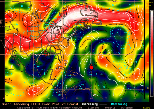
Looks like it could make cat 3 tonight. There is one big hitch, though. The latest CIMSS shear tendency shows an area of 20+ knots of shear just ahead of Katia to the west and northwest. And they have it as increasing tendency today. That doesn't bode well at all. Of course shear is pretty fluid and that area could weaken somewhat before Katia gets there. All the other factors are VERY positive for increasing intensity. But shear is king when it comes to intensity.
0 likes

Re: ATL: KATIA - Hurricane - Discussion
meriland23 wrote:Whats up guys, whats the new scoop? I see she not only went to a cat one, but a cat two! WOW. What is her long range track looking like?
it's looking more NE on the euro so it's lookin a bit more NE
i would look for another run of consistency from the euro tonite prior to "locking" this in...but today's 12z euro and ensmbles shifted toward a consensus
i mean the ukmet alone is not really that inspiring for confidence.
0 likes


Re: Re:
hurricaneCW wrote:fci wrote:So when all is said and done and the angst of the models, people harassing those who said "fish" and JB talking CONUS; it looks like climatology wins out and a recurving "fish".
Look back to page 1.
Yes, yes, yes...keep vigilance until it is for sure... But it looks good for a typical recurve.
It's not a typical recurve, a typical recurve is usually no further west than 60-65W, especially considering how far north Katia already is and how far west it's still going to come in early September is far from typical. And this "premature fish" is still expected to be damaging when it comes to rip currents, beach erosion, and high surf.
Really dont think that there is a definition debate for "recurve"!
0 likes
-
SapphireSea
- Category 1

- Posts: 430
- Joined: Wed Aug 24, 2005 12:13 pm
- Location: Miami, FL
Re: ATL: KATIA - Models
Yeah the setup should be favorable for a good sharp recurve. I don't rule out Bermuda getting some of this if this turn to the NNW becomes more pronounced earlier than expected.
0 likes
-
SapphireSea
- Category 1
- Posts: 430
- Joined: Wed Aug 24, 2005 12:13 pm
- Location: Miami, FL
Re: ATL: KATIA - Hurricane - Discussion
I don't think that there is an 'official' longitude that defines what is a "recurve" a recurve is a description of the overall track of the storm consisting of a NW - N - NE turn at any point in it's track. Whether or not the storm interacts with any land should not change the definition. Unofficially the term used here "Fish" storm would mean a recurving storm not directly affecting any land with it's LLC/Eye.
There is always going to be beach erosion, higher surf, and sadly deaths because of non-savvy swimmers in the waters. The pattern as it's pointed out by officials at the moment is pretty confident on a recurve with possible affects on Bermuda and little to no threat to the CONUS. I believe the storm is being pulled up further north far longer by the weakening trough to it's west than was originally forecast by even the more recent model runs. I believe the earlier and more eastern runs of the Euro and GFS will verify in this case, since they too showed the weak trough being more vigorous, before they began this bend to the WNW. I do not see a ridge developing over this storm in the next 24-48 hours which throws the UKMET into the trash.
The following post is NOT an official forecast and should not be used as such. It is just the opinion of the poster and may or may not be backed by sound meteorological data. It is NOT endorsed by any professional institution including storm2k.org For Official Information please refer to the NHC and NWS products.
0 likes
-
ozonepete
- Professional-Met
- Posts: 4743
- Joined: Mon Sep 07, 2009 3:23 pm
- Location: From Ozone Park, NYC / Now in Brooklyn, NY
Re: ATL: KATIA - Hurricane - Discussion
I'm looking at the water vapor satellite and the prog charts and I think the CIMSS analysis of shear and shear tendency that I posted earlier may be a little out to lunch. That narrow area of north-south shear is associated with the upper trough but that trough is lifting out and weakening. The problem with the CIMSS shear analysis (and many others) is that they are often behind real time and their tendency analysis shows tendency up 'til now, which doesn't tell us how it will change. They also often are off by as much as a hundred miles or more on the location of shear areas and can be off by 10 knots or even more on shear strength. And SHIPS has never been that good - not sayin' it isn't often correct, but it has been way off at times.
Anyway, given that the shear may be way over-exagerrated, and the fact that Katia has excellent symmetry and impressive outflow, and is going over very warm water and into a very moist mid-level environment, I think it should have no problem making cat 3 fast tonight.
Anyway, given that the shear may be way over-exagerrated, and the fact that Katia has excellent symmetry and impressive outflow, and is going over very warm water and into a very moist mid-level environment, I think it should have no problem making cat 3 fast tonight.
0 likes

I wish all members would put their general location in their profile. It just difficult to weigh one's comments, not knowing where they are from. We are a team, please join the rest of us, so the S2K team can factor in your comments based on your location to a storm. We won't bite if you give a location.
Eddie
Eddie
0 likes


Re:
M_0331 wrote:I wish all members would put their general location in their profile. It just difficult to weigh one's comments, not knowing where they are from. We are a team, please join the rest of us, so the S2K team can factor in your comments based on your location to a storm. We won't bite if you give a location.
Eddie
Thank you Eddie.
It really helps us put into perspective the comments that are made.
0 likes
-
CharlestonDoc
- Tropical Wave

- Posts: 3
- Joined: Sun Sep 04, 2011 6:07 am
- Location: Charleston, SC
Re: ATL: KATIA - Hurricane - Discussion
Beach erosion is definitely a real issue. We actually had a fair amount of beach damage and erosion just from the bit of Irene that swiped us here in Charleston, SC.
Why is it a "recurve" rather than just a curve? I've been wondering this for years. When did it curve the first time? Is it that it curves north and then northeast?
Why is it a "recurve" rather than just a curve? I've been wondering this for years. When did it curve the first time? Is it that it curves north and then northeast?
0 likes
-
ozonepete
- Professional-Met
- Posts: 4743
- Joined: Mon Sep 07, 2009 3:23 pm
- Location: From Ozone Park, NYC / Now in Brooklyn, NY
Re: ATL: KATIA - Hurricane - Discussion
CharlestonDoc wrote:Beach erosion is definitely a real issue. We actually had a fair amount of beach damage and erosion just from the bit of Irene that swiped us here in Charleston, SC.
Why is it a "recurve" rather than just a curve? I've been wondering this for years. When did it curve the first time? Is it that it curves north and then northeast?
LOL, that is a great question. Honestly I never thought of that. Aric (our resident physicist) would love that question.
0 likes
-
cycloneye

- Admin

- Posts: 149369
- Age: 69
- Joined: Thu Oct 10, 2002 10:54 am
- Location: San Juan, Puerto Rico
Re: ATL: KATIA - Hurricane - Discussion
00z Best Track
90kts.
AL, 12, 2011090500, , BEST, 0, 230N, 606W, 90, 965, HU
ftp://ftp.tpc.ncep.noaa.gov/atcf/tcweb/ ... 011.invest
90kts.
AL, 12, 2011090500, , BEST, 0, 230N, 606W, 90, 965, HU
ftp://ftp.tpc.ncep.noaa.gov/atcf/tcweb/ ... 011.invest
0 likes
Visit the Caribbean-Central America Weather Thread where you can find at first post web cams,radars
and observations from Caribbean basin members Click Here
and observations from Caribbean basin members Click Here

Re: ATL: KATIA - Hurricane - Discussion
Well the NHC showed 85 knots for the 11 am advisory so that means it strengthened 25 knots in 6 hours, that is officially Rapid Intensification. I had a feeling it was around 75 knots but since it was organizing so quickly they went for it, TS to CAT2. I'm confident it will become the 2nd major hurricane of the season. It would be interesting if it did it by 5 am EDT tomorrow.
Every time it seems a weak hurricane has rapid swirling deep convection motions around the eye, it indicates RI. A drop of 26 mb in 6 hours, is this the first time this year in the Atlantic a tropical cyclone has officially undergone RI?
My estimation for intensity is 95 knots. The eye hasn't changed much over the past few hours but if you take a closer look at both the water vapor loops and AVN imagery you will see that the convection is improving around the eye and cooling which is a positive sign for continuing the trend (this cycle has occurred twice so far today). I wonder if during the past 4 hours some dry air got in because some gaps of convection occurred outside of the eyewall but just now it looks to be shoring that up.
0 likes

Re: ATL: KATIA - Hurricane - Discussion
Cyclenall wrote:
Every time it seems a weak hurricane has rapid swirling deep convection motions around the eye, it indicates RI. A drop of 26 mb in 6 hours, is this the first time this year in the Atlantic a tropical cyclone has officially undergone RI?
We don't know how much or how quickly it strengthened. When it passed that buoy it showed the NHC's estimate was off by over 20mb. There is nothing to show that the NHC's estimate from 5am was even close to being accurate.
0 likes
Re: ATL: KATIA - Hurricane - Discussion
RL3AO wrote:We don't know how much or how quickly it strengthened. When it passed that buoy it showed the NHC's estimate was off by over 20mb. There is nothing to show that the NHC's estimate from 5am was even close to being accurate.
That's true but it's satellite presentation did improve a lot during that time. That is what recon is for, and I honestly don't know why they aren't out there now...landmass is in the forecast cone.
0 likes
Re: ATL: KATIA - Hurricane - Discussion
CharlestonDoc wrote:Why is it a "recurve" rather than just a curve? I've been wondering this for years. When did it curve the first time? Is it that it curves north and then northeast?
It's from the dictionary definition: To curve backward or in an opposite direction. I believe the word was first used in reference to archery bows whose tips curve away from the archer; but that may be legend.
0 likes
Who is online
Users browsing this forum: No registered users and 18 guests